Boston Skyline

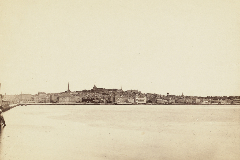
The skyline of Boston as seen across the Charles River in Cambridge, sometime in the 1880s. Image courtesy of the Boston Public Library.

712_1880-1889c bpl

The same view in 2015:

712_2015
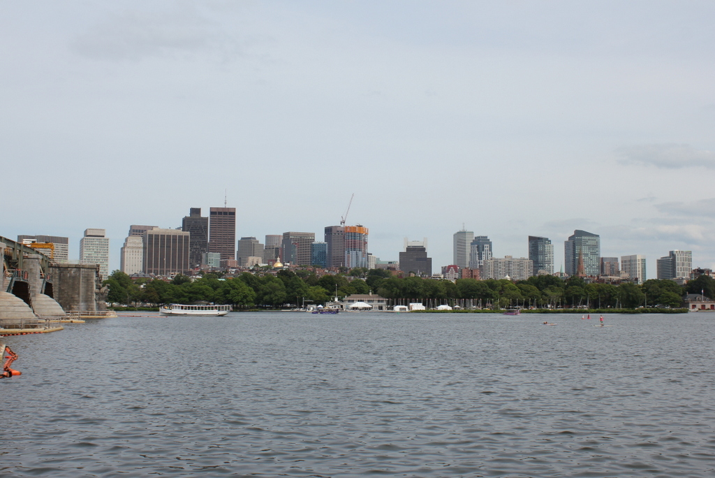
These two views certainly show how the city of Boston has changed over the past 125 years or so, but perhaps more remarkable is how much has remained the same.  This view shows an arc of the city from Cambridge Street and the Longfellow Bridge on the left to the foot of Mount Vernon Street on the far right, and the most obvious difference between the two photos is the skyscrapers of downtown Boston in the distance.

In the foreground, however, is the Beacon Hill neighborhood, which really hasn’t changed much since the 19th century.  Things are a little different along the waterfront – the trees of the Charles River Esplanade hide Storrow Drive, which cuts along the river now, but further up Beacon Hill this pocket of early 19th century Boston has survived as a low-rise residential neighborhood.  Although it is hard to identify individual buildings, many of the ones from the 1880s view are still standing today.  The most prominent building in the first photo is the dome of the Massachusetts State House, which stands at the top of the hill.  Although it now has a backdrop of skyscrapers instead of just sky, it is still easily visible from here despite being over a half mile from the river.

Matthews Arena, Boston

The Matthews Arena on St. Botolph Street in Boston, sometime during the 1920s. Image courtesy of the Boston Public Library.

711_1920-1929c bpl

The building in 2015:

711_2015
Here’s a question that would stump a lot of people: What is the oldest professional sports venue in Boston? The logical answer, of course, is Fenway Park, which opened in 1912.  However, less than a mile away from Fenway Park on the other side of the Back Bay Fens is the Matthews Arena, which was completed two years earlier as Boston Arena.  Over the years, this seemingly nondescript building has been used for various sporting events, political rallies, concerts, and other major events.  Both Theodore and Franklin Roosevelt held rallies here, and boxers such as Jack Dempsey and Joe Louis participated in matches here.

Many professional sports teams have had Boston Arena as their home arena; the Boston Bruins played their first home game here in 1924, and they remained here until the completion of the Boston Garden in 1928.  Later on, several minor league hockey teams played here, and from 1972-1973 the New England Whalers, later the Hartford Whalers and now the Carolina Hurricanes, played here.  The Boston Celtics also played here from their founding in 1946 until 1955, when they began playing all of their home games at Boston Garden.

Over the years, the arena has undergone some substantial changes, both outside and inside.  After several major renovations, the original exterior windows were bricked up, and the ornate entrance to the left has been replaced by a much simpler arch.  As built, it only had one level of seating, but the balcony was added in 1926, and today the it has a capacity of 6,000 for basketball and almost 5,000 for hockey, which is still a respectable capacity for a century-old arena.  Northeastern University has used it for their athletic teams since 1930, and they purchased it in 1979 and later renamed it the Matthews Arena in 1982.  Today, it is used by their Division I hockey and basketball teams, and it is among the oldest indoor hockey arenas in the world.

Blandford Street Incline, Boston

Facing east on Commonwealth Avenue toward Kenmore Square, with the Blandford Street Incline in the foreground, on January 3, 1933. Image courtesy of the City of Boston Archives.

710_1933-01-05 coba

The same location in 1943. Image courtesy of the City of Boston Archives.

710_1943 coba

The view in 2015:

710_2015
As mentioned in this post, trolley cars once entered and exited the subway from an incline in the median of Commonwealth Avenue just east of Kenmore Square.  However, in 1932 the tunnel was extended a little to the west, with one branch emerging here, at the present-day Boston University campus.  The first photo shows the incline shortly after it opened, and not much had changed ten years later when the second one was taken.

The most obvious change in the first two photos is the signs – by 1943 Kenmore Square had become home to many large advertisements, including ones for Dawson’s Pale Ale and Lager, Socony, the Hotel Kenmore, and Gulf.  Several of these signs were easily visible from Fenway Park, with the Gulf sign in particular being prominent in photographs of the park from that era.  Another sign in the foreground indicates that Park Street is a mere nine minutes away, which either suggests that the trolleys ran much faster than they do now, or that the Boston Elevated Railway was being a little generous in their estimates.

The second photo also reveals a largely forgotten piece of Boston history; the trolley coming up from the tunnel has “National League Park” as its destination.  Long before the Red Sox, the Boston Braves were the city’s original Major League Baseball team, and from 1915 to 1952, they played about a mile up Commonwealth Avenue from here.  After the team moved to Milwaukee for the 1953 season, the old stadium was purchased by Boston University and converted into Nickerson Field, with some of the original structure still standing today.

In the 2015 scene, the subway incline hasn’t changed much; even the poles supporting the overhead wires appear to be the same ones from the first two photos.  To the left, the Boston University campus has continued to expand, and today several of BU’s buildings are visible here.  In the distance, many of the buildings in Kenmore Square are still standing, and although none of the 1940s signs still exist, Kenmore Square is now home to arguably the city’s most famous sign, which appears to be located at the same spot as the old Socony sign.  This Citgo sign is visible over the Green Monster at Fenway Park, and has been identified with the Boston Red Sox ever since it was first constructed in 1965.