North Wilbraham Station, Wilbraham, Mass

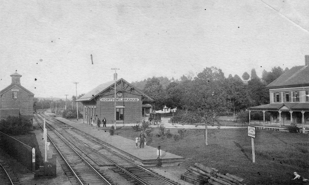
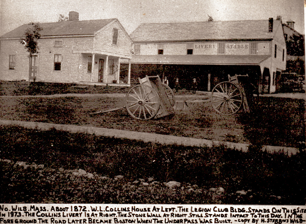
The North Wilbraham Station on the Boston & Albany Railroad, around 1890. Image courtesy of the Wilbraham Public Library.
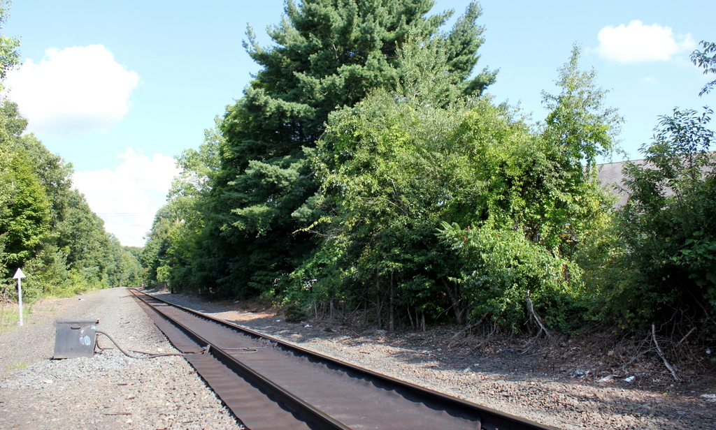
745_1890c wpl

The scene in 2015:

745_2015
Although Wilbraham is a fairly small town, it lies on one of the primary east-west transportation corridors in New England.  In the 1630s, the Bay Path crossed what would later become the northern edge of the town, connecting Boston and Springfield.  Later, this route was incorporated into one of three branches of the Boston Post Road between Boston and New York.  So, when railroads were beginning to be developed in the 1830s, this same route along the Connecticut River was a logical choice for a railroad line.  Heading west from Boston, railroads reached Worcester in 1835, and four years later the Western Railroad was completed, connecting Worcester to Springfield.  These companies would later be consolidated into the Boston & Albany Railroad.

One of the original stations on the Western Railroad was here in Wilbraham, although it was located almost three miles west of here, at the present-day Stony Hill Road underpass.  In 1851, though, this station was moved about a mile west into Springfield, to Oak Street in Indian Orchard.  A new Wilbraham station here at North Wilbraham was established around the same time, and the station seen in the 1890 photo was built in 1872.  By the time the first photo was taken, there were four to five scheduled trains in each direction that stopped in North Wilbraham.  As the sign indicates in the photo, it was the station for Wesleyan Academy, which was later renamed Wilbraham Academy and is now Wilbraham-Monson Academy.   From here, travelers would board a stagecoach for the remaining two miles to the academy.

However, with the decline of passenger rail in the mid-1900s, train stops in Wilbraham were gradually reduced until 1957, when the station was closed.  It was demolished the following year, and today no trace remains of it or any of the associated buildings.  The old Boston & Albany line is now owned by CSX, and as seen in the 2015 photo it has been reduced from two tracks to one between Springfield and Palmer.  The only passenger train that still operates through here is Amtrak’s Lake Shore Limited, which runs daily from Boston to Chicago without stopping in Wilbraham.

Collins Inn Livery Stable, Wilbraham, Mass

The livery stable at the Collins Inn on Boston Road in North Wilbraham, around 1895. Image courtesy of the Wilbraham Public Library.

744_1895c wpl

The scene in 2015:

744_2015
This is the same building seen in the previous post, just from a different angle and several years later.  Although the photo is undated, there is at least one clue that gives a good indication of when it was taken.  Just below the large “Livery” sign, there are posters for Buffalo Bill’s Wild West, which was performing in Springfield on “Thursday, May 23.”  There appears to have been a performance in Springfield on that day in 1895, and it was a Thursday, so the photo was probably taken around that time.

In the days before automobiles, livery stables such as these would have provided stabling and feed for horses, and the carriages out front show a variety of horse-drawn carriages that would have been used at the time.  One of the carriages has two young children sitting in it, so perhaps the man posing with the horse is about to hitch it to that carriage.  He is presumably an employee of the stables, which was operated as part of the Collins Inn next to it.

At the time that the first photo was taken, cars were just starting to be developed, but within about 20 years they would essentially replace horses, putting livery stables like these out of business.  Perhaps not coincidentally, the Collins Inn closed in 1915.  I don’t know when the stables were demolished, but it seems fitting that the modern equivalent, a gas and repair station, now stands on the site.

Collins House and Livery Stable, Wilbraham, Mass

The Warren Collins home and livery stables, on Boston Road in North Wilbraham, possibly around 1872. Image courtesy of the Wilbraham Public Library.

743_1872c wpl

The scene in 2015:

743_2015
These buildings can be seen in the distance of the c.1900 photo in the previous post, which explains the history of the Collins Inn that once stood nearby.  This location was directly across the street from Wilbraham’s only railroad station, and it was from here that Warren L. Collins operated a stagecoach line to the center of town, two miles away.  The livery stables in the background were probably used to house the horses for this line.  Given the nature of livery stables, it probably would have also been used to care for the horses of the inn’s guests.

The one thing that is in question about this photo is the date. A copy of this image can be found online here, which is where the 1872 date comes from.  However, that date might be a little too early; the 1873 atlas of Hampden County includes an inset map of North Wilbraham, which was labeled as Collins Depot.  Neither of these buildings appear on the map, and a different building on the other side of the street is labeled as the livery stables.  Additionally, the Collins Inn was not built until 1874, and the 1964 History of Wilbraham book suggests that Collins built this livery stable at some point after opening the inn.  So, it seems more likely that the photo was taken either a little later in the decade or maybe in the 1880s.

Either way, there is not much left from the old photo.  Both the stables and the small house in the foreground are gone, but the basic business model is still going on here today.  Instead of feeding and caring for horses, the present-day business performs a very similar function, providing fuel and repairs for cars.  There also appears to be at least one surviving element from the original photo; the building on the far left looks like it is the same one that was standing there.

Collins Inn, Wilbraham, Mass

Collins Inn at the corner of Boston Road and Chapel Street in North Wilbraham, probably in the 1890s or early 1900s.  Image courtesy of the Wilbraham Public Library.

742_1800sc wpl

The scene in 2015:

742_2015
The historic center of the town of Wilbraham has always been along Main Street in the town’s approximate geographic center.  When it was first settled in the 1700s, this was the ideal place for farming, but as changes in industrialization, transportation, and communication came about in the 1800s, the village of North Wilbraham gained prominence.  Its location on the banks of the Chicopee River and along the main road from Springfield to Boston made this area an important spot for industry and transportation.  In 1839, the Boston & Albany Railroad opened through here, with the North Wilbraham railroad station being located right across the street from here.

The building in the foreground of the first photo was the Collins Inn, which was opened in 1874 by Warren L. Collins.  It sat directly across Boston Road from the railroad station, and across Chapel Street from the Hollister Block, which at the time was used as a drugstore and post office.  In addition to the inn, Collins also operated a livery stable on the site, and ran a stagecoach line from here to the center of Wilbraham, about two miles away.

Aside from transportation, though, the Collins inn also offered Wilbraham another connection to the outside world – the telephone.  The telephone was invented in 1876, and within just four years a line was established from here to the center Wilbraham, at a cost of $30 per year for subscribers.  However, a few years later the cost increased to $100 per year (equivalent to over $2,400 today), and the service was discontinued because of a lack of families willing to pay.  When phone service was re-established in 1904, the Collins Inn became the town’s telephone exchange office for the New England Telephone and Telegraph Company, serving 21 customers in Wilbraham.

The telephone exchange remained here until 1914, when it moved to a different building across the street.  Around the same time, the Collins Inn closed, although the building itself remained standing for some time.  The 1964 History of Wilbraham book indicates that it was still standing at the time, although today its former location is now a parking lot.

Portland Head Light, Cape Elizabeth, Maine (3)

Another view of Portland Head Light, probably taken around the 1870s. Image courtesy of the New York Public Library.

741_1865-1883c nypl

The lighthouse in 2015:

741_2015
The first photo here was probably taken around 10-20 years before the ones in the previous two posts here and here, and it shows the tower as it appeared following its 1865 height change.  As mentioned in more detail in the first post, the lighthouse was built in 1791, but was reduced in height by 20 feet in 1812, to the spot below the lantern where a horizontal band runs around the tower.  Those 20 feet were restored in 1865, as seen in the first photo, but the tower was trimmed down again in 1883.  Just two years later, though, enough sailors complained that it was raised 20 feet yet again, with changes such as a larger lantern room at the top and  a second gallery below it.  Since 1885, it hasn’t seen very many changes, and it remains an active lighthouse as well as a popular tourist destination along the southern coast of Maine.

Portland Head Light, Cape Elizabeth, Maine (2)

Another view of Portland Head Light, taken from the north side probably around 1890. Image courtesy of the Library of Congress, Detroit Publishing Company Collection.

740_1900-1910c loc
The lighthouse in 2015:

740_2015
The angle here isn’t exact; the first photo was taken from the water, a little to the left of where the 2015 photo was taken.  The previous post explains more about the history of the lighthouse, which was built in 1791 on a rocky outcropping at the entrance to Portland Harbor.  The first view was presumably taken around the same time as the one on the other post, because it shows the old 1816 keeper’s house, which was replaced by the current one in 1891.

Being surrounded by water on three sides and facing the open ocean provides some dramatic views for visitors and photographers, and it probably also provided the inspiration for Henry Wadsworth Longfellow’s poem “The Lighthouse.”  Longfellow grew up in Portland, and the certainly seemed to be describing this lighthouse, writing in the first two stanzas:

The rocky ledge runs far into the sea,
And on its outer point, some miles away,
The Lighthouse lifts its massive masonry,
A pillar of fire by night, of cloud by day.

Even at this distance I can see the tides,
Upheaving, break unheard along its base,
A speechless wrath, that rises and subsides
In the white lip and tremor of the face.

The lighthouse would have looked a little different when Longfellow wrote the poem, though.  The keeper’s house would have been the same as the one in the first photo, but as mentioned in the previous post, its height was periodically changed throughout the 19th century, and did not assume its present-day appearance until 1885, three years after Longfellow’s death.  Today, with the old keeper’s house gone, the only thing left from Longfellow’s childhood visits is the section of the tower below the horizontal band a little below the lantern.