View from the Arsenal Tower, Springfield, Mass (1)

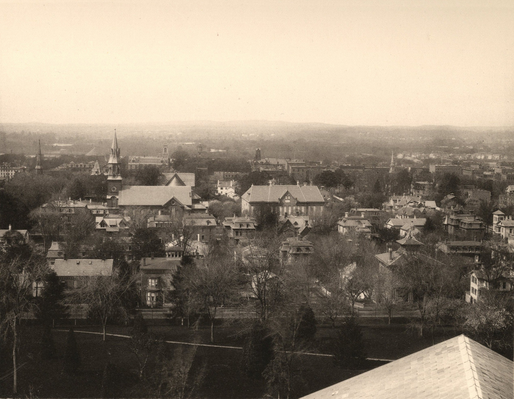
Looking southwest toward downtown Springfield from the Arsenal tower, around 1882. Photo from Springfield Illustrated (1882).

837_1882c spfldillustrated

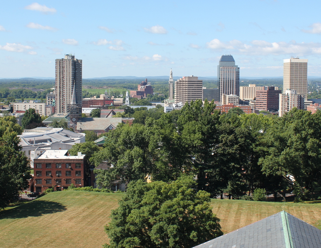
The view in 2015, photographed with permission from the Springfield Armory National Historic Site.

837_2015
When the first photo was taken around the early 1880s, Springfield was in the midst of a period of rapid growth. In the previous 20 years, the city’s population had more than doubled to 33,340 people by 1880, thanks in no small part to the presence of the Armory where the photo was taken. The Main Street corridor in the distance had become a major commercial center for the entire region, and the slope in the the foreground at the base of the Armory hill had developed into an affluent residential area. Most of the buildings in the first photo were built in the 1860s or 1870s, including most of the houses seen here. Other major landmarks visible here include St. Michael’s Cathedral, which is easily visible on the left side, and St. Michael’s Hall, in the center. Just to the left of St. Michael’s Cathedral is the tower of the old library building, and to the left of it is the steeple of the Church of the Unity. Further in the distance, beyond St. Michael’s, is the Hampden County Courthouse, with the steeple of Old First Church barely visible to the right of it, along with the tower of the old City Hall building in approximately the upper center of the photo.

As dramatic as the population increase had been by the time the first photo was taken, the growth would continue at an even more dramatic pace over the next 50 years, with the population reaching almost 150,000 by 1930, almost 4.5 times the 1880 population. Much of this growth was in the suburban parts of the city, but the downtown area also saw significant development. However, unlike many other comparably-sized cities in the northeast, Springfield’s skyline did not see many dramatic changes until later in the 20th century. From 1908 to 1970, a state law prohibited any buildings taller than the 125-foot steeple of Old First Church, with the exception of the Springfield Municipal Group Campanile tower. Since 1970, though, downtown Springfield has grown upward, starting with the 29-story Baystate West, now named Tower Square, which is visible on the far right of the photo. Other skyscrapers soon followed, including the Chestnut Park apartment building on the left side of the photo, and Monarch Place, just to the right of the center.

Many of the historic structures from the first photo are now gone, including the old library, the Church of the Unity, and St. Michael’s Hall. Many of the Victorian single-family homes and duplexes are also gone, having been replaced by apartment blocks as the city grew in the first half of the 20th century. Some, however, are still standing, including the two brick houses on Byers Street in the foreground that have towers on their roofs. A few blocks further down the hill, mostly hidden by the trees, is the Quadrangle-Mattoon Street Historic District, which includes many buildings that were standing when the first photograph was taken. The Armory itself, including the Arsenal tower where these photos were taken, is also a historic site. It closed in 1968, and is now the home of Springfield Technical Community College as well as the Springfield Armory National Historic Site.

For other then and now views from the Arsenal tower, see the other posts showing the view facing west, northwestsouth, and north.

First Friendly’s Restaurant, Springfield, Mass

The original home of Friendly Ice Cream, at 161 Boston Road in Springfield, around 1938-1939. Image courtesy of the Springfield Building Department.

The scene in 2019:

The first photo was taken only a few years after S. Prestley and Curtis Blake opened the first Friendly Ice Cream location here in Springfield’s Pine Point neighborhood. In 1935, the two brothers, aged 20 and 18, respectively, borrowed $547 from their parents and opened the ice cream shop, charging 5 cents for a two scoop cone as the sign on the side of the building indicates. The business soon proved to be popular, and in 1940 they opened a second shop in West Springfield. By the early 1950s, they had 10 locations in the area, and when the Blake brothers sold the company in 1979, it had grown to over 500 restaurants. Today, the company operates 380 restaurants along the east coast from Maine to Florida.


The buildings in the first photo were probably built in the 1920s or early 1930s, when Pine Point was growing as a middle class residential neighborhood. As seen here and in this earlier post, these commercial buildings are all still standing, but the change in use has reflected some of the changes in the neighborhood over the years. The original Friendly’s has long since closed, and its storefront is now a pizza restaurant, and to the right the First National supermarket has been divided into two smaller storefronts. Directly across the street from here was Nora’s Variety Store, a Pine Point fixture for many years that, likewise, has closed, and now stands vacant.

USS Detroit at Boston Navy Yard

The cruiser USS Detroit in Dry Dock 2 at Boston Navy Yard, on December 16, 1928. Image courtesy of the Boston Public Library, Leslie Jones Collection.

835_1923-1934c bpl

The scene in 2015:

835_2015
Taken about 23 years after the photo in the previous post, this view of Dry Dock 2 shows the USS Detroit (CL-8), an Omaha-class light cruiser, undergoing work at the Boston Navy Yard. The Detroit had been built in nearby Quincy, Massachusetts, and was commissioned in 1923. Several years after the first photo was taken, she was transferred to the Pacific, and was based out of San Diego before being moved to Pearl Harbor in 1941. She was present during the attack on Pearl Harbor on December 7, and survived the battle without any damage, and went on to see extensive service in World War II, including being present in Tokyo Bay for the surrender in 1945. Following the war, though, the Detroit was sold for scrap in 1946, along with many other obsolete surplus ships.

The Boston Navy Yard, as mentioned in the previous post, closed in 1974, and part of it was taken over by the National Park Service. Today, many of the historic buildings and other structures have been preserved, including Dry Dock 2 and some of the buildings in the distance. One of the most distinctive buildings in the yard is the octagonal Muster House, which can be seen just to the left of the ship. It was built in the 1850s, and it is still standing today, partially hidden by trees in the distance. The long building in the center of the photo has also been preserved and repurposed; it is now the MGH Institute of Health Professions.

USS Maryland at Boston Navy Yard

The cruiser USS Maryland in Dry Dock 2 at the Boston Navy Yard, around 1905. Image courtesy of the Library of Congress, Detroit Publishing Company Collection.

834_1905c loc

The scene in 2015:

834_2015
The first photo shows Dry Dock 2 at the Boston Navy Yard, which was completed in 1905, not long before the first photo was taken. It was part of a large expansion of the facility, and it supplemented the much older and smaller Dry Dock 1. At 750 feet long, it could accommodate the Navy’s newest ships, including the Maryland, a Pennsylvania-class armored cruiser that, like the dry dock, was completed in 1905.

In the years after the photo was taken, the Maryland was eventually renamed the Frederick to free up the name for a new battleship, and the ship served in World War I. Like many other early 20th century American warships, though, the ship’s service history was brief. She was decommissioned in 1922, and sold for scrap in 1930.

As for the Boston Navy Yard, it remained in use throughout World War I, World War II, and beyond. It was finally closed in 1974, and part of it was taken over by the National Park Service as part of the Boston National Historical Park. Dry Dock 2 is just outside the park limits, but it is still intact, including the pump house, the small round building directly in the center of the 2015 photo. Just to the left of the pump house is Flagship Wharf, one of several modern condominium complexes that have been built on parts of the former navy yard.

For another scene of Dry Dock 2 in use, see the historic photo in this post, taken in 1929.

Custom House Tower, Boston

The Custom House Tower in Boston, as seen from Quincy Market during its construction, around 1913-1915. Image courtesy of the Boston Public Library.

833_1913-1915c bpl

The scene in 2015:

833_2015
As explained in this earlier post, Boston’s Custom House was built in 1849, with a convenient location near Long Wharf that easily allowed officials to inspect incoming cargoes. Boston’s role as major seaport grew over the years, though, and by the early 1900s it was necessary to expand it. Rather than demolishing the old building, though, they simply added a 32-story skyscraper on top of it. At the time, Boston had a 125 foot limit on skyscrapers in the city, but as a federal building the Custom House Tower was exempt. At 496 feet tall, it was nearly four times the maximum height, and it dominated the Boston skyline for many years, as this early 1930s view of the city shows.

The c.1913-1915 photo above shows the building during its construction, with the original 1849 structure clearly visible at its base. It would remain the tallest building in the city until the completion of the Prudential Tower nearly 50 years later, and it would be used by US Customs until 1986 when they moved into the Thomas P. O’Neill, Jr. Federal Building. After a long period of vacancy, the historic tower is now a Marriott Hotel, and it is part of the Custom House District on the National Register of Historic Places.

School Street, Boston

Looking up School Street from Washington Street in Boston, around 1860. Image courtesy of the Boston Public Library.

832_1860c bpl

School Street in 2015:

832_2015
School Street is only a couple hundred yards long, yet this narrow downtown street has been home to a number of historic sites. The entire street is part of the Freedom Trail, and notable sites along here include King’s Chapel at the Tremont Street end and the Old Corner Bookstore on the right, here at the Washington Street end. In between, opposite Province Street, were two generations of Boston City Hall buildings, built on the former site of the Boston Latin School. The street is named for this school, which was here from 1704 to 1748, and during that time educated future Founding Fathers such as Benjamin Franklin, John Hancock, Samuel Adams, and Robert Treat Paine. Another School Street landmark, which has long since been demolished, was the original Parker House hotel, which was built in 1855 and is barely visible in the distance on the left side, on the site of the present Omni Parker House. A couple notable guests who visited the hotel not long after the first photo was taken included John Wilkes Booth, who stayed here eight days before assassinating Abraham Lincoln, and Charles Dickens, who lived here for five months in 1867-1868 during his tour of the United States.

The School Street that Charles Dickens would have seen was a narrow, busy street, and today not much has changed in that regard. In fact, the 1860 scene was probably busier than it appears. There are no pedestrians visible, which was probably due to the photographer using a long shutter speed, but in all likelihood there were plenty of people walking around at the time. None of the buildings are still standing from the first photo, though, except for the barely-visible King’s Chapel in the distance and the Old Corner Bookstore on the far right. The original part of the bookstore was built in 1712, and it was expanded up School Street in 1828 with the construction of the two three-story brick buildings on the right.