William G. Pierce House, Springfield, Mass

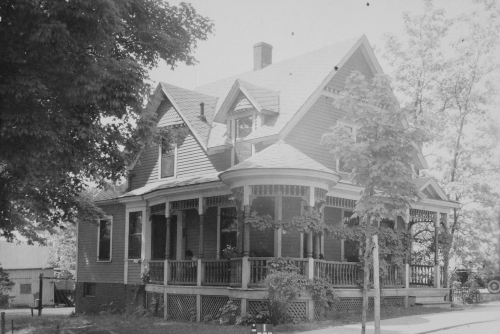
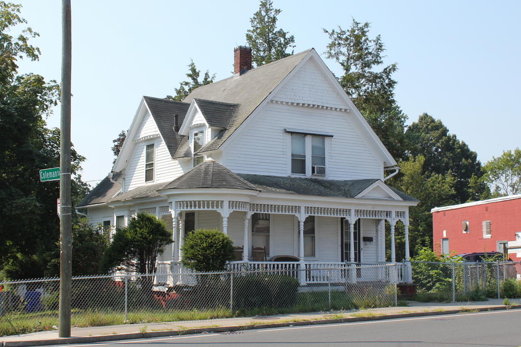
The house at 171 Boston Road, at the corner of Coleman Street in Springfield, on October 4, 1938. Image courtesy of the Springfield Building Department.

The house in 2019:

Today, Boston Road a busy four-lane road, lined with gas stations, restaurants, shopping plazas, used car dealerships, and other commercial development for most of its 3.3-mile length from Pine Point to the Wilbraham town line. However, as discussed in a previous post, this section of Springfield was lightly populated prior to the early 20th century. While passing through here in 1789, George Washington had described the area as “an almost uninhabited Pine plain,” and not much would change for another century, despite being located on the main route from Springfield to Boston. Much of this had to do with the poor quality of the soil, which made the land undesirable for farming. Distance was also a factor in this; modern-day Pine Point is about three miles from downtown Springfield, which made it impractical to commute into the city on a daily basis.

However, things had begun to change by the late 19th century, when a number of Boston Road landowners began subdividing their properties with new streets and house lots. This was likely spurred by the opening of a trolley line nearby on Berkshire Avenue, which linked downtown Springfield to Indian Orchard. Residents here could now commute to either location, or take connecting lines to other destinations, and by the early 20th century Pine Point had been transformed into a working class suburban neighborhood.

Over the years, nearly all of the old homes here on Boston Road have been demolished, either to clear the way for a new subdivision or to repurpose the land for commercial use. This house, located at the corner of Boston Road and Coleman Street, appears to be the oldest surviving house on Boston Road, and probably the only one that predates the development of the modern street grids.

It is difficult to determine the exact date when this house was built, in part because houses in the outlying areas of the city generally did not have street numbers during the 19th century. Various maps show houses in this vicinity as early as 1835, but it is not easy to tell exactly which houses were which. The documentation on the state’s MACRIS database lists it as having been built around 1882, based on atlases and directories of the period, and this seems like a plausible date, particularly since its Queen Anne-style design matches with architectural tastes of the early 1880s. In many ways, its design resembles a smaller version of the much larger Queen Anne houses that were built in the city’s McKnight neighborhood around the same time.

The first recorded resident of this house was William G, Pierce, who appears in the 1882 city directory as a merchant of the firm William G. Pierce & Co. However, he is not listed in either the 1881 or 1883 directories, so his stay here at this house may have been short. The next 15 years of this house’s history are unclear, but by 1897 it was owned by Julien W. Belanger, a merchant tailor who lived here with his wife Corinne, their five children, and a servant. His tailor shop was located on Main Street in downtown Springfield, and he likely would have used the new trolley line to commute to work. He and his family were living here as late as 1900, but by 1901 they had moved to Adams Street, and by 1904 they had moved to Canada, where both Julien and Corinne had been born.

By 1905, this house was being rented by Michael and Mary Byrne, who lived here with their four children. Like the Belangers, they were also immigrants, with Michael from Scotland and Mary from England. In city directories of the period, Michael is listed as a papermaker, although according to the 1910 census he was an automobile machinist. The census also lists their son Adam as having the same occupation, while their daughter Mary was a saleswoman at a department store, and their son Charles was an assistant bookkeeper at a department store.

The Byrne family left Springfield soon after the 1910 census, and by 1912 this house was owned by Albin M. Kramer, a civil engineer who had immigrated to the United States from Germany as a young child in 1872. His wife Rose was also an immigrant, from England, and they had married within a few years after her arrival in 1899. During the 1920 census, they were living here in this house with their children Alwin, Frederick, Vincent, and Marguerite, who ranged in age from 10 to 16.

Of the four Kramer children, Alwin would probably go on to have the most noteworthy career. He was 16 years old during the 1920 census, and a year later he graduated from Central High School. From there he went to the U. S. Naval Academy thanks to an appointment by Springfield’s Congressman Frederick H. Gillett, who was at the time the Speaker of the House. Alwin went on to have a long career in the Navy, but he is best remembered for his role in the events leading up to the attack on Pearl Harbor.

In 1939, Alwin became the head of OP-20-GZ, which was involved in intercepting, decrypting, and translating coded messages sent by the Japanese government. He was particularly busy in early December 1941, when his office decrypted a series of 14 messages sent to the Japanese embassy in Washington D.C. The last of these, sent in the early morning hours of December 7, instructed the Japanese ambassador to end diplomatic relations with the United States. However, it did not specifically indicate that an attack or a declaration of war was imminent, and there were a number of delays in Washington before this information was finally sent to Pearl Harbor, arriving several hours after the attack.

Alwin Kramer would go on to serve with distinction in World War II, and was eventually promoted to captain. However, his actions in early December, and those of his colleagues and superiors, fell under increased scrutiny after the war, eventually leading to a Congressional inquiry in 1946. The hearings were likely politically motivated, in an attempt by Republicans to discredit the Roosevelt and Truman administrations, but Captain Kramer did himself no favors with his confusing and often contradictory testimony, and he ended up retiring from the Navy by the end of the year. Nonetheless, he was never formally assigned any blame, and his wartime promotions suggest that his superiors in the Navy did not find fault in his actions. He died in 1972 at the age of 69, and he was buried in Arlington National Cemetery.

In the meantime, Kramer’s family continued to live here in his childhood home until around 1929, although by the 1930 census his parents and two younger siblings were living in a house at 127 Massachusetts Avenue. The next long-term residents here at 171 Boston Road were Walter and Mazie Spickler, who were here as early as 1933. They were both in their mid-40s at the time, and they lived here with their son George and his wife Edna. George and Edna subsequently moved to a house of their own on nearby Denver Street by 1937, but Walter and Mazie were still here on Boston Road when the first photo was taken in 1938. According to the 1940 census, they paid $37 per month in rent, and Walter earned $1,560 per year as a fireman at a cotton mill.

Walter Spickler died shortly after the census was taken, in September 1940, at the age of 54. Mazie continued to live here for at least a few more years, and the 1944 city directory shows her working as an inspector at Westinghouse. However, she moved by the following year, because the 1945 directory shows Franklin and Virginia Lewis living here. At the time, Franklin was working as a collector for the Springfield Union newspaper, and he later became the circulation supervisor for the Springfield Newspapers. He lived here until his death in 1969, at the age of 64. It seems unclear as to how much longer Virginia lived here, but she ended up outliving Franklin by more than 40 years, before her death in 2010 at the age of 104.

Today, more than 80 years after the first photo was taken, remarkably little has changed in this scene. The property is now surrounded by a chain link fence, and the house appears to have a different paint scheme, but otherwise its exterior looks essentially the same as it did in the 1930s. The shed in the backyard on the far left is also still there, as is the brick building on the far right side. Although mostly hidden by trees in the first photo, this building was here in the 1930s, and it is best known as the site of the first Friendly’s restaurant, which opened here in 1935. In general, very few historic buildings have survived the various waves of development along Boston Road, but this house stands as an unusual reminder of what Springfield’s main commercial thoroughfare once looked like.

Stetson Hardware, Springfield, Mass

Stetson Hardware at 162-164 Boston Road in Springfield, on October 12, 1938. Image courtesy of the Springfield Building Department.

The scene in 2019:

This building was constructed around 1919, at the corner of Boston Road and Jasper Street in Springfield’s Pine Point neighborhood. At the time, Pine Point was in the process of being developed as a residential suburb, and this section of Boston Road was becoming its main commercial center. This was among the first commercial buildings in this area, and it was built of wood, unlike the brick ones that would be built across the street from here in the 1920s and 1930s.

The building originally consisted of two separate storefronts, with the one on the left at 162 Boston Road, and the one on the right at 164 Boston Road. In the fall of 1938, when the first photo was taken, the storefront on the left was vacant and available for rent, as indicated by the signs in the windows. On the right side, this storefront was occupied by Stetson Hardware, which was owned by Louis C. Stetson. During the early 1930s he had worked as a shipping clerk, but around 1936 he went into business for himself, with a hardware store on Orange Street. He moved his store here to Boston Road around 1937, and according to the sign in the photo he sold paints, varnish, glass, kitchenware, and novelties. However, his business evidently did not last, because it last appears in city directories in 1940, and by 1941 he was listed as working in a warehouse in West Springfield.

By the late 1940s, Stetson’s former store had become A. C. Winckel, a paint store owned by Adam C. Winckel. He died in 1951 at the age of 48, but his widow Ada carried on the business for many years, until at least the mid-1960s. Then, at some point in the second half of the 20th century, the building was heavily altered with a new front facade, along with vinyl siding on the rest of the exterior. Overall, though, it is still recognizable from the first photo, and it stands as one of the oldest surviving commercial buildings in Pine Point.

Boston Road from Coleman Street, Springfield, Mass

Looking west on Boston Road from near the corner of Coleman Street in Springfield, around 1924. Image from Catalogue of the Flowering Plants and Ferns of Springfield Massachusetts (1924).

The scene in 2019:

The primary subject matter of the first photo was intended to be the tree in the foreground, which is identified as Acer rubrum L. var. tridens Wood, a rare variety of red maple. However, the photo also captures a rare view of Boston Road as it appeared nearly a century ago, prior to its extensive commercial development. The view faces west along Boston Road from the corner of Coleman Street, right in the midst of what would soon become the center of the Pine Point neighborhood.

Throughout most of the 19th century, this section of Springfield was only sparsely settled, with the 1870 city map showing fewer than 20 houses along the entire 3.5-mile stretch of Boston Road from Berkshire Avenue to the Wilbraham town line. This began to change by the 1890s, though. Likely motivated by the recently-opened trolley line on nearby Berkshire Avenue, landowners in present-day Pine Point began subdividing their properties with new streets and house lots. By 1899 there were at least six houses on Coleman Street, and over the next two decades there would be further development, particularly on Denver and Jasper Streets.

Overall, though, the neighborhood maps of the early 20th century show far more vacant lots than houses, and it would take many years before most of the streets were fully developed. The first photo was taken during this period, when even Boston Road, the main thoroughfare through Pine Point, still had many empty lots and hardly any commercial development.

There are only two houses visible in the first photo. On the left, at the southwest corner of Boston Road and Coleman Street, is one of the oldest surviving houses in the area. It was built sometime around 1882, predating the modern street grid that was added about a decade later, and during the early 1880s it was the home of merchant William G. Pierce. Subsequent owners included tailor Julian Belanger, and by the time the first photo was taken in the early 1920s it was the home of civil engineer Albin M. Kramer, his wife Rose, and their three children.

The house on the right, at 168 Boston Road, is somewhat newer. It was built sometime between 1899 and 1910, and it appears to have been constructed as a two family home. During the early 20th century it had a number of different tenants, most of whom only stayed for a few years. Among these were my great grandparents, Frank and Julia Lyman, who lived here from about 1915 to 1917. Frank was a machinist who was originally from Wilbraham, and Julia grew up in New York City, where she worked for the New York World newspaper. They lived in the New York area for the first few years of their marriage, but they moved to Springfield around 1915. At the time they had two young children, Elizabeth and Edith, and their third child Evelyn, my grandmother, was born here in this house in 1917. Soon after, the family purchased a house nearby at 37 Coleman Street, and they were living there when this photo was taken at the end of their street a few years later.

By the 1920 census, one unit in the house at 168 Boston Road was occupied by painter Raymond L. Taft, his wife Alice, and their three young children. The other unit was the home of carpenter Frank E. Bowen, and his wife Edith, who had three children of their own. However, neither family appears to have remained here for very long; Alice Taft died in 1921, and by the following year Raymond was living elsewhere in Pine Point. The Bowen family had also moved out by then, and during the 1920s the house appears to have changed tenants very frequently, with most only appearing here in the city directory for one year.

Within just a few years after this photo was taken, this section of Boston Road developed into the commercial center of the Pine Point neighborhood. At some point around the late 1920s, the house on the right was altered with the addition of two storefronts, one of which was the home of Nora’s Variety Store for many years. Across the street from there, on the left side of the scene, a row of commercial buildings was constructed in the late 1920s and early 1930s. The easternmost of these, visible just beyond the house on the far left, is best known as the location of the original Friendly’s restaurant, which opened there in 1935.

Today, nearly a century after the first photo was taken, very little in this scene has remained the same. The red maple is long gone, and all of the vacant lots here have since been developed. Boston Road is now a four lane road and one of the main east-west routes through the city, and it is almost entirely commercial, with very few remaining houses. However, both of the houses from the first photo have managed to survive, although the one on the left was heavily altered by the late 1920s storefront addition. The one on the right has remained much better preserved, though, and it stands as a rare Victorian-style house in an otherwise predominantly 20th century neighborhood.

Mascaro’s Cafe, Springfield, Mass

Mascaro’s Cafe at 752 Boston Road in Springfield, on March 21, 1939. Image courtesy of the Springfield Building Department.

The scene in 2019:

This lot at the northeast corner of Boston Road and Harvey Street has been developed since at least 1910, when a house appears here on that year’s city atlas. By the mid-1910s, the property was owned by Pietro Mascaro, an Italian immigrant who lived here with his wife Lena and their sons Antonio and Frank. He died in 1916, but the family continued to own this property for many years, and they operated several different businesses here.

By the time the first photo was taken in 1939, the property had been expanded far beyond the original house, which is barely visible in the distance on the left, behind the Coca Cola sign. At some point around the 1920s, two storefronts were added to the front of the house, along with a gas station on the other side of it, which was run by Frank Mascaro. Then, probably sometime in the late 1920s or 1930s, this section was built further to the east of the house, at the corner of Sewall Street. Unlike the earlier storefronts on the far left of the first photo, which were built up to the sidewalk, most of this section was set back from the road. This was presumably done to allow room for parking, reflecting the growing importance of automobiles by this time.

Although there are no names of businesses visible in the first photo, this section of the building appears to have had at least two different occupants at the time. On the far right side is some sort of a convenience store, with advertisements for Philip Morris, Salada Tea, Orange Kist, and other products visible near the entrance. To the left of it, marked by a Hampden Ale sign, is a bar, which is also variously described as a cafe, a dance hall, a roadhouse, and a tavern in city directories and newspapers of the period. It had been in business as early as 1933, in the final year of Prohibition. Antonio Mascaro received a beer license in May of that year, a little over a month after the passage of the Cullen–Harrison Act, which legalized low-alcohol beer.

Just beyond the building on the far right side of the photo is the house at 22 Sewall Street. At the time it was the home of Antonio Mascaro, his wife Josephine, and their children Rosemary and Peter. He operated the bar, which came to be known as Mascaro’s Cafe, for many years, until his death in 1957 at the age of 67. His son Peter then took over the business and ran it for more than 25 years, before selling it to Mattie’s Cafe in 1984.

Today, more than 80 years after the first photo was taken, this scene has undergone considerable changes. On the far left, the old house has long since been demolished, along with Frank Mascaro’s gas station and the two storefronts, and they were replaced by a more modern gas station. The former Mascaro’s Cafe building in the center of the scene is still standing, and it is still in use as Mattie’s Cafe, although it looks very different from its appearance in 1939. It is difficult to tell exactly when these renovations occurred, but they likely happened around the mid-20th century, and the work included bricking up the windows on the left side, along with adding a new brick facade to the front of the building. Overall, the only building that remains largely the same from the first photo is Antonio Mascaro’s former house on Sewall Street, which still stands on the far right side of the 2019 photo.

East India Marine Hall, Salem, Mass

East India Marine Hall on Essex Street in Salem, around 1910-1920. Image courtesy of the Library of Congress, Detroit Publishing Company Collection.

The scene in 2019:

The Peabody Essex Museum in Salem is one of the oldest museums in the United States, with a complex lineage that traces back to 1799, with the formation of the East India Marine Society. At the time, Salem was one of the most prosperous seaports in the country, with merchants who were among the first Americans to trade with southeast Asia. The society was established by local captains with several goals, including sharing navigational information, providing aid to families of members who died, and collecting artifacts and other interesting objects from the East Indies. Membership was limited to captains and supercargoes of Salem vessels who had sailed beyond either the Cape of Good Hope or Cape Horn.

The organization moved into its first permanent home in 1825 with the completion of East India Marine Hall, shown here in these two photos. The building was formally dedicated on October 14 of that year, in a ceremony that was attended by many noted dignitaries. These included President John Quincy Adams; Congressman and former Secretary of the Navy Benjamin W. Crowninshield; Associate Justice Joseph Story of the U. S. Supreme Court; former Senator, Postmaster General, Secretary of War, and Secretary of State Timothy Pickering; and famed navigator and mathematician Nathaniel Bowditch.

The building was designed by Boston architect Thomas Waldron Sumner, and it features a Federal-style design with a granite exterior here on the main facade, which faces Essex Street. Originally, the main entrance was located in the center of the building on the ground floor, and it was flanked by storefronts on either side. These storefronts have long since been altered, but the names of the first two commercial tenants—the Asiatic Bank and the Oriental Insurance Company—are still carved in the granite above the ground floor. The East India Marine Society itself was located on the second floor, which consisted of a large open hall.

Despite the grand celebration for the completion of this building, though, Salem was already in decline as a seaport. Both the Embargo Act of 1807 and the subsequent War of 1812 had crippled Salem’s shipping, and it never fully recovered, with much of the international trade shifting to other northeastern ports, such as Boston and New York. Elsewhere in New England, the region’s economy was transitioning from trade to manufacturing, and Salem’s growth had stagnated by the mid-19th century, even as nearby industrial cities such as Lowell experienced rapid increases in population.

Because of this, the East India Marine Society faced dwindling membership, and by the 1850s it began considering selling objects from its collections in order to remain financially viable. However, prominent London financier George Peabody—a native of the neighboring town of Peabody—intervened, and in 1867 he established a $140,000 trust fund. The museum was then reorganized as the Peabody Academy of Science, for the “Promotion of Science and Useful Knowledge in the County of Essex.” As part of this, the natural history collections of the Essex Institute, which had been established in Salem in 1848, were transferred to the Peabody. In exchange, the Essex Institute received the Peabody’s history collections.

The Peabody Academy of Science continued to use the East India Marine Hall, but over the years it made some significant alterations to the building. In the mid-1880s the museum added a wing, known as Academy Hall, to the southeast corner of the original building. It stands in the distance on the left side of the first photo, and the sign for it is visible just beneath the awning. Then, in 1904 the storefronts were removed and replaced with museum exhibit rooms, and around this time the original front entrance was also closed. A new one-story entryway was then built on the right side of the building, as shown in the first photo. This photo also shows a large anchor in front of the building. It was made sometime around the turn of the 19th century, and it was donated to the museum by the United States Navy in 1906.

In 1915, around the same time that the first photo was taken, the Peabody Academy of Science was renamed the Peabody Museum of Salem. Throughout the 20th century, the museum continued to expand with more additions, reaching as far back as Charter Street on the other side of the block. From here on Essex Street, probably the most visible change was the addition of a large Brutalist-style wing on the left side of the original building, which was completed in 1976.

Then, in 1992 the Peabody Museum of Salem merged with the Essex Institute, forming the Peabody Essex Museum. Since then, its facility has grown even more, with new wings that were completed in 2003 and 2019. This most recent addition, which opened the same year that the second photo was taken, was built on the right side of this scene. It involved the demolition of the old 1904 entryway from the first photo, and now the original East India Marine Hall is almost completely surrounded by newer buildings. However, the main facade has remained largely unchanged throughout this time, and it remains an important landmark in downtown Salem nearly two centuries after its completion.

John Hodges House, Salem, Mass

The house at 81 Essex Street, at the corner of Orange Street in Salem, around 1890-1914. Image courtesy of the Phillips Library at the Peabody Essex Museum, Frank Cousins Collection of Glass Plate Negatives.

The house in 2019:

The second half of the 18th century was a time of great prosperity for Salem because of its thriving maritime trade, and many of the town’s wealthy captains and merchants built fine houses such as this one. This house was built around 1750 by John Hodges, a ship captain who was about 26 years old at the time. Hodges had purchased this property a year earlier, the same year that he married Mary Manning. The couple subsequently raised eleven children here, four of whom died young. Of the surviving sons, five went on to become captains themselves, although two of them died at sea.

Their third child, Benjamin, became one of Salem’s leading captains in the late 18th century. He was a cousin of Elias Hasket Derby, one of the richest merchants in New England, and he frequently commanded Derby’s ships, including the Grand Turk and the Astrea, which were among the first American ships to trade with the far east. Later in his career, Benjamin Hodges was involved in the construction of the frigate USS Essex, the largest ship—and only warship—ever built in Salem. It was funded by subscription from residents of Salem, including Hodges, who also served on the building committee, and it was presented to the United States Navy in 1799. Also in 1799, Hodges was one of the founders of the East India Marine Society, which has since become the Peabody Essex Museum. He then became the organization’s first president, serving until his death in 1806.

Benjamin Hodges acquired this house from his father in 1788, and he lived here with his wife Hannah and their large family. Tragically, though, most of their children died young from tuberculosis, starting with an infant daughter in 1783. Their oldest child, Hannah, died of it in 1792 at the age of 13, followed by ten-year-old John in 1797, 12-year-old Margaret in 1803, 19-year-old Benjamin in 1804, and 14-year-old Sarah in 1812. Both parents also succumbed to the disease, with Benjamin dying in 1806 at the age of 52, and Hannah in 1814 at the age of 59. Only three of their children lived relatively long lives, and only one, Mary, married and had children.

Mary Hodges married William Silsbee in 1808, and the couple lived here in this house, possibly with Mary’s unmarried sisters Hannah and Elizabeth. Like Mary, William was also from a prominent Salem family. His older brother Nathaniel was a ship captain and merchant who later went on to have a successful political career, serving four years in the U. S. House of Representatives and nine years in the Senate. William was likewise a merchant, with ownership interests in a number of vessels. He and Mary had seven children, and he lived in Salem until his death in 1833 at the age of 53. Four years later, Mary and her sisters sold this house, and she died in 1851 at the age of 62.

The house was subsequently owned by Stephen Webb, the cashier of the Mercantile Bank in Salem. He is not to be confused with his contemporary, Stephen Palfrey Webb, whose unusual political career involved serving as mayor of Salem from 1842 to 1845, mayor of San Francisco from 1854 to 1855, and then mayor of Salem again from 1860 to 1862. The Stephen Webb who lived here was about 34 years old when he purchased the house in 1837, and he was still living here during the 1850 census, along with his wife Martha, their five children, and two Irish-born servants. The same census valued his real estate—which may have included more than just this house—at $8,100, equivalent to about $250,000 today.

Stephen Webb had apparently died by 1870, because that year Martha—who was identified on the deed as a widow—sold the house for $3,750 to Sarah Maria Benson, the widow of Captain Samuel Benson. She died two years later, and the 1872 city directory shows her son, George Wiggin Benson, living here. At the time, his household included his ten-year-old son Frank Weston Benson, who later went on to become a prominent Impressionist painter. The future artist would live in Salem for much of his life, but was apparently only in this house for a short time, because by the 1874 city directory his father had moved to a house on Forrester Street.

During the late 19th century the house was owned by Henry Meek, who served as city clerk and later owned a publishing company. He was 54 years old in the 1900 census, and he lived here with his wife Annie, his daughter Alice, and a servant. This was apparently Henry’s second marriage, since Annie was only five years older than his 24-year-old daughter. He died later in 1900, and in 1906 Annie and Alice sold this house to Emma J. Brady.

The first photo was likely taken at some point during or shortly after the Meek family’s ownership. It was taken by Frank Cousins, a Salem native and noted photographer who used his camera to document hundreds of historic buildings in Salem and elsewhere in the northeast. The exterior of the house appears to have been well-preserved at the time, and it would have provided Cousins with a good example of colonial-era Georgian architecture.

Unlike the previous owners, Emma Brady does not appear to have lived here in this house, and instead used it as a rental property. The 1910 census shows that, at the time, it was being rented by Charles M. Proctor, a 44-year-old meat salesman who lived here with his wife Mary, their children Harrison, Charles, Arthur, Clifford, Mildred, and Gladys, and Harrison’s wife Nina. Like his father, Harrison worked as a meat salesman, while Charles was a winder at an electric works and Arthur was a farm laborer.

By the 1920 census the house had changed hands again, and at this point it was being used as a four-family home. There were a total of 11 people listed here that year, four of whom were immigrants, with three from Quebec and one from Greece. Aside from two children, all of the residents were employed, including three leather workers, two cotton mill workers, two machinists, a cook, and a rooming house keeper.

Overall, this house saw a steady decline in the prosperity of its residents, as shown by the fact that the former home of one of Salem’s most prominent captains had become a four-family apartment building. This was a common occurrence throughout Salem during this period; it had peaked in its importance as a seaport at the turn of the 19th century, when it ranked among the top ten most populous cities and towns in the country. However, Salem’s shipping industry was badly hurt by both the Embargo Act of 1807 and the War of 1812, and its merchants never fully recovered. This led to a long period of economic stagnation, and the city saw only moderate population growth during the second half of the 19th century.

From a historic preservation standpoint, though, this was not entirely a bad thing. The lack of economic or population growth led to little demand for new construction, resulting in the survival of many historic buildings. Today, one of Salem’s most visible assets is its large number of well-preserved late 18th and early 19th century homes, including the John Hodges House here on Essex Street. Although it has undergone many changes in ownership and use over the past quarter of a millennium, it stands as a reminder of the city’s historic maritime past, with few significant differences from its appearance more than a century ago when the first photo was taken. It is now one of the contributing properties in the Salem Common Historic District, which was added to the National Register of Historic Places in 1976.