Bellows Falls, Vermont

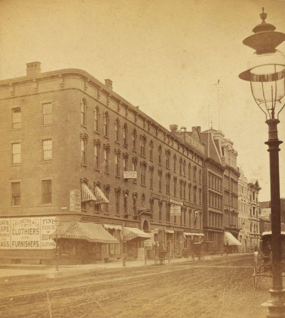
The Square at Bellows Falls, Vermont, around 1907. Image courtesy of the Library of Congress, Detroit Publishing Company Collection.
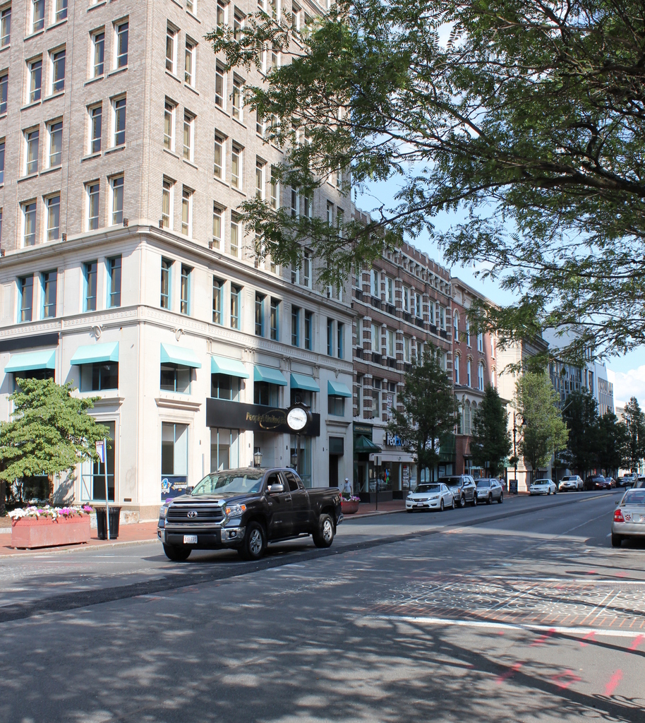
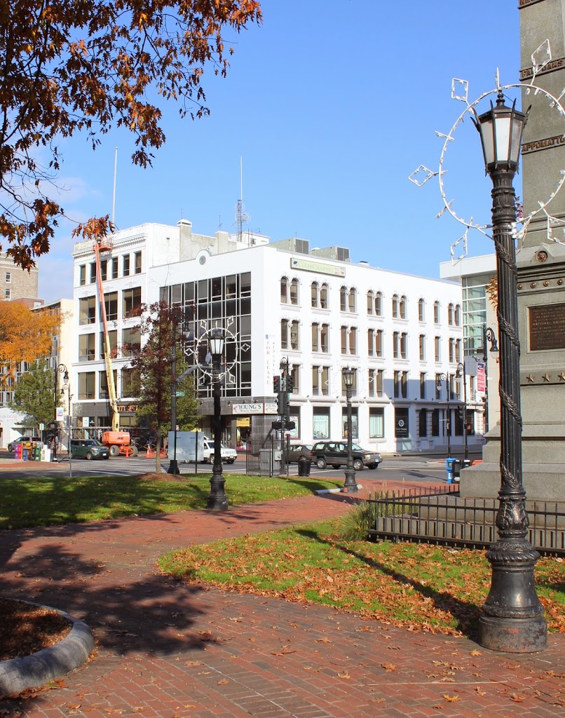
The scene in 2018:

The village of Bellows Falls is probably best known to baseball fans as the birthplace of Hall of Fame catcher Carlton Fisk, but historically it has been a significant settlement along the Connecticut River.  As the name implies, it is located at a waterfall on the Connecticut River, where the river passes through a narrow gorge.

The waterfall benefitted the village in several ways; first, the narrow width of the river made it easy to bridge.  In fact, the first bridge across the Connecticut River was built here in 1785, which made this a major transportation center, originally for stagecoaches and later for trains; it became a major railroad hub in the 19th century.  The falls also attracted many industries to Bellows Falls, and in the 19th century many industries developed along the river, powered by a canal that took advantage of the river’s 52-foot drop in elevation.

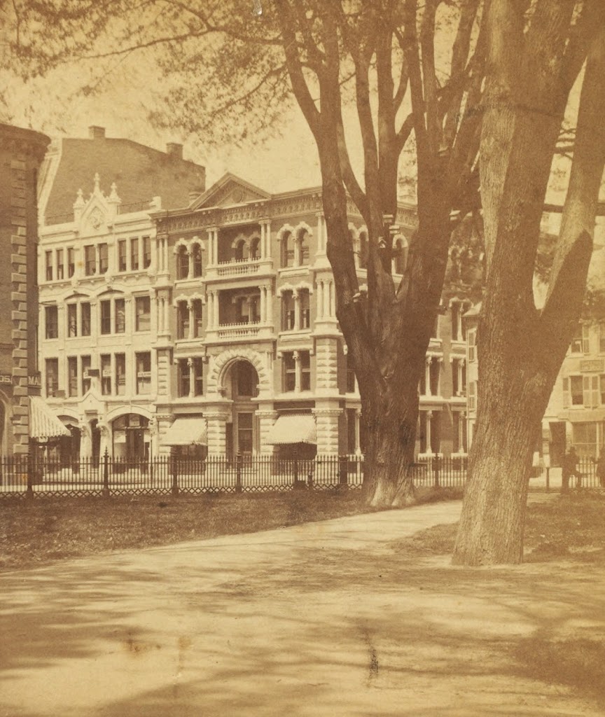
This scene shows the center of the village, much of which has changed in the past 108 years.  It retains its small-town appearance, but most of the buildings in the first photo have since been destroyed in a succession of fires, the first of which occurred in 1912 and destroyed several of the buildings on the right-hand side.  The two buildings just beyond the gabled brick building on the right date to the 1800s, but only the shells of the buildings survived the fire.  Closer to the camera on the right is the Hotel Windham, which was built in 1933 to replace the previous building, which burned in 1932.  On the left, the old post office and library, with its distinctive tower, burned in 1925, and was replaced with the present building the following year.

The only two surviving buildings on the square that are visible in both photos are the 1875 Centennial Block on the far left-hand side, which was itself damaged by a fire in 1978, and the wood commercial block in the distant center of both photos, which dates to around 1890 and is probably the only building in the 1907 photo that never had a fire.

Turnverein Block, Springfield, Mass

The Springfield Co-Operative Bank building at 81 State Street, Springfield, Mass, around 1938-1939. Photo courtesy of Springfield Preservation Trust.

415_1938-1939-2Bspt

The building in 2014:

415_2014

This building at 81 State Street was built in 1888 as the home of the Turnverein Society, a German-American social club.  In the 1920s, the façade was renovated in line with contemporary styles, although the rest of the building reveals the earlier architectural design.  By the time the first photo was taken, it was Springfield Co-Operative Bank, and the building continued to be used as a bank until at least the 1980s.  Today, the building is within the footprint of the planned MGM Springfield casino, and will be demolished, along with the tall annex to 1200 Main Street, which is seen directly behind the Turnverein Block.

Main Street from Court Square, Springfield, Mass

Several buildings along Main Street in Springfield, seen from across the street in Court Square, around 1865-1885. Photo courtesy of New York Public Library.

413_1865-1885c-2Bnypl

The view from Court Square in 2014:

413_2014

These photos were taken from Court Square from about the spot that Parsons Tavern once stood, before it was moved to the location in this post.  The massive elm tree in the first photo once stood right next to the building, and George Washington likely would’ve seen the tree upon his arrival nearly 100 years earlier.  Today, the tree is gone, but the street that it was named after – Elm Street – is still there.

The elm tree isn’t the only thing missing in the 2014 photo – the entire area across Main Street was cleared in the 1970s to build the MassMutual Center, a sports arena and convention center where the Springfield Falcons minor league hockey team plays.  According to the 1899 map of downtown Springfield, there were over 70 buildings within the modern-day footprint of the MassMutual Center, along with two streets, Market Street and Sanford Street.  Sanford Street can be seen in the opening between the buildings behind the elm tree, and once ran from Main Street to Dwight Street.

There are several identifiable businesses in the first photo; the white building on the left-hand side was the home of the First National Bank of Springfield, and just to the right of it is the storefront of Frank G. Tobey.  Tobey’s ad in the 1875 city directory indicates that he was a “Dealer in Hats, Caps, and Gent’s Furnishing Goods. Silk Hats made to order.”  Across Sanford Street, none of the signs on the storefronts are visible, but the buildings on that side appear to date to the early 1800s, with a style similar to the Byers Block on Elm Street just across Main Street, which survives today.

Union Block, Springfield, Mass

The corner of Main Street & Harrison Ave in Springfield, Mass, around 1878-1885.  Photo courtesy of New York Public Library.

412_1865-1885c-2Bnypl

The corner in 2017:


This view is very similar to the scene in this post, although the historic photo here is about 30 years older and shows just the buildings along Main Street from Harrison Ave to Court Street. As mentioned in the other post, the building in the foreground here is actually three buildings, which were constructed between 1858 and 1861, and came to be known as the Union Block.  The earliest section, furthest from the camera, is the Republican Block, and it was the home of the Springfield Republican newspaper from 1858 until 1867.  By the time the first photo was taken, it was the home of D.H. Bingham & Co. Clothing House, as seen on the massive sign atop the building.

The Republican Block is the only part of the Union Block that has survived relatively intact to this day.  The middle section, formerly home of Johnson’s Bookstore, is the original 1861 structure, but its facade was completely renovated in 1908 and does not retain any of its original architecture.

Closest to the camera, the northernmost third of the block was home of Kibbe Brothers Co., a large candy manufacturer in the city.  The Union Block was their home throughout the late 1800s, until they moved around the corner to a larger facility on Harrison Ave in 1890, which can be seen in this post.  This part of the Union Block was demolished in 1915, and replaced with the 10 story building that stands there today.

Bill’s Block, Springfield, Mass

Several buildings on the west side of Main Street in Springfield, Mass, near the corner of Bridge Street, sometime in the 1870s. Photo courtesy of New York Public Library.

410_1865-1885c-2Bnypl

The same location in 2017:


The New York Public Library estimates a date range of 1865 to 1885 for this photo, but a single sign on one of the buildings establishes that it had to have been in the 1870s.  The left-most storefront was home to W.D. Kinsman, a dry goods store that later moved a few buildings north in 1880, as seen in this post.  Other businesses visible on signs here include the Springfield Conservatory of Music, J. Wallach & Co., who sold hats, and F.S. Parmenter, another dry goods dealer.

Today, this site is still a major commercial center – the entire block is taken up by Tower Square, the second tallest building in the city.  People also still park along the side of the street, although instead of horses tied to hitching posts like in the first photo, there are cars parked next to meters.

Springfield Five Cents Savings Bank, Springfield, Mass

The view looking from Court Square toward the corner of Main and Court Streets, around 1878-1885. Photo courtesy of New York Public Library.

409_1865-1885c-2Bnypl

The scene in 2014:

409_2014

The ornate building in the center of the first photo is the Springfield Five Cents Savings Bank, which was built in 1876 at the corner of Main and Court Streets, diagonally across from Court Square.  The building is still there, although the Main Street facade was completely renovated at some point in the past 50 years or so.  However, the Court Street (today Falcons Way) facade is still largely intact, and reveals the fact that this building is not just another nondescript mid-20th century commercial building in the city.

Next to the Five Cents Savings Bank building in the first photo is the 1878 Republican Block, which was the home of the Springfield Republican newspaper.  I don’t know what happened to the building, but it apparently isn’t there anymore, unless it was renovated even more than its neighbor was.