Main Street, Brattleboro, Vermont (2)

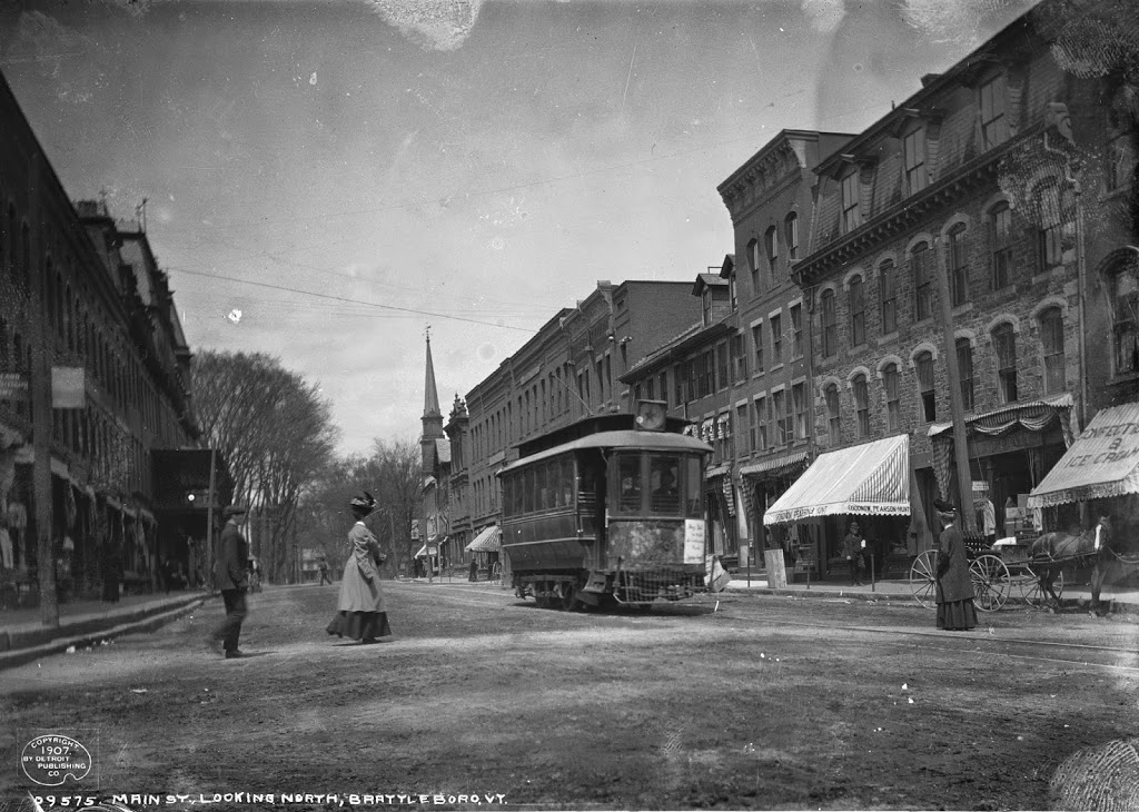
Looking up Main Street in Brattleboro from the corner of Canal Street, around 1907. Image courtesy of the Library of Congress, Detroit Publishing Company Collection.
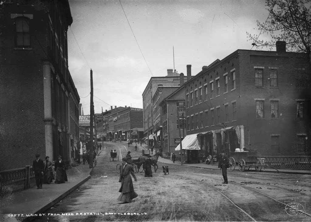
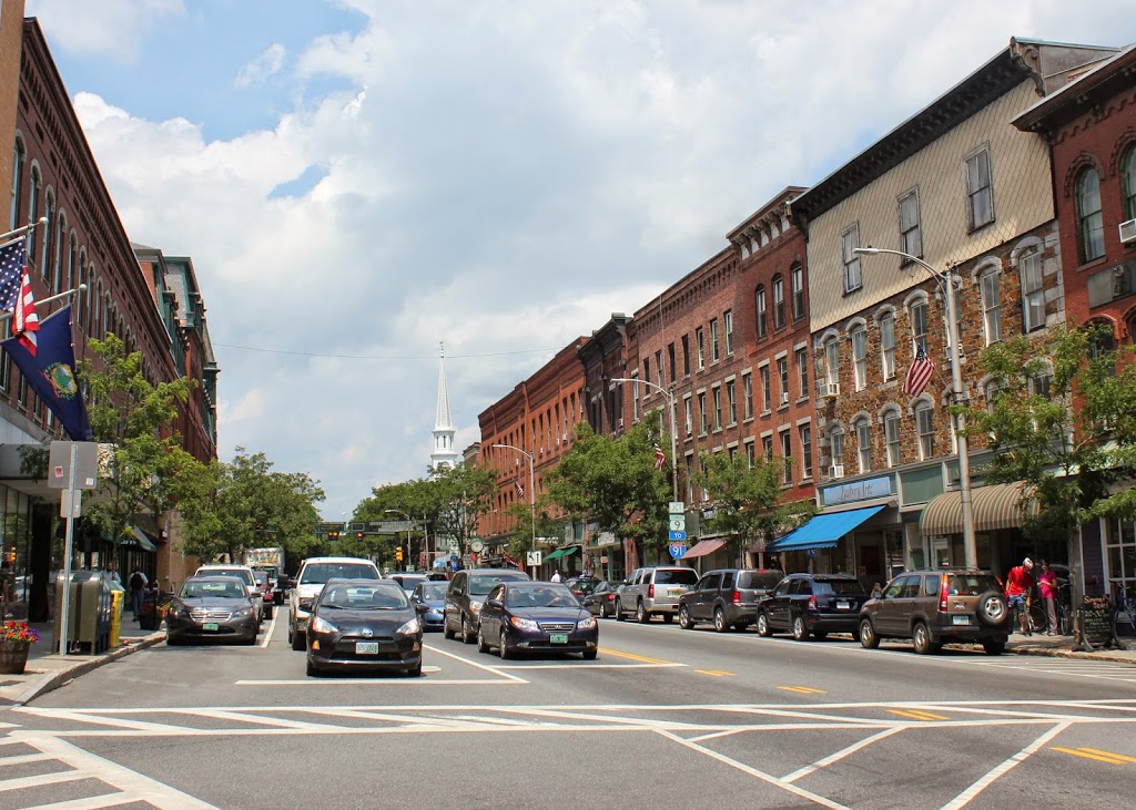
344_1907c-2Bloc

The scene in 2014:

344_2014

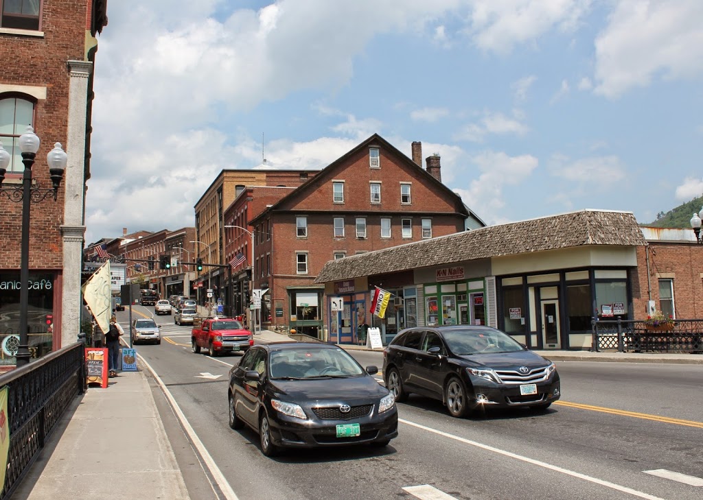
This view gives a good overview of the architecture on the east side of Main Street, very little of which has changed in the past century.  Many of the buildings were even fairly old when the first photo was taken, including the circa 1850 Van Doorn/Culver Block in the center of the 2014 photo.  Beyond it are several commercial blocks from around the turn of the century, and the oldest buildings are at the top of the hill and date to around 1840-1845, making them probably the oldest commercial buildings in downtown.  With the exception of the building on the right-hand side in the foreground of the 1907 photo, all of the buildings still exist today, forming part of the Downtown Brattleboro Historic District.

Main Street, Brattleboro, Vermont (1)

Main Street in Brattleboro, Vermont, looking north from Elliot Street around 1907. Image courtesy of the Library of Congress, Detroit Publishing Company Collection.

343_1907c-2Bloc

Main Street in 2014:

343_2014

The trolleys are gone, and there are a few more cars in the 2014 photo, but otherwise this scene hasn’t changed a whole lot.  It appears as though all of the buildings are still there, and for the most part the exteriors remain largely unaltered.  The only obvious exceptions are a couple with reconstructed fourth floors.  The field stone building on the far right (built around 1850) has had its elegant mansard roof replaced with some sort of architectural monstrosity that doesn’t even come close to matching the rest of the building.  Another building further down Main Street was built around the same time, and had its gabled roof replaced by a full fourth story around 1920, making it blend in with the rest of the street.

Seaver House, Boston

The Seaver House on the west side of Tremont Street across from Hollis Street, around 1882. Photo courtesy of Boston Public Library.

329_1800sc-2Bbpl

The scene in 2014:

329_2014

This view was taken from almost the same spot as the one in this post, which shows the scene before Tremont Street was widened.  Most of the buildings on Tremont Street in the 1882 photo above were built following the widening of the street, but none of them survive today. However, that doesn’t mean this neighborhood of Boston has completely changed.  It is part of Boston’s Theater District, a distinction that it held as far back as the 1800s.  In fact, the first photo is able to be dated to around 1882 based on the Fritz in Ireland playbill, which is posted on the wall on the far left-hand side of the first photo.  The wood-frame house in the left-center of the photo is the General Crane House, and was home to John Crane, a Boston Tea Party participant and Revolutionary War veteran.  By the time of the 1882 photo, it was home to the William Davis & Co. candy store.  Notice also the rails running through the cobblestone streets, and the blurred image of a horse-drawn trolley.  The trolleys would eventually be electrified and buried beneath Tremont Street in the late 1890s; today, the tunnel is still there, but it is no longer in service.

Franklin Street, Boston (2)

Looking down Franklin Street toward Arch Street from Hawley Street in Boston, around 1870. Photo courtesy of Boston Public Library.

327_1870c-2Bbpl

Franklin Street in 2014:

327_2014

Taken near the ones in this post, the first photo shows Franklin Street after the 1790s row-houses were demolished to make room for commercial development.  When the street was originally laid out, it included a landscaped terrace with a number of trees in the center of the road.  However, after the redevelopment, only a single tree remained, which is seen in the distance of the 1870 photo.  Within a couple years, however, the entire area would be destroyed in the Great Boston Fire of 1872, and the area was rebuilt again, with many of those buildings surviving today.

Franklin Street, Boston (1)

Looking down Franklin Street toward Arch Street from Hawley Street in Boston in 1858. Photo courtesy of Boston Public Library.

326_1858-2Bbpl

The same view down Franklin Street, between 1859 and 1872. Photo courtesy of Boston Public Library.

326_1850-1872c-2Bbpl

Franklin Street in 2014:

326_2014

Franklin Street in Boston was originally laid out in the 1790s by noted architect Charles Bulfinch, and included row-houses on both sides of a sweeping curve, as seen in the first photo. Known as the Tontine Crescent, this was an upscale neighborhood in the first half of the 19th century, but by the 1850s the city was expanding commercially. The row-houses were demolished, and replaced with the commercial buildings in the second photo. These didn’t last too long, though – they were destroyed in the Great Boston Fire of 1872. Today, it is still a major commercial center, part of the Downtown Crossing shopping district, but many of the buildings that are still standing along Franklin Street were the ones constructed in 1873 in the immediate aftermath of the fire. In addition, the street still retains its distinctive curve that was laid out over 200 years ago.

Niles Building, Boston

The Niles Building at the corner of School Street and City Hall Avenue in Boston, in 1880. Photo courtesy of Boston Public Library.

323_1880-2Bbpl

The same scene in 2014:

When the first photo was taken, School Street was home to Boston’s City Hall, which is barely visible on the far left-hand side.  The building, which opened in 1865, is still there, although it no longer functions as the City Hall.  The buildings in the foreground of the 1880 photo, however, are long gone – the building in the present-day photo was built in 1915, so the older buildings were obviously demolished before then.  At least one other building does exist today from the original photo – the Old Corner Bookstore is seen in the distance on the extreme right of the photo.