Public Garden, Boston

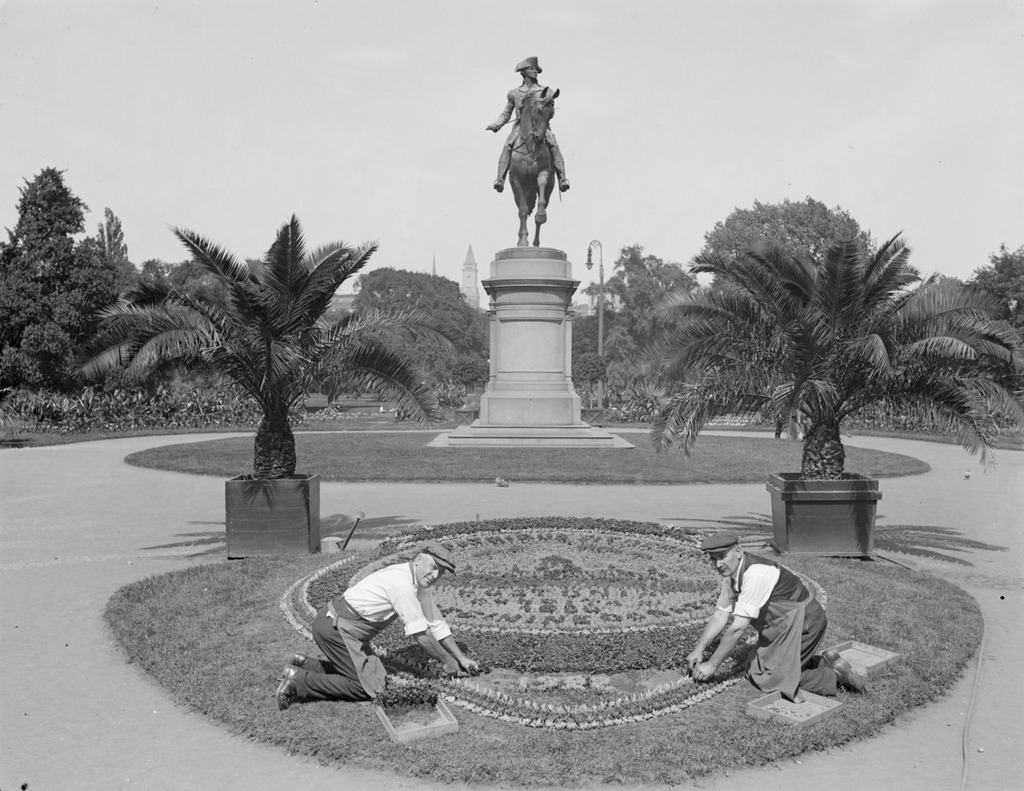
Looking east in the Public Garden from the Arlington Street entrance, facing the statue of George Washington, around 1917-1934. Image courtesy of the Boston Public Library, Leslie Jones Collection.

783_1917-1934c bpl

The view in 2015:

783_2015
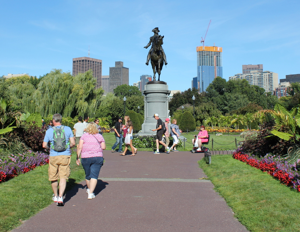
Boston Common was established in 1634 as the first public park in the country, and just over 200 years later, in 1837, the Boston Public Garden was created just to the west of it, as the first public botanical garden in the United States. The carefully-landscaped garden includes a pond, a bridge, a wide variety of plants, and several statues, including one of George Washington seen in these two photos.  The bronze statue has stood here since 1869, and it was designed by noted Boston sculptor Thomas Ball, whose other works include the Emancipation Memorial at nearby Park Square.

Some of the landscaping has changed at this entrance to the garden, and there are no floral arrangements like the one the men are working on in the first photo, but the most dramatic change in the past 80 or so years is the city skyline in the distance. When the first photo was taken, height restrictions prevented large skyscrapers from being built in the city, and the only one visible was the Custom House Tower, which, as a federal building, was immune to the city’s restrictions. Today, though, the restrictions are long gone, and Boston’s skyline continues to grow; the Millennium Tower, under construction to the right in the 2015 scene, will become the third-tallest in the city and the tallest in downtown when it is completed later in 2016.

North Main Street Cemetery, Monson, Mass

A view of the North Main Street Cemetery in Monson, probably around 1900-1920. Image courtesy of the Monson Free Library.

767_1890-1920c mfl

The cemetery in 2015:

767_2015
The area of present-day Monson was first settled in the early 1700s, but at the time it was part of the town of Brimfield.  Among other things, this meant that residents of this area had to bury their dead in Brimfield’s town cemetery, over six miles away from the current center of Monson. The 1960 History of Monson book quotes a petition signed by some of the area’s residents, complaining of “the Badness and length of ye way,” and pointing out that a more convenient burial ground would be of no harm, “it being no matter to the body where it lies when Dead.”  Their request was granted, but in any case the point was soon moot when Monson separated from Brimfield in 1760.

The town’s first large cemetery was established here, just a few hundred yards north of the meeting house.  The first burial was in 1777, and it was used until 1850, at which point the much larger Hillside Cemetery up the road became the town’s primary public cemetery.  Around 250 people were buried here, mostly in the first few decades of the 19th century.  The oldest headstones are carved of red sandstone or slate, and have survived the past few centuries in excellent condition.  The more recent white marble stones, though, have not weathered as well, and many of the inscriptions are no longer legible.

There has not been a burial here since about 50 years before the first photo was taken, but the cemetery is still well-maintained by the town, and it looks essentially the same as it did a century ago; some of the headstones are even still leaning in the same direction today.

Hillside Cemetery Arch, Monson, Mass

The arch at the entrance to Hillside Cemetery, at the corner of Main and Mill Streets in Monson, probably taken around 1900-1920. Image courtesy of the Monson Free Library.

766_1897-1920c mfl

The arch in 2015:

766_2015
The mid-1800s saw a major shift in the way cemeteries were designed.  Especially in larger cities, simple graveyards were replaced with elegant, landscaped cemeteries that felt more like a park than a place for burying the dead.  Mount Auburn Cemetery in Cambridge, just outside of Boston, helped to pioneer this idea in the 1830s, and soon major cities across the northeast were creating similar cemeteries.  Here in Monson, the town had its own scaled-down version of such cemeteries with Hillside Cemetery, which is seen in these two photos.  It is the final resting place for many of the town’s prominent citizens of the 19th century, many of whom had large family plots with ornate stones carved of Monson granite.

One of the defining features of Hillside Cemetery is this granite arch, which was built in 1897 with funds provided by Emma Field Page Norcross.  Although she lived in Germantown, Pennsylvania, she had the arch built in memory of her family members who are buried here, including prominent factory owner Cyrus W. Holmes.  Nearly 120 years later, the arch is still standing, and not much else has changed in this scene, aside from the increase in the number of headstones in the background.

Flynt Memorial Fountain, Monson, Mass

The fountain at the corner of Main and Fountain Streets in Monson, probably around 1900-1920. Image courtesy of the Monson Free Library.

764_1890-1920c mfl

The fountain in 2015:

764_2015
As mentioned in previous posts, the town of Monson became a significant industrial center in the 1800s. Most of this involved manufacturing textile products or straw hats, but the Flynt family built a prosperous business out of quarrying granite.  The company was started around 1825 by Rufus Flynt, and after his death in 1836, his son William took over the company at the age of 18.  Incidentally, the Flynts also had a connection to another prominent family in town.  William’s middle name was Norcross, which was his mother Sarah’s maiden name.  She was the daughter of William Norcross and the sister of Joel Norcross, whose house on Main Street is still standing today.  Joel was the grandfather of Emily Dickinson, which means William was her second cousin, once removed.

William N. Flynt remained in control of the company for the next 39 years, during which time it became one of the area’s leading producers of granite.  Monson buildings such as the Memorial Town Hall, St. Patrick’s Church, the Universalist Church, and the library were built of Flynt granite, as was the Hampden County Courthouse in Springfield along with many other public buildings in the northeast.

Shortly after his retirement, Flynt donated this fountain to the town.  It is located directly across the street from his company store, and it reads “Presented to the town by W.N. Flynt. 1882. Pro bono publico.”  The Latin phrase translates as “for the public good,” and in its early years this fountain served the public good as a watering trough for horses.  Given the marked decline in horse traffic on the streets of Monson, though, it has since been used as a decorative planter.

First Church, Monson, Mass

The First Church of Monson, probably around 1900-1920. Image courtesy of the Monson Free Library.

754_1890-1920c mfl

The church on June 3, 2011, two days after it was damaged in a tornado:

754_2011

The church in 2015:

754_2015
This view is similar to the one in this post, which shows the church from just a slightly different angle.  As mentioned in that post, the church was completed in 1873, and has been a major Monson landmark ever since. The steeple, though, has been replaced twice. The original one, seen in the first photo, was destroyed above the belfry in the 1938 hurricane.  It was reconstructed similar to the original design, but over 70 years later, the June 1, 2011 tornado completely destroyed the entire steeple, as seen in the second photo, which was taken two days later.  In the distance, the remains of the steeple lay in a pile of rubble in front of the church.  The old bell, which had been installed around 1881, was also cracked and had to be replaced.  The steeple was rebuilt in 2013, using stronger building materials of concrete, steel, and fiberglass. Other than the new materials, though, it is identical to the 1939 reconstruction.

Portland Head Light, Cape Elizabeth, Maine (3)

Another view of Portland Head Light, probably taken around the 1870s. Image courtesy of the New York Public Library.

741_1865-1883c nypl

The lighthouse in 2015:

741_2015
The first photo here was probably taken around 10-20 years before the ones in the previous two posts here and here, and it shows the tower as it appeared following its 1865 height change.  As mentioned in more detail in the first post, the lighthouse was built in 1791, but was reduced in height by 20 feet in 1812, to the spot below the lantern where a horizontal band runs around the tower.  Those 20 feet were restored in 1865, as seen in the first photo, but the tower was trimmed down again in 1883.  Just two years later, though, enough sailors complained that it was raised 20 feet yet again, with changes such as a larger lantern room at the top and  a second gallery below it.  Since 1885, it hasn’t seen very many changes, and it remains an active lighthouse as well as a popular tourist destination along the southern coast of Maine.