Old City Hall, Boston

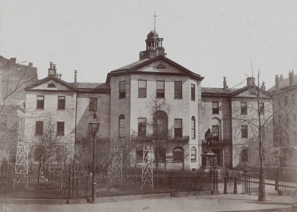
Johnson Hall, which served as a courthouse and later as City Hall, on School Street around 1855-1862. Image courtesy of the Boston Public Library.

691_1855-1862c bpl

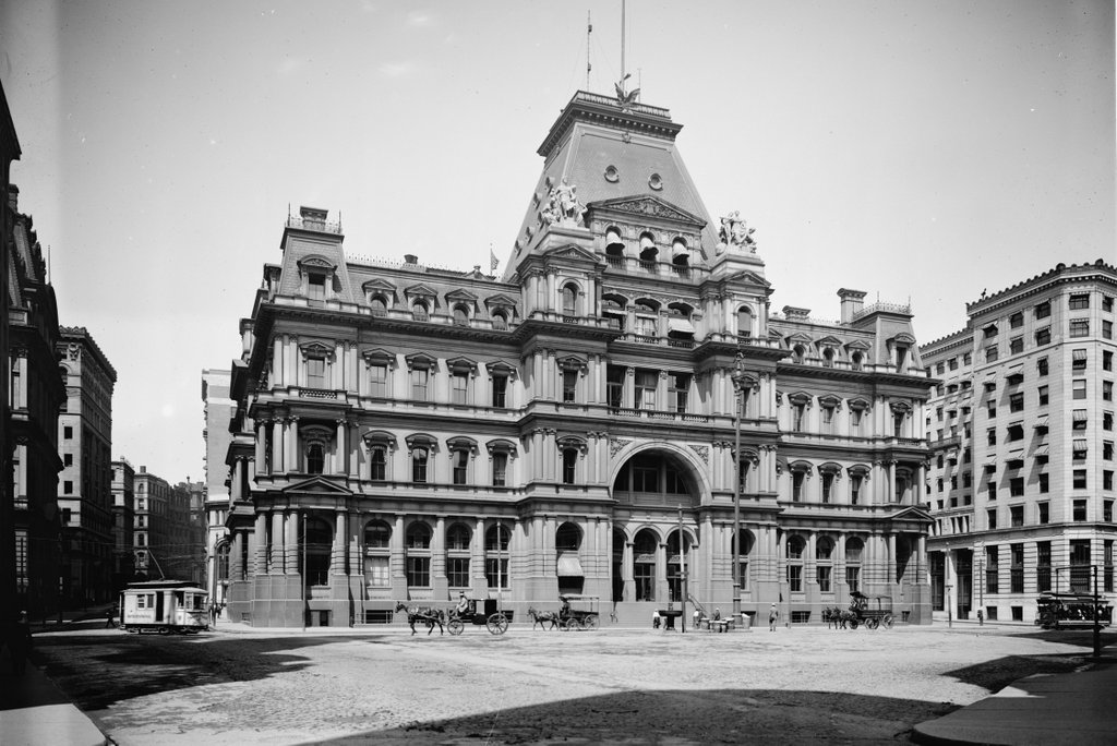
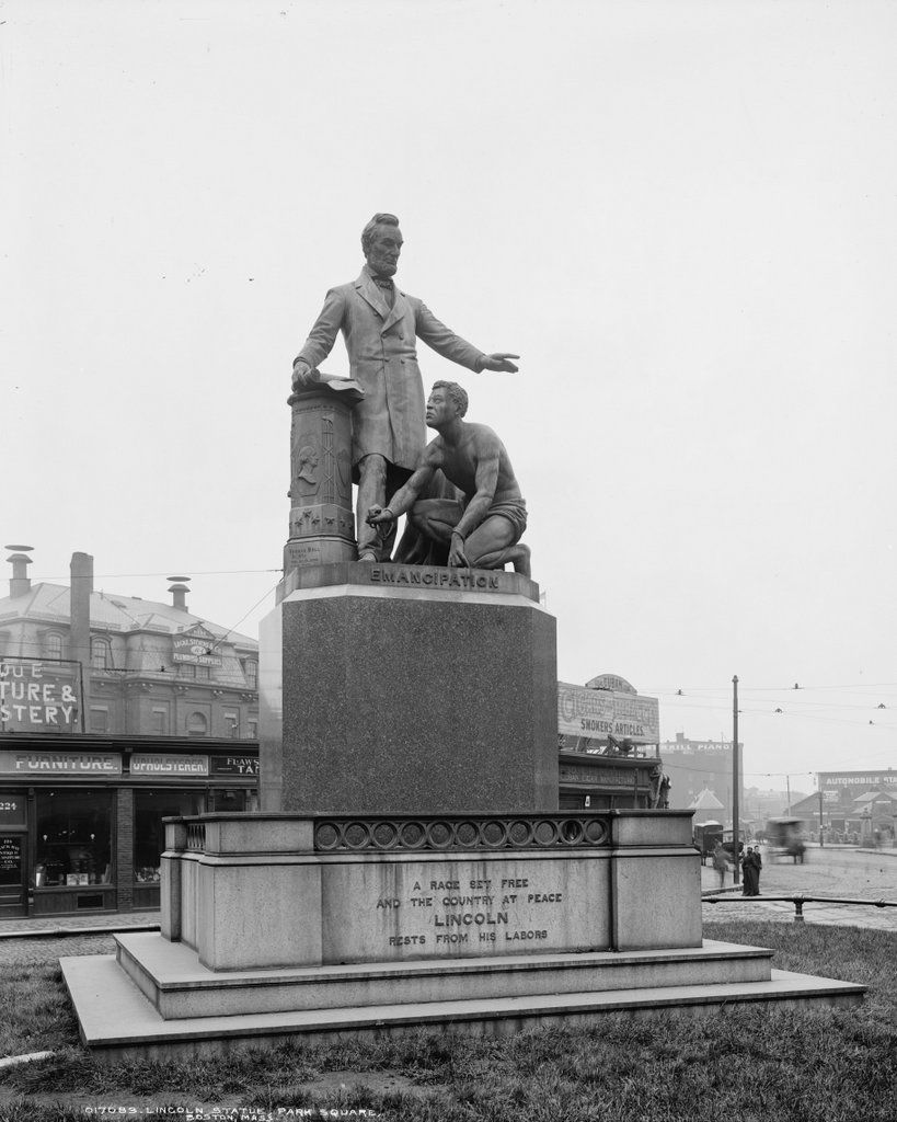
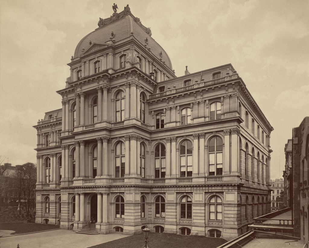
Boston’s old City Hall, which replaced Johnson Hall, as seen in 1865. Image courtesy of the Boston Public Library.

691_1865 bpl

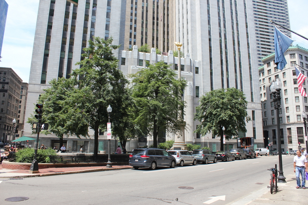
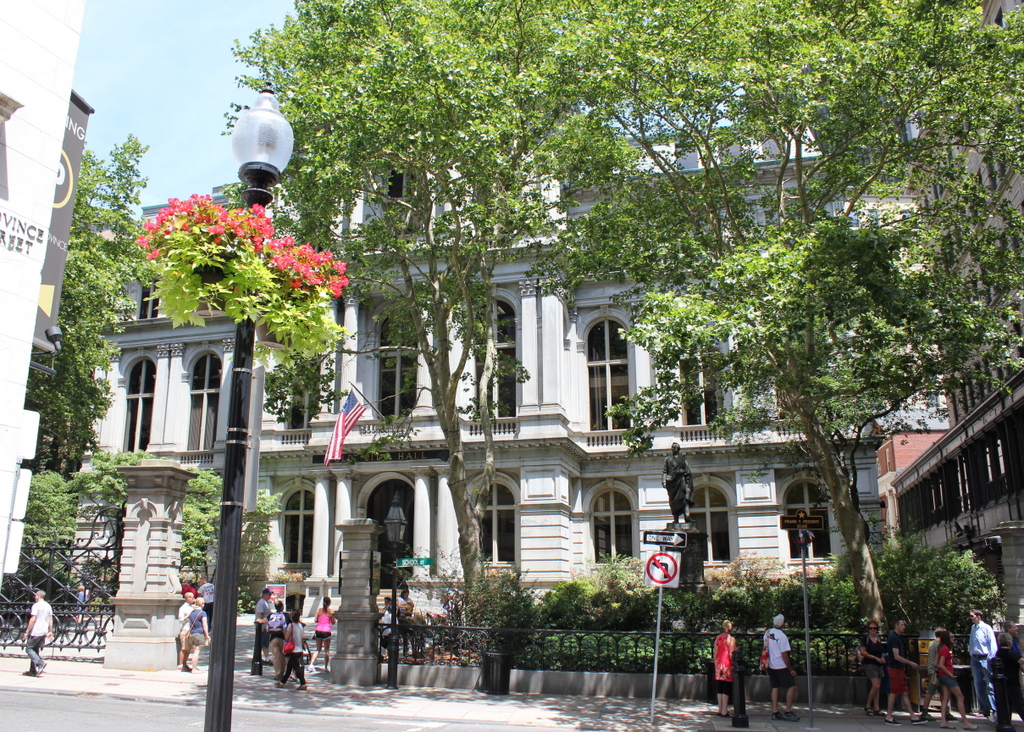
Old City Hall in 2015:

691_2015
This site on School Street has had two different City Hall buildings, as seen in the photos above, but the history here goes back even further.  From 1704 to 1748, Boston Latin School was located here, and during this time many of the Founding Fathers attended the school, including Benjamin Franklin, John Hancock, Samuel Adams, and Robert Treat Paine.  Years later, Charles Bulfinch designed a courthouse that was built here in 1810; this building, which is shown in the first photo, was used as both a county and federal courthouse in the early 19th century.  From 1841 until 1862, it was Boston’s City Hall, before being demolished and replaced with a newer, larger building.

The new City Hall was completed in 1865, and was one of the first examples of Second Empire architecture in the United States.  This French-inspired style would become very popular in the late 1860s and 1870s, especially in government buildings.  Boston’s old post office, which was built a decade later and just a few blocks away, shares many similar features.  On a much larger scale, the Old Executive Building next to the White House in Washington, DC also reflects the influence of Second Empire designs.

During its time as City Hall, this building saw the rapid growth in the city during the late 1800s and early 1900s.  When it was completed, the city had fewer than 200,000 people, but by the 1950s there were over 800,000, and the city government had long since outgrown this building.  The City Hall Annex, located behind this building on Court Street, was built in 1912 to accommodate more offices, but by the 1960s the city was looking to build a new City Hall.  The current building was completed in 1968, and since then the old building has been extensively renovated on the inside for commercial uses, but the exterior is essentially unchanged from 150 years ago.

Post Office, Boston

The old post office at Post Office Square in Boston, around 1906-1920. Image courtesy of the Library of Congress, Detroit Publishing Company Collection.

690_1900-1920c loc

The scene in 2015:

690_2015
The triangular intersection of Congress, Pearl, and Milk Streets has been known as Post Office Square since 1874, with the completion of the post office seen in the first photo. The square was actually the result of the Great Boston Fire of 1872, which destroyed most of the buildings around the post office, which was under construction at the time.  The small park is still there, although most of the buildings around it have changed.

The old post office was demolished to build the John W. McCormack Post Office and Courthouse, which was completed in 1933 and is still standing today.  It features Art Deco architecture, and at 22 stories and 600,000 square feet it is substantially larger than its predecessor.  It was added to the National Register of Historic Places, and it is still used as a federal courthouse, post office, and federal office building.  Just to the right of it is the former National Shawmut Bank Building, which was built in 1906 and can be seen in both photos.  At least one other building from the first photo, the 1893 International Trust Company Building, is still standing today; it is visible in the distance on the left, at the corner of Devonshire and Milk Streets.

Boston and Maine Station, Boston

The Boston and Maine Railroad station at Haymarket Square in Boston, around 1894. Image courtesy of the City of Boston Archives.

689_1894c coba

The Boston City Hospital Relief Station, on the site of the former railroad station in 1905. Image courtesy of the City of Boston Archives.

689_1905-11-05

The location in 2015:

689_2015
Of the eight major railroads that served Boston in the late 1800s, the Boston and Maine came the closest to the downtown area, with its depot at Haymarket Square. It was opened in 1845, and over the years Boston and Maine became the dominant railroad in northern New England, with many of its lines converging here.  However, because there were four different railroads that had their own stations within a few blocks of here, the companies built North Station in 1893, about 300 yards up Canal Street from here.

The old station had been built in the early years of railroad travel, and it stood until 1897, when it was demolished to make way for a new type of rail travel.  Boston’s Tremont Street Subway was the first subway tunnel in the country, and the northern entrance of the tunnel was built on the site of the station.  From here, the tracks ran along the surface between Canal and Haverhill Streets, where the station platforms used to be.  The only new building on the site was the Boston City Hospital Relief Station, as seen in the 1905 photo.  It was built in 1902 as a branch of the Boston City Hospital, in order to provide emergency services in the downtown area, and it stood until the early 1960s.

Today, there isn’t much left from either of the first two photos.  A few of the buildings on Canal Street are still standing, such as the one on the far left in both the 1891 and 1905 photos.  It is barely visible on the left of the 2015 photo, above the bus in the foreground.  Haymarket Square itself is completely changed, though, through a series of urban renewal projects in the 20th century.  To the left is a parking garage, with the Haymarket Square subway station underneath it.  On the right-hand side of the photo, the elevated Central Artery once passed through here.  Built in the 1950s, it cut a swath through downtown Boston until 2003, when the highway was rerouted through the Tip O’Neill Tunnel as part of the Big Dig.  The building under construction in the background is being built on land that the Central Artery once passed through.

North Station, Boston

The original North Station on Causeway Street in Boston, around 1893-1899. Image courtesy of the Library of Congress, Detroit Publishing Company Collection.

688_1890-1899c loc

The scene in 2015:

688_2015
Oliver Wendell Holmes once wrote about Boston as being “The Hub of the Solar System,” and although he was using the phrase sarcastically, the city would soon become the transportation hub of New England.  By the late 1800s, there were at least eight railroads that radiated outward from Boston, with each one having its own separate terminal.  However, these eight different stations were both inconvenient for passengers and also a poor use of valuable land.

Here in the northern part of the city, four different railroads each had their own stations within a several block radius: the Boston and Maine, Boston and Lowell, Eastern Railroad, and the Fitchburg Railroad.  All but the Boston and Maine had their passenger terminals in a row here along Causeway Street, so in 1893 the North Union Station opened here, consolidating all four railroads into one building.  It was designed by Shepley, Rutan and Coolidge, a prominent Boston architectural firm that would design South Station six years later, when the four south side terminals were likewise consolidated.

The original North Station was demolished in 1927 to build the Boston Garden, which also included a reconstructed station.  Boston Garden was home to the Boston Bruins from 1928 to 1995, and the Boston Celtics from 1946 to 1995, and the it was demolished in 1998, three years after the completion of the present-day TD Garden.  Today’s North Station is located directly underneath the TD Garden, although today none of the four railroads that opened the first station even exist anymore.  Amtrak has only one passenger route, the Downeaster, that stops here, although it is the terminal for four of the MBTA Commuter Rail lines.  Above the station, the Bruins and Celtics still play here, just behind the spot where the Boston Garden once stood.

Boylston Station, Boston

The Boylston subway station, at the corner of Tremont and Boylston Streets in Boston, on August 12, 1897. Image courtesy of the City of Boston Archives.

687_1897-08-12 coba

The station in 2015:

687_2015
The first photo captures the ending of one era and the beginning of another.  Just a few weeks after the photo was taken, the trolleys that are seen here on congested Tremont Street would be moved underground, giving Boston the distinction of having the country’s first subway tunnel.  The first two stations were Park Street, just over a quarter mile to the north, and this one here at Boylston Street, in the southeast corner of Boston Common.  The project was a major civil engineering milestone, but it didn’t come without tragedy.  At this location earlier in the year, a leaking gas line in the work area under the intersection caused an explosion that killed six people.  The explosion is explained further in this post, which features photos that were taken diagonally across the street from here.

Today, the view really hasn’t changed too much.  The trolleys on the Green Line are still running under this intersection, the distinctive station entrances are still here, as is Boston Common in the background.  Even in the 19th century, this intersection of Boylston and Tremont streets was busy, necessitating the police officer in the left center of the 1897 photo.  The slow shutter speed of the camera has blurred most of the traffic around him, but he is standing perfectly still, posing for the photographer as trolleys, carriages, and pedestrians pass by.  It is still a major intersection today, albeit without the nostalgia of a 19th century officer directing traffic on a cobblestone street.

Emancipation Memorial, Park Square, Boston

The Emancipation Memorial at Park Square, photographed around 1900-1906. Image courtesy of the Library of Congress, Detroit Publishing Company Collection.

686_1900-1906c loc

Park Square in 2015:

686_2015
This statue at Park Square is a copy of the original Emancipation Memorial at Lincoln Park in Washington, D.C., which was designed by Charlestown, Massachusetts native Thomas Ball and dedicated in 1876.  Designed to memorialize Abraham Lincoln and his role as the “Great Emancipator,” it shows Lincoln standing over a slave who is kneeling in front of him, with shackles on his wrist.  The original was paid for entirely by donations from freed slaves, but it has not been without controversy.  At the dedication ceremony, Frederick Douglass was reported to have criticized the slave’s position on his knees, and more recent historians have also objected to his seemingly inferior position in front of Lincoln.

Boston’s copy of the statue was donated to the city in 1879 by local politician Moses Kimball.  It has a different pedestal than the Washington one, which reads “A race set free and the country at peace Lincoln rests from his labors.”  The statue’s appearance has changed very little over the years, except for the planters at each corner.  However, the surrounding neighborhood has completely changed. The buildings behind the statue in the first photo show signs for a plumbing supply company, furniture upholsterers, and even Cuban cigars, over 50 years before they were outlawed.  On the extreme right is one of the buildings from the former Boston and Providence Railroad depot, which closed a few years earlier when the railroad was rerouted to South Station. Today, the Boston Park Plaza Hotel, which was built in 1927 and is just out of view in the 2015 photo, stands on the site of the former depot.