Railroad Station, East Longmeadow Mass

The railroad station near the center of East Longmeadow in 1910. Photo courtesy of the East Longmeadow Historical Commission.

476_1910-03-14 elonghistcom

The station in 2015:

476_2015

The station in 2023:

Today, East Longmeadow doesn’t have any active rail lines, but a century ago the Armory Branch of the New York, New Haven & Hartford Railroad passed through the town.  The line connected East Hartford and Springfield, and passed by the Watershops of the Springfield Armory, which gave the branch its name.  In East Longmeadow, it provided a way for the many quarries in town to ship their stone, and it also provided a method of transportation in the days before automobiles.  However, the branch was never a major route, and was abandoned by the 1980s.  Today, most of the line is still abandoned, but a 1.6 mile section in East Longmeadow is now the Redstone Rail Trail, named for the quarries that once used the line.  The station, which opened in 1876, is located at the northern terminus of the trail, and although it has clearly seen better days, it is still instantly recognizable from the 1910 photo.

2023 Update: As shown in the third photo, station has since been restored, and it reopened in 2021 as an ice cream shop.

Timothy Merrick House, Wilbraham Mass

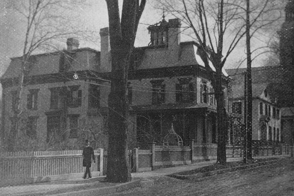
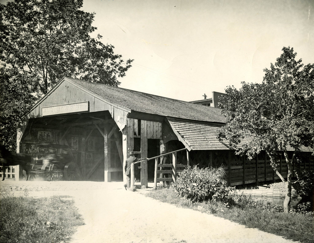
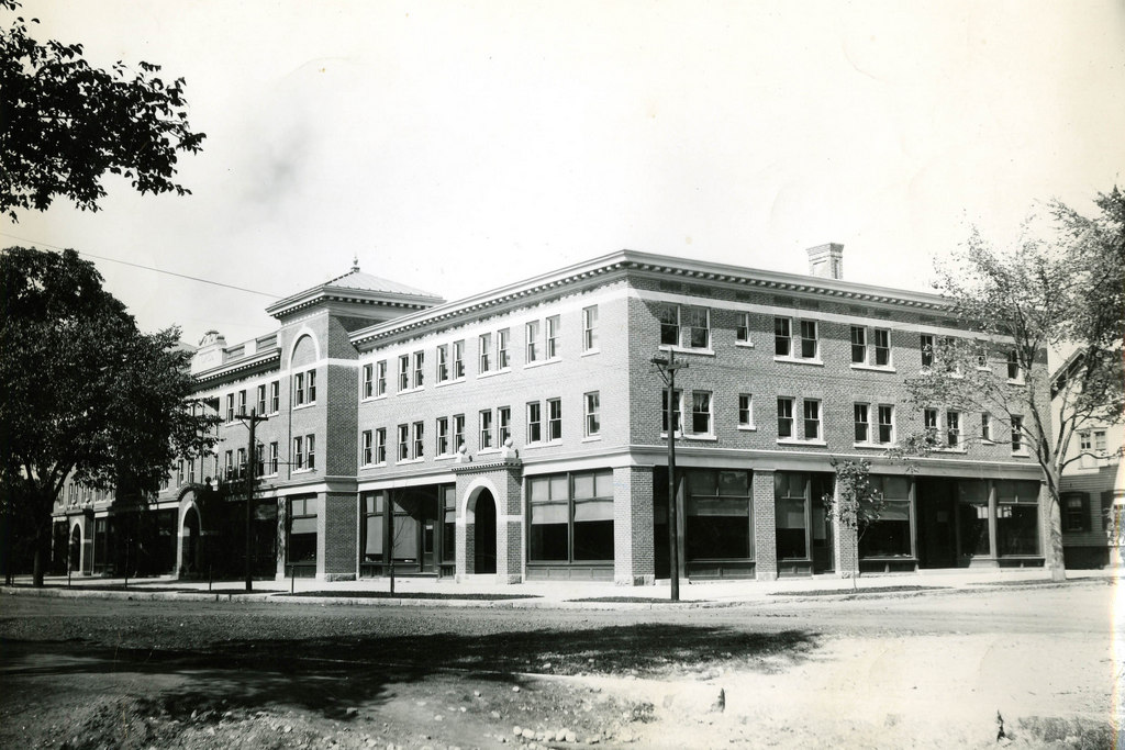
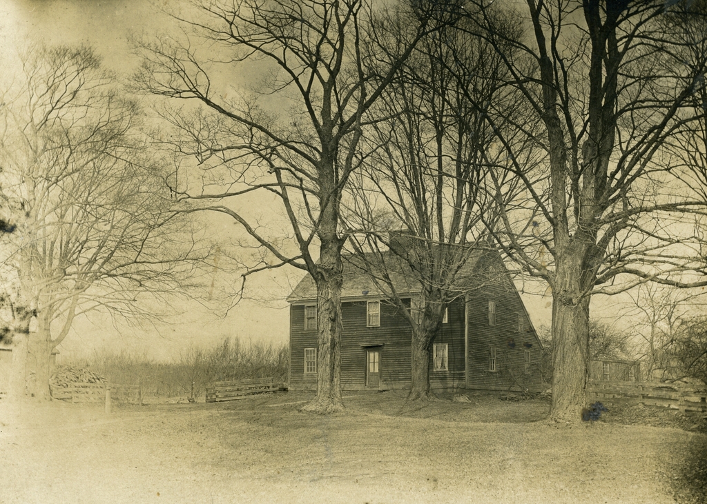
The Timothy Merrick House on Main Street in Wilbraham, probably sometime in the late 1800s. Photo courtesy of the Wilbraham Public Library.

475_1800sc wpl

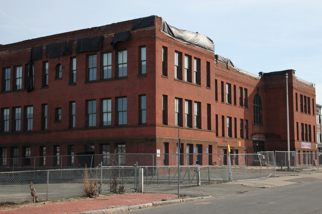
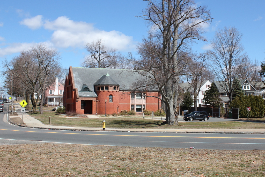
The same location in 2015:

IMG_2492


Massachusetts is home to only two species of venomous snakes: the timber rattlesnake and the northern copperhead.  Both are exceedingly rare in the state, but they must have been more common in Wilbraham in the past, as they make several appearances into town lore. This house was built around 1761 for Timothy Merrick, the only son of my 6th great grandfather, Thomas Merrick.  Merrick was engaged to Sarah Lamb, and they were to live in this house after their marriage.  However, according to the records of the town clerk, Samuel Warner (who was also my 6th great grandfather, from a different branch of the family):

Timothy, son of Thomas Mirick and Mary Mirick, was Bit By a Ratel Snake one Aug. the 7th, 1761, and Dyed within about two or three ours he being twenty two years two months and three Days old and vary near the point of marridge.

Merrick’s death is believed to be the last recorded fatal snake bite in Massachusetts history, but even if not it is certainly the most famous.  Because of the tragic nature of the story, this event formed the basis for one of the earliest American ballads, “On Springfield Mountain.”  It was written in the late 1700s or early 1800s, and there are many different versions of this song, some of which include a number of embellishments beyond what Warner wrote in the town records.  One such version, recorded in the 1964 History of Wilbraham book, is asserted to be the original Merrick family version:

On Springfield Mountain there did dwell
A likely youth was known full well
Lieutenant Mirick’s only son
A likely youth nigh twenty one

One Friday morning he did go
Into the medow for to mow
A round or two and he did feel
A pisin sarpent at his heel

When he received his deadly wound
he dropt his sithe apon the ground
And strate for home was his intent
calling aloude still as he went

O Molly Molly Molly dear
come see this pesky sarpent here
Tho all around his voice was heered
none of his friends to him apiered

So soon his carful father went
to seek his son with discontent
And there his onley son he found
ded as a stone apon the ground

His father vieude his track with consarn
where he had rund across the corn
Uneven tracks where he did go
appeared to stagger to and fro

And there he lay suppose to rest
with both his hands acrost his brest
His mouth and eyes were closed fast
and there poor man he slept his last

The seventh of August sixty one
this fatal axsident was done
let this a warning be to all
to be prepared when God doth call.

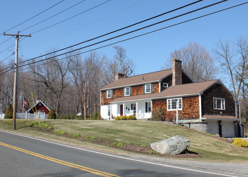
Today, as seen in the second photo, Timothy Merrick’s house is gone; it burned in 1955 was was replaced soon after with a modern house.  The location of the snake bite has not been conclusively identified, but it was across Main Street and a little to the south of the house, which would place it right along the present-day Hampden-Wilbraham border.  This area is now a suburban residential development, and the History of Wilbraham book places the location at around the spot where Oakland Street crosses a small stream.  Although both the house and the farmland that Merrick was once mowing are now gone, there are still a few reminders around town.  Behind the location of the Merrick house is the Pesky Sarpent Conservation Area, and further up the hill is a rocky outcropping called Rattlesnake Peak.  Timothy Merrick’s gravestone can also still be seen, in the Adams Cemetery on Tinkham Road.  There is no direct mention of the rattlesnake on the stone, but the epitaph, taken from Job 14:2, seems appropriate for the sudden, tragic death of a young man: “He cometh forth like a flower and is cut down.  He fleeth also as a Shadow and continueth not.”

Charles Merriam House, Springfield, Mass

The former Charles Merriam house at 61 Howard Street in Springfield, around 1892. Photo from Picturesque Hampden (1892)

474_1892c picturesquehampden

The location in 2015:

474_2015

This house on Howard Street was built around the 1830s, and was the home of Charles Merriam. He and his brother Charles had grown up in West Brookfield, but in 1831 they moved to Springfield and, the following year, opened a publishing company called G. & C. Merriam. A few years later, the Merriams purchased the rights to Noah Webster’s dictonary, which turned out to be a wise business move. Merriam-Webster, as the company is now known, is still headquartered in Springfield, and their famous dictionary is still being published today.

Charles married his first wife, Sophia Warriner, in 1835, and the couple had five children. She died in 1858, and two years later he remarried to Rachel Capen, a 36 -year-old widow. They continued living here in this house, and Rachel became involved in charitable efforts in the city, which included being one of the founders of the Home for Friendless Women. It was established in 1865 with Rachel as its first president, and provided shelter and services for needy women and children.

The original building for the Home for Friendless Women was located on Union Street, essentially in the Merriams’ backyard. Within a few decades it was too small to meet the growing needs, though. Shortly after Charles’s death in 1887, Rachel donated the home to the organization, who was using it by the time the first photo was taken. However, within a few years they built a new building on William Street, and the Howard Street property was sold.

By the 1890s, Howard Street was hardly the upscale residential street that it had once been when Charles Merriam moved in more than 60 years earlier. The 1900 census shows that the street was predominantly French-Canadian, a fact emphasized by the presence of St. Joseph’s Church, a French Catholic church visible in the extreme right of the first photo. The former Merriam house was at this point owned by Napoleon Byron, a French-Canadian undertaker who lived here with his wife Emily, their seven children, and three boarders.

The old house did not remain here for much longer, though. It was demolished by 1905, when the Howard Street School was built to serve the growing population of the South End.  This school later became the Zanetti School, and was used up until 2009.  Two years later it sustained significant damage in the tornado that passed through Springfield, and as of April 2015 it is scheduled to be demolished, pending final approval from the state historical commission.  The current MGM Springfield casino plans call for the construction of a parking garage on the spot of the school.

Put’s Bridge, Springfield Mass

The old covered bridge across the Chicopee River from Springfield to Ludlow, taken from the Springfield side in 1897. Photo courtesy of the Hubbard Memorial Library.

473_1897 hubbardmemlib

The present-day bridge in 2015:

473_2015

Alternately called Putts Bridge, this spot at Wallamanumps Falls on the Chicopee River has long been the site of a bridge connecting Springfield and Ludlow.  The early accounts are somewhat vague, but the first bridge was built in either the late 1780s or early 1790s.  Either way, a bridge was definitely here by 1794; prior to that, Ludlow’s 500 or so residents would have to get to and from Springfield by fording the river, a task that I can’t image was particularly pleasant or safe.  The bridge was constructed by Eli Putnam, hence the name Put’s bridge.  However, bridges here didn’t seem to have much of a lifespan; in the next 30 years, three additional bridges would have to be constructed on this site.

The 1822 bridge must have been different, because it lasted until this 1897 photograph.  By this point, though, the 75 year old bridge was starting to show its age, and the next year it was replaced with a new iron bridge.  However, the replacement didn’t even last half as long as its predecessor before it was replaced by the current bridge in 1930.  Today, this concrete and steel bridge carries Route 21 across the river, and it still serves as the primary connection from Ludlow to Springfield.  The one difference in the location of these two photos is that the covered bridge was at a substantially lower elevation, so the 1897 photo would’ve actually been taken partway down the hill toward the river.  I could’ve recreated the scene from here, but I chose this location since it represents what the surface of bridge today looks like, rather than just the underside of it.

Hubbard Memorial Library, Ludlow Mass

Hubbard Memorial Library in Ludlow, seen in 1903. Photo courtesy of the Hubbard Memorial Library.

472_1903 hubbardmemlib

The library in 2015:

472_2015

Ludlow’s current public library building was built in 1889 as a gift to the town from the estate of the late industrialist Charles Townsend Hubbard, the founder of the Ludlow Manufacturing Company.  Hubbard may not have been as prolific a library builder as fellow 19th century industrialist and philanthropist Andrew Carnegie (who funded 2,509 libraries to Hubbard’s 1), but he played a significant role in expanding the selection of books available to Ludlow’s citizens, many of whom worked in his factory.  The first public library in Ludlow opened in 1881 with around 400 books, but when the building opened in 1889 the town accepted a donation of 1,500 books from the Ludlow Manufacturing Company.  By 1912, the library’s holdings were around three to four thousand.

As time went on, the interior was altered to provide adequate room for the growing collections, although today the exterior looks essentially unchanged from the 1903 scene.  This is probably in part due to one of the stipulations in the original agreement to accept the building from the Hubbard estate, that “the building is to be forever maintained in proper repair at the expense of the town as a public library and reading room.”  I don’t know exactly how enforceable a “forever” clause is in this case, or what would happen if the town did decide to move the library, but stipulations aside, it is a historically and architecturally significant building that has become a Ludlow landmark, so I doubt it would be going anywhere anytime soon.

Old Post Office Block, Ludlow Mass

The Old Post Office Block at the corner of East and Sewall Streets in Ludlow in 1903. Photo courtesy of the Hubbard Memorial Library.

471_1903 hubbardmemlib

The building in 2015:

471_2015

These views were taken from about the same spot as the ones in this post, just turned a little further to the right.  The building here is the old Post Office Block, which was built in 1901, and not surprisingly housed the Ludlow Post Office for nearly 60 years.  Although Ludlow’s original town center is further away, this area along the Chicopee River grew in population in the late 1800s thanks to the factories that developed here in Ludlow and across the river in Indian Orchard.  Many of the postal customers of the early 1900s would have been workers across the street at the Ludlow Manufacturing Associates factory; some of the buildings from this facility still exist today, including the iconic clock tower directly behind where this photo was taken.

This building wasn’t just a post office though; it also had other commercial tenants, and it was one of the first large commercial buildings in the town.  The size of the building reflected the dramatic spike in population; between 1890 and 1900, Ludlow’s population nearly doubled, and would more than double again by 1920.  The post office hasn’t used the building in over 50 years, but it remains in a remarkable state of preservation 112 years later.