Main Arsenal, Springfield Mass

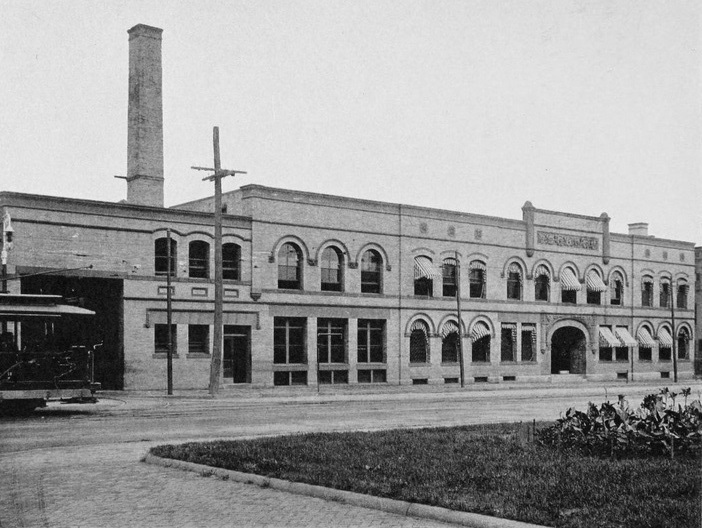
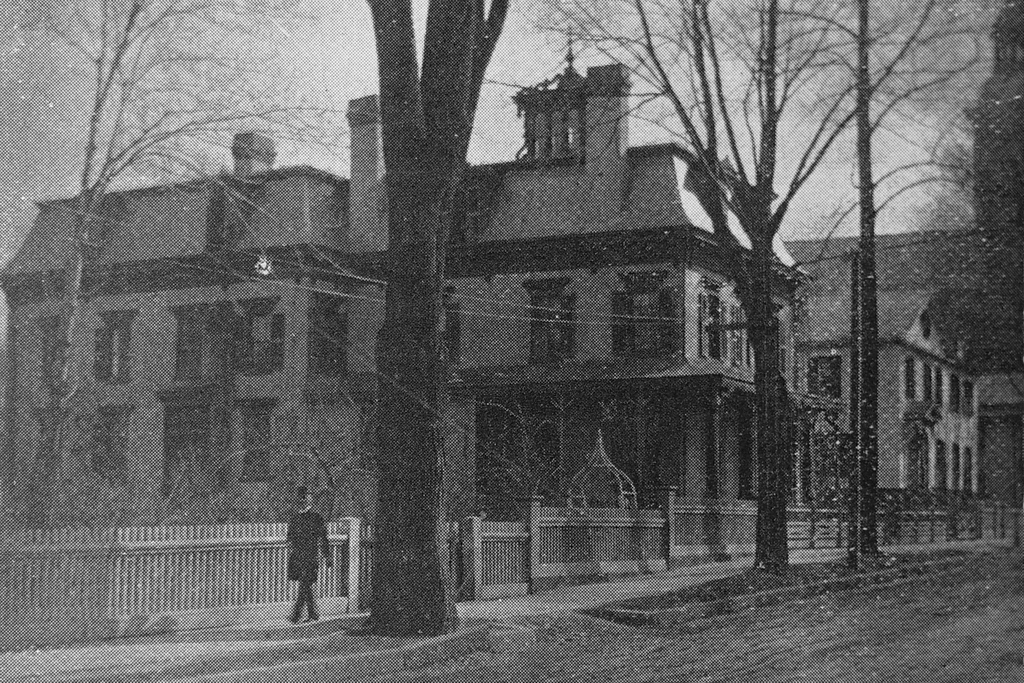
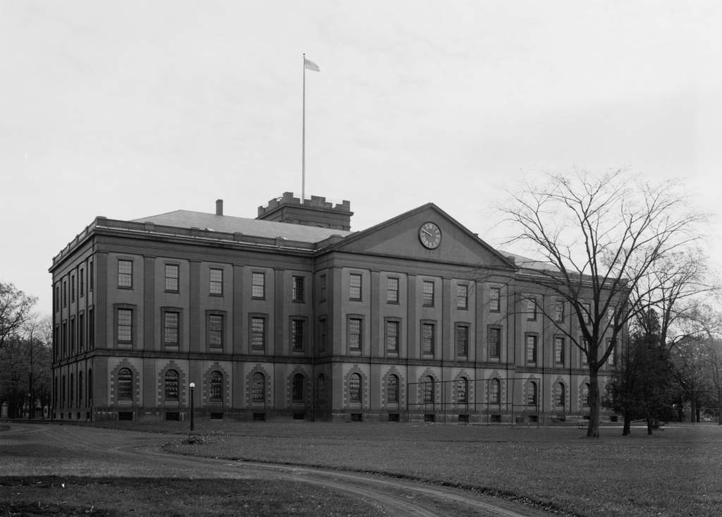
The Main Arsenal at the Springfield Armory, seen around 1910-1920. Photo courtesy of the Library of Congress, Detroit Publishing Company Collection.

481_1910-1920 loc

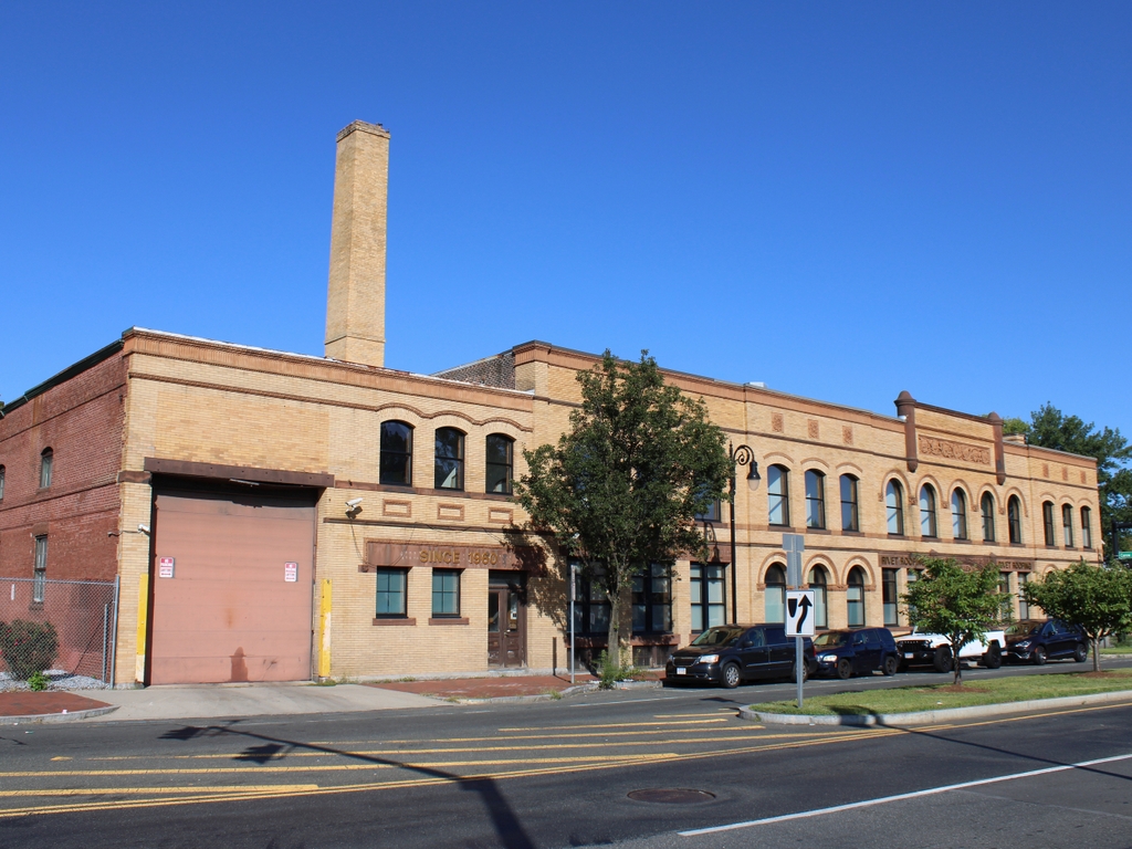
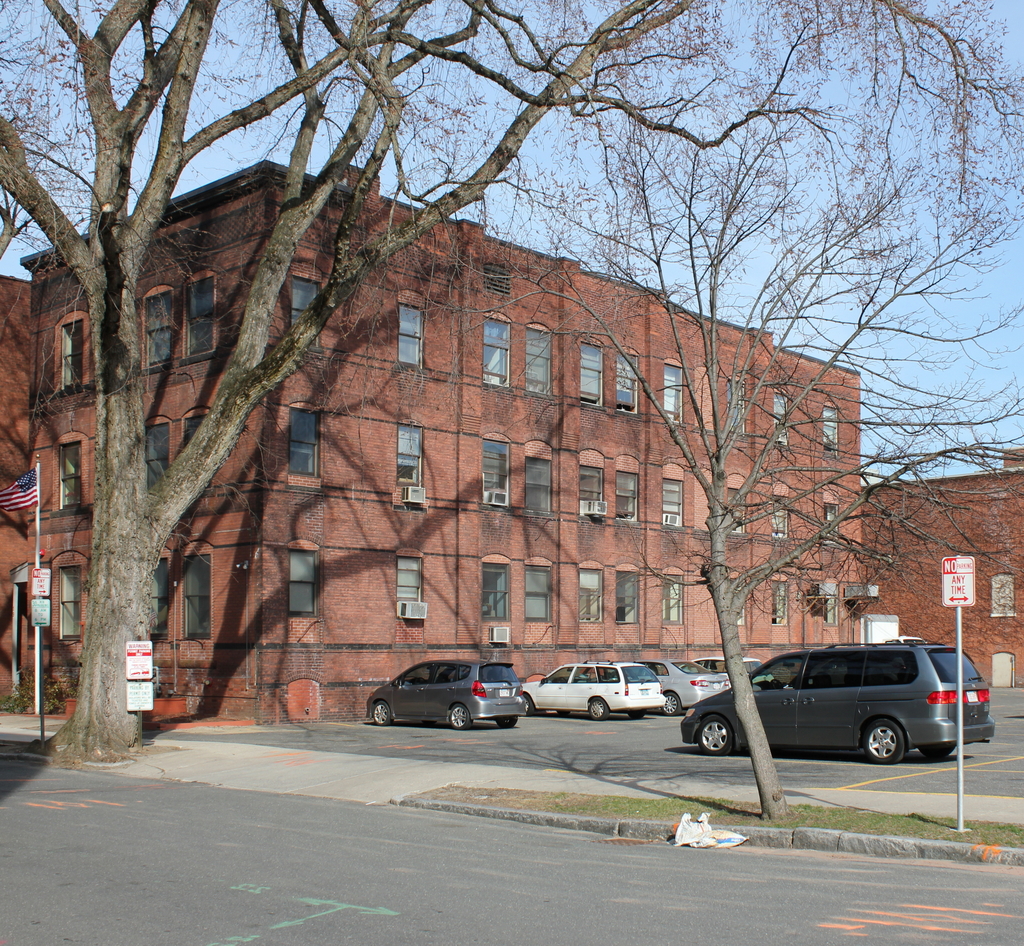
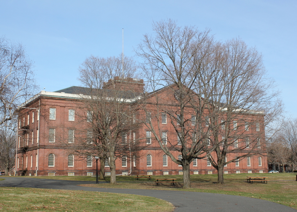
The Arsenal in 2015:

481_2015

Springfield had long been a center of production for US military firearms, beginning in 1777, during the American Revolution.  The need arose for a suitable location to manufacture and store arms and ammunition, and several sites in New England were considered, including Brookfield Mass. and Hartford.  However, in the end General Henry Knox recommended Springfield, and George Washington agreed.  Perhaps Knox had recalled passing through Springfield in early 1776 while bringing cannon from Ticonderoga to Boston, but either way he determined that it was the best location.

The location of Springfield was particularly valuable, as it was along several major roads, leading to Boston, Albany, Hartford, and other points south.  The Connecticut River and several major tributaries were also an advantage, although unlike at Hartford the river was not navigable by ocean-going vessels at this point.  This had been one of the strongest arguments in favor of Hartford, but it was also one of the main weaknesses of the Hartford plan – British ships could easily sail up the river and attack.  Springfield’s location, some 20 miles north of the head of navigation, meant that the town was secure from British naval attacks.  Another important feature in Springfield is the hill that the Armory is located on.  Situated on a broad plateau above the downtown area, the Armory is only three quarters of a mile from the river, but is about 150 feet higher in elevation.  In the unlikely event that Springfield was attacked, this would have been an easy position to defend.

However, while the Armory itself dates back to the 1700s, most of the buildings on the site date to the mid 1800s, including the main arsenal seen in these photos.  This building was built between 1847 and 1851, and it served as a storehouse for the weapons produced at the Armory.  It was built during the Mexican-American War, and it played a vital role in the Civil War just a decade later.  Springfield had been one of two federal arsenals prior to the war, with the other being at Harpers Ferry, Virginia.  Since this facility was lost early in the war, Springfield became the primary manufacturing center for Union firearms.  It continued in this role throughout World War I, World War II, and even into the Vietnam War before its closure in 1968.  Today, the Armory is National Historic Site, and is also home to Springfield Technical Community College.  The arsenal today hasn’t changed much since its completion in 1851, although today it serves as a museum run by the National Park Service.

Trolley Barn, Springfield Mass

The Springfield Street Railway trolley barn at the corner of Main and Carew Streets, around 1905. Photo from Springfield Present and Prospective (1905).

The building in 2023:

The late 19th century saw a dramatic growth in suburbs, and this was fueled in part by the development of inexpensive forms of mass transit such as street railways.  Although most commonly associated with electrified trolleys, these originally started as horse-drawn cars on rails.  This was the case in Springfield, where the Springfield Street Railway opened in 1870.  The original line was a single track that ran about 2.5 miles from Hooker Street in the North End, where the stables were located (not coincidentally, this is now the site of the PVTA headquarters), south along Main Street to State Street, and then along State Street to Oak Street, just past the Armory.  The line was served by four cars and 24 horses, and rides were eight cents each or 16 for a dollar.

It must have been popular, because within four years the network was expanded east on State Street to Winchester Square, and south on Main Street to the Mill River.  More lines were later opened, along Maple and Central Streets to the Watershops, and other lines to Indian Orchard, Brightwood, and along Worthington Street.  Meanwhile, fares continued to drop, first to six cents and then to five.  The biggest change, however, came in 1891, when all of the lines were electrified to run trolleys instead of horse-drawn cars.

By the end of the 19th century, the network was extended to Longmeadow, East Longmeadow, and Feeding Hills, and connections were made to street railway networks in Holyoke, Westfield, Northampton, Palmer, and Hartford.  As a result of the growth of the company, this building was built in 1897 as a new headquarters, at the corner of Main and Carew Streets in Springfield’s North End.  At the time that the first photo was taken, the company operated almost 94 miles of track, with 48 of those miles in Springfield, and operated 227 cars on the lines.

However, as was the case with trolley lines around the country, the Springfield Street Railway wouldn’t last.  Just as electrified trolleys replaced horse-drawn cars, automobiles and buses replaced the trolleys.  The trolley barn (the name itself is a holdover from when the horses were housed in literal barns) is still there, and still looks very much the same as it did over 100 years ago.

Main & Emery Streets, Springfield Mass

Main Street looking south from Emery Street in Springfield around 1892.  Photo from Picturesque Hampden (1892).

479_1892c picturesquehampden

The scene in 2015:

479_2015

Aside from the railroad arch barely visible in the distance, I’m pretty sure there’s nothing in the 1892 scene that still exists today.  Unlike in other neighborhoods of Springfield, the North End retains very few historic buildings; just about the entire area between the railroad and I-291, extending a block on either side of Main Street, is new development from the 1970s.  The 1920 city atlas shows literally hundreds of houses and other buildings in this area, but today there is not one permanent resident within nearly a quarter mile of this spot.  Instead, there are commercial developments and highways.  The Springfield Republican offices are to the right, and across the street is the US Post Office.  Not visible to the left of the post office is a shopping plaza, and beyond the Republican building on the right is the Peter Pan bus terminal.  In the opposite direction, looking north along Main Street there are several professional offices, and then the sprawling I-291 interchange with I-91, both of which consume substantial real estate in the North End.

South Church, Springfield Mass

The old South Church building on Bliss Street in Springfield, probably around 1865-1875. Photo courtesy of the New York Public Library.

478_1865-1885c nypl

The location in 2015:

478_2015

For many years, the First Church in Springfield was the only church in town; it wasn’t until the first half of the 19th century that other churches started to form.  Many of these were offshoots from the first church, some of whom left because of doctrinal differences, such as the Unitarian Church.  However, others left the church on better terms, in order to form new congregations to meet the needs of the growing town (and soon to be city).  The South Church was one of these.  They were formed in 1842, and originally met in the parish house of the First Church before building their own church a few blocks away on Bliss Street.

The first pastor was Noah Porter, who served from 1843 to 1846, when he accepted a position as a professor at his alma mater, Yale College.  He later went on to serve as president of Yale from 1871 to 1886.  Following Porter’s departure, Dr. Samuel G. Buckingham became the pastor, and served for 40 years.  Buckingham was also an author, and he wrote a biography of his brother William Alfred Buckingham, who was Governor of Connecticut from 1858 to 1866 and a US Senator from 1869 to 1875.

During Buckingham’s tenure as pastor, the church outgrew the building on Bliss Street, and in 1875 they moved to a new location on Maple Street.  South Congregational Church is still there, and still meets in the 1875 building.  Meanwhile, on Bliss Street, the old church was demolished by 1884, which was the year that the Women’s Christian Association built a boarding house on the site.  That building is still there as of 2015, serving as the home of the Springfield Rescue Mission, although it is scheduled to be demolished later in the year to make way for the MGM Springfield casino.

Charles Merriam House, Springfield, Mass

The former Charles Merriam house at 61 Howard Street in Springfield, around 1892. Photo from Picturesque Hampden (1892)

474_1892c picturesquehampden

The location in 2015:

474_2015

This house on Howard Street was built around the 1830s, and was the home of Charles Merriam. He and his brother Charles had grown up in West Brookfield, but in 1831 they moved to Springfield and, the following year, opened a publishing company called G. & C. Merriam. A few years later, the Merriams purchased the rights to Noah Webster’s dictonary, which turned out to be a wise business move. Merriam-Webster, as the company is now known, is still headquartered in Springfield, and their famous dictionary is still being published today.

Charles married his first wife, Sophia Warriner, in 1835, and the couple had five children. She died in 1858, and two years later he remarried to Rachel Capen, a 36 -year-old widow. They continued living here in this house, and Rachel became involved in charitable efforts in the city, which included being one of the founders of the Home for Friendless Women. It was established in 1865 with Rachel as its first president, and provided shelter and services for needy women and children.

The original building for the Home for Friendless Women was located on Union Street, essentially in the Merriams’ backyard. Within a few decades it was too small to meet the growing needs, though. Shortly after Charles’s death in 1887, Rachel donated the home to the organization, who was using it by the time the first photo was taken. However, within a few years they built a new building on William Street, and the Howard Street property was sold.

By the 1890s, Howard Street was hardly the upscale residential street that it had once been when Charles Merriam moved in more than 60 years earlier. The 1900 census shows that the street was predominantly French-Canadian, a fact emphasized by the presence of St. Joseph’s Church, a French Catholic church visible in the extreme right of the first photo. The former Merriam house was at this point owned by Napoleon Byron, a French-Canadian undertaker who lived here with his wife Emily, their seven children, and three boarders.

The old house did not remain here for much longer, though. It was demolished by 1905, when the Howard Street School was built to serve the growing population of the South End.  This school later became the Zanetti School, and was used up until 2009.  Two years later it sustained significant damage in the tornado that passed through Springfield, and as of April 2015 it is scheduled to be demolished, pending final approval from the state historical commission.  The current MGM Springfield casino plans call for the construction of a parking garage on the spot of the school.

Put’s Bridge, Springfield Mass

The old covered bridge across the Chicopee River from Springfield to Ludlow, taken from the Springfield side in 1897. Photo courtesy of the Hubbard Memorial Library.

473_1897 hubbardmemlib

The present-day bridge in 2015:

473_2015

Alternately called Putts Bridge, this spot at Wallamanumps Falls on the Chicopee River has long been the site of a bridge connecting Springfield and Ludlow.  The early accounts are somewhat vague, but the first bridge was built in either the late 1780s or early 1790s.  Either way, a bridge was definitely here by 1794; prior to that, Ludlow’s 500 or so residents would have to get to and from Springfield by fording the river, a task that I can’t image was particularly pleasant or safe.  The bridge was constructed by Eli Putnam, hence the name Put’s bridge.  However, bridges here didn’t seem to have much of a lifespan; in the next 30 years, three additional bridges would have to be constructed on this site.

The 1822 bridge must have been different, because it lasted until this 1897 photograph.  By this point, though, the 75 year old bridge was starting to show its age, and the next year it was replaced with a new iron bridge.  However, the replacement didn’t even last half as long as its predecessor before it was replaced by the current bridge in 1930.  Today, this concrete and steel bridge carries Route 21 across the river, and it still serves as the primary connection from Ludlow to Springfield.  The one difference in the location of these two photos is that the covered bridge was at a substantially lower elevation, so the 1897 photo would’ve actually been taken partway down the hill toward the river.  I could’ve recreated the scene from here, but I chose this location since it represents what the surface of bridge today looks like, rather than just the underside of it.