Lost New England Goes West: Alcatraz Island, San Francisco

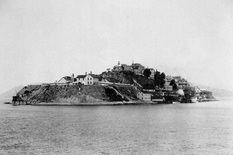
Alcatraz Island in San Francisco Bay, around 1902-1905. Image courtesy of the National Park Service.
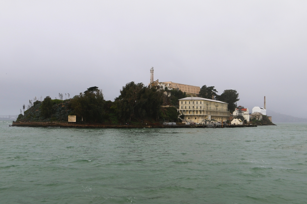
902_1902-1905c nps

Alcatraz in 2015:

Alcatraz Island is located at a strategic point just inside the entrance to San Francisco Bay. The United States acquired California in 1848, and within ten years this small island had been fortified to protect the bay from any potential threats. Known as the Alcatraz Citadel, it was finished just in time for the Civil War, and although it never saw any combat during the war, its isolated location made it an ideal place to house Confederate prisoners.

After the war, the focus on Alcatraz shifted from defense to incarceration, and from 1868 to 1933 it functioned as a military prison. The first photo was taken during this era, showing a number of buildings on the island that were used to house either the inmates or the military personnel stationed there. At the top of the hill in the first photo is the Alcatraz Citadel, which was demolished a few years later to build the main prison building that stands there today. Most of the other buildings from the first photo have since been demolished, including those along the water, which were replaced by Building 64 in 1905. This large building, which was originally used to house military officers and their families, is still standing today just to the right of the center of the photo.

When the military prison closed in 1933, the property was transferred to the Department of Justice, and in 1934 it reopened as a civilian prison for the nation’s most difficult prisoners. Considered essentially escape-proof, there were never any confirmed successful escapes, although three inmates did disappear in the famous 1962 attempt. Alcatraz was expensive to maintain, though, and it closed in 1963. After the closure, the island was occupied by Native Americans for 19 months in 1969-1971, during which time several of the buildings were burned. Later, the island was acquired by the National Park Service, and is now open to the public as part of the Golden Gate National Recreation Area.

This post is part of a series of photos that I took in California this past winter. Click here to see the other posts in the “Lost New England Goes West” series.

Lost New England Goes West: Old Saint Mary’s Cathedral, San Francisco (3)

Another view of the Old Saint Mary’s Cathedral, taken looking down California Street, around 1900. Image courtesy of the Library of Congress, Historic American Buildings Survey Collection.

900_1900c loc

The view in 2015:

900_2015
The first photo shows California Street just a few years before nearly this entire scene was destroyed in the 1906 earthquake. The most prominent building in the first photo is the Old Saint Mary’s Cathedral, and this is also the only building that survives to the present day. As seen in the previous post, though, not much is left of the original building. It was completely gutted in the fires, and today only the exterior walls are left from the 1854 church. The city around the church has obviously changed; in the distance are the skyscrapers of the Financial District, and in the foreground is Grant Avenue, part of the city’s Chinatown neighborhood.

The only other feature that both photos have in common is the cable cars. One of San Francisco’s most recognizable symbols, the cable car line on California Street was established in 1878. Although more expensive to operate than conventional electric trolleys, cable cars remained in use for many years because of the city’s many hills, which are far too steep for a trolley. Rather than relying on overhead wires for power, cable cars are literally pulled up the hills on a continuously-moving 1.25 inch steel cable. To stop the car, the operators simply disengage from the cable and reconnect when they are ready to continue uphill. The technology has not changed much since the first photo, but the major difference is that today’s cable cars are primarily tourist attractions rather than as a significant part of the city’s public transit system.

This post is part of a series of photos that I took in California this past winter. Click here to see the other posts in the “Lost New England Goes West” series.

Lost New England Goes West: Old Saint Mary’s Cathedral, San Francisco (2)

Old Saint Mary’s Cathedral, at the corner of California Street and Grant Avenue, in the aftermath of the April 18, 1906 earthquake and fires. Image courtesy of the Library of Congress, Historic American Buildings Survey Collection.

899_1906c loc

The church in 2015:

899_2015
As mentioned in an earlier post, this church was built in 1854 as the first Catholic cathedral in San Francisco. The archdiocese moved to a new building in 1891, but Saint Mary’s remained a parish church. In 1906, though, the building burned in the earthquake that destroyed much of the city. The first photo shows the church after the fire, with interior was completely gutted. The stained glass windows were gone, and the heat of the fire even melted the bells and the marble altar.

However, the brick walls withstood both the earthquake itself and the fires, and the church reopened in 1909 with a new interior. Over a century later, it remains an active congregation, and it is a prominent landmark in the middle of San Francisco’s Chinatown neighborhood.

This post is part of a series of photos that I took in California this past winter. Click here to see the other posts in the “Lost New England Goes West” series.

Lost New England Goes West: Dupont Street, San Francisco

Looking north on Dupont Street (now Grant Avenue) in San Francisco, sometime in the 1850s. Image courtesy of the Library of Congress, Historic American Buildings Survey Collection.

898_1850-1860c loc

Grant Avenue in 2015:

898_2015
This street has been at the heart of San Francisco’s Chinatown neighborhood since the first photo was taken over 150 years ago. Originally named Dupont Street, it soon became a red light district, notorious for its opium dens, brothels, and gang violence. In the background of the first photo is Old Saint Mary’s Cathedral, which opened in 1854 and, as a warning to would-be patrons of the neighborhood, has an inscription below the clock that reads, “Son, Observe the Time and Fly from Evil.”

The 1906 earthquake destroyed the entire street along with the rest of Chinatown, leaving only the burned-out shell of the church still standing from this scene. The disaster gave the city the opportunity to clean up the seedy establishments in the area, and to reflect this change the street was even renamed, to Grant Avenue. The buildings in the foreground of the 2015 scene were probably built in the immediate aftermath of the earthquake, and the old church is partially visible in the distance. The street is still a popular destination in San Francisco, though not for the same reasons in the 19th century; instead of brothels and opium dens, Grant Avenue of today is lined with Chinese restaurants and shops that sell gifts, souvenirs, and jewelry.

Lost New England Goes West: Old Saint Mary’s Cathedral, San Francisco

Old Saint Mary’s Cathedral at the corner of California Street and Grant Avenue in San Francisco, around 1856. Image courtesy of the DeGolyer Library, Southern Methodist University.

897_1856c smu

The church around 1866. Image courtesy of the Library of Congress, Lawrence & Houseworth Collection.

897_1866c loc

The church in 2015:

897_2015
As mentioned in earlier posts, San Francisco of the 1850s was very different from just a decade earlier. When gold was discovered in California in 1848, its population was just a thousand, but by the early 1850s it had jumped to over 30,000, and was rapidly growing. To accommodate the number of Catholics, the city’s first cathedral was built here in 1854, and the building has stood here ever since. At the time, it was located near the fringes of the city, near Chinatown and some of the notorious red light districts, which explains the “Son, Observe the Time and Fly from Evil” inscription just below the clock.

The first photo was taken before the steeple was completed, but by the early 1860s the church looked essentially the same as it does today. It served as the cathedral for the Archdiocese of San Francisco until 1891, and since then it has been a parish church. In 1906, it was one of the few buildings in the area to survive the earthquake, which did no serious structural damage to it. However, the earthquake started fires that gutted the building, so today the only original part of the church is the brick exterior.

The surrounding Chinatown neighborhood was rebuilt after the fires, and today it is home to the largest Chinese population in the world outside of Asia. This section of Grant Avenue in particular is a major tourist attraction, and Old Saint Mary’s Cathedral remains both an active church and also a major landmark that dates back to the city’s early years as a Gold Rush town.

This post is part of a series of photos that I took in California this past winter. Click here to see the other posts in the “Lost New England Goes West” series.

Lost New England Goes West: Palace Hotel, San Francisco (3)

The Palace Hotel in San Francisco, seen from the corner of Market, Kearny, and Geary Streets in San Francisco, probably on April 15, 1906. Image courtesy of the Library of Congress.

896_1906c loc


The new Palace Hotel, around 1910-1920. Image courtesy of the Library of Congress, Bain Collection.

896_1910-1920c loc

The hotel in 2015:

896_2015
The first photo here shows the original Palace Hotel as it appeared shortly before it was destroyed in the 1906 earthquake. The caption reads “The Palace April 15. Copyright 1906 Pillsbury Picture Co.”, so it appears to have been taken on April 15, 1906, just three days before the disaster. The hotel had been a San Francisco landmark since its completion in 1875, and as explained in an earlier post it had been specifically designed to withstand both earthquakes and fire. However, while its thick walls survived the earthquake itself, the building was gutted by the subsequent fires, as seen in the first photo of this earlier post, which was taken as the building burned. Yet another previous post, taken from almost the same spot as this April 15 scene, shows the burned-out remains of the hotel and other buildings along Market Street.

Three years later, the hotel was rebuilt on the same site, as seen in the second photo, and it retained its status as one of the city’s premier hotels. Several years after the second photo was taken, President Warren G. Harding died in an eighth-floor suite on this side of the building. He was visiting the city during a tour of the west coast, arriving on July 29, 1923. His health had been rapidly deteriorating amid a busy schedule, and he spent several days in the hotel before his sudden death from an apparent heart attack on August 2.

Today, not much has changed in the “new” Palace Hotel’s exterior appearance. It remains a prominent San Francisco hotel, and the buildings on either side of it are also still standing from the second photo. Market Street is as busy as it was in the early 1900s, and trolleys still run down the middle of the street as they did a century ago. Part of the “F” line of the Muni system, it runs historic streetcars, a few of which date back to the era the second photo was taken. The one in this particular 2015 scene is a PCC streetcar that was built in 1948, making it still far closer in age to the first two photos than to the present-day.

This post is part of a series of photos that I took in California this past winter. Click here to see the other posts in the “Lost New England Goes West” series.