Governor’s Carriage, Newport, Rhode Island

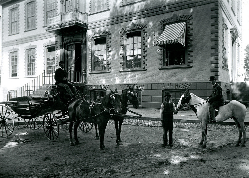
A group of men pose in front of the Old Colony House in Newport, around 1880. Image courtesy of the Providence Public Library.
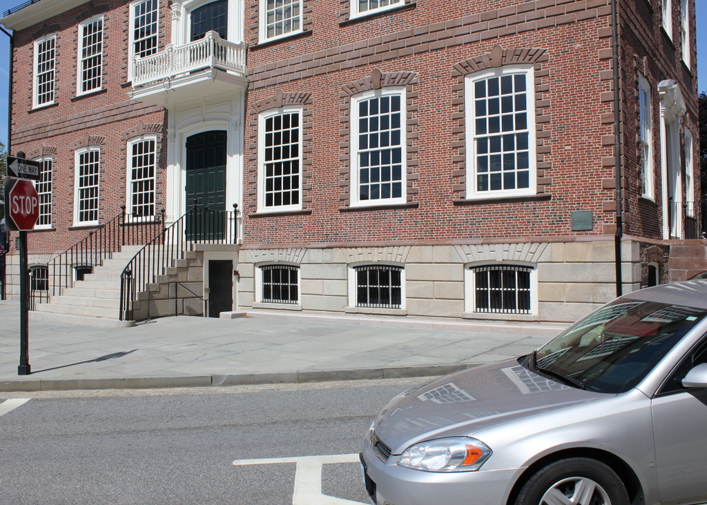
The scene in 2017:

The Providence Public Library’s information on this photo does not provide any context for the first photo, aside from the title of “Governor’s Carriage Newport” and the approximate date of 1880. It does not seem clear, for example, why this carefully-posed photo would include the governor’s carriage yet not the governor himself, but it was taken in front of the Colony House, which at the time functioned as one of Rhode Island’s two state houses, with the other being located in Providence.

As mentioned in an earlier post, the Colony House was built in 1741, and was the work of Newport architect Richard Munday. The exterior was heavily influenced by the work of Christoper Wren, and the interior featured an open hall on the first floor and legislative chambers on the upper floor. For many years, Rhode Island did not have a fixed capital city, with the legislature instead holding sessions on a rotating basis in each of the state’s five county seats. When in Newport, the legislature met here in this building, and continued doing so even after 1854, when the rotation was reduced to just Providence and Newport.

This unusual arrangement continued throughout the 19th century, and the building was still in use by the state government when the first photo was taken around 1880. The practice of alternating legislative sessions finally ended in 1900, though, and Providence became the state’s sole capital city. For the next 26 years, though, the building was used as the courthouse for Newport County, until the current county courthouse was completed in 1926. Located directly to the right of the Colony House, the new courthouse was built with a Colonial Revival style that bears strong resemblance to its predecessor, and the two buildings still stand side-by-side at the eastern end of Washington Square.

Although no longer used as either a state house or as a county courthouse, the building is still owned by the state, and has been a part of several important events over the years. In 1957, President Eisenhower – who spent several summers here in Newport while serving as president – gave a short speech from the front steps here, and 40 years later both the exterior and interior of the building were used for scenes in the 1997 film Amsted, which was set in 1840s New Haven but filmed here in Newport because of the city’s well-preserved historic downtown.

Today, the Colony House is considered a landmark of Georgian-style architecture, and it is one of the best-preserved public buildings of its era in America. The building was already around 140 years old when the first photo was taken, and nearly 140 years have elapsed since then, but there is essentially no difference in its appearance between the two photos. In recognition of this, it was designated as a National Historic Landmark in 1960, and the building is currently operated as a museum by the Newport Historical Society.

Lost New England Goes West: Chinatown, San Francisco (2)

The corner of Grant Avenue and Washington Street in San Francisco, around 1920-1930. Image courtesy of the Library of Congress, Arnold Genthe Collection.

886_1920-1930c loc

The view in 2015:

886_2015
While the Arnold Genthe photo in the previous post showed San Francisco’s Chinatown before the 1906 earthquake, this view a block away shows the neighborhood some 20 years after it was rebuilt. By this time, though, Chinatown was seeing the effects of many years of anti-Chinese immigration policies, such as the Chinese Exclusion Act of 1882, which made it almost impossible for Chinese women or families to immigrate to the United States. When the first photo was taken, the neighborhood’s population was at an all-time low, and this would not begin to rise again until after World War II, when the Exclusion Act was repealed due to American alliances with China during the war.

Today, it is the largest Chinese community in the world outside of Asia, and in the past 90 years or so this particular view has hardly changed. The building is still standing, as are the ones in the distance to the left, and even minor details such as the fire escapes and the lamppost are the same as they were in the 1920s. The influence of Chinese culture is still very apparent, and Grant Avenue in particular, as shown here, is a major tourist destination in San Francisco.

This post is part of a series of photos that I took in California this past winter. Click here to see the other posts in the “Lost New England Goes West” series.

Lost New England Goes West: Chinatown, San Francisco (1)

The corner of Jackson Street and Grant Avenue in San Francisco, around 1896-1906. Image courtesy of the Library of Congress, Arnold Genthe Collection.

885_1896-1906c loc

The scene in 2015:

885_2015
San Francisco’s Chinatown is the largest Chinese community in the world outside of Asia, and it was also America’s original Chinatown. Immigrants from China arrived here around the same time that almost everyone else did, during the Gold Rush of the late 1840s and early 1850s. Later on, many other Chinese people came to find work on projects such as the Transcontinental Railroad, and this neighborhood became an ethnic enclave within the city.

Photographer Arnold Genthe was primarily known for his portrait work, and his clients included many notable politicians, writers, and entertainers. In addition, he photographed the immediate aftermath of the 1906 earthquake, including the one in the previous post, but his works also included hundreds of photos of Chinatown that were taken beginning in the 1890s. His collection, which includes the first photo here, provides the only real glimpse into everyday life in Chinatown before the earthquake.

This scene, along with the rest of Chinatown, was completely destroyed in the earthquake, and some politicians sought to use the disaster to rebuild Chinatown further from the center of the city. However, the plans ultimately failed, and Chinatown was rebuilt here, where it continues to be a vibrant community as well as a popular tourist destination in the city.

This post is part of a series of photos that I took in California this past winter. Click here to see the other posts in the “Lost New England Goes West” series.

Collins Inn Livery Stable, Wilbraham, Mass

The livery stable at the Collins Inn on Boston Road in North Wilbraham, around 1895. Image courtesy of the Wilbraham Public Library.

744_1895c wpl

The scene in 2015:

744_2015
This is the same building seen in the previous post, just from a different angle and several years later.  Although the photo is undated, there is at least one clue that gives a good indication of when it was taken.  Just below the large “Livery” sign, there are posters for Buffalo Bill’s Wild West, which was performing in Springfield on “Thursday, May 23.”  There appears to have been a performance in Springfield on that day in 1895, and it was a Thursday, so the photo was probably taken around that time.

In the days before automobiles, livery stables such as these would have provided stabling and feed for horses, and the carriages out front show a variety of horse-drawn carriages that would have been used at the time.  One of the carriages has two young children sitting in it, so perhaps the man posing with the horse is about to hitch it to that carriage.  He is presumably an employee of the stables, which was operated as part of the Collins Inn next to it.

At the time that the first photo was taken, cars were just starting to be developed, but within about 20 years they would essentially replace horses, putting livery stables like these out of business.  Perhaps not coincidentally, the Collins Inn closed in 1915.  I don’t know when the stables were demolished, but it seems fitting that the modern equivalent, a gas and repair station, now stands on the site.

Collins Inn, Wilbraham, Mass

Collins Inn at the corner of Boston Road and Chapel Street in North Wilbraham, probably in the 1890s or early 1900s.  Image courtesy of the Wilbraham Public Library.

742_1800sc wpl

The scene in 2015:

742_2015
The historic center of the town of Wilbraham has always been along Main Street in the town’s approximate geographic center.  When it was first settled in the 1700s, this was the ideal place for farming, but as changes in industrialization, transportation, and communication came about in the 1800s, the village of North Wilbraham gained prominence.  Its location on the banks of the Chicopee River and along the main road from Springfield to Boston made this area an important spot for industry and transportation.  In 1839, the Boston & Albany Railroad opened through here, with the North Wilbraham railroad station being located right across the street from here.

The building in the foreground of the first photo was the Collins Inn, which was opened in 1874 by Warren L. Collins.  It sat directly across Boston Road from the railroad station, and across Chapel Street from the Hollister Block, which at the time was used as a drugstore and post office.  In addition to the inn, Collins also operated a livery stable on the site, and ran a stagecoach line from here to the center of Wilbraham, about two miles away.

Aside from transportation, though, the Collins inn also offered Wilbraham another connection to the outside world – the telephone.  The telephone was invented in 1876, and within just four years a line was established from here to the center Wilbraham, at a cost of $30 per year for subscribers.  However, a few years later the cost increased to $100 per year (equivalent to over $2,400 today), and the service was discontinued because of a lack of families willing to pay.  When phone service was re-established in 1904, the Collins Inn became the town’s telephone exchange office for the New England Telephone and Telegraph Company, serving 21 customers in Wilbraham.

The telephone exchange remained here until 1914, when it moved to a different building across the street.  Around the same time, the Collins Inn closed, although the building itself remained standing for some time.  The 1964 History of Wilbraham book indicates that it was still standing at the time, although today its former location is now a parking lot.

Saint Thomas Cemetery, Southington, Connecticut (3)

Another photo of the All Souls’ Day Mass in Southington’s Saint Thomas Cemetery, in May 1942. Image courtesy of the Library of Congress, FSA-OWI Collection.

657_1942-05 loc

The cemetery in 2015:

657_2015
As seen in the previous two posts, photographer Charles Fenno Jacobs took a number of photos of the All Souls’ Day Mass.  This event probably had a special significance for those attending; it was right around Memorial Day, and some perhaps had already lost a loved one in the war.  Many of the others certainly would have had a son, grandson, brother, or husband serving in the military, and although they wouldn’t have known how long the war would last, it would end up being over three years before it ended.

Today, this section of the cemetery has hardly changed.  The two large crosses that Jacobs used to frame his 1942 shot look the same, and the only obvious difference – aside from the lack of people – is the addition of a few more headstones in the foreground.