Highland Street, Plymouth, NH

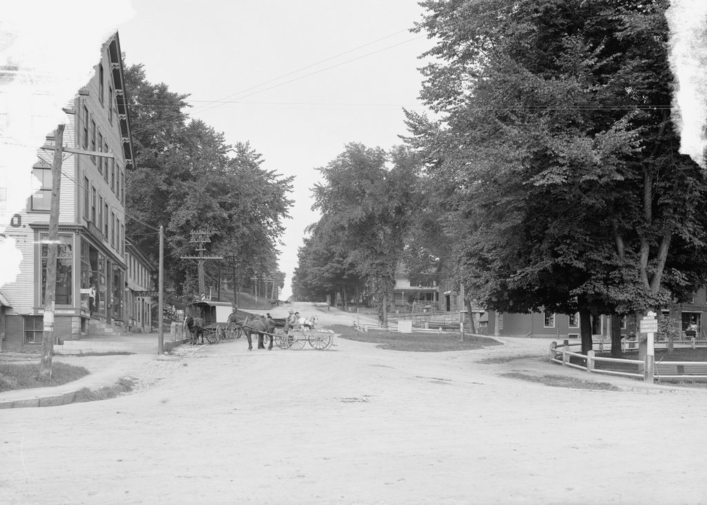
Looking up Highland Street from Main Street in Plymouth, around 1900-1910. Image courtesy of the Library of Congress, Detroit Publishing Company Collection.

598_1900-1910 loc

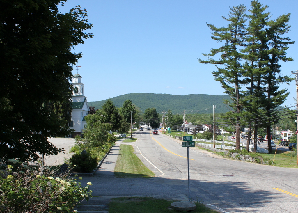
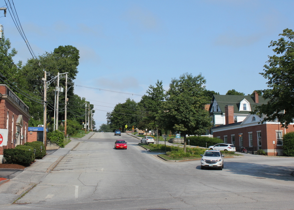
Highland Street in 2018:

It’s hard to tell, but I don’t know if any of the buildings from the first scene survive today.  Many of the buildings in both photos are partially hidden by trees, but the most prominent building in the 1900s photo is the Tufts Building, on the far left.  It was built in 1880 by John S. Tufts, a local businessman who opened a dry goods store in 1861 just around the corner from here, and later opened a drugstore.  He died in 1888, but over a decade later his name still appears on the sign above the door.  There are at least four horse-drawn carriages outside the building in the first photo, and one of them is filled with milk cans, so these were probably local farmers making deliveries to the stores in the building.

I don’t know what happened to the Tufts Building, but it is possible that, like many other 19th century wood-framed commercial buildings, it may have burned down.  The building on the site today is Northway Bank, formerly the Pemigewasset National Bank.  This building opened in 1955, with President Eisenhower cutting the ribbon at the opening ceremonies.  The only building that might be the same from the first photo is the white building to the right.  There is a similar-looking building in the first photo, which appears to have been used as a workshop.  There are several carriages in front of it, so perhaps this was a carriage repair shop.  If it is the same building, today it is used as off-campus housing for students at Plymouth State University.

Old Grafton County Courthouse, Plymouth, NH

The Old Grafton County Courthouse on Court Street in Plymouth, around 1900-1910 during its use as a library. Image courtesy of the Library of Congress, Detroit Publishing Company Collection.

597_1900-1910 loc

The building in 2018:

Over the years, this building has served a variety of purposes in several different locations.  It was built in 1774 as one of two courthouses in Grafton County, and was located at the corner of Russell and Pleasant Streets, less than a quarter mile from where it is today.  During its time as a courthouse, 24 year old New Hampshire native Daniel Webster argued one of his first court cases here in 1806.  He lost, and his client was hanged, but he would nonetheless go on to be a successful lawyer and one of the country’s most powerful politicians of the pre-Civil War era.

While Webster’s career was just beginning, the old courthouse was becoming obsolete, and in 1823 it was replaced by a more substantial brick building.  The old building was moved south of the main village and used as a wheelwright shop, as seen in the photo below, which was taken in 1860 and published in History of Plymouth, New Hampshire (1906):

597_1860 ahistofplymouthnh same building different location
By the 1870s, the century-old building had been abandoned and was in disrepair, but its connection to Daniel Webster’s early career brought it to the attention of Henry W. Blair, a Congressman and future Senator who purchased it in 1876.  After moving it to its present location and renovating it, Blair gave the building to the Young Ladies’ Library Association to use as a public library.  The small building was home to Plymouth’s library until 1991, when the present-day Pease Public Library was built.  Since then, the historic building has been home to the Plymouth Historical Museum.

Plymouth Normal School, Plymouth, NH

Rounds Hall at the Plymouth Normal School, around 1907. Image courtesy of the Library of Congress, Detroit Publishing Company Collection.

596_1907c loc

The building in 2018, now part of Plymouth State University:

The history of Plymouth State University goes back to 1808, when the Holmes Plymouth Academy was established as a training school for teachers.  In 1871, the state took over the school and renamed it the Plymouth Normal School, with “normal” in this sense referring to training teachers.  Like many other normal schools in the country, it went through a series of name changes as the school expanded and added more academic programs.  From 1939 to 1963, it was the Plymouth Teachers College, and from 1963 to 2003 it was Plymouth State College before again being renamed as Plymouth State University.

The building in both photos is Rounds Hall, which was built in 1890 along with a dormitory, which can be seen beyond and just to the left of Rounds Hall in the 1907 photo.  Rounds Hall still stands today, and is the oldest building on campus.  However, Normal Hall, the old dormitory, didn’t last too long.  Not long after the first photo was taken, the barely 20 year old building was in such poor condition that it had to be demolished.  Its replacement, Mary Lyon Hall, was built on the same spot in 1916,  is still used as a dormitory today; it can be seen in the distance beyond the trees.

Sutton House, Center Harbor, NH

The home of Eliza Sutton in Center Harbor, around 1865-1885.  Image courtesy of the New York Public Library.

594_1863-1885c nypl charles bierstadt

The house in 2015:

594_2015
This house on the present-day Whittier Highway was built in 1865 for Eben Sutton, a wool merchant in Peabody Mass., and his wife Eliza.  Eben died before the house was finished, but Eliza lived here for 24 years.  She ran a dairy farm here, using the fields across the street as pastureland.  The photo in this post, taken about 17 years after her death, shows the view from in front of her house looking across the street.  In addition to her agricultural pursuits, she was also a philanthropist, and in 1869 she donated funds to build the Eben Dale Sutton Reference Library at the Peabody Institute Library in her hometown.

The first photo was taken during the time when Eliza Sutton lived there, and the photographer was Charles Bierstadt, a 19th century photographer who specialized in stereoscopic views.  He is probably best known, though, as the older brother of landscape artist Albert Bierstadt. Most of the younger Bierstadt’s paintings were of the American west, but he did several of the White Mountains, not too far from where his brother Charles took this photograph.

The house was damaged by a fire in 1993, but it has since been restored to its original 19th century appearance and operates as the Sutton House bed and breakfast.

Lakefront at Center Harbor, NH

Looking east toward Lake Winnipesaukee from Main Street in Center Harbor, around 1906. Image courtesy of the Library of Congress, Detroit Publishing Company Collection.

593_1906c loc

The same view in 2015:

593_2015
These photos were taken from the same spot as the ones in the previous post, just a little to the right.  The original photos were probably intended to form a panoramic view, because the right side of the other photo and the left side of this one fit together seamlessly.  Center Harbor has long been a popular vacation spot, and the 1906 photo shows cottages and boathouses along the lake.  However, it is also interesting to see corn growing on prime lakefront real estate. Today, this property has been developed, and the Whittier Highway now passes through part of the former cornfield.  The stone wall, which can be seen here and also in this post, once ran along the road for a considerable distance to the south.  Today, much of it is gone, including the section here, which was removed to build the short cross street that connects the Whittier Highway with Main Street.  Further south there are some surviving remnants of the stone wall, although the farmland that it once enclosed has long since disappeared.

Main Street, Center Harbor, NH

Looking northeast on Main Street in Center Harbor, with Red Hill in the distance, around 1906. Image courtesy of the Library of Congress, Detroit Publishing Company Collection.

592_1906c loc

Main Street in 2015:

592_2015
This scene was taken just up the road from the photos in this post; note the Center Harbor Congregational Church, which can be seen in the distance there and on the left here.  The church was built in 1838 and has stood there ever since, overlooking Lake Winnipesaukee.  The cemetery across the street is also still there, and if it wasn’t for the trees in the first photo, the Colonial Hotel would be visible beyond the cemetery on the right.  In the background of both photos is Red Hill, which rises 1500 feet above Lake Winnipesaukee and offers dramatic views of the surrounding landscape.

Over the years, the roads here have changed a bit.  In the 1906 photo, Main Street was the primary route from Meredith to Center Harbor, Moultonborough, and points north.  Today, most of this traffic travels on Route 25, which can be seen on the far right of the 2015 photo.  It is named the Whittier Highway, after poet John Greenleaf Whittier, who used to vacation in Center Harbor in the late 1800s.  Built parallel to Main Street, it cuts across the area where the Colonial Hotel once stood and allows through traffic to bypass much of the center of the village.