Boylston Station, Boston

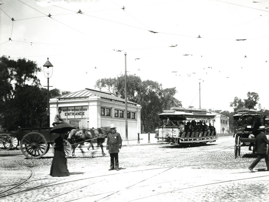
The Boylston subway station, at the corner of Tremont and Boylston Streets in Boston, on August 12, 1897. Image courtesy of the City of Boston Archives.

687_1897-08-12 coba

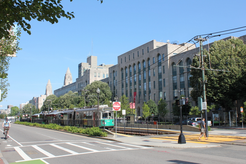
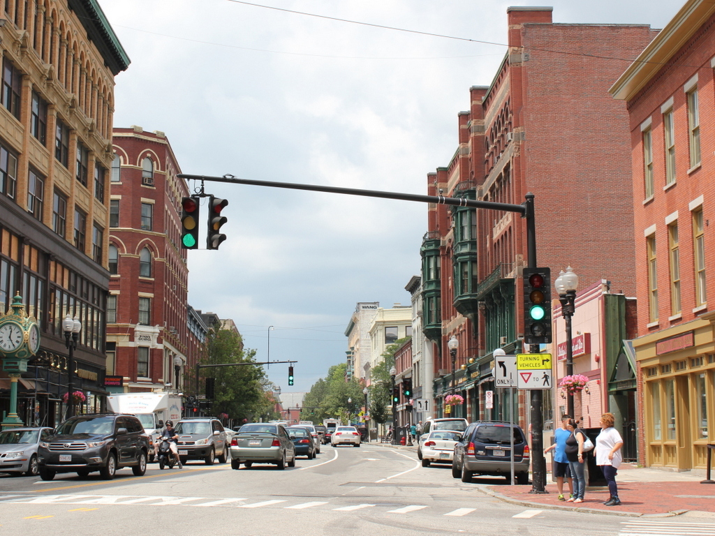
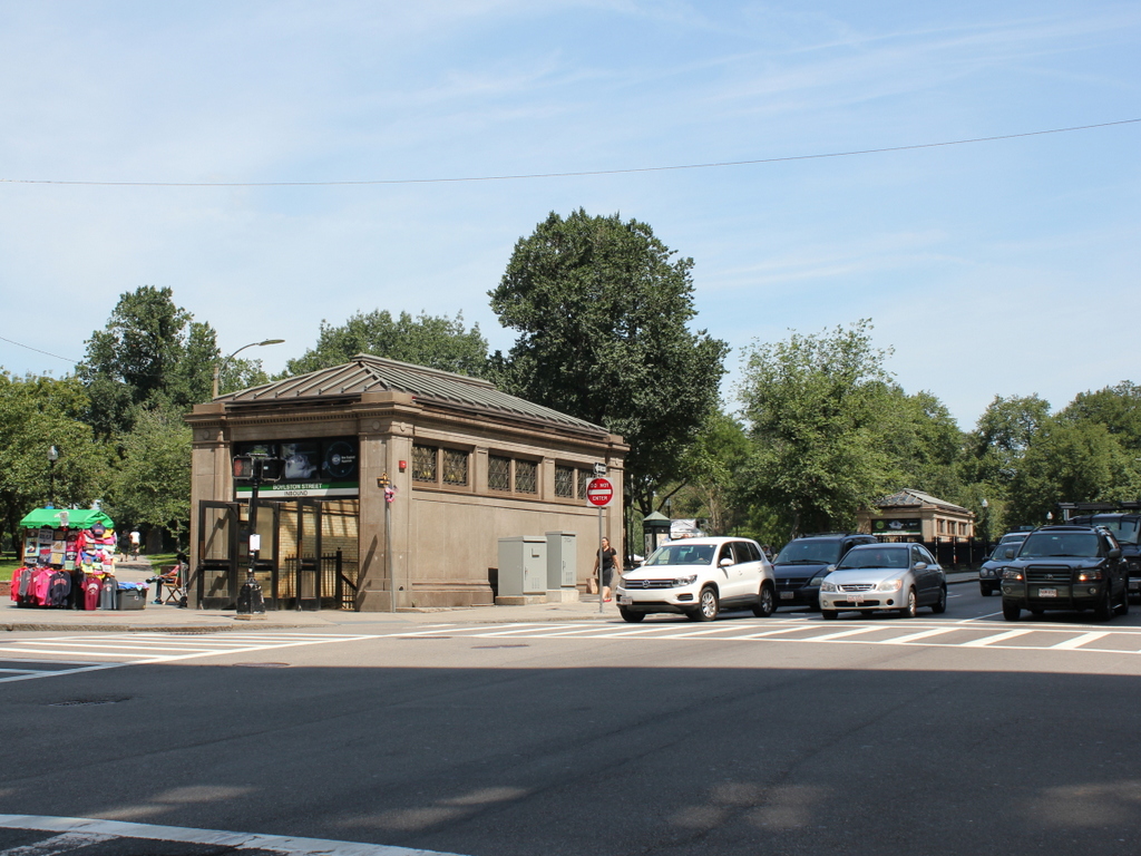
The station in 2015:

687_2015
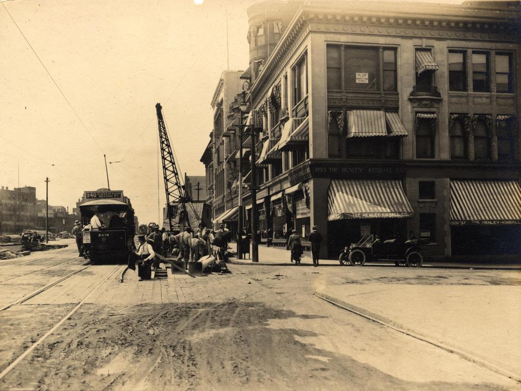
The first photo captures the ending of one era and the beginning of another.  Just a few weeks after the photo was taken, the trolleys that are seen here on congested Tremont Street would be moved underground, giving Boston the distinction of having the country’s first subway tunnel.  The first two stations were Park Street, just over a quarter mile to the north, and this one here at Boylston Street, in the southeast corner of Boston Common.  The project was a major civil engineering milestone, but it didn’t come without tragedy.  At this location earlier in the year, a leaking gas line in the work area under the intersection caused an explosion that killed six people.  The explosion is explained further in this post, which features photos that were taken diagonally across the street from here.

Today, the view really hasn’t changed too much.  The trolleys on the Green Line are still running under this intersection, the distinctive station entrances are still here, as is Boston Common in the background.  Even in the 19th century, this intersection of Boylston and Tremont streets was busy, necessitating the police officer in the left center of the 1897 photo.  The slow shutter speed of the camera has blurred most of the traffic around him, but he is standing perfectly still, posing for the photographer as trolleys, carriages, and pedestrians pass by.  It is still a major intersection today, albeit without the nostalgia of a 19th century officer directing traffic on a cobblestone street.

Boylston Street from Gloucester Street, Boston

Looking west on Boylston Street from the corner of Gloucester Street, on August 6, 1912.  Image courtesy of the City of Boston Archives.

667_1912-08-06 coba

Boylston Street in 2015:

667_2015
The first photo here appears to be documenting the early stages of the work on the Boylston Street Subway, today’s Green Line of the MBTA.  Prior to 1912, the present-day Green Line was only underground from North Station to Arlington, emerging onto Boylston Street at the Boston Public Garden, as seen in this post.  From there, it ran through the Back Bay in the center of Boylston Street, as seen here.  Because of increasing congestion, though, the trolley line was moved underground in 1914.  The new tunnel ran from Arlington Street to Kenmore Square, where it came to the surface in the median of Commonwealth Avenue just east of the square.  I’m not entirely sure what the workers are doing here, but they appear to be doing some sort of excavation on the tunnel – notice the planks in the otherwise dirt road, which probably cover the work that was being done.  In the meantime, the trolleys needed to continue running, so the 1912 scene shows a Reservoir-bound car (today’s “C” Line) passing through the construction area.

Today, Green Line trains still run under this spot in the tunnel that the 1912 workers were building, and on the surface not much has changed on the right-hand side.  Along the mile-long stretch of Boylston Street in the Back Bay, the north side of the street is primarily late 19th and early 20th century low-rise construction, while the south side is almost entirely new.  This contrast can be seen here, as nearly all of the buildings from 1912 are still standing on the right, including the three-story commercial building in the foreground.  It was built in 1905, and in the first photo the corner storefront is occupied by The Henley-Kimball Company, a car dealership that sold Hudson cars.  It was one of many car dealerships along Boylston Street; an awning further down the street advertises for Chalmers, and there are also window signs for Stutz Motor Company and Michelin Tires.

The left (south) side of Boylston Street, however, is significantly different.  In 1912, there were no buildings here; instead, this area was the site of a large rail yard for the Boston & Albany Railroad.  The yard took up the south side of Boylston for three blocks, from Exeter Street to Hereford Street, but over time the land became too valuable to simply use for a rail yard.  The Massachusetts Turnpike now runs through the site of the former yard, and a number of buildings have been built on top of it, including the Hines Convention Center, which can be seen on the far left of the 2015 photo.

Boston University East, Boston

The Boston University East MBTA station on Commonwealth Avenue, around 1939. Image courtesy of the City of Boston Archives.

663_1930sc coba

The scene in 2015:

663_2015
The first photo shows passengers boarding a Boston Elevated Railway trolley at the Boston University East station, in front of the Charles Hayden Memorial Building at Boston University.  It appears to be a Type 4 trolley, which was found on Boston’s many streetcar lines from 1911 until 1950.  Most of those lines have long since been converted into buses, but the line along Commonwealth Avenue is still in use, as the MBTA “B” branch of the Green Line.

The Charles Hayden Memorial Building in the background of both photos was completed in 1939, and it provides an earliest possible date for the photo, which the City of Boston Archives estimated as being in the 1930s.  The building was the first to be built on BU’s Charles River Campus, and just over two years after it opened the United States entered World War II, postponing other construction projects on the campus.  The other buildings along this section of Commonwealth Avenue would not be completed until 1948, but today this area between the Massachusetts Turnpike to the south and the Charles River to the north has become the school’s main campus.

West on Merrimack Street, Lowell, Mass

The view looking west on Merrimack Street from Kearney Square, around 1908. Image courtesy of the Library of Congress, Detroit Publishing Company Collection.

611_1908c loc

Merrimack Street in 2015:

611_2015
These views show the same section of Merrimack Street as the ones in this post, just from the opposite direction.  This area has long been the commercial center of the city, and it saw significant development in the late 19th and early 20th centuries.  Since then, however, there haven’t been many major changes, so this stretch of Merrimack Street is lined on both sides with a number of historic buildings, including three prominent ones that appear in both of these photos: the Colonial Building (1906) on the far left, the Wyman’s Exchange (c.1880) just beyond it, and the massive Hildreth Building (1882) on the opposite side of the street.

The Colonial Building is one of the newest buildings in this scene, and in the 1908 photo it looks like the finishing touches aren’t complete yet, because the storefront windows are still covered in paper.  It was built on the site of Barristers’ Hall, a church-turned-lawyer’s office that had been built in 1843 and burned down in 1905.  The owner, Joseph L. Chalifoux, was a clothing merchant who rebuilt the site and leased the new building to Nelson’s, a five and ten cent store that was probably in the process of opening when the first photo was taken.  Since then, the building was expanded in 1929, and has continued to house retail space and commercial offices, enjoying a prominent location on the corner of Merrimack and Central Streets.

On the other side of Central Street is Wyman’s Exchange, which replaced an earlier building of the same name that was built in the 1830s.  Over the years, a number of businesses have used the storefronts along the Central and Merrimack Street sides, with the upper floor being used for professional offices such as lawyers, doctors, and dentists.  The one major change that has occurred since the first photo was taken was the addition of a fifth and sixth floor atop the original building.  The upper floors match the rest of the building, and it was probably done soon aftert he first photo was taken.  Today, aside from being taller by 50 percent, the building retains much of its historic appearance.

The Hildreth Building was built in several stages between 1882 and 1884, beginning with the part closest to the camera.  One of the building’s first tenants was S & H Knox and Company, a five-and-dime store that was still operating out of the building on the left-hand side when the 1908 photo was taken.  Within a few years, the owner of the company would merge with his cousins’ stores to form F.W. Woolworth.  The storefront on the other side was the home of King’s, a clothing company that asks prospective customers “Why not give us a try?” in a sign over one of the windows. In 1908, the east side of the building featured a large advertisement for Uneeda Biscuit, made by the National Biscuit Company.  The biscuits are no longer made today, but the company has since shortened their name to Nabisco, and they still use a variation of the logo seen on the sign.

Main Street, Laconia, NH

Looking north on Main Street in Laconia at the intersection of Pleasant Street, probably in 1907. Image courtesy of the Library of Congress, Detroit Publishing Company Collection.

608_1908c loc

Main Street in 2015:

608_2015
As far as I can tell, only one building from the first scene survives today: the brick building on the left side of Main Street, just to the right of the center in both photos.  As was the case in many other parts of the country during the 1960s, a number of Laconia’s historic downtown buildings were destroyed as part of an urban renewal project.  However, the most prominent building in the first scene, the Eagle Hotel, was gone before then.  It enjoyed a prominent location right at the intersection of Main and Pleasant Streets, and was just a block away from the railroad station.  Around the time that the first photo was taken, it was one of Laconia’s most popular hotels (and, at $2.50 a day, one of its most expensive as well).  By the 1950s, the former hotel had been demolished and replaced by Woolworth’s, as seen in some of the pre-urban renewal photos featured on this Weirs Beach website.  Today, the site is occupied by a one story brick building with commercial storefronts.  This might be the same building that Woolworth’s was once in, but if so it has been heavily modified over the years.

Part of the urban renewal projects involved changing some of the traffic patterns in downtown Laconia.  Today, Main Street south of here (behind the photographer) is a narrow, single lane one way street that carries northbound traffic.  The buildings on the left-hand side of the street in that section extend about 40 feet closer to the center of the road than the pre-renewal buildings did.  In this scene, the road is as wide as it was a century ago, but it still has just one way northbound traffic, with angled on-street parking taking up what was once the southbound travel lane.  Pleasant Street is now one way, southbound, and any traffic on the street must circle around the former Woolworth’s site and head back north on Main Street.

Although the first scene is mostly deserted, there are a few interesting things going on.  The man on the far left appears to be a street sweeper; he is pushing what looks like a large, wheeled canvas bag while holding a broom and probably a pick.  He is looking at the ground, and it seems like he is about to walk into the path of the oncoming trolley.  The trolley has a handbill on the front, advertising for “Adrift in New York,” which would be showing at the Moulton Opera House on Tuesday, September 17.  The Library of Congress estimates that the this photo was taken in 1908, but September 17 fell on a Tuesday in 1907, so the photo was probably taken in early to mid September of that year.  Plays weren’t the only form of entertainment that was available at the Moulton Opera House, though; a sign on the sidewalk reads “Don’t Fail to See the Great Moving Pictures Tonight.”  The “moving pictures” would have been early silent films, most of which were not preserved and have long since been lost to history.  Likewise, the trolleys have been lost to history; the Laconia Street Railway shut down in 1925 amid growing competition from cars and buses.

Springfield and Eastern Street Railway, Palmer Mass

A Springfield and Eastern Street Railway trolley in downtown Palmer, on Main Street opposite Bridge Street, in 1905. Image courtesy of the Palmer Public Library.

561_1905 palmerhistcom

The scene in 2015:

561_2015
The town of Palmer was once a major transportation hub, as indicated by its nickname, the “Town of Seven Railroads.” Although not all of these railroads were ever operational, at the time that the first photo was taken there were five different railroads operating in the town, but that didn’t include the many trolley lines that also served Palmer. The trolley line along Main Street belonged to the Springfield and Eastern Street Railway, and it connected Monson, Brimfield, and other points east to the city of Springfield, some 15 miles to the west. The line opened in 1898 as the Palmer and Monson Street Railway, and connected the two rapidly developing industrial towns. In 1901, the line was extended to connect with the Springfield Street Railway, and in 1905 the company was renamed to reflect its role in connecting Springfield to the towns to the east.

The first few decades of the 20th century were the heyday for trolleys, but as time went on they faced competition from buses and automobiles.  The line closed by the late 1920s, and today nothing from the first photo has survived., including the building directly behind the trolley in the 1905 scene.  It was the Converse Hotel, which at the time was conventiently located on the main road from Boston to Springfield.  Today, its former location at the corner of Main and Walnut Streets is now a parking lot.