Harpers Ferry, West Virginia

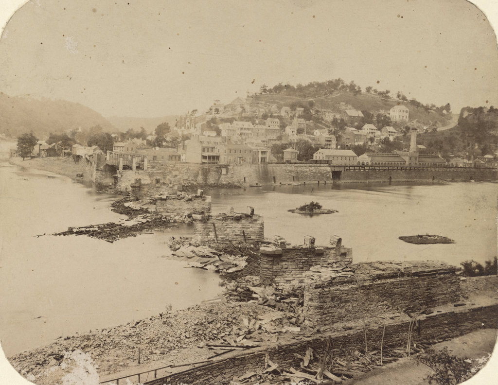
Looking across the Potomac River towards Harpers Ferry from the Maryland side of the river, around June 14, 1861. Image courtesy of the Library of Congress, Civil War Collection.

728_1861 loc

The same view in 2015:

728_2015 loc
The town of Harpers Ferry had only about 1,300 residents at the start of the Civil War, and its land area was just a half a square mile, but it became among the most contested places of the war.  It was literally located on the border of the Union and the Confederacy, changing hands eight times during the war and ending up in a different state by the time it was over.

As its name implies, this area was first settled as a ferry crossing.  Originally part of Virginia, it is located at the confluence of the Potomac and Shenandoah Rivers, and beginning in 1733 colonist Peter Stevens operated a ferry across the Potomac here, enabling settlers from Maryland and Pennsylvania to access the Shenandoah Valley of Virginia.  The town isn’t named Stevens Ferry, though, because around 1748 he sold his land and ferry to Robert Harper, who operated it until his death in 1782.

Because of its transportation connections and relatively defensible position, Harpers Ferry was one of two locations, along with Springfield, Massachusetts, selected by George Washington for federal armories.  Further transportation developments came in the 1830s: the Chesapeake & Ohio Canal (seen in the lower foreground of both photos) was completed as far as Harpers Ferry in 1833, several stagecoach lines were opened in 1834, and the Baltimore & Ohio Railroad reached the Maryland (foreground) side of the river later in 1834.  The first railroad bridge was completed in 1837, allowing a direct connection from the armory to the rapidly growing national rail network.

By 1850, this small town had grown to over 1,700 people thanks to the armory (visible along the waterfront to the right in the first photo), but before the end of the decade it would become the center of one of the major precursors to the Civil War.  In October 1859, abolitionist John Brown led a raiding party of 22 men in an attempt to capture the arsenal and start a slave rebellion.  The raid ultimately failed, and most of the raiders were either killed or were captured and executed, including John Brown, whose December 2 execution was seen as a martyrdom by many northern abolitionists.

The Civil War began just a year and a half after the raid, and Virginia’s state legislators voted to secede on April 17, 1861.  One of the state’s first objectives was to take the Harpers Ferry arsenal, which at the time was guarded by just 65 men.  Led by Lieutenant Roger Jones, they destroyed the arsenal and its 15,000 guns before evacuating the town ahead of the Confederates.  The Confederates didn’t occupy the town for long, though.  They left on June 14, and burned the Baltimore & Ohio bridge as they left.  The remains of the bridge can be seen in the foreground of the first photo, which according to the caption was “photographed immediately after its evacuation by the rebels.”

When the first photo was taken, the town was still relatively intact, but as the war progressed it became somewhat of a no man’s land.  Despite the loss of the armory, it was still a vital transportation corridor for armies on both sides, so between 1861 and 1863 it changed hands several more times.  West Virginia became a state on June 20, 1863, with Harpers Ferry citizens voting 196 to 1 to leave Virginia and join the union.  The town was briefly occupied by the Confederates in early July, but they soon evacuated for the last time and Union solders returned on July 13, finally bringing stability to Harpers Ferry for the rest of the war.

In terms of population, Harpers Ferry never fully recovered from the Civil War.  The armory never reopened, and the population has steadily fallen to less than 300 as of the 2015 census.  However, it has become a major tourist destination, with the Harpers Ferry National Historic Park now comprising much of the historic town.  Although the Chesapeake & Ohio Canal has not operated in nearly a century, there are still several railroad lines that pass through here.

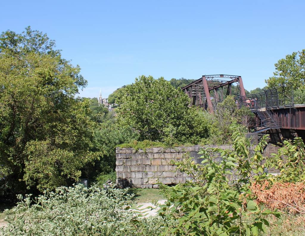
One of the bridges, seen to the right in the 2015 photo, also carries the Appalachian Trail over the Potomac River on a pedestrian walkway on the left side of the bridge.  The bridge pier in the foreground is from an earlier railroad bridge that had been built on the spot of the one that was destroyed in 1861.  This bridge, in turn, was washed away in a 1936 flood, and it was never rebuilt.  Today, the modern railroad bridge, as well as trees along the river, help to hide the view of Harpers Ferry, with only a few buildings visible in the 2015 scene.

(Much of the information for this post came from “To Preserve the Evidences of a Noble Past”: An Administrative History of Harpers Ferry National Historical Park (2004).  For further reading, it and other resources are available online here at the National Park Service website.)

Old City Hall, Boston

Johnson Hall, which served as a courthouse and later as City Hall, on School Street around 1855-1862. Image courtesy of the Boston Public Library.

691_1855-1862c bpl

Boston’s old City Hall, which replaced Johnson Hall, as seen in 1865. Image courtesy of the Boston Public Library.

691_1865 bpl

Old City Hall in 2015:

691_2015
This site on School Street has had two different City Hall buildings, as seen in the photos above, but the history here goes back even further.  From 1704 to 1748, Boston Latin School was located here, and during this time many of the Founding Fathers attended the school, including Benjamin Franklin, John Hancock, Samuel Adams, and Robert Treat Paine.  Years later, Charles Bulfinch designed a courthouse that was built here in 1810; this building, which is shown in the first photo, was used as both a county and federal courthouse in the early 19th century.  From 1841 until 1862, it was Boston’s City Hall, before being demolished and replaced with a newer, larger building.

The new City Hall was completed in 1865, and was one of the first examples of Second Empire architecture in the United States.  This French-inspired style would become very popular in the late 1860s and 1870s, especially in government buildings.  Boston’s old post office, which was built a decade later and just a few blocks away, shares many similar features.  On a much larger scale, the Old Executive Building next to the White House in Washington, DC also reflects the influence of Second Empire designs.

During its time as City Hall, this building saw the rapid growth in the city during the late 1800s and early 1900s.  When it was completed, the city had fewer than 200,000 people, but by the 1950s there were over 800,000, and the city government had long since outgrown this building.  The City Hall Annex, located behind this building on Court Street, was built in 1912 to accommodate more offices, but by the 1960s the city was looking to build a new City Hall.  The current building was completed in 1968, and since then the old building has been extensively renovated on the inside for commercial uses, but the exterior is essentially unchanged from 150 years ago.

Pemigewasset House, Plymouth, NH (1)

The Pemigewasset House in Plymouth in 1860. Image from History of Plymouth, New Hampshire (1906).

599_1860 historyofplymouthnh

The rebuilt hotel, around 1908. Image courtesy of the Library of Congress, Detroit Publishing Company Collection.

599_1908c loc

The scene in 2015:

599_2015
The town of Plymouth is sort of the gateway to the White Mountains; it is located at the very southern end of the region, along the Pemigewasset River. This river valley forms the primary transportation corridor to the White Mountains from the south, and the town was a logical place to run an inn.  Beginning in the 1760s, Colonel David Webster operated a tavern here, which was subsequently expanded by his family in the early 1800s.  Wesbter’s Tavern was sold to Denison R. Burnam in 1841, who renamed it the Pemigewasset House, after the river that runs behind it.  By the time the 1860 photo was taken, Burnam had expanded the building several times, but two years later it was destroyed in a fire.

The Pemigewasset House was quickly rebuilt as the building seen in the second photo.  The hotel came under the ownership of the Boston, Concord, & Montreal Railroad, whose tracks were located on the opposite side of the building.  Around noon, both northbound and southbound trains would stop here for a half hour so passengers could eat in the dining room, and for those who wanted to stay the hotel could accommodate 300 guests at $3 per night or $14 to $17.50 a week.  For those heading further north to the White Mountains, they could either take the railroad or, if the Profile House at Franconia Notch was their destination, they could take a more direct trip on the daily stagecoach.  This 30 mile journey took all afternoon back in the late 1800s; today, a traveler can make the same trip on Interstate 93 in about a half hour.

The hotel is probably best known, however, as the place where Nathaniel Hawthorne died.  Hawthorne had been in poor health, so in the spring of 1864 he took a trip to the White Mountains with his friend, former president Franklin Pierce, in an attempt to recuperate.  The two had been friends since the 1820s, when they met at Bowdoin College.  By the time Pierce became a presidential candidate, Hawthorne had already become famous as the author of The Scarlet Letter, The House of Seven Gables, as well as a number of short stories (including “The Ambitious Guest,” written about a traveler who dies at a hotel in the White Mountains).  In 1852, Hawthorne used his fame and writing talent to write a glowing biography of Pierce, portraying him as a man who could unite north and south and preserve the country.  Later that year, Pierce was elected president in a landslide, and Hawthorne was rewarded with a consulate position in England.

By the time they took their trip together to the White Mountains 12 years later, though, things had changed; the country was in the middle of the Civil War, and many blamed Pierce and his disastrous presidency.  They must have made an interesting sight, with one of the most hated, disgraced public figures in the country traveling with one of the most popular and respected authors of the time.  One of their stops was in Dixville Notch, a small unincorporated village in the extreme northern part of New Hampshire, and from there they traveled 100 miles south to the Pemigewasset House, where they stayed on the night of May 18, 1864.  They had dinner and tea at the hotel in the evening, but next morning Pierce awoke to discover that Hawthorne had died in his sleep, at the age of 59.

Like its predecessor, and like countless other massive wood-framed hotels of its day, the Pemigewasset House was vulnerable to fire.  It burned down in early 1909, probably less than a year after the second photo was taken, and in 1913 a new hotel was built a little further up the hill.  It is also no longer standing, having been demolished in the 1950s.  Today, the site of the first and second buildings has been completely redeveloped, and it is difficult determining exactly where the hotel once stood.  However, maps from the 1800s indicate that it was located between Main Street and the railroad tracks, just south of Highland Street.  The 2015 scene was taken from Main Street, facing the triangular-shaped building on the south corner of Main Street and Railroad Square.

Old Grafton County Courthouse, Plymouth, NH

The Old Grafton County Courthouse on Court Street in Plymouth, around 1900-1910 during its use as a library. Image courtesy of the Library of Congress, Detroit Publishing Company Collection.

597_1900-1910 loc

The building in 2018:

Over the years, this building has served a variety of purposes in several different locations.  It was built in 1774 as one of two courthouses in Grafton County, and was located at the corner of Russell and Pleasant Streets, less than a quarter mile from where it is today.  During its time as a courthouse, 24 year old New Hampshire native Daniel Webster argued one of his first court cases here in 1806.  He lost, and his client was hanged, but he would nonetheless go on to be a successful lawyer and one of the country’s most powerful politicians of the pre-Civil War era.

While Webster’s career was just beginning, the old courthouse was becoming obsolete, and in 1823 it was replaced by a more substantial brick building.  The old building was moved south of the main village and used as a wheelwright shop, as seen in the photo below, which was taken in 1860 and published in History of Plymouth, New Hampshire (1906):

597_1860 ahistofplymouthnh same building different location
By the 1870s, the century-old building had been abandoned and was in disrepair, but its connection to Daniel Webster’s early career brought it to the attention of Henry W. Blair, a Congressman and future Senator who purchased it in 1876.  After moving it to its present location and renovating it, Blair gave the building to the Young Ladies’ Library Association to use as a public library.  The small building was home to Plymouth’s library until 1991, when the present-day Pease Public Library was built.  Since then, the historic building has been home to the Plymouth Historical Museum.

Sutton House, Center Harbor, NH

The home of Eliza Sutton in Center Harbor, around 1865-1885.  Image courtesy of the New York Public Library.

594_1863-1885c nypl charles bierstadt

The house in 2015:

594_2015
This house on the present-day Whittier Highway was built in 1865 for Eben Sutton, a wool merchant in Peabody Mass., and his wife Eliza.  Eben died before the house was finished, but Eliza lived here for 24 years.  She ran a dairy farm here, using the fields across the street as pastureland.  The photo in this post, taken about 17 years after her death, shows the view from in front of her house looking across the street.  In addition to her agricultural pursuits, she was also a philanthropist, and in 1869 she donated funds to build the Eben Dale Sutton Reference Library at the Peabody Institute Library in her hometown.

The first photo was taken during the time when Eliza Sutton lived there, and the photographer was Charles Bierstadt, a 19th century photographer who specialized in stereoscopic views.  He is probably best known, though, as the older brother of landscape artist Albert Bierstadt. Most of the younger Bierstadt’s paintings were of the American west, but he did several of the White Mountains, not too far from where his brother Charles took this photograph.

The house was damaged by a fire in 1993, but it has since been restored to its original 19th century appearance and operates as the Sutton House bed and breakfast.

Steamboats on Lake Winnipesaukee in Weirs Beach, NH

The S.S. Lady of the Lake at Weirs Beach, around 1865. Image courtesy of the New York Public Library.

586_1865c nypl

The S.S. Mount Washington approaching the same pier around 1906. Image courtesy of the Library of Congress, Detroit Publishing Company Collection.

586_1906c loc

The M.S. Mount Washington at the same location in 2019:

Lake Winnipesaukee is the third largest lake in New England, and the second largest entirely within the region (Lake Champlain, located on the border of Vermont and New York, is larger than the next 9 largest combined).  Like Lake Champlain, Winnipesaukee has seen a number of steamboats over the years, with one of the first being the Lady of the Lake, which was completed in 1849 and is seen in the first photo.  In the days before automobiles, the easiest way to access most of the towns on the lake was by boat, and much of this traffic in the mid 19th century was carried by the Lady of the Lake.  Here in Weirs Beach, visitors arrived by train to the depot just behind the photographer, and then boarded the steamer to travel to their destination.  The glory days of the Lady of the Lake lasted until 1872, when the larger, faster S.S. Mount Washington entered service.  The older ship continued to operate in a losing battle to compete with the Mount Washington, until she was taken out of service in 1893.  Two years later, she was filled with rocks and sunk, and today the wreck is a popular dive site.

Meanwhile, the Mount Washington continued to be the preferred method of transportation around the lake until the 1920s, when larger numbers of tourists began traveling by automobile.  As a result, the ship’s owners, the Boston & Maine Railroad, sold her to a new owner, who marketed the ship as a tourist attraction instead of simply a method of transportation.  It was a success, and the ship operated until 1939, when a fire at Weirs Beach destroyed the ship, along with the dock, the railroad depot, and the boardwalk.

In 1940, the ship’s owner purchased the S.S. Chateaugay to replace the Mount Washington.  Built in 1888, the Chateaugay was a sidewheel steamboat on Lake Champlain, so transporting it to Winnipesaukee required cutting the hull into 20 pieces and shipping them by rail, where they were reassembled in Lakeport.  Only the hull itself was used; everything else, including the superstructure and even the propulsion system, was replaced.  Renamed the Mount Washington, the rebuilt ship made her first voyage on the lake in August 1940, and has been used for sightseeing cruises ever since.  Aside from the 1940 reconstruction, the ship has been altered several other times, including in 1942, when the steam engines were removed for the war effort.  After the war, the ship was fitted with diesel engines, which in turn were replaced in 2010.  The other major change happened in 1982, when the ship was cut in half and a new 20-foot section of hull was added in the middle.  Because of all of this, the 127-year-old ship bears essentially no resemblance to what she looked like when used as the Chateaugay; the photo below, courtesy of the Library of Congress, Detroit Publishing Company Collection, shows the Chateaugay plying the waters of Lake Champlain around 1910-1920:

586_1910-1920 loc same ship, but on lake champlain