Court Street, Springfield, Mass

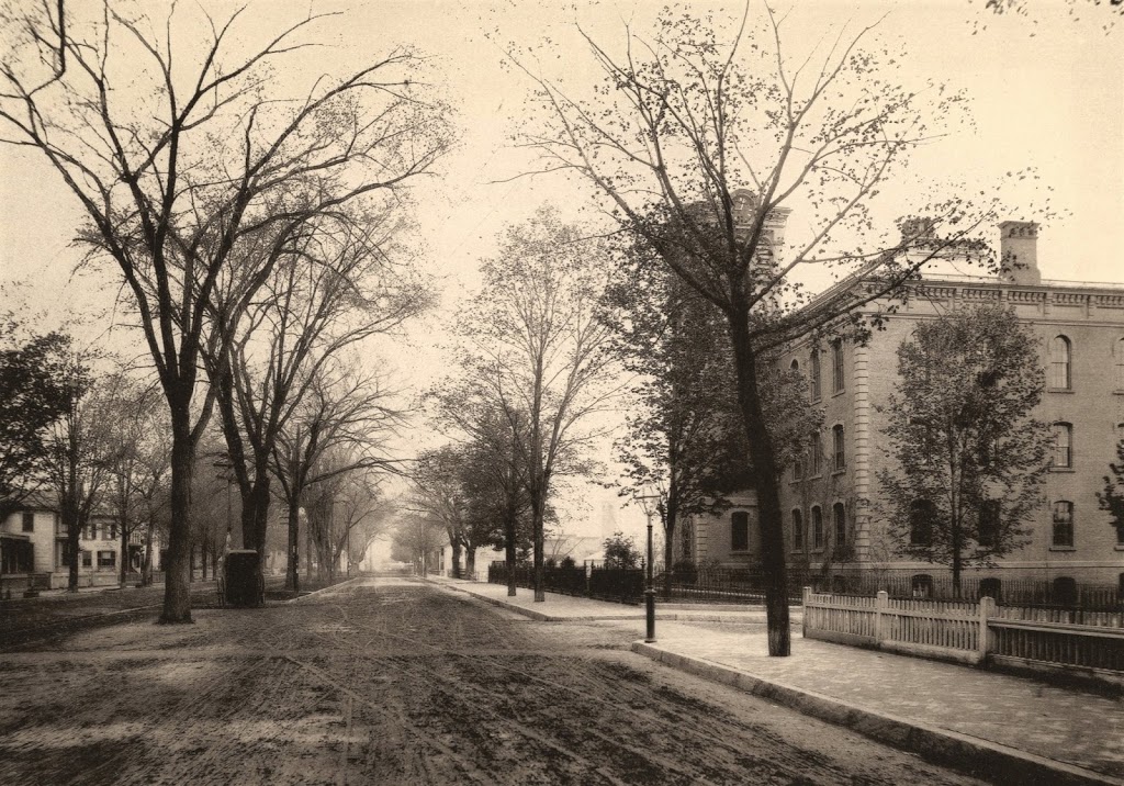
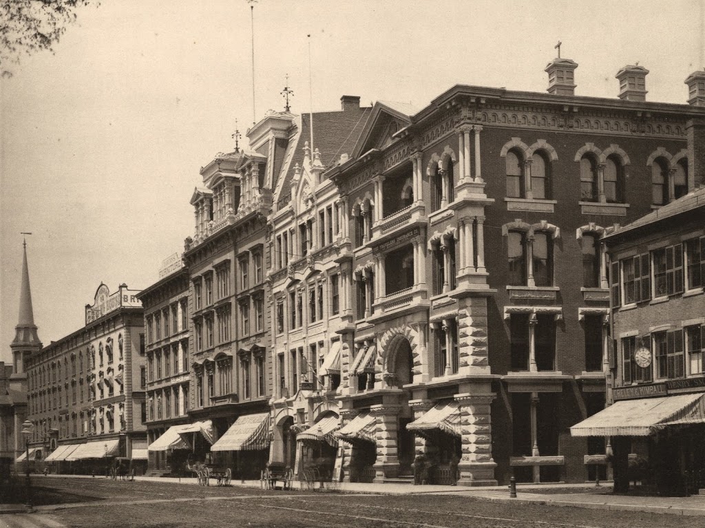
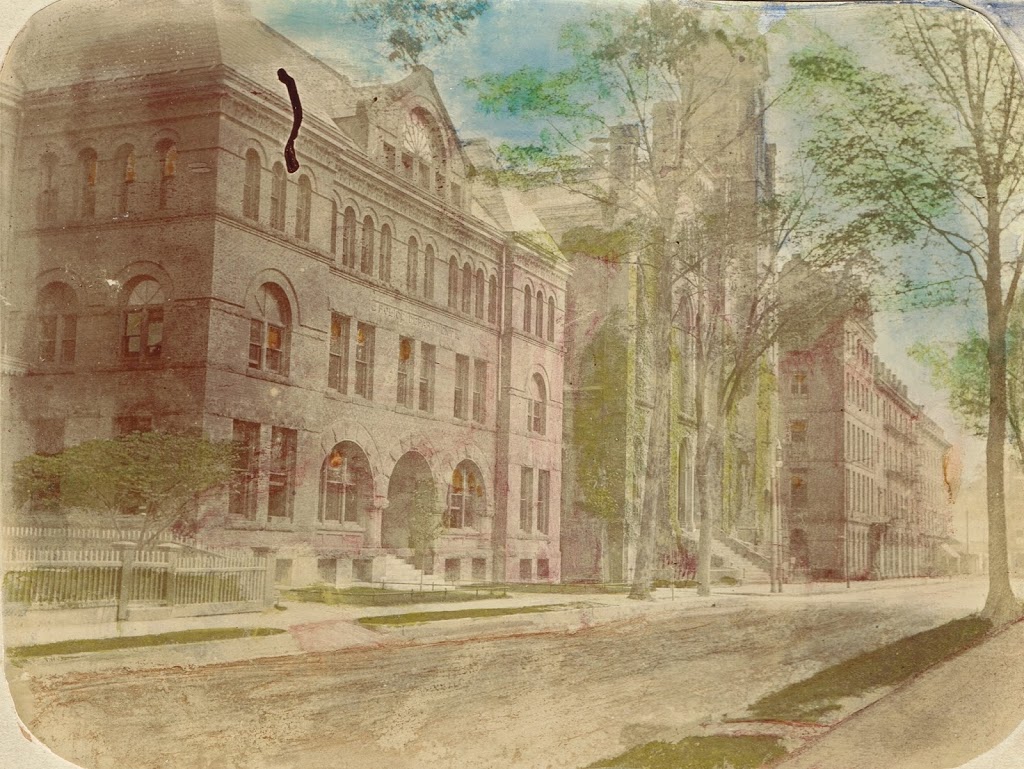
Court Street in Springfield, sometime before 1905. Photo from author’s collection.

444_1900c-2Bpersonalcollection

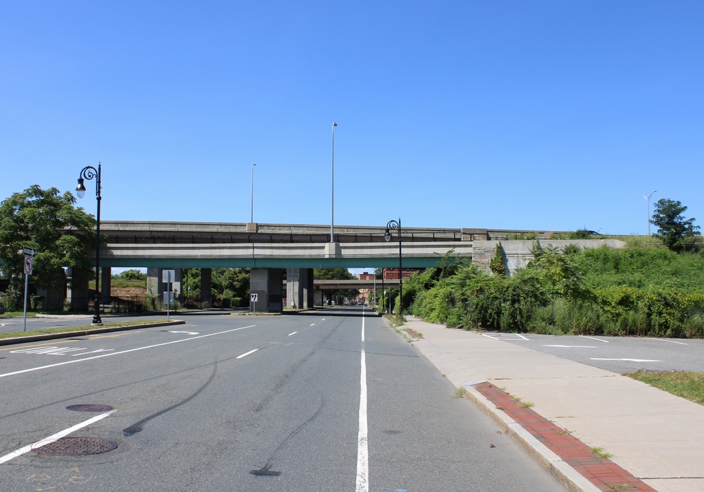
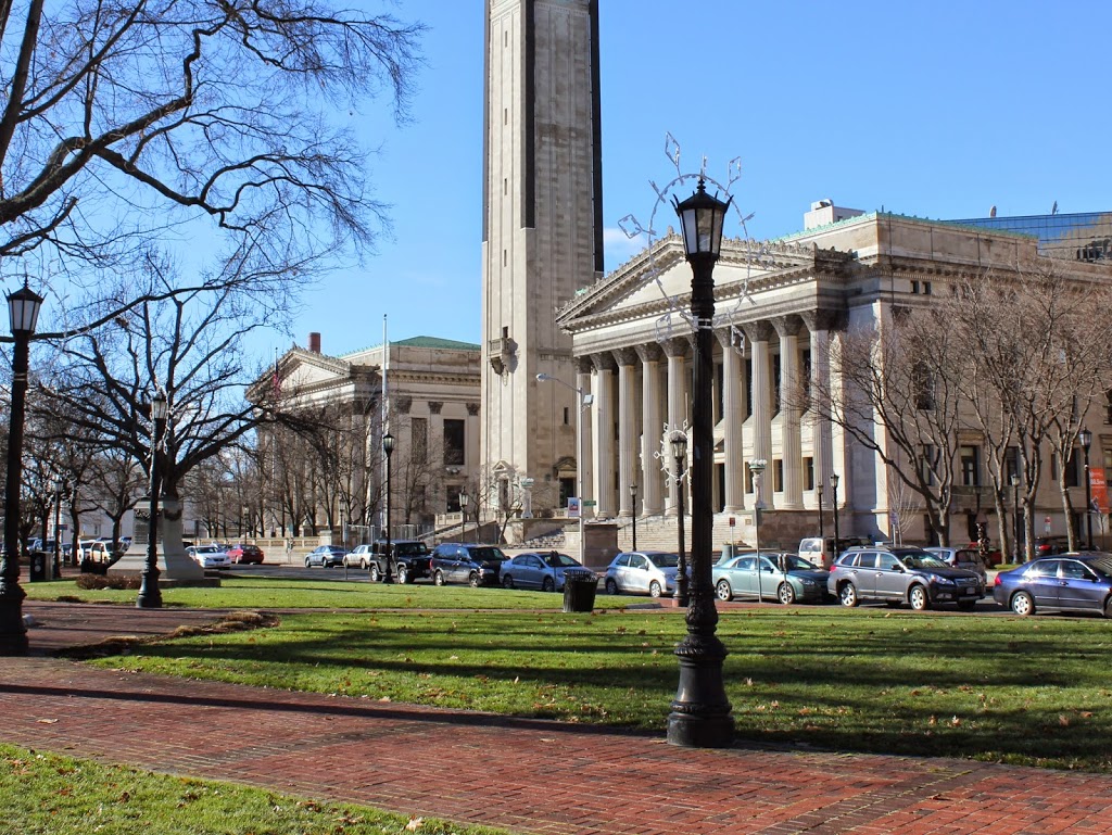
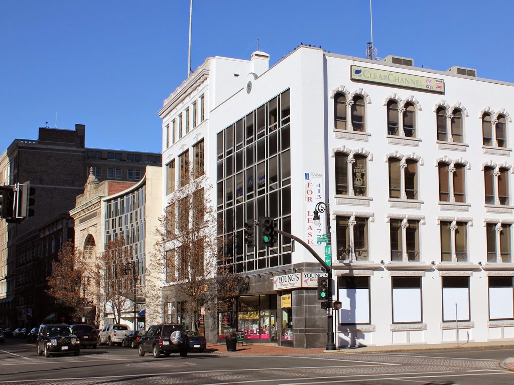
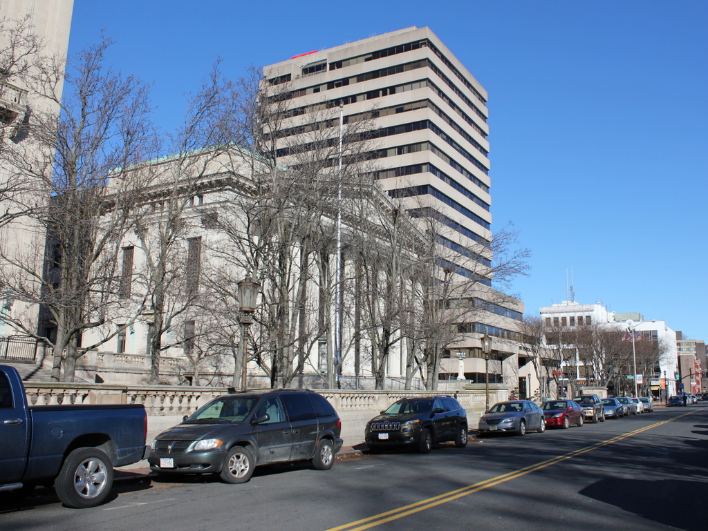
Court Street in 2014:

444_2014

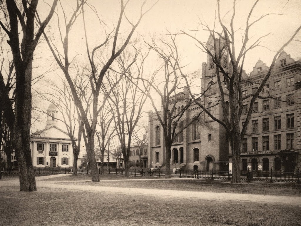
I came across the first photo in a 3-for-$1 bin at an antique store, and despite the odd coloring it provides an interesting view along Court Street from around the turn of the last century.  It is an albumen print, mounted on thick paper, and evidently colorized after processing.  There are no identifying marks on the photo, and the only way I was able to figure out the location was because I recognized the old police station and City Hall as being in Springfield.  My guess is that it was probably taken sometime in the 1890s, but it could’ve been anytime before 1905, when the old City Hall burned down.

To the left of City Hall, in the foreground of the first photo, is the old police department headquarters, which was later demolished to make way for the Springfield Municipal Group.  The new City Hall, which was completed in 1913, is still there, on roughly the same spot that its predecessor stood in the first photo.  The site of the former police station is now the area between City Hall and Symphony Hall, where the campanile tower is.  In the background, One Financial Plaza building looms over City Hall, between City Hall Plaza and Main Street.  The only building in the present-day scene that would’ve even existed when the first photo was taken is the former Springfield Five Cents Savings Bank building at the corner of Main and Court Streets, although its Main Street facade has been altered beyond recognition.

Hampden Park from Round Hill, Springfield, Mass

The view of Hampden Park from the North End of Springfield, around 1882. Photo from Springfield Illustrated (1882).

440_1882c-2Bspringfieldillustrated

The view in 2014:

440_2014

The location of the second photo isn’t exact – the actual location would be somewhere in the southbound lane of Interstate 91, so I did the next best thing; I took the 2014 photo from a bridge over the highway.  Either way, not much remains the same today.  The railroad tracks are still there, as is the Connecticut River, but otherwise it’s a completely different scene.  Hampden Park is visible in the distance; this was home to bicycle races, minor league baseball games, and even the occasional college football game.  A more in-depth history of the park is explained in this post.

In later years, the part of Hampden Park closest to the North End Bridge became Pynchon Park, and was the home of several different minor league teams until the 1960s.  Today, the former site of Hampden Park is now primarily industrial, with warehouses and other facilities on the spot where Harvard and Yale used to play early college football games.  Pynchon Park is now a Pride station, and can barely be seen through the trees just to the left of the billboard on the right-hand side of the photo.

North Main Street, Springfield, Mass

Main Street in Springfield, looking toward the North End near Congress Street, around 1882. Photo from Springfield Illustrated (1882).

439_1882c-2Bspringfieldillustrated

The scene in 2023:

The only readily identifiable building in the first photo is on the right side of Main Street, the Hooker School, which was a grammar school that opened in 1865.  In the 1884 King’s Handbook of Springfield, it is described as “the finest of the grammar-school buildings in external appearance,. for which it is indebted to its imposing tower (containing a clock with illuminated dial), as well as to the beautiful network of vines which in summer relieve the bareness of its brick walls.”

The building continued to be used as a grammar school until 1918, and it subsequently became the Continuation School, and then as the girls’ division of the Trade School. It finally closed in 1940, and it was demolished in 1944. Then, about 20 years later most of the surrounding area was demolished as part of an urban renewal plan, which included constructing a large interchange between Interstates 91 and 291, as shown in the second photo.

Court Square, Springfield, Mass

Court Square in Springfield, around 1882. Photo from Springfield Illustrated (1882).

438_1882c-2Bspringfieldillustrated

Court Square in 2014:

438_2014

The 1882 photo clearly shows Springfield’s old City Hall, which burned down in 1905 and was replaced in 1913 by the present City Hall, Symphony Hall, and Campanile tower.  On the far left of the old photo is the former Hampden County Courthouse, which by 1882 was being used by the Odd Fellows.  Today, the only constant between the two photos is Court Square itself; none of the buildings seen in the 1882 view are still there.  Even the Miles Morgan statue hadn’t yet been brought to Court Square, although it would within a year or so.

Main & Court Streets, Springfield, Mass

Looking north on Main Street in Springfield, toward Court Street, around 1882. Photo from Springfield Illustrated (1882).

1880s

Main Street in 2014:

437_2014

This scene is similar to the view in this post, except this one shows the view further down Main Street.  The building in the foreground is the home of the Springfield Five Cents Savings Bank, which is still there today, although its Main Street facade has been completely replaced.  However, the arches over the windows on the Court Street side clearly show that it is the same building.  Further down Main Street in the 1882 photo is the home office of the Springfield Republican, and beyond that is the Mass Mutual Building.

The commercial block furthest from the camera is the Union Block, which is seen in this post from the other side.  Two thirds of this building still exists today, although it is hard to see it in the shadows of the 2014 photo.  Finally, the steeple of the First Baptist Church, which can be seen more clearly in this post.  The church was built in 1847 and demolished in 1888, and today its former location is now Harrison Avenue where it intersects with Main Street.

State Street, Springfield, Mass

State Street in Springfield, looking toward St. Michael’s Cathedral around 1882. Photo from Springfield Illustrated (1882).

436_1882c-2Bspringfieldillustrated

State Street in 2014:

436_2014

This view is similar to the scene in this post, but here we see a little more along the north side of State Street.  Several buildings are still there, including the 1860s St. Michael’s Cathedral and the rectory next to it.  Further up State Street in the 1882 scene, the Alexander House is visible in the distance.  This historic house was moved in 2003 to make way for the construction of the new federal courthouse, although it is still visible in the 2014 photo, in the distance between the church and the rectory.