Old MIT Campus, Boston

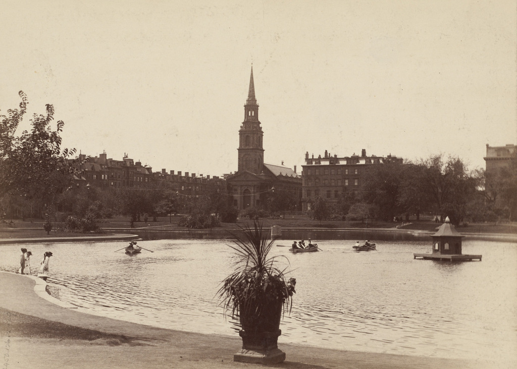
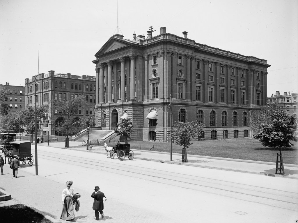
The former Massachusetts Institute of Technology campus, looking west on Boylston Street from near Berkeley Street in Boston, around 1890-1901. Image courtesy of the Library of Congress, Detroit Publishing Company Collection.
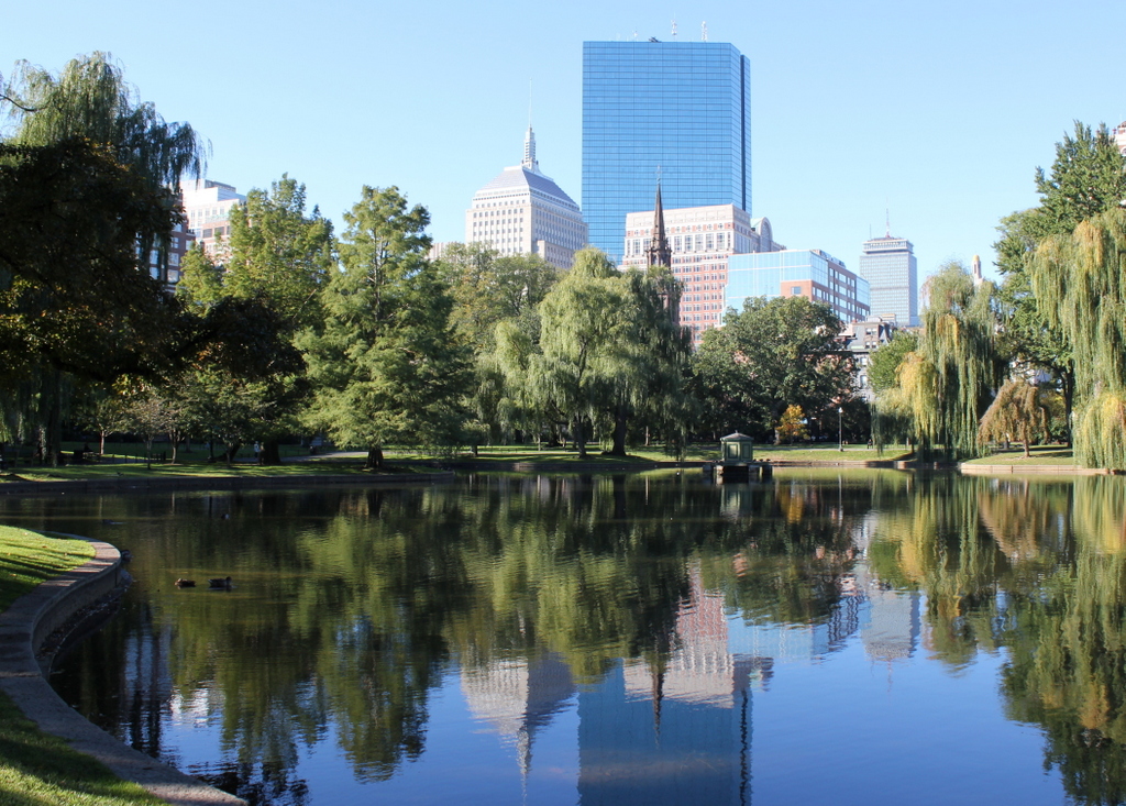
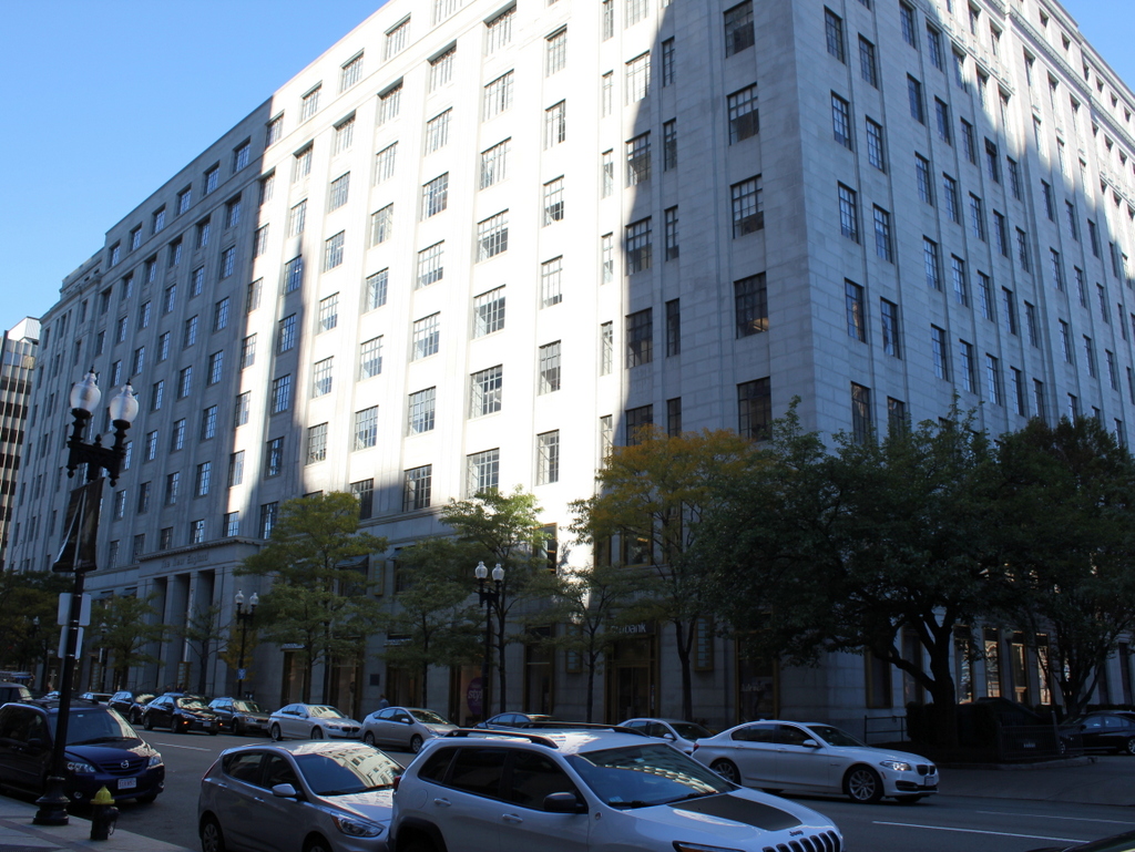
808_1890-1901c loc

The scene in 2015:

808_2015
The first permanent home for Massachusetts Institute of Technology was in this building in the foreground. Completed in 1866 and later named the Rogers Building in honor of the school’s founder, it matched the architectural style of the adjacent Museum of Natural History, which is still standing today just to the right of here. The school was established to fill a need for a college education that focused on modern developments in science and technology, and despite some initial challenges such as the Civil War in the 1860s and an economic recession in the 1870s, the school began to grow. In 1883, the campus expanded with the Walker Building, which can be seen to the left in the first photo, at the corner of Clarendon Street. Even this was not enough, though; from 1881 to 1897 enrollment nearly quadrupled, and by the early 1900s the school was spread out across 10 buildings in the Copley Square area.

In 1916, most of the school moved to a new campus across the river in Cambridge, although the Rogers Building was retained as the home of the School of Architecture until the 1930s, when it was sold to the New England Mutual Life Insurance Company. Both the Rogers and Walker Buildings were demolished in 1939, and the insurance company built their new headquarters here, as seen in the 2015 photo. New England mutual merged with Met Life in 1995, and today their former headquarters is mixed-use building with retail and office tenants.

George Washington Statue, Public Garden, Boston

The side view of the George Washington statue in the Boston Public Garden, facing north toward Beacon Street, sometime in the 1800s. Image courtesy of the Boston Public Library.

802_1800sc bpl

The statue in 2021:

As mentioned in this earlier post, this statue of George Washington has stood at the Commonwealth Avenue entrance to the Public Garden since 1869. It was designed by sculptor Thomas Ball, a Boston native who also designed the Charles Sumner statue in the Public Garden, and the Emancipation Memorial at nearby Park Square. Since then, not much has changed about the statue or the surrounding park. The trees now obscure the view of the houses in the distance, but many of them are still standing today, along Arlington Street to the left and Beacon Street in the center and right.

Public Garden, Boston (2)

Looking west from the bridge in the Boston Public Garden toward Commonwealth Avenue in 1895. Image courtesy of the Boston Public Library.

801_1895 bpl

The scene in 2015:

801_2015
For as much as Boston has changed in the past 120 years, this scene has stayed remarkably the same. It is taken facing the opposite direction from the photos in this post, and the statue in the distance is the same one visible from the other side in that post. This bridge over the lake has been a feature in the Public Garden since it was added in 1867, and it was designed by noted Boston architect William G. Preston. Two years later, the statue of George Washington was added, and it is one of many statues that decorate the park.

Beyond the Public Garden is the eastern end of Commonwealth Avenue, which was designed with a wide, park-like median. It serves as a major centerpiece for the Back Bay neighborhood, and the townhouses on either side of the street have been highly coveted since the area was first developed. Many of these historic homes are still standing today, although it is hard to see in the 2015 photo here. The ones to the left, at the corner of Commonwealth Avenue and Arlington Street, have since been demolished and replaced by a modern high-rise, but most of the ones on the right are still there, including the ones at the corner. Built mostly in the 1860s, these are among the oldest homes in the Back Bay, and this location along the Commonwealth Avenue Mall and across from the Public Garden has long been desirable real estate in the city.

Public Garden Lake, Boston

Looking west across the lake in the Boston Public Garden, sometime in the late 1800s. Image courtesy of the Boston Public Library.

800_1877-1910c bpl

The view in 2015:

800_2015
Boston’s Public Garden, as mentioned in this post, was the first public botanical garden in the United States when it was established in 1837. It was located along the edge of the city’s original shoreline, and like the rest of the Back Bay it was a tidal marsh when European settlers first arrived in 1630. By the 1850s, though, the city was looking to expand west by filling in the Back Bay, and one of the initial projects was the landscaping of the Public Garden, which was done in the early 1860s by landscape architect George Meacham.

In the years since the first photo was taken, the Public Garden itself hasn’t changed much. It still has the artificial lake in the center, surrounded by walkways, flower beds, and statues. The lake’s famous swan boats are not visible here, but they began operation in 1877 and are still in use during the summer months. Also not visible from here is the bridge over the lake, which was added in 1867 a little to the right of this scene, and is still there today.

The greatest difference between these two photos, obviously, is the skyline beyond the Public Garden. When the first photo was taken, the eastern portion of the Back Bay had been developed, and the Arlington Street Church, built in 1861, was the most obvious landmark in this scene. The church is still standing, as are the townhouses just to the right of it along Arlington Street, but otherwise all of the other buildings from the first photo are gone. The buildings to the left of the church are on Boylston Street, and most of the Victorian townhouses were demolished long ago as the street became an important commercial area. In the distance, skyscrapers such as the old and new John Hancock buildings and the Prudential Tower show how the southern section of the Back Bay has been extensively redeveloped starting in the second half of the 20th century.

Whip Factories on Elm Street, Westfield, Mass

Looking north on Elm Street in Westfield, toward the intersection of Franklin Street, around 1890-1895. Image courtesy of the Westfield Athenaeum.

799_1890-1895 westfieldath

Elm Street in 2015:

799_2015
As mentioned in a previous post, Westfield was once the world’s leading producer in whips. When the first photo was taken, there were some 37 whip factories in the city, and by the start of the 20th century they combined to produce 99% of the world’s supply of whips. Two of these companies were photographed here; in the foreground to the right was the New England Whip Company, and just beyond it, in the much larger building with the tower, was Cargill, Cook & Co. Beyond these two factories were several other brick buildings, all of which were probably built around the 1870s or 1880s, just as Westfield’s whip industry was reaching its peak.

The whip industry was a boon to the entire city, but the lack of diversity in Westfield’s economy was felt as the whip factories started closing in the early 1900s. Automobiles had largely replaced horse-drawn carriages, which meant little demand for the city’s whips. Some of the historic whip factory buildings were later repurposed and are still standing in Westfield, but the ones in the first photo have since been demolished, and there is now a gas station on the site. The Swift Building, a three story brick building barely visible at the far end of the row of buildings in the first photo, is the only one left from the 1890s view. Otherwise, the only surviving structure from the first photo is the railroad trestle in the distance. There have not been any trains along this track for many years, but the right-of-way is in the process of being converted into a rail trail.

Lenox Academy, Lenox, Mass

The Lenox Academy building on Main Street in Lenox, sometime around the 1800s. Image courtesy of the Lenox Library Association.

792_1800sc lenoxlibraryassociation

The building in 2015:

792_2015
Lenox Academy was established in 1803 as a private school, and this building was built around that time. The school closed in 1866, and the building was used as the town’s public high school from 1869 to 1879, and again from 1886 to 1908. In between, the building was renovated and moved to a new foundation in 1879. The first photo appears to have been taken sometime after this move, probably in the 1880s or 1890s. The last school to use this building was the private Trinity School, which was here from 1911 until the 1920s. After that, it was vacant until 1947, when it was sold to the town of Lenox to protect it from demolition. It was added to the National Register of Historic Places in 1982, and it is now the home of the the Lenox Historical Society and the Lenox Historical Commission.