Collins Inn, Wilbraham, Mass

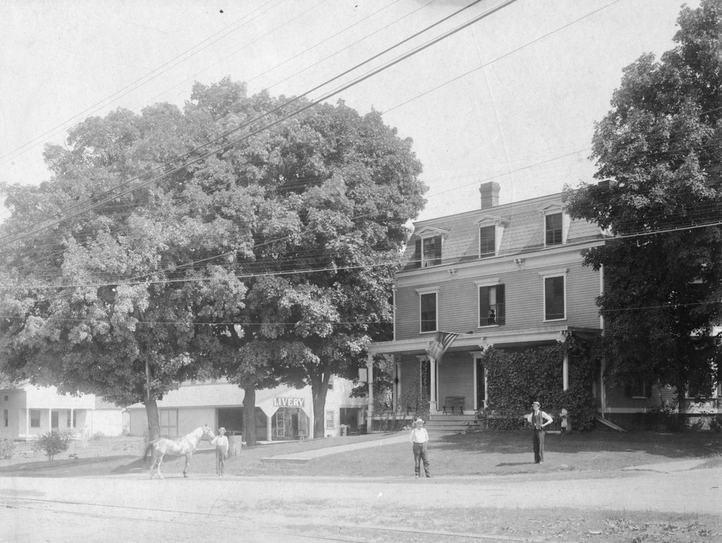
Collins Inn at the corner of Boston Road and Chapel Street in North Wilbraham, probably in the 1890s or early 1900s.  Image courtesy of the Wilbraham Public Library.
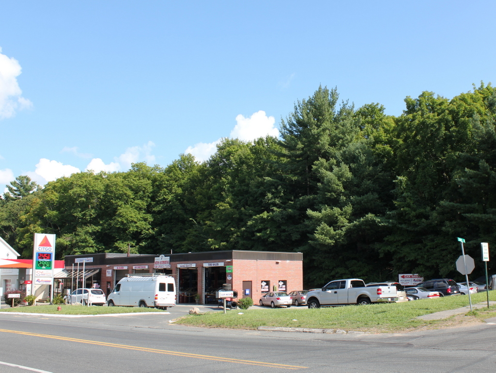
742_1800sc wpl

The scene in 2015:

742_2015
The historic center of the town of Wilbraham has always been along Main Street in the town’s approximate geographic center.  When it was first settled in the 1700s, this was the ideal place for farming, but as changes in industrialization, transportation, and communication came about in the 1800s, the village of North Wilbraham gained prominence.  Its location on the banks of the Chicopee River and along the main road from Springfield to Boston made this area an important spot for industry and transportation.  In 1839, the Boston & Albany Railroad opened through here, with the North Wilbraham railroad station being located right across the street from here.

The building in the foreground of the first photo was the Collins Inn, which was opened in 1874 by Warren L. Collins.  It sat directly across Boston Road from the railroad station, and across Chapel Street from the Hollister Block, which at the time was used as a drugstore and post office.  In addition to the inn, Collins also operated a livery stable on the site, and ran a stagecoach line from here to the center of Wilbraham, about two miles away.

Aside from transportation, though, the Collins inn also offered Wilbraham another connection to the outside world – the telephone.  The telephone was invented in 1876, and within just four years a line was established from here to the center Wilbraham, at a cost of $30 per year for subscribers.  However, a few years later the cost increased to $100 per year (equivalent to over $2,400 today), and the service was discontinued because of a lack of families willing to pay.  When phone service was re-established in 1904, the Collins Inn became the town’s telephone exchange office for the New England Telephone and Telegraph Company, serving 21 customers in Wilbraham.

The telephone exchange remained here until 1914, when it moved to a different building across the street.  Around the same time, the Collins Inn closed, although the building itself remained standing for some time.  The 1964 History of Wilbraham book indicates that it was still standing at the time, although today its former location is now a parking lot.

Portland Head Light, Cape Elizabeth, Maine (2)

Another view of Portland Head Light, taken from the north side probably around 1890. Image courtesy of the Library of Congress, Detroit Publishing Company Collection.

740_1900-1910c loc
The lighthouse in 2015:

740_2015
The angle here isn’t exact; the first photo was taken from the water, a little to the left of where the 2015 photo was taken.  The previous post explains more about the history of the lighthouse, which was built in 1791 on a rocky outcropping at the entrance to Portland Harbor.  The first view was presumably taken around the same time as the one on the other post, because it shows the old 1816 keeper’s house, which was replaced by the current one in 1891.

Being surrounded by water on three sides and facing the open ocean provides some dramatic views for visitors and photographers, and it probably also provided the inspiration for Henry Wadsworth Longfellow’s poem “The Lighthouse.”  Longfellow grew up in Portland, and the certainly seemed to be describing this lighthouse, writing in the first two stanzas:

The rocky ledge runs far into the sea,
And on its outer point, some miles away,
The Lighthouse lifts its massive masonry,
A pillar of fire by night, of cloud by day.

Even at this distance I can see the tides,
Upheaving, break unheard along its base,
A speechless wrath, that rises and subsides
In the white lip and tremor of the face.

The lighthouse would have looked a little different when Longfellow wrote the poem, though.  The keeper’s house would have been the same as the one in the first photo, but as mentioned in the previous post, its height was periodically changed throughout the 19th century, and did not assume its present-day appearance until 1885, three years after Longfellow’s death.  Today, with the old keeper’s house gone, the only thing left from Longfellow’s childhood visits is the section of the tower below the horizontal band a little below the lantern.

Portland Head Light, Cape Elizabeth, Maine (1)

The view of Portland Head Light, possibly around 1890. Image courtesy of the Library of Congress, Detroit Publishing Company Collection.

739_1902c loc

The lighthouse in 2015:

739_2015
Aside from perhaps lobsters and pine trees, Portland Head Light is one of Maine’s most recognizable symbols.  The iconic lighthouse is among the most famous in the world, and in the past few years it has been featured in lists such as USA Today’s “10 best lighthouses around the USA“, The Weather Channel’s “11 Amazing Lighthouses of the World“, and Mental Floss’s “10 of the Most Beautiful Lighthouses in the World.”  However, this is not a recent phenomenon; the picturesque lighthouse overlooking Portland’s Casco Bay has attracted generations of photographers, as seen in the photo from the Detroit Publishing Company over a hundred years earlier.

The lighthouse was completed in 1791, in what was at the time part of Massachusetts.  As its name suggests, Portland was, and still is, one of New England’s major commercial ports, so a lighthouse was needed to mark the southern edge of the main shipping channel into the harbor. It was the first lighthouse to be built by the United States government (all earlier lighthouses were built prior to the Revolution or prior to the federal government assuming control over lighthouses), and it was also the first of many lighthouses in present-day Maine.

As built, Portland Head Light looked very different from today.  It was only 72 feet tall, but poor construction of both the tower and the keeper’s house became evident within 20 years.  The leaking lighthouse was lowered by 20 feet in 1812, and the keeper’s house was replaced in 1816 by the one seen in the first photo.  This website provides more details, along with a few historic photos of the lighthouse, including one from 1859 that is barely recognizable compared to the two views shown above.

The tower’s height continued to fluctuate throughout the 19th century.  In response to a deadly 1864 shipwreck, it was raised 20 feet for better visibility, only to be reduced again in 1883.  Two years later, though, the third and final height change gave the tower its present appearance.  This is still noticeable today; the ring around the upper section of the tower separates the 1885 addition from the original 1791 structure.

The only obvious difference between the two photos above is the keeper’s house to the left, and this is where there is somewhat of a discrepancy with the date of the photo.  The Library of Congress estimates that the first photo was taken around 1902. However, the records indicate that the present-day keeper’s house was built in 1891, and assuming this is correct, it would make that the earliest that this photo could have been taken.  This is far earlier than most of the other photos in the Detroit Publishing Company collection, though, so the exact date seems to be questionable.

Date questions aside, the lighthouse is still an active aid to navigation for one of the busiest ports on the east coast, although the keeper’s house is no longer used as a residence.  The light was automated in 1989, eliminating the need for a full-time lighthouse keeper. so today the house is owned by the town of Cape Elizabeth, and is operated as a maritime museum as part of Fort Williams Park.

First Baptist Church, Boston

The First Baptist Church in Boston, at the corner of Commonwealth Avenue and Clarendon Street in the Back Bay, as seen around 1890-1901. Image courtesy of the Library of Congress, Detroit Publishing Company Collection.

717_1890-1901c loc

The church in 2015:

717_2015
The First Baptist Church was one of many prominent Boston churches that relocated to the Back Bay in the late 1800s, although this building wasn’t originally built for them.  It was designed by Henry Hobson Richardson, whose later works would include Trinity Church a few blocks away at Copley Square.  The top of the tower features carvings by French sculptor Frédéric Auguste Bartholdi, who also designed the Statue of Liberty.  The building was completed in 1875 for Brattle Street Church, a Unitarian church that had previously been located where City Hall is today.  However, the church didn’t last long here; they disbanded in 1876 and sold their new building to the First Baptist Church in 1882.  They are one of the oldest Baptist congregations in the country, dating back to 1665, and they are still located here on Commonwealth Avenue over 130 years later.

Museum of Fine Arts, Boston

The old Museum of Fine Arts building at Copley Square in Boston, probably sometime in the 1880s. Image courtesy of the Boston Public Library.

716_1876-1895 bpl

The building around 1890-1901. Image courtesy of the Library of Congress, Detroit Publishing Company Collection.

716_1890-1901c loc

The location in 2015:

716_2015
Boston’s Museum of Fine Arts was established in 1870, and six years later it moved into this Gothic Revival building on the south side of Copley Square.  Because of the museum’s presence here, it was originally named Art Square, but in the 1880s it was renamed in honor of colonial Boston painter John Singleton Copley.  The museum has a substantial collection of his works, including portraits of prominent figures such as John Adams, Samuel Adams, John Hancock, and Paul Revere.

In 1909, the museum relocated further down Huntington Avenue in the Fenway-Kenmore neighborhood, on a larger plot of land that allowed for more expansion as the museum grew.  Today’s museum is many times larger than the original Copley Square building, and it is among the most visited art museums in the world, attracting over a million visitors each year.  The old art museum was demolished soon after the museum moved, and in 1912 the Copley Plaza Hotel, which is still standing today, was built on the site.

Copley Square, Boston (2)

Copley Square as seen from in front of the New Old South Church in Boston, in 1893. Image courtesy of the Boston Public Library.

695_1893 bpl

Copley Square in 2015:

695_2015
The first photo shows Copley Square as it appeared only about 20 years after this section of Boston was developed.  In the second half of the 19th century, the Back Bay was transformed from a polluted marsh to one of the city’s premier neighborhoods.  Many of the city’s important cultural institutions moved here, with many of them surrounding the Copley Square area, including the New Old South Church on the left, the Trinity Church in the center, and the Museum of Fine Arts on the right.  Also under construction, but just out of view of the camera on the right, was the main branch of the Boston Public Library.

Today, the Copley Square area has seen some significant changes from the 19th century.  It remains the focal point of the Back Bay, but what started as neighborhoods of Victorian rowhouses evolved into low-rise commercial buildings, and eventually modern skyscrapers, especially in the area south of Boylston Street.  The two churches from the 1893 photo are still standing, but all of the other buildings are gone, including the Museum of Fine Arts, which moved to a larger facility further down Huntington Avenue in the early 1900s.  The old building was demolished, and replaced in 1912 with the Copley Plaza Hotel, which still stands today.

The most prominent new building in the 2015 scene is the John Hancock Tower, which was completed in 1976 and is the tallest building in New England.  Beyond it, near the center of the photo, is the 1947 Berkeley Building, which is also known as the Old John Hancock Building.  Together, these skyscrapers, along with the ones seen facing the other direction in this post, make up Boston’s High Spine, a string of skyscrapers extending west from downtown Boston, roughly along the Boylston Street and the Massachusetts Turnpike.