Pearsons Hall, South Hadley, Mass

Pearsons Hall on the campus of Mount Holyoke College in South Hadley, around 1900-1910. Image courtesy of the Library of Congress, Detroit Publishing Company Collection.

567_1900-1910 loc

Pearsons Hall in 2015:

567_2015
Mount Holyoke College was established in 1837 as the Mount Holyoke Female Seminary, and for most of the 19th century a single building, known as the Seminary Building, housed most of the classrooms and dorm rooms, as well as the library and gymnasium. However, it burned in 1896, and the following year the school built four new dormitories, one of which was Pearsons Hall.  It is named for Dr. D.K. Pearsons, who donated money to the school to help rebuild following the fire.  Today, the building is still there, and it continues to be used as a dormitory for the college.

Civil War Monument, South Hadley, Mass

The Civil War monument on the town common in South Hadley, around 1900-1910. Image courtesy of the Library of Congress, Detroit Publishing Company Collection.

566_1900-1910 loc

The monument in 2023:

There are several things that almost every New England town center has: some sort of a town common, and a Civil War monument on that common. South Hadley is no exception, with its granite statue honoring “the loyalty and patriotism of our citizen soldiers who fought for liberty and the Union in the great rebellion of 1861-1865,” as the inscription on the front reads.  South Hadley had 224 of its citizens fighting in the war, many of whom were probably still living here when the monument was dedicated in 1896.

Northampton from Mount Holyoke, Hadley Mass

Looking west from the summit of Mount Holyoke toward Northampton, around 1900. Image courtesy of the Library of Congress, Detroit Publishing Company Collection.

564_1900c loc

The scene in 2015:

564_2015
Not a whole lot has changed in this scene in the past 115 years. From this distance, there aren’t too many noticeable changes in the city of Northampton, which has grown in population by more than 50% since 1900. The area near the river has hardly changed at all; this floodplain continues to be used as farmland.  Even Interstate 91, which passes through between the farms and the city, isn’t noticeable in the present-day scene.  In fact, the only really obvious difference here is something that is entirely natural – the island that has formed in the middle of the Connecticut River.

Connecticut River from Mount Holyoke, Hadley Mass

Looking north toward the Connecticut River from the summit of Mount Holyoke around 1900. Image courtesy of the Library of Congress, Detroit Publishing Company Collection.

565_1900c loc

The scene in 2015:

565_2015
One of the things that amazes me about then and now landscapes of New England is the difference in trees.  It seems counterintutitive, but in most cases the present-day scenes are substantially more forested than they were in the past.  In part, this is because of agricultural changes over the past century.  This section of the Connecticut River Valley has some of the best farmland in New England, and there are still plenty of active farms today, but New England’s short growing season and limited land has prevented the area from being used for large-scale farming.  Today, some of the former farms have been developed into residential neighborhoods, but much of the land, especially in the floodplains along the river, has reverted to forest over the course of the past century.

The Oxbow from Mount Holyoke, Hadley Mass

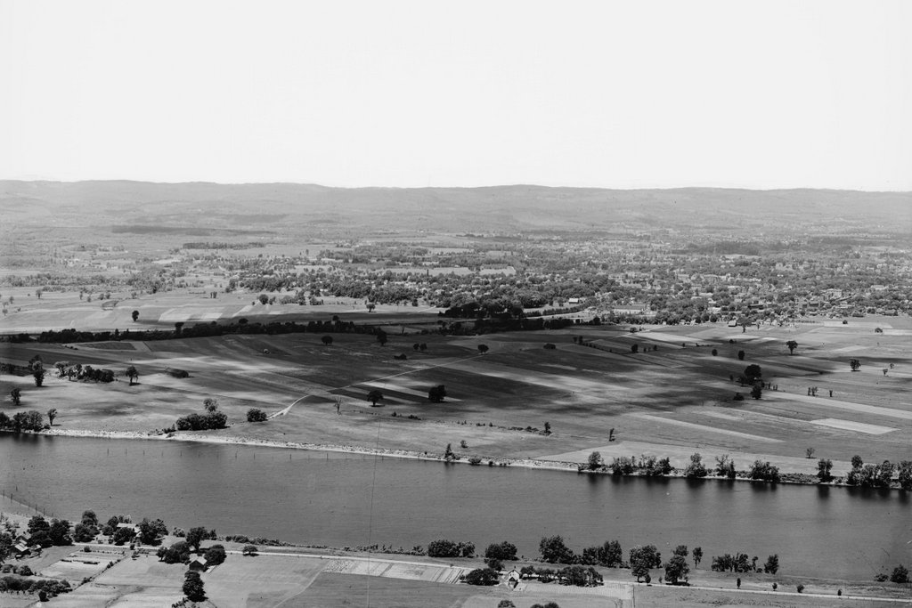
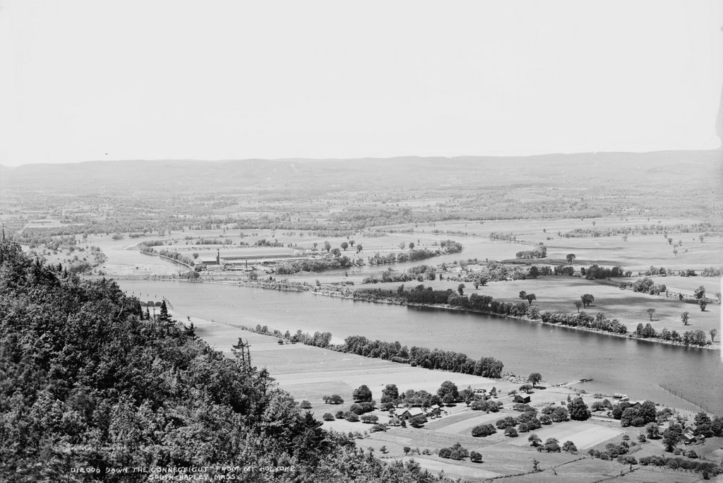
The view looking southwest from the Mount Holyoke Summit House around 1900. Image courtesy of the Library of Congress, Detroit Publishing Company Collection.
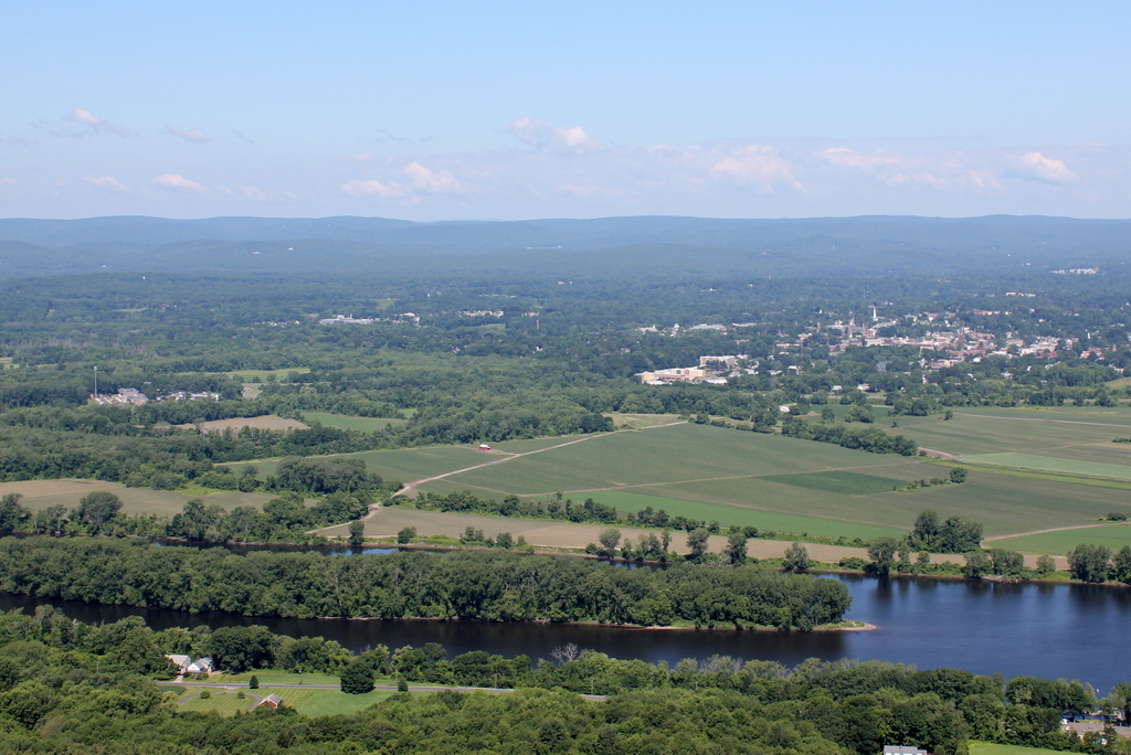
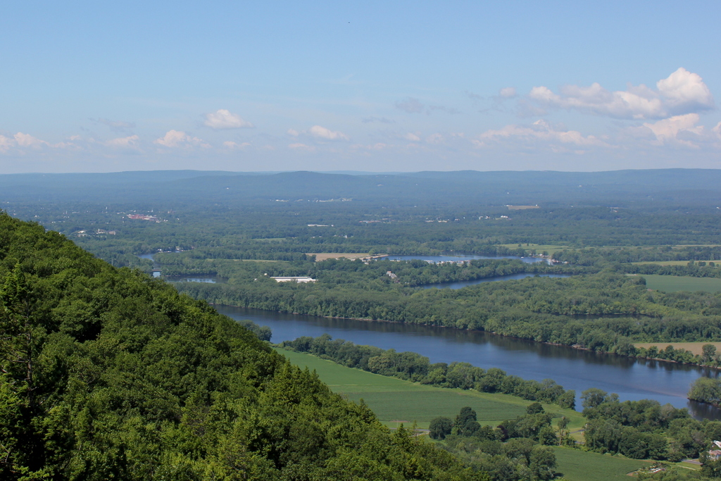
563_1900c loc

The scene in 2015:

563_2015
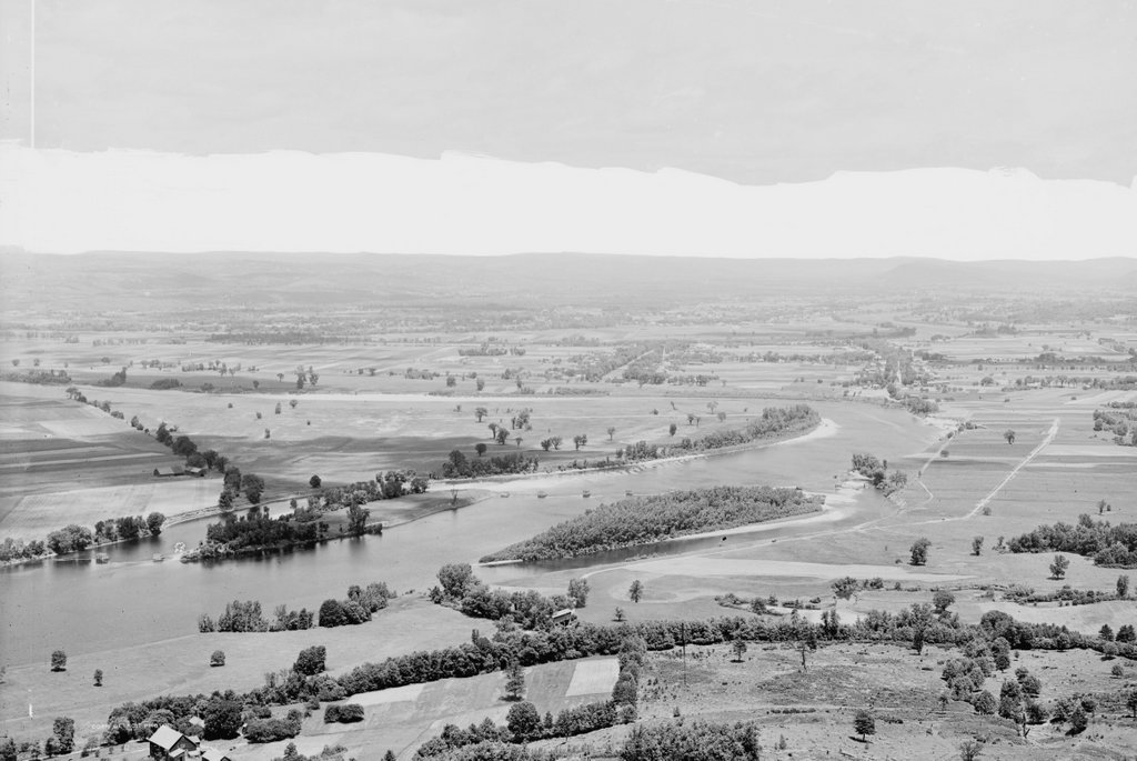
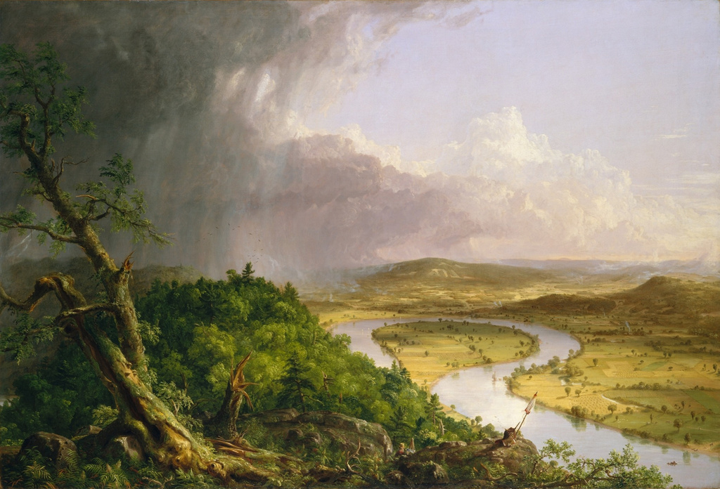
This scene from the summit of Mount Holyoke was made famous in 1836 when artist Thomas Cole painted “View from Mount Holyoke, Northampton, Massachusetts, after a Thunderstorm,” a work also known as “The Oxbow” because of the prominent meander in the river.  Cole’s depiction of the scene is below:

Cole_Thomas_The_Oxbow_(The_Connecticut_River_near_Northampton_1836)
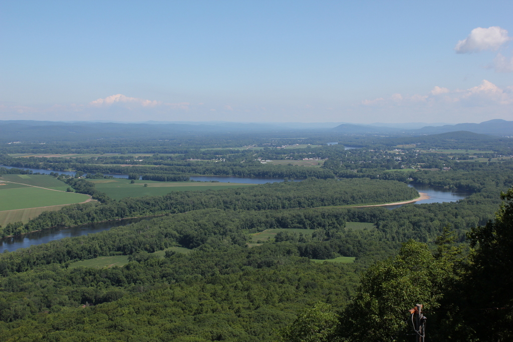
The top of Mount Holyoke has long been a sightseeing destination, starting even before Cole’s 1830s visit.  In 1821, a small cabin was built at the summit, which was replaced in 1851 by a much larger hotel, which still stands today.  The 2015 photo, and presumably the 1900 photo, were both taken from the porch that surrounds the building, and they reveal some of the changes that have occurred in the landscape over the past 115 years.  However, probably the most obvious change here occurred long before the first photo was taken, and not long after Thomas Cole painted his famous work.  In 1840, a flood broke through the narrow neck, giving the Connecticut River a more direct route downstream and turning the former riverbed into a lake.  It also made travel easier; traffic no longer had to follow the meandering river, and the 1900 scene shows the railroad tracks that had been built across what was once the river.  Today, Route 5 parallels the railroad tracks, and Interstate 91 crosses the Oxbow just a little further to the west.

When the 1900 photo was taken, the Oxbow played an important role in river commerce as a holding place for logs that were floated downstream.  Each spring in the late 1800s and early 1900s, logs from upstream in Vermont and New Hampshire would be floated down the river to the paper mills in Holyoke.  Since it is just a short distance upstream of Holyoke, the Oxbow made for a convenient holding place away from the main channel of the river.  The last such log drive occurred in 1915, and since then it has been used primarily for pleasure boats, with the Oxbow Marina located on the inside of the curve.  There are no dams between Holyoke to the south and Turners Falls to the north, so this section is one of the busiest on the Connecticut River for recreational boating.

Springfield and Eastern Street Railway, Palmer Mass

A Springfield and Eastern Street Railway trolley in downtown Palmer, on Main Street opposite Bridge Street, in 1905. Image courtesy of the Palmer Public Library.

561_1905 palmerhistcom

The scene in 2015:

561_2015
The town of Palmer was once a major transportation hub, as indicated by its nickname, the “Town of Seven Railroads.” Although not all of these railroads were ever operational, at the time that the first photo was taken there were five different railroads operating in the town, but that didn’t include the many trolley lines that also served Palmer. The trolley line along Main Street belonged to the Springfield and Eastern Street Railway, and it connected Monson, Brimfield, and other points east to the city of Springfield, some 15 miles to the west. The line opened in 1898 as the Palmer and Monson Street Railway, and connected the two rapidly developing industrial towns. In 1901, the line was extended to connect with the Springfield Street Railway, and in 1905 the company was renamed to reflect its role in connecting Springfield to the towns to the east.

The first few decades of the 20th century were the heyday for trolleys, but as time went on they faced competition from buses and automobiles.  The line closed by the late 1920s, and today nothing from the first photo has survived., including the building directly behind the trolley in the 1905 scene.  It was the Converse Hotel, which at the time was conventiently located on the main road from Boston to Springfield.  Today, its former location at the corner of Main and Walnut Streets is now a parking lot.