Elm Street, Holyoke Mass

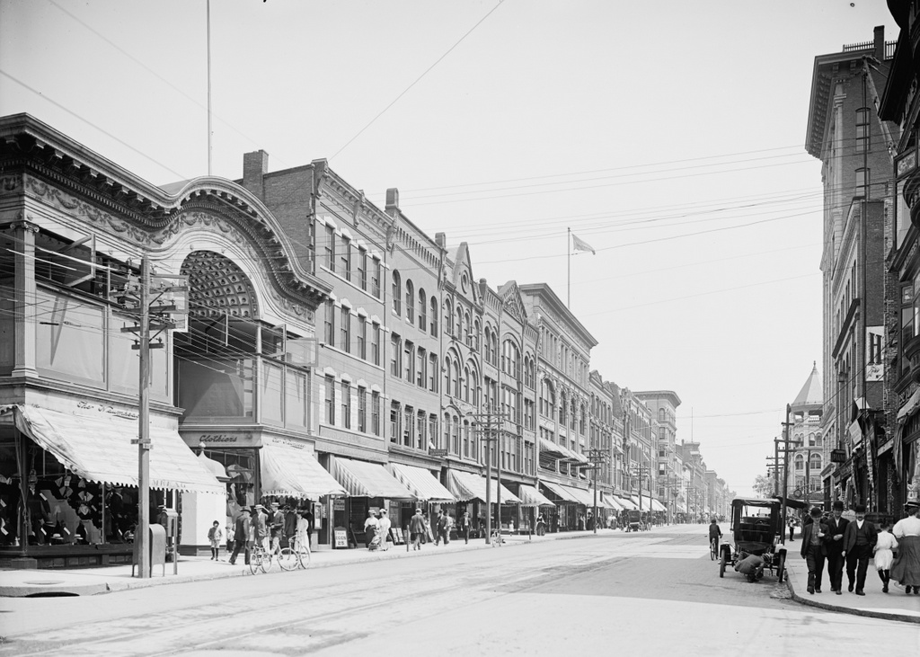
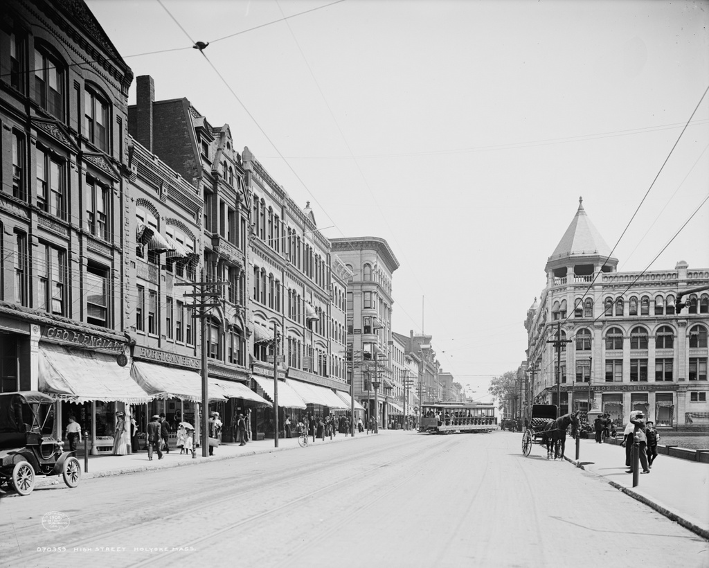
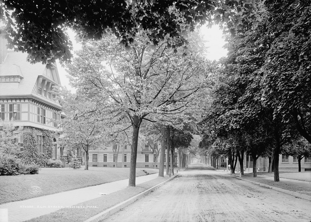
Looking north on Elm Street toward Appleton Street in Holyoke, around 1908:
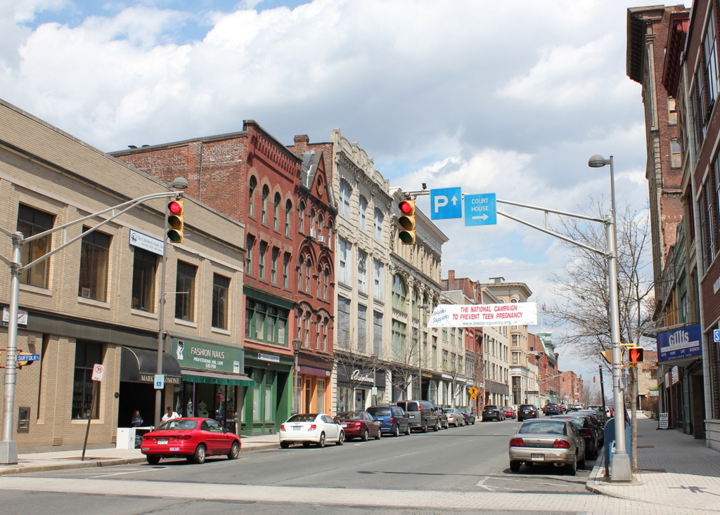
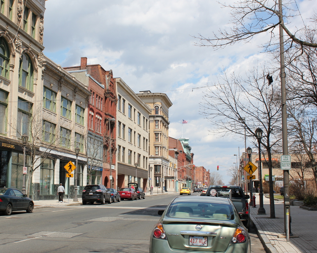
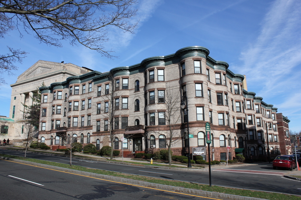
496_1908c loc

Elm Street in 2015:

496_2015

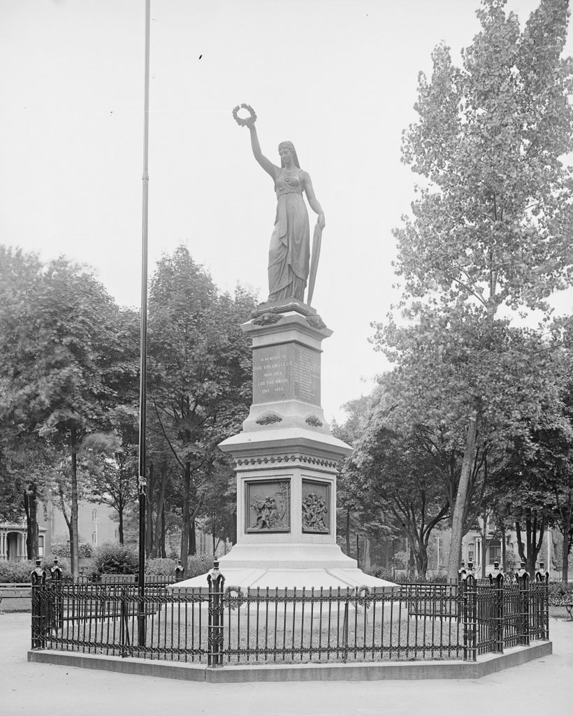
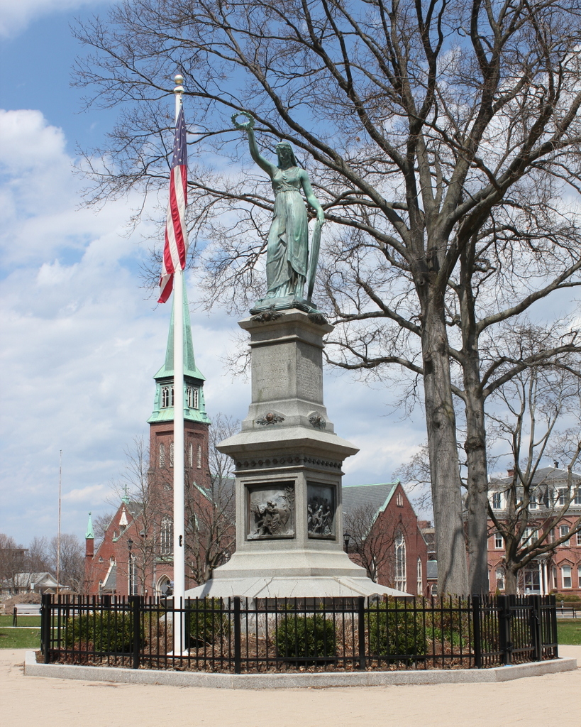
The contrast in these two scenes illustrates what has happened in Holyoke over the past century.  When the first photo was taken, the city was rapidly growing in population; by the 1910 census, it had over 57,000 residents, and the city was one of the world’s leading paper manufacturing centers.  However, by the middle of the 20th century the factories began closing, and the population dropped.  The 2010 census showed fewer than 40,000 residents, and Holyoke currently has the second lowest median household income level out of all 351 Massachusetts cities and towns.  The house and the apartment building on the left-hand side of Elm Street are still there from the 1908 photo, but otherwise it is a very different scene today.

Civil War Monument, Holyoke Mass

The Civil War Monument in Veterans’ Memorial Park in Holyoke, around 1900-1910. Image courtesy of the Library of Congress, Detroit Publishing Company Collection.

495_1900-1910 loc

The statue in 2015:

495_2015

Civil War monuments are a common feature in communities across the country, and Holyoke is no exception with their monument to the city’s 55 residents who died in the war.  What is rather unusual about this one, though, is the sculptor: former Confederate soldier Henry Jackson Ellicott.  It is also unusual in that most Civil War monuments feature the figure of a soldier, while Ellicott’s creation has Liberty holding a wreath atop the monument.  It was dedicated on America’s centennial, July 4, 1876, and today it remains at the center of Veterans Park, which now includes monuments for veterans of World War II, Korea, and Vietnam.

Not much of the surrounding neighborhood is visible in the first photo, but St. Jerome’s Church is clearly visible in the 2015 view.  Although mostly obscured by leaves, the church is there in the first photo; in fact, not only is it older than the monument, but it is older than the war itself.  The church was completed in 1860 to serve the growing population of mill workers, and was the first of many Catholic churches in Holyoke.  The statue includes a list of the 55 Holyoke men killed in the war, and among these are Irish names like Sullivan, McDonald, Cronan, and Donahue, so they very well could have been parishioners across the street at St. Jerome’s Church before they enlisted.

High Street, Holyoke Mass (2)

Looking north on High Street from Suffolk Street in Holyoke, around 1903-1907. Image courtesy of the Library of Congress, Detroit Publishing Company Collection.

493_1910-1910c loc.tif

High Street in 2015:

493_2015

These photos show a scene similar to the ones in this post, just a half a block further south, at the corner of High and Suffolk Streets.  This area is also part of the North High Street Historic District, and all of the buildings on the left-hand side date to between 1880 and 1920.  The first photo was taken at a good time to show some of the changes that happened in the early 19th century.  Had this photo been taken less than 10 years later, we would see almost no change today; all of the present-day buildings in the foreground were built by about 1912.  Starting on the far left side and heading down High Street, the first five buildings in the present-day photo are:

  • An unnamed commercial block, which was built in 1910 and replaced two earlier buildings, including the ornate Naumkeag Clothiers building in the first photo.
  • Bishop Block, which was built around 1890 and has had a few alterations over the years, especially the facade on the second floor.
  • Taber Block, which was built around 1884 and is architecturally very similar to the Russell-Osborne Building further down the street
  • Childs Building, which was built around 1912
  • Steiger’s Building, which was built around 1900 and was home to one of Albert Steiger’s department stores

Overall, the changes in the two photos reflect the prosperity of Holyoke at the turn of the last century; its paper mills were bringing jobs and wealth to the city, and this was seen on High Street, where relatively new buildings from the 1880s and 1890s were being taken down and replaced by larger commercial buildings.  However, just as new construction on this part of High Street seemed to stagnate by the mid 20th century, Holyoke’s economy also stagnated with the closing of the paper mills.  Today,  parts of Holyoke are filled with historic buildings, but sadly this is not necessarily because of careful attention to historic preservation, but rather from a lack of new economic development in the city.

High Street, Holyoke Mass (1)

Looking north on High Street between Suffolk and Dwight Streets, around 1908. Image courtesy of the Library of Congress, Detroit Publishing Company Collection.

492_1908c loc.tif

High Street in 2015:

492_2015

Holyoke has a number of buildings that are listed on the National Register of Historic Places, but these photos show the only Historic District located within the city.  The two photos show a number of changes in the past 100 years, but even the most of the “new” buildings seen in the 2015 photo date to the 1920s or earlier.  Several notable buildings from the first photo have survived, though.  On the left-hand side, starting closest to the foreground, they are:

  • Mayberry Building (narrow red brick building) – Built in 1881, although it had a fourth story added at some point after the 1908 photo.
  • Russell-Osborne Building (the next red brick building) – Built in 1885, this building’s ornate facade contrasts with most of the other more reserved architectural styles, but it has lost some of its decoration over the years, including the gargoyle-like carvings that can be seen in the 1908 photo.
  • Ball Block (yellow brick, in center of the photos) – Built in 1898 and located at the corner of High and Dwight Streets, this was an office building but was later converted into a bank.  However, most of the modifications were made to the interior, so from the outside it hasn’t changed much in appearance since the first photo was taken.
  • Caledonia Building (in the distance, flying an American flag) – Built in 1874, its Second Empire architectural style with a mansard roof is very different from most of the other buildings along this part of High Street, but its exterior hasn’t changed much since it was built.

State & Myrtle Streets, Springfield, Mass

The State Street Methodist Episcopal Church at the corner of State and Myrtle Streets, around 1873-1885. Image courtesy of the New York Public Library.

483_1865-1885c nypl

The same location, around 1905. Photo from Springfield Present and Prospective (1905).

The scene in 2019:

The first photo shows the State Street Methodist Episcopal Church, which was situated opposite the main entrance to the Armory, and likely served many of the workers there.  The church wasn’t here for too long, however, because in 1899 they merged with another congregation, and this property was sold.  The apartment building seen in the last two photos, identified in Springfield Present and Prospective as the Oxford Apartment House, was built on the site and was completed in 1901.  Given its location, it was probably home to many Armory workers, and today the exterior hasn’t really changed at all.  The only major difference between the last two photos is the massive Masonic Temple, which was built in 1923 and can be seen behind the apartment building.


Springfield Armory Entrance, Springfield Mass

The entrance to the Springfield Armory at the corner of State Street and Byers Street, around 1907. Photo courtesy of the Library of Congress, Detroit Publishing Company Collection.

482_1907c loc.tif

The entrance in 2015:

482_2015

This gate at the southwestern corner of the Armory grounds was opened in the 1870s, when the grade of State Street was lowered and the previous main entrance became unusable.  This became the main entrance for many years, but the advent of automobiles and trucks made the narrow gate and fairly steep grade impractical.  So, around 10 years after the first photo was taken, a new main entrance was opened on Federal Street; this continues to function as the main entrance for Springfield Technical Community College, which now uses the Armory grounds.  In the distance of both photos is the Arsenal, which was completed in 1851 and is discussed further in this post.