Railroad Station, East Longmeadow Mass

The railroad station near the center of East Longmeadow in 1910. Photo courtesy of the East Longmeadow Historical Commission.

476_1910-03-14 elonghistcom

The station in 2015:

476_2015

The station in 2023:

Today, East Longmeadow doesn’t have any active rail lines, but a century ago the Armory Branch of the New York, New Haven & Hartford Railroad passed through the town.  The line connected East Hartford and Springfield, and passed by the Watershops of the Springfield Armory, which gave the branch its name.  In East Longmeadow, it provided a way for the many quarries in town to ship their stone, and it also provided a method of transportation in the days before automobiles.  However, the branch was never a major route, and was abandoned by the 1980s.  Today, most of the line is still abandoned, but a 1.6 mile section in East Longmeadow is now the Redstone Rail Trail, named for the quarries that once used the line.  The station, which opened in 1876, is located at the northern terminus of the trail, and although it has clearly seen better days, it is still instantly recognizable from the 1910 photo.

2023 Update: As shown in the third photo, station has since been restored, and it reopened in 2021 as an ice cream shop.

Randolph Beebe House, Wilbraham Mass

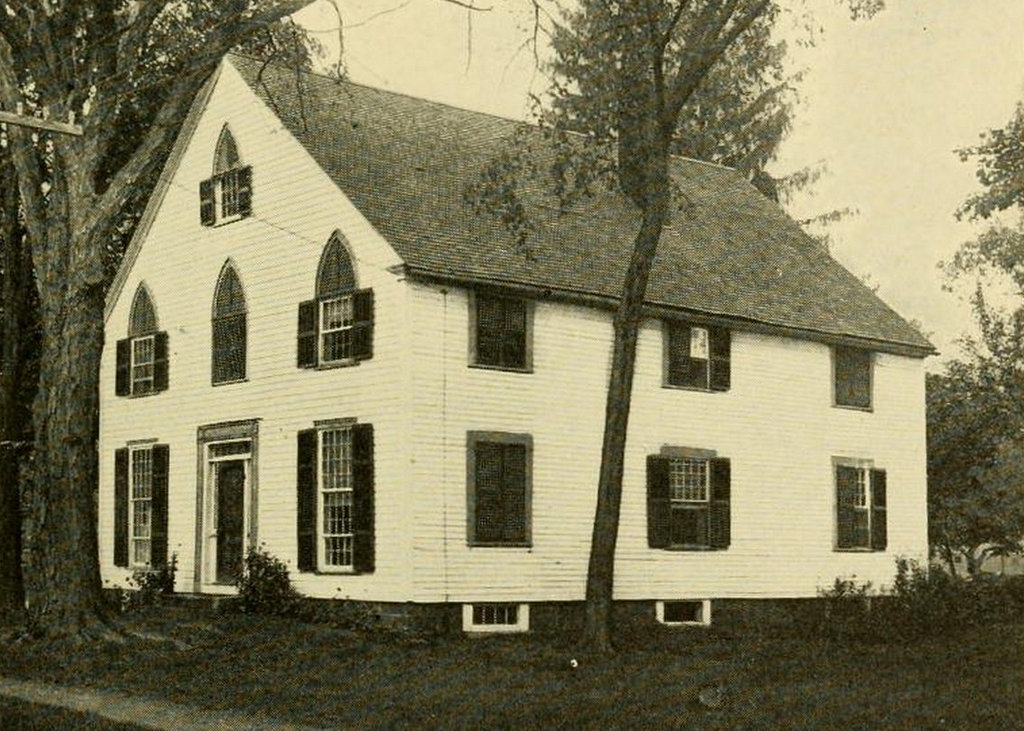
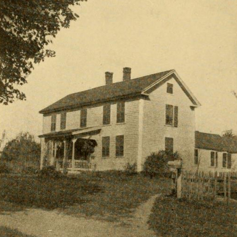
The Randolph Beebe House on Beebe Road in Wilbraham, around 1913. Photo from The History of Wilbraham, Massachusetts (1913).
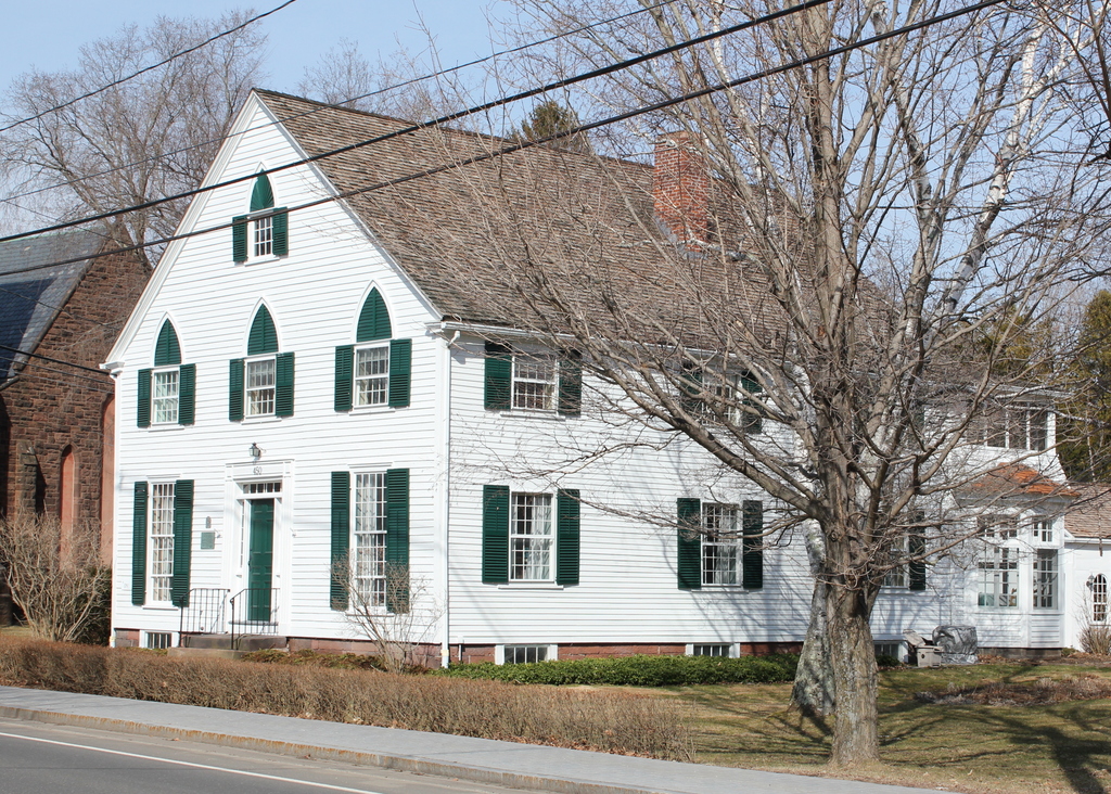
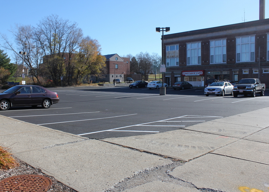
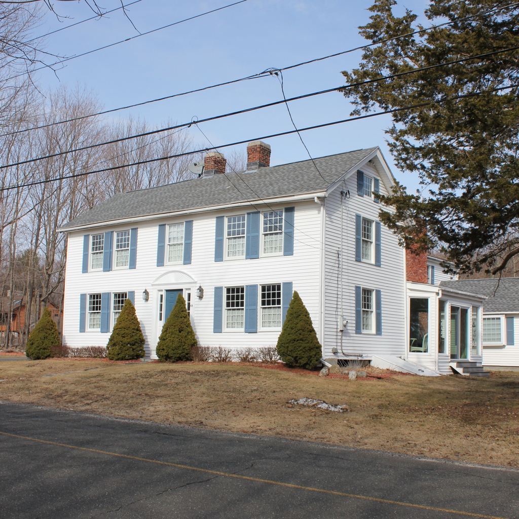
467_1913c peckhistwilb

The house in 2015:

467_2015

This house on Beebe Road in Wilbraham was built around 1785-1790 and was originally occupied by Daniel Chappel, although he didn’t live here for long.  The next family, Nathan and Mary Mack, lived here from around 1790 to 1810, and their daughter earned a place in local folklore in this house.  According to the account given in The History of Wilbraham Massachusetts in 1913, Mary discovered that her young daughter was playing with a rattlesnake in her lap.  She rescued her daughter from the snake and covered it with a tub until Nathan returned home.  He then killed the snake, cut off the rattles, and gave them to his daughter, who kept them in the family for several generations as an odd family heirloom.

By the time the 1913 photo was taken, the house was owned by Randolph Beebe, whose father in law, Thomas Gilligan, had previously owned it since around 1860.  Randolph died in 1923, and the house was apparently vacant for some time, although it was during this time that the house made a rather unexpected contribution to American literature.  In the summer of 1928, horror/science fiction writer H.P. Lovecraft was touring parts of New England, and this included an eight-day stay at the home of Evanore Beebe in Wilbraham, just a short distance from this house, on Monson Road.  Later in 1928, he wrote one of his most famous short stories, “The Dunwich Horror,” which according to Lovecraft himself, “is based on several old New England legends — one of which I heard only last month during my sojourn in Wilbraham.”  One of these legends is about whippoorwill birds being an omen of death, and that they can capture departing souls.  Lovecraft heard this story while he was staying at Evanore Beebe’s house, but it was actually this house, formerly owned by Randolph Beebe, that provided the legend.  According to what Lovecraft wrote in 1934, “I saw the ruinous, deserted old Randolph Beebe house where the whippoorwills cluster abnormally,” and from that he learned about the legend that provided part of the basis of his famous short story.

I don’t know how long the house was vacant after Lovecraft’s visit, but it was occupied again by the 1950s.  In the century since the first photo was taken, the house has substantially increased in size with several additions in the back, but the original 1780s part of the house still retains its appearance from over 200 years ago.

Glendale Road, Wilbraham Mass

Looking north on Glendale Road in Wilbraham, toward the intersection of Monson Road, around 1914. Photo courtesy of the Wilbraham Public Library.

466_1914c wpl

Glendale Road in 2015:

466_2015

Topographically speaking, the town of Wilbraham is divided into two major sections: the western half of the town is part of the Connecticut River valley, and is mostly flat.  This was the area that was first settled in Wilbraham, as it provided decent farmland and a close proximity to Springfield.  However, the eastern part of the town is very different.  Just east of Main Street, the terrain abruptly rises, with a ridgeline over 500 feet above the center of town.  The land on the other side of this ridge is very different; it tends to be steeper, more rocky, and less arable than the valley, so this area was slow to develop.

It is this eastern section of town that is seen in these two views, an area known as Glendale.  When the 1914 photo was taken, it had a church, a cemetery, a school (out of view beyond the church), and a few farmhouses.  It was never really a village, just a crossroads.  The first photo was taken at a time when automobiles were beginning to become more common, but it’s unlikely that too many would’ve ventured out into this area, given the condition of the roads.  The ruts in the foreground indicate that the road probably got fairly muddy, and based on looking at the slope, it appears that this section of road would probably get washed out fairly easily in a rainstorm.

The only building in this scene is the Glendale Methodist Church, which was built in 1868 to serve the farmers in the eastern part of town, who would’ve otherwise had to venture up and down steep grades to reach the Methodist church in the town center.  Across Glendale Road from the church, on the left-hand side of the photo, is Glendale Cemetery, which is actually substantially older than the church itself; the earliest gravestone dates to 1787.  Today, the church building is still there, barely visible beyond the trees, but the congregation itself disbanded in 2006, and the building has been vacant ever since.  Glendale and Monson Roads are still there, although the grade of the intersection has been raised substantially by filling in some of the swampy area along the stream that passes under the roads.

Old Methodist Meeting House, Wilbraham Mass

The Old Methodist Meeting House at the corner of Main Street and Mountain Road in Wilbraham, probably around 1913. Photo from The History of Wilbraham, Massachusetts (1913).

464_1913c peckhistorywilb

The building in 2015:

464_2015

The old Methodist meeting house in Wilbraham hasn’t been used as a church for over 180 years, but some of its defining architectural features are still visible, including the long windows on the Main Street side of first floor.  It was built in 1793, as the first home of Wilbraham’s Methodist congregation.  It was used for 40 years, before being sold and renovated into a house.  As built, the church only had one floor, with windows that extended all the way up the side of the building.  When it was converted to a house, the second floor was added, and the windows were split, although the pattern is still noticeable here.

At the time that the church was built, Methodism was still in its infancy in New England.  Several important figures in Methodist history visited this church in the late 1700s and early 1800s, including Francis Asbury, who was one of the first bishops appointed by founder John Wesley, and Jesse Lee, who later became Chaplain of the US House of Representatives from 1809 to 1814, and Chaplain of the US Senate from 1814-1815.  During the first years of this church, the interior was rather spartan; the pews were just wooden benches, and a stove was not installed until 1815, after some 22 cold New England winters without any heat.  Something as novel as an organ would take even longer; the congregation didn’t purchase one until 1850, long after they had moved to a newer church building.

The Methodists built a new church across Mountain Road in 1833, and this was in turn replaced in 1870 by the stone church visible behind and to the left of the church in this photo.  Today, the building is one of the oldest existing church buildings in Western Massachusetts, and according to the 1963 History of Wilbraham book, it is the oldest existing Methodist church in New England.  Today, it is maintained as a museum by the Wilbraham Atheneum Society.

Soldiers’ Monument, Wilbraham Mass

The Soldiers’ Monument in Wilbraham, on Main Street opposite Springfield Street, in an undated photograph probably taken in the early 20th century.  Photo courtesy of the Wilbraham Public Library.

463 1900sc wpl

The monument in 2015:

463_2015

As mentioned in this post, the Soldiers’ Monument in Wilbraham was dedicated in 1894, in honor of the 228 men from Wilbraham who served in the Civil War.  According to the inscription on the monument, it is dedicated “To the men of Wilbraham who served their country in the war which preserved the Union and destroyed slavery.  This monument is erected to perpetuate the memory of their patriotic service.”  According to the records in the town clerk’s office, 29 Wilbraham men died in the war.  However, of those 29, only six were killed on the battlefield, a statistic that is not at all unusual for the Civil War, given that around two thirds of all deaths were a result of disease rather than battle.  One particularly notable Wilbraham veteran was Watson W. Bridge, who was the captain of Company F in the 54th Massachusetts Infantry Regiment, an African-American unit that was depicted in the 1989 film Glory.

The monument was built on the site of the birthplace of Lucinda Brewer, the wife of paper manufacturer Zenas Crane, founder of Crane & Co. in Dalton, Massachusetts.  Their grandson, Winthrop M. Crane, attended the dedication ceremony in 1894.  Several decades earlier, he had secured a contract to produce the paper for US currency, something that the company continues to do today.  He would later go on to serve as Governor from 1900 to 1903, and represented Massachusetts in the US Senate from 1904 to 1913.

In the years since the first photo was taken, the land behind the monument has been developed, as seen in the 2015 view.  To the left is the former Wilbraham Post Office building, and directly behind the monument is the Wilbraham Public Library.  To the right, just outside of the view of the photo, is a commercial development.

Hanging Around the Saloon, Chicopee Mass

A group of workers hanging around outside of the Cyran & Gierlasinski Cafe on Grove Street in Chicopee, on June 29, 1916. Photo courtesy of Library of Congress.

448_1916-06-29 loc.tif

The scene in 2014:

448_2014

Social reformer and photographer Lewis Wickes Hine visited Chicopee several times in the 1910s, documenting child labor conditions in some of the city’s factories.  The first photo here shows a group of workers hanging around a saloon at the end of the workday.  It’s probably safe to assume that the cafe was Polish; the names of Cyran & Gierlasinski leave little room for doubt.  By the late 1800s, Chicopee had become an industrial center, and many of the workers were immigrants, either French-Canadian or Polish.  To this day, many Chicopee residents are of French-Canadian and Polish ancestry, some of whom are probably the descendants of the men in the 1916 photo.  Today, the Cyran & Gierlasinski Cafe might be gone, but the Polish influence is still present; the site is now the parking lot for the main offices of the Polish National Credit Union.