Fire Department Headquarters, Springfield, Mass

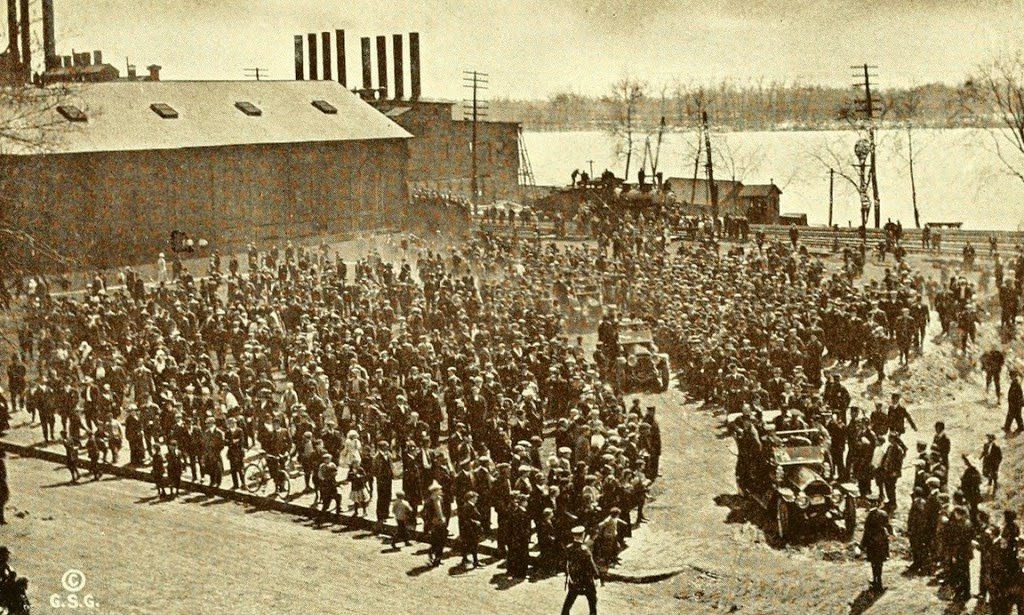
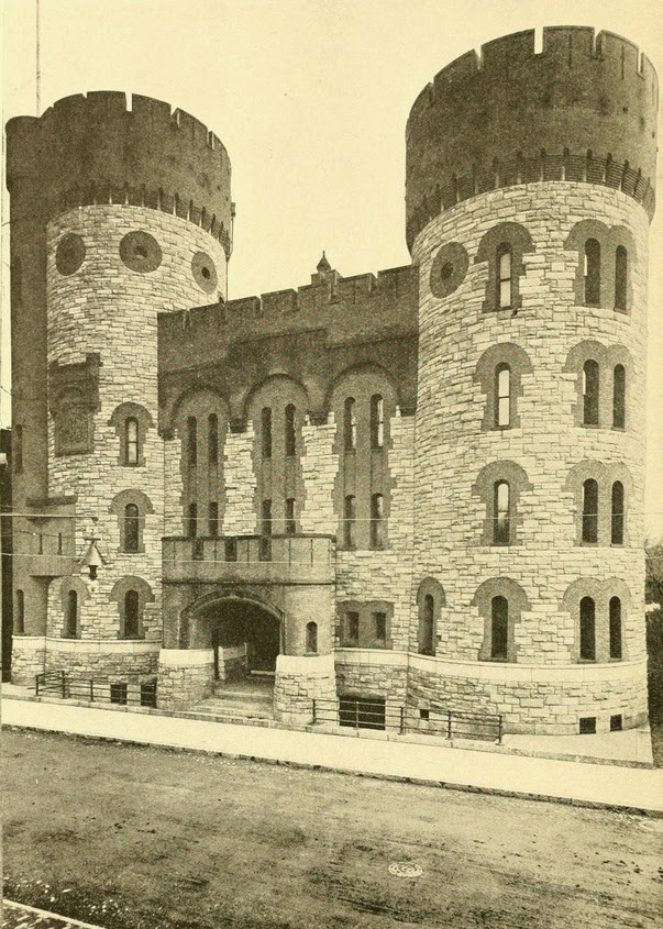
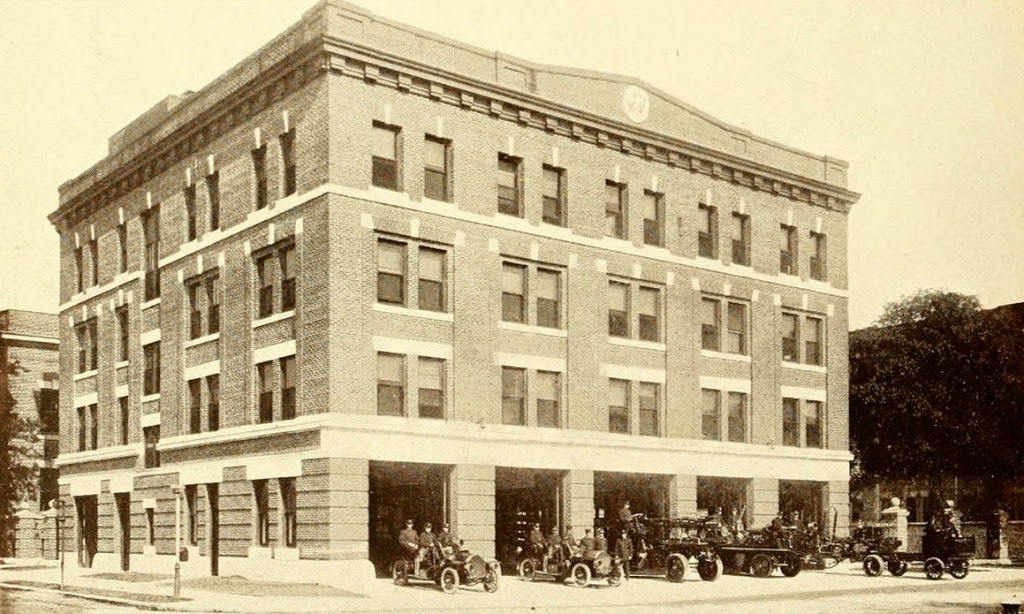
Springfield Fire Department Headquarters on Court Street, around 1900-1913. Photo from Progressive Springfield, Massachusetts (1913).

400_1910-1913c-2Bprogressivespfld

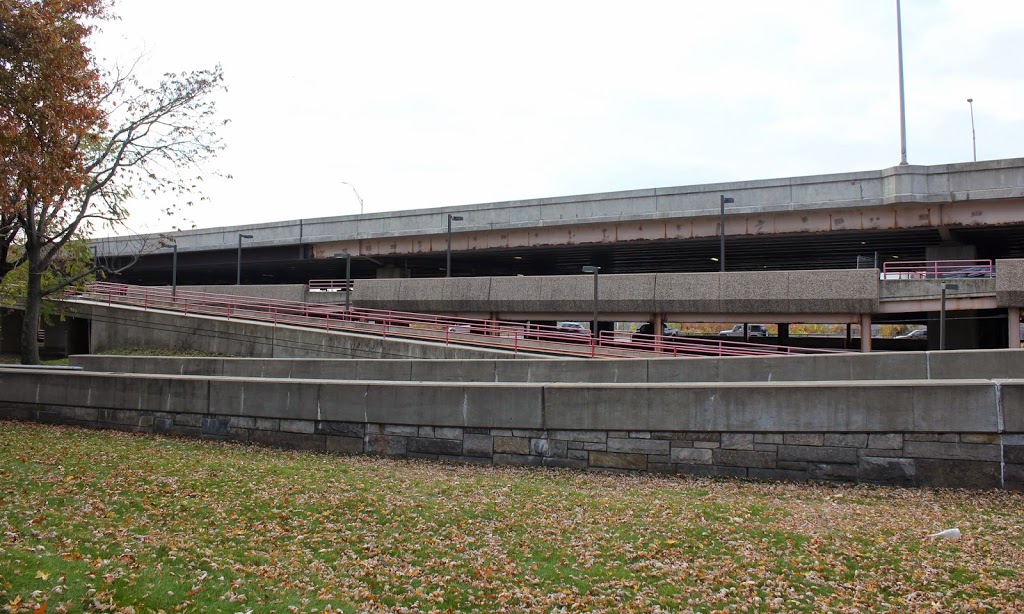
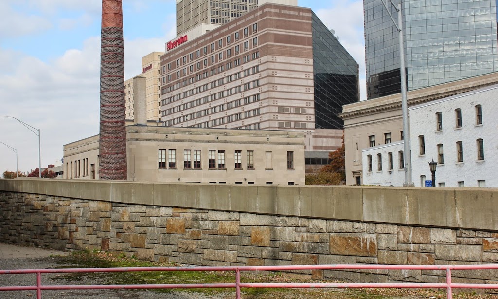
The scene just over 100 years later, in 2014:

400_2014

This fire station was built on about the same spot that Parsons Tavern used to occupy for most of the 1800s.  It must have been completed shortly before the first photo was taken, because the caption in Progressive Springfield, Massachusetts describes it as the “new” headquarters, and describes how:

“No city has a more up-to-date fire department and headquarters station than Springfield. The new station on Court Street cost $110,000. Its apparatus is all motor-driven and has modern conveniences for the force. The top floor houses the new fire alarm system installed at an expense of $30,000.  The flying squadron shown above consists of autos for Chief and Assistant Chief, the Electric Aerial Ladder Truck, Combination Electric Wagon and Hose and Water Tower with Gasoline Tractor.  The city expends about $240,000 a year on this department.”

Today, the location of this fire station is now an on-ramp for Interstate 91; the 2014 photo was taken from the parking garage directly underneath the highway.  The city’s two tallest buildings, Monarch Place and Tower Square, can both be seen in the photo, along with Symphony Hall, on the right-hand side.  It’s probably the only building visible that existed when the first photo was taken.  The Springfield Fire Department now has its headquarters on Worthington Street, although I don’t know that they still have any “Combination Electric Wagons” on the force.

President Taft at Springfield, Mass (2)

Another scene of William Howard Taft at Court Square in Springfield on April 25, 1912. Photo from Progressive Springfield, Massachusetts (1913).

399_1912-2Bprogressivespfld

The scene in 2014:

399_2014

These were taken from the same spot as the photos in this post, just facing toward the Connecticut River instead of toward Old First Church.  The 1912 photo shows President Taft arriving in Springfield, with a crowd of onlookers waiting for him.  The photo also shows the extension of Court Square, which once went all the way down to the Connecticut River.  Today, Interstate 91 passes across here, with a parking garage underneath.

President Taft at Springfield, Mass (1)

President William Howard Taft, giving a speech on Court Square in Springfield, on April 25, 1912. Photo from Progressive Springfield, Massachusetts (1913).

398_1912-2Bprogressivespfld

The scene in 2014:

398_2014

The 1912 photo was taken on the same day as the photo in this post, which shows a close-up of President Taft speaking on the platform.  Here, the platform can be seen behind Old First Church on the left-hand side, and it shows the massive crowd that had assembled to see him during his 1912 presidential campaign, which would end with him earning the Republican nomination but losing to Woodrow Wilson in the November election.  Today, three of the buildings from the first photo are still there: Old First Church, the Court Square Hotel, and the old Hampden County Courthouse.  There are also some remnants of this part of Court Square, which once stretched from the back of Old First Church to the Connecticut River (which can be seen in this post).  Today, the Hampden County Hall of Justice covers part of the land, and East Columbus Avenue passes diagonally across it.

State Street, Springfield, Mass

State Street in Springfield, around 1910-1913. Photo from Progressive Springfield, Massachusetts (1913).

397_1910-1913c-2Bprogressivespfld

State Street in 2014:

397_2014

The scene in 2023:

It will be interesting to do another “now” photo in a couple years, because this scene will be changing soon. Taken looking east on State Street from in front of the Hampden County Hall of Justice, this scene shows several buildings that will be demolished or substantially altered when the casino is built. The building on the right-hand side of the 2014 photo is the United Electric Company building, which had just been built shortly before the first photo was taken, and will be (mostly) demolished in the near future, with the casino retaining only the façade. A few other buildings along State Street will also either be demolished or have just he façade saved.

Other buildings in the photos include the Court Square Hotel, which extends across the block from Elm Street to State Street, and the Nayasset Club building, on the far right of the first photo.  The Nayasset Club was a social organization that at the time included many of Springfield’s prominent citizens.  The building is now gone, and in its place is a parking lot across from the old Hampden County Courthouse, which is barely visible on the left-hand side of the 2014 photo.

2023 update: As promised when I wrote the post back in 2015, I have updated the post to include a third photo, which shows the same scene following the completion of the MGM casino on the right side of the street.

State Armory, Springfield, Mass

The Armory on Howard Street in Springfield, around 1910. Photo from View Book of Springfield (1910).

395_1910c-2Bviewbookofspringfield

The building in 2014:

395_2014

The State Armory in Springfield (not to be confused with the much larger, more prominent federal Springfield Armory) was built in 1895 for the Massachusetts Militia, and later the Massachusetts National Guard.  The building included both the castle-like structure facing Howard Street, as well as a massive drill shed that extended the width of the block to Union Street.  After the National Guard left, it became the South End Community Center, but it sustained significant damage from the June 1, 2011 tornado, which completely destroyed the former drill shed.  Like the former YWCA Building, the old Armory is right in the middle of the planned casino development, and the current plan is to demolish all but the facade, which will be incorporated into the casino.

YWCA Building, Springfield, Mass

The YWCA building on Howard Street in Springfield, around 1910. Photo from View Book of Springfield (1910).

394_1910c-2Bviewbookofspringfield

The building in 2014:

394_2014

The scene in 2023:

The building’s appearance hasn’t changed much over the past century, but its use has.  It was built in 1907 as a residential building for the YWCA, after the organization moved from its old location a block away on Bliss Street.  It continued to be used by the YWCA until at least the 1980s, but today it is the Western Massachusetts Correctional Alcohol Center, a minimum security facility for alcohol-related offenders.  However, it probably won’t be for long – Howard Street is right in the middle of the planned casino development, so the days appear to be numbered for the historic building.

2023 update: The building was demolished soon after the second photo was taken, and the site is now part of the MGM Springfield casino. A replica of the building façade was incorporated into the casino design, although not in its original orientation, as shown in the third photo.