Commonwealth Avenue, Boston

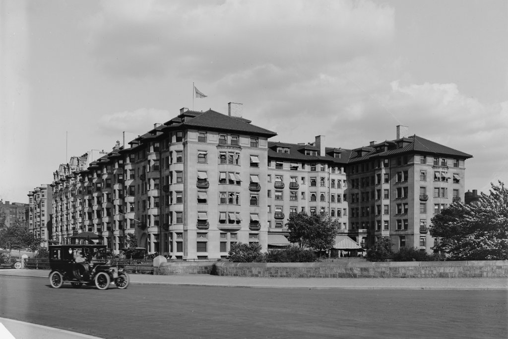
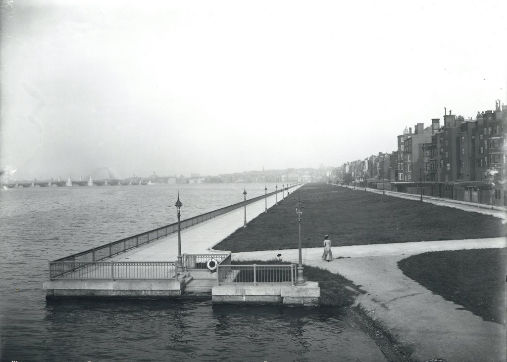
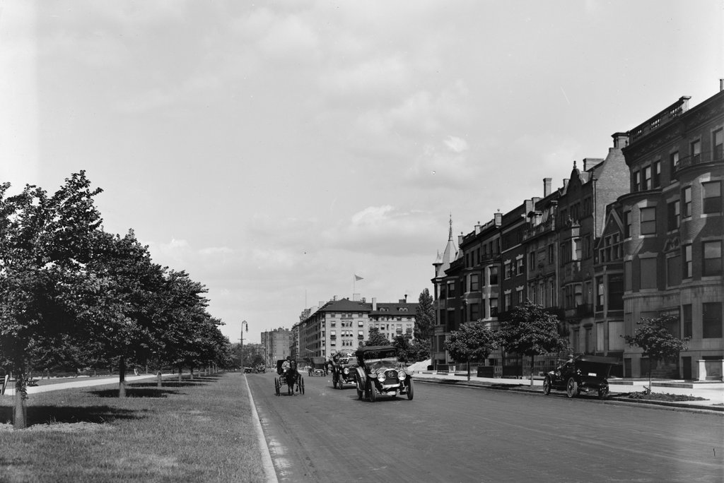
Looking east on Commonwealth Avenue from near Kenmore Square, around 1910-1914. Image courtesy of the Library of Congress, Detroit Publishing Company Collection.

707_1910-1920c loc

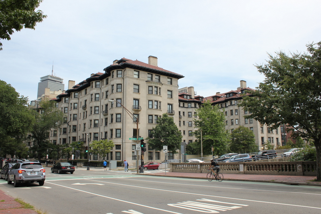
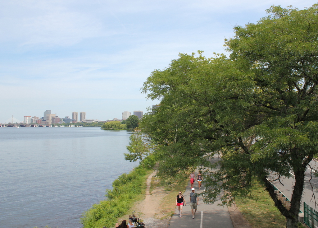
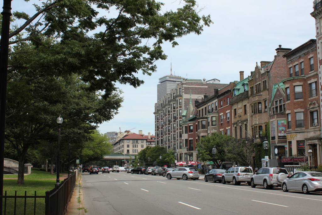
Commonwealth Avenue in 2015:

707_2015
When the first photo was taken, the Kenmore section of Boston was still being developed. The apartment building on the right, which is missing in the first photo, was built in 1916, and the other houses in the photo aren’t much older.  These late Victorian-era homes were built in the late 1890s, around the same time as the Hotel Somerset, which can be seen in the distance in the lower center of the photos.  To the left is the median of Commonwealth Avenue, which was part of the original design of the Back Bay to have a wide avenue with a large, landscaped central median.  Although today Commonwealth Avenue has one way traffic on each side of the median, this apparently wasn’t the case in the early 1900s; the first photo shows traffic traveling in both directions on what is now the eastbound side of the road.

Around 100 years later, most of the buildings from the first photo are still standing today.  The houses to the right now have stores on the ground floors, but despite this there haven’t been any drastic alterations.  As mentioned in the previous post, the Hotel Somerset is still standing on the other side of the elevated Charlesgate, but it was converted into condominiums in the 1980s.  To the left in the median, part of the old subway portal is visible in the 2015 photo.  This section of the subway opened in 1914, probably not long after the first photo was taken, with the trolleys coming to the surface at this spot in the median before crossing Kenmore Square.  This portal has since been closed off, but the arch at the top is still above ground.

Hotel Somerset, Boston

The Hotel Somerset at the corner of Commonwealth Avenue and Charlesgate East in Boston, around 1910-1920. Image courtesy of the Library of Congress, Detroit Publishing Company Collection.

706_1910-1920c loc

The building in 2015:

706_2015
When this historic building was completed in 1897, it was at the very edge of the city.  There were parts of Boston further west of here, such as today’s Fenway/Kenmore neighborhood, but at that point there was very little development going on.  Even the 1898 city atlas didn’t cover further west of here, and it shows that many of the building lots around the hotel were still vacant.

Although the Hotel Somerset was initially surrounded by vacant lots, the city soon grew up around it, as the first photo shows. It was a prominent city hotel, with notable guests such as The Beatles, who stayed here during their visit to Boston in 1966, as well as visiting baseball teams, since Fenway Park is just a quarter mile away.  Ted Williams also stayed here during the baseball season, renting Room 231 for many years.

In the century since the first photo was taken, many of the surroundings have changed.  The Massachusetts Turnpike passes within 50 feet of the building on the other side, and on this side an elevated roadway crosses Commonwealth Avenue, with an off-ramp on the right side of the photo in front of the building.  The hotel itself was converted to condominiums in the 1980s, but from the outside it still doesn’t look much different from the first photo.

Back Street, Boston (2)

Looking east on Back Street in Boston from Hereford Street, probably in 1907. Image courtesy of the City of Boston Archives.

705_1880-1915c coba

Back Street in 2015:

705_2015
These photos show the scene only a block further down Back Street from the ones in this post, and the old photo here was probably taken on the same day as the other one.  As mentioned in the other post, Back Street is a narrow alley that is used to access the rear of the houses along the north side of Beacon Street.  When the first photo was taken, Back Street was the very northern end of the Back Bay, with only a flimsy-looking wooden guardrail separating the street from the Charles River.

Over time, this has changed, with the first change coming soon after the photo was taken.  In 1910, the Charles River Esplanade was completed along the Charles River, creating a long, narrow strip of public parkland between Back Street and the Charles River.  However, later in the 20th century much of the original park was taken to build Storrow Drive, a parkway connecting downtown Boston to the western parts of the city.  It isn’t visible because of the dumpster in the foreground, but Storrow Drive runs right next to the street, with only a low chain link fence separating the two.  On the other side of Storrow Drive, the Esplanade has been expanded, and can be accessed from Back Street via several pedestrian bridges.

Charles River Esplanade, Boston

Looking east along the Charles River Esplanade from the Harvard Bridge on Massachusetts Avenue, on October 5, 1910. Image courtesy of the City of Boston Archives.

704_1910-10-05 coba

The view in 2015:

704_2015
These photos were taken just a short distance along the bridge from the ones in the previous post, and the first photo here shows the Charles River Esplanade as it appeared soon after its completion.  This parkland was built on reclaimed land just north of Back Street, which was once located right along the Charles River, as seen in the 1907 photo of the previous post.  The Esplanade underwent a major change in the early 1950s, though, when Storrow Drive was built through here.  This parkway allows relatively easy access to downtown Boston from points west, but in the process it largely cut off the Esplanade from the rest of the Back Bay.

Today, the park is still there, and although it is noticeably smaller from its appearance the first photo, it was expanded in other areas to compensate for the land taken to build Storrow Drive.  Part of the expanded parkland can be seen in the distance, just to the left of the center.  The only significant landmark that is clearly visible in both photos is the Longfellow Bridge, which can be seen in the distance to the left.  It was completed in 1906, and still carries vehicles and Red Line subway cars over the Charles River between Boston and Cambridge.

Back Street, Boston

Looking east along Back Street in Boston from Massachusetts Avenue, on October 14, 1907. Image courtesy of the City of Boston Archives.

703_1907-10-14 coba

Back Street in 2015:

703_2015
When the Back Bay was filled and developed into a residential neighborhood in the late 1800s, the houses on the north side of Beacon Street were only a few feet away from the Charles River, separated only by the narrow Back Street, which serves as an alley to access the back of the houses.  Within a few years after the first photo was taken, though, this area began to change.  In 1910, the Charles River Esplanade was completed as a public park along the banks of the Charles River, and the first photo was probably taken as part of the city’s preliminary work on the project.

By the late 1940s, traffic congestion in Boston required some of the land to be used to build a parkway, so in 1951 Storrow Drive was completed as a six lane, automobile-only road with low clearances and no shoulders.  Most of the original parkland was lost, so more land was reclaimed from the Charles River on the other side of Storrow Drive.  As a result, this section of Back Street is now over 250 feet from the Charles River, which isn’t even visible from the ground level anymore.  Many of the 19th century rowhouses are still standing here, but the view from the north-facing windows has been drastically changed now that they have a highway in their backyards.

Boston & Albany Rail Yard, Boston

The Boston & Albany yard along Boylston Street in Boston’s Back Bay, on October 4, 1912. Image courtesy of the City of Boston Archives.

702_1912-10-04

The view in 2015:

702_2015
The Boston & Albany Railroad maintained a rail yard on this site in the Back Bay for many years, but as the city continued to grow around it in the 20th century, it began to be eyed for potential redevelopment.  The yard took up most of the triangular-shaped area between Boylston Street, Huntington Avenue, and Dalton Street, which included the entire south side of Boylston Street west of Exeter Street, as seen in the 1912 photo.  The first photo shows some familiar landmarks on the left, including the firehouse on the far left, the Tennis and Racquet Club, and in the distance the tower of the New Old South Church.  All three are still standing today, but the view to the right has changed significantly.

By the early 1960s, there were several different options for redeveloping the rail yard.  In 1957, the Massachusetts Turnpike had been completed from the New York border to Route 128 in Weston, just outside Boston.  From there, however, it was uncertain which route the highway would take into the city. One option was to build it parallel to the right-of-way of the Boston & Albany Railroad, which would have included passing through this yard.

One of the problems with running the highway through here, though, came when the Prudential Life Insurance Company purchased the yard, with the intent of building a large complex that would include the tallest skyscraper in the city.  Such a plan would be a great economic benefit to the city, but it threatened the highway that would also serve the economic interests of the city.

In the end, both proposals went through, and the Massachusetts Turnpike was completed through here in 1965, a year after the Prudential Tower was completed directly above it.  Today, as seen in the 2015 photo, the highway runs parallel to the railroad, and they both pass under the Prudential complex and the Hynes Convention Center, which can be seen in the foreground. In the distance to the right is the lower part of the Prudential Tower, which 51 years after its construction is still the second-tallest building in the city.