Commonwealth Avenue, Boston (2)

The view along the south side of Commonwealth Avenue, looking west from the Boston Public Garden, sometime in the 1870s. Image courtesy of the Boston Public Library.

805_1870-1879c bpl

The view in 2015:

805_2015
These photos were taken from the same spot as the ones in the previous post, probably even on the same day. As with the other post, the 2015 view here is mostly obscured by the trees on the Commonwealth Avenue Mall, but beyond the trees many of the historic Victorian brownstones are still standing. Because the Back Bay project began here at Arlington Street and worked its way west, the houses at this end of Commonwealth Avenue are among the oldest in the neighborhood, dating mostly to the early to mid 1860s. The houses in the foreground have since been replaced with a high-rise building, but otherwise almost all of the ones between here and Berkeley Street are still standing, and today they make up part of the Back Bay Historic District on the National Register of Historic Places.

Commonwealth Avenue, Boston (1)

Looking west along the north side of Commonwealth Avenue from the Boston Public Garden, sometime in the 1870s. Image courtesy of the Boston Public Library.

804_1870-1879c bpl

The scene in 2015:

804_2015
From the start, the Back Bay was designed to be an upscale residential neighborhood, and these houses on the north side of Commonwealth Avenue typically commanded the highest prices. Here, the residents enjoyed the view of the broad Commonwealth Avenue Mall, and their southern-facing front windows gave them plenty of light. The work of filling the land and building homes began here at Arlington Street in the early 1860s, and as the years went on the development moved westward. By the early 1870s, Commonwealth Avenue reached as far as Exeter Street, four blocks from here. Most of the houses in the foreground of the first photo were built in the early to mid 1860s, when the block between Arlington and Berkeley Streets was developed. They represent the typical residential design for the Back Bay, with 3 to 4 story Victorian brownstones lining the streets that had to conform to strict building codes at the time.

Nearly 150 years after the first photo was taken, the strict building codes have paid off. The neighborhood retains its original 19th century residential appearance, and many of the houses from the first photo are still standing today. The trees, which were just saplings in the 1870s, now hide the view of most of the houses from here, but a few of the buildings are visible to the right, and are easily recognizable from the first photo.There have been some newer houses, like the light-colored one just to the right of the lamppost, but these have generally been in keeping with the original appearance of the neighborhood.

Hotel Vendome, Boston

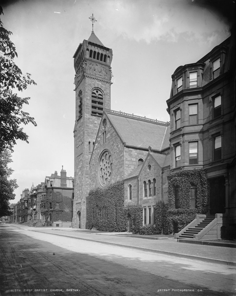
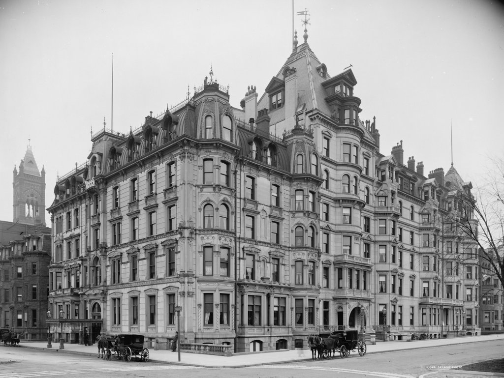
The Hotel Vendome, at the corner of Dartmouth Street and Commonwealth Avenue in Boston, around 1904. Image courtesy of the Library of Congress, Detroit Publishing Company Collection.

782_1904c loc

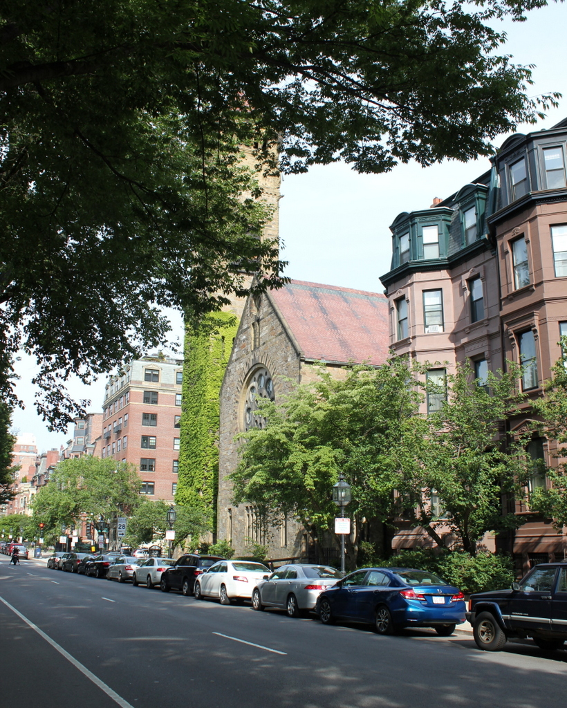
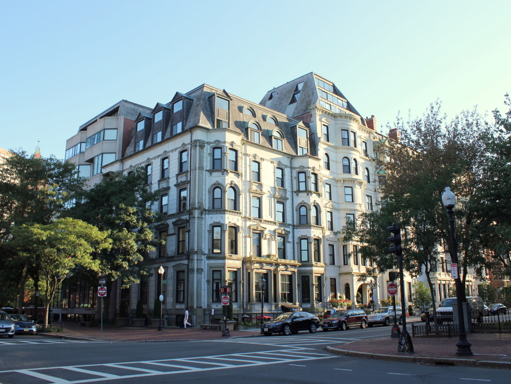
The building in 2015:

782_2015
The Hotel Vendome was part of the original development of the Back Bay, a tidal marsh that was filled in over the course of about 30 years in the 1800s. By the start of the 1870s, the landfill project had reached Dartmouth Street, and the Hotel Vendome was built here along Commonwealth Avenue. The building was much smaller at the time, consisting of just the five-story section at the corner. It was designed by architect William G. Preston, and it has many characteristics of the Second Empire style that was popular at the time. Like many of the city’s 19th century hotels, it functioned more as an apartment building, catering mainly to long-term residents rather than visitors, and it included five rowhouses further to the right, down Commonwealth Avenue, which offered additional options for residents.

The building was sold in 1879, and in 1881 it was substantially expanded with an addition along Commonwealth Avenue where the rowhouses used to be. Architecturally, the addition was similar but not identical to the original building, and it was one story taller, giving the building an asymmetrical appearance from the Commonwealth Avenue side. Following this, there were few significant changes to the building, except for the addition of a penthouse on top of the original section.

Four small fires damaged the building in the 1960s, but the Hotel Vendome is probably best known for the tragic June 17, 1972 fire, which started while the building was mostly vacant and undergoing renovations. The fire was successfully brought under control, but then the southeast corner (far left in the photos) suddenly collapsed, killing nine firemen in what remains the deadliest firefighting accident in Boston Fire Department history.

Following the fire, the renovations were eventually completed, and the collapsed section of the building was rebuilt. The former hotel is now a mix of condominiums, offices, and stores, and although it has seen drastic changes from fire and renovations, especially on the upper floors, it is still recognizable from the first photo over 110 years ago.

First Baptist Church, Boston

The First Baptist Church in Boston, at the corner of Commonwealth Avenue and Clarendon Street in the Back Bay, as seen around 1890-1901. Image courtesy of the Library of Congress, Detroit Publishing Company Collection.

717_1890-1901c loc

The church in 2015:

717_2015
The First Baptist Church was one of many prominent Boston churches that relocated to the Back Bay in the late 1800s, although this building wasn’t originally built for them.  It was designed by Henry Hobson Richardson, whose later works would include Trinity Church a few blocks away at Copley Square.  The top of the tower features carvings by French sculptor Frédéric Auguste Bartholdi, who also designed the Statue of Liberty.  The building was completed in 1875 for Brattle Street Church, a Unitarian church that had previously been located where City Hall is today.  However, the church didn’t last long here; they disbanded in 1876 and sold their new building to the First Baptist Church in 1882.  They are one of the oldest Baptist congregations in the country, dating back to 1665, and they are still located here on Commonwealth Avenue over 130 years later.

Blandford Street Incline, Boston

Facing east on Commonwealth Avenue toward Kenmore Square, with the Blandford Street Incline in the foreground, on January 3, 1933. Image courtesy of the City of Boston Archives.

710_1933-01-05 coba

The same location in 1943. Image courtesy of the City of Boston Archives.

710_1943 coba

The view in 2015:

710_2015
As mentioned in this post, trolley cars once entered and exited the subway from an incline in the median of Commonwealth Avenue just east of Kenmore Square.  However, in 1932 the tunnel was extended a little to the west, with one branch emerging here, at the present-day Boston University campus.  The first photo shows the incline shortly after it opened, and not much had changed ten years later when the second one was taken.

The most obvious change in the first two photos is the signs – by 1943 Kenmore Square had become home to many large advertisements, including ones for Dawson’s Pale Ale and Lager, Socony, the Hotel Kenmore, and Gulf.  Several of these signs were easily visible from Fenway Park, with the Gulf sign in particular being prominent in photographs of the park from that era.  Another sign in the foreground indicates that Park Street is a mere nine minutes away, which either suggests that the trolleys ran much faster than they do now, or that the Boston Elevated Railway was being a little generous in their estimates.

The second photo also reveals a largely forgotten piece of Boston history; the trolley coming up from the tunnel has “National League Park” as its destination.  Long before the Red Sox, the Boston Braves were the city’s original Major League Baseball team, and from 1915 to 1952, they played about a mile up Commonwealth Avenue from here.  After the team moved to Milwaukee for the 1953 season, the old stadium was purchased by Boston University and converted into Nickerson Field, with some of the original structure still standing today.

In the 2015 scene, the subway incline hasn’t changed much; even the poles supporting the overhead wires appear to be the same ones from the first two photos.  To the left, the Boston University campus has continued to expand, and today several of BU’s buildings are visible here.  In the distance, many of the buildings in Kenmore Square are still standing, and although none of the 1940s signs still exist, Kenmore Square is now home to arguably the city’s most famous sign, which appears to be located at the same spot as the old Socony sign.  This Citgo sign is visible over the Green Monster at Fenway Park, and has been identified with the Boston Red Sox ever since it was first constructed in 1965.

Kenmore Square, Boston

Facing east in Kenmore Square, with Beacon Street to the left and Commonwealth Avenue to the right, on November 14, 1911.  Image courtesy of the City of Boston Archives.

709_1911-11-14 coba

Kenmore Square in 2015:

709_2015
The area that makes up Kenmore Square today was originally Sewall’s Point, on the edge of a large tidal marsh along the Charles River.  These photos were taken right about where the shoreline once was when European settlers first arrived in 1630, and there was no dry land from here until Boston Common, around a mile and a half away. This “back bay” of Boston remained relatively unchanged for nearly 200 years, and the site of Kenmore Square, which technically wasn’t even part of Boston at the time, remained undeveloped.

Things started to change in 1821, when the Mill Dam was built across the Back Bay from here to Boston Common.  The idea was to use the tide to power factories in the area, and although that aspect of it was a failure, the dam was also used as a toll road.  Later in the 19th century, when the Back Bay was filled in, the road on the old dam became Beacon Street.  The original dam was never actually dismantled, so the wooden structure is still buried under the road today.

Once the landfill projects were completed around 1900, this area became the intersection of three major roads: Beacon Street, Commonwealth Avenue, and Brookline Avenue.  The houses along Commonwealth Avenue were primarily built in the 1890s, and within the next few decades larger commercial buildings opened here. The first was the 1897 Hotel Buckminster, which is located just behind where these photos were taken.

In the past century, Kenmore Square has not undergone drastic changes.  Many of the houses along Commonwealth Avenue are still standing, as are some of the commercial buildings to the left. Today, the square is probably best known for its association with the Boston Red Sox.  Fenway Park, which was under construction when the first photo was taken, is less than 300 yards to the right along Brookline Avenue, and the large Citgo sign that is prominently visible from the park is just out of view to the left, on top of Barnes & Noble building on the far left.