Main & Emery Streets, Springfield Mass

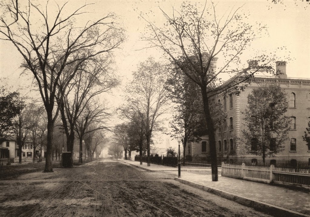
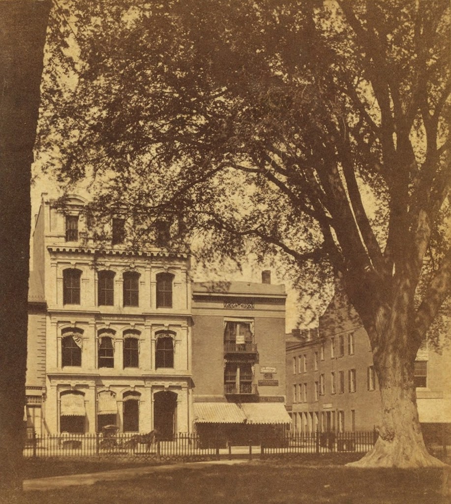
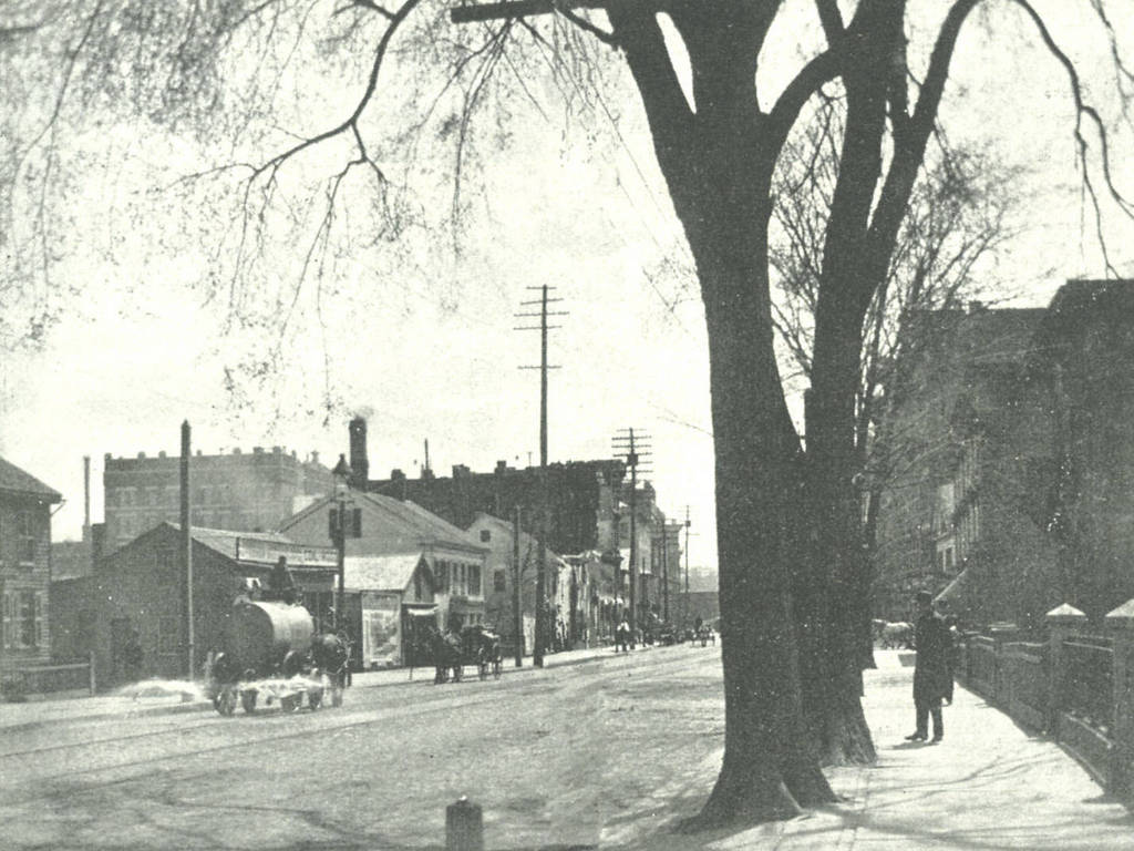
Main Street looking south from Emery Street in Springfield around 1892.  Photo from Picturesque Hampden (1892).
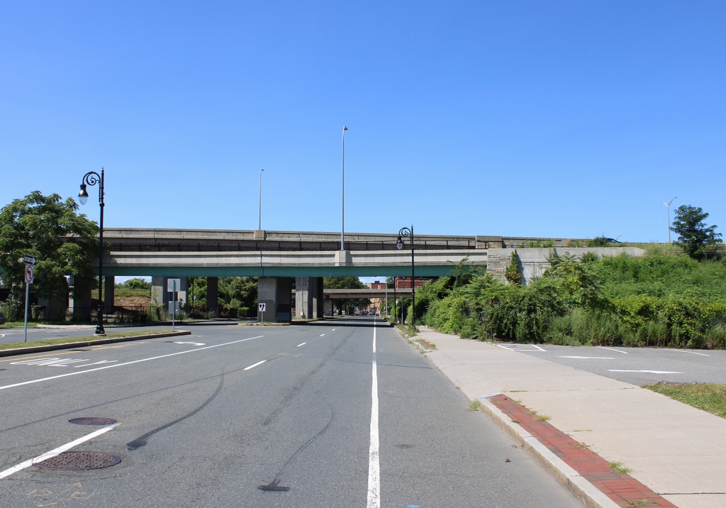
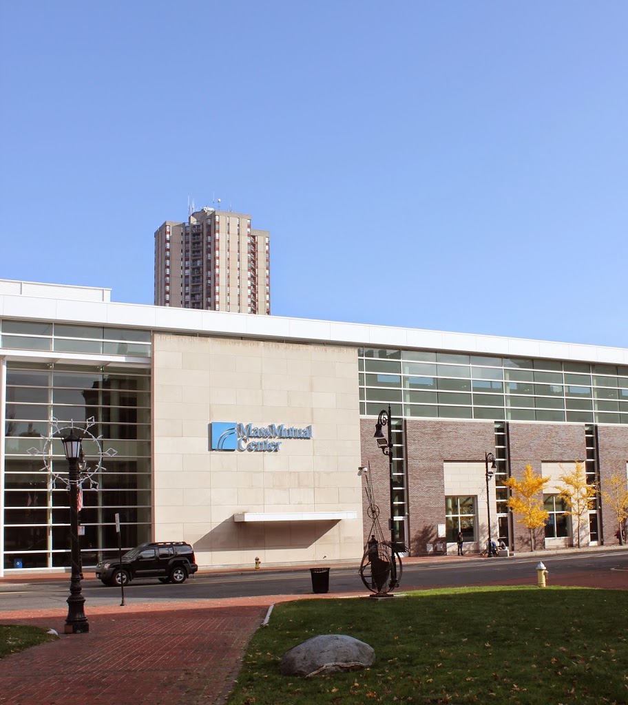
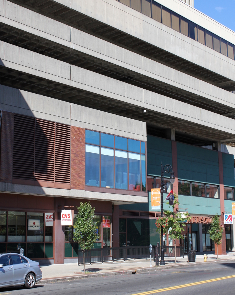
479_1892c picturesquehampden

The scene in 2015:

479_2015

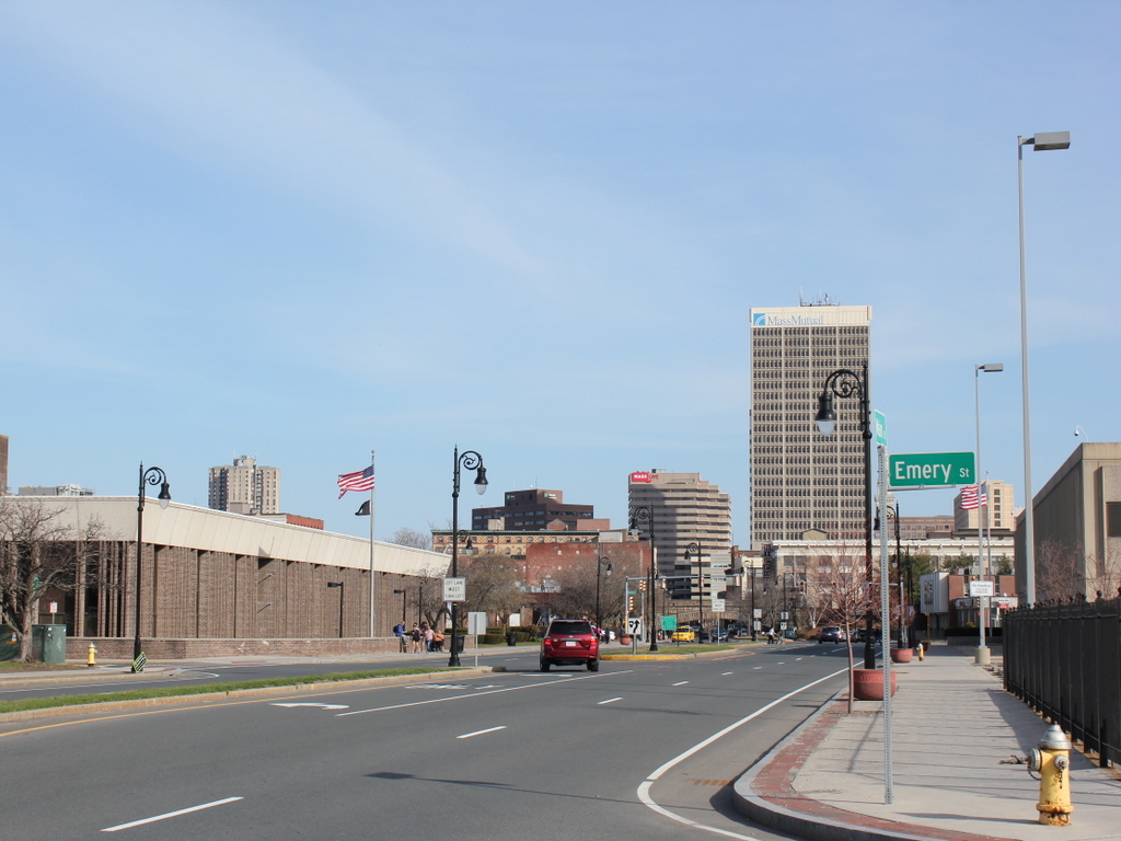
Aside from the railroad arch barely visible in the distance, I’m pretty sure there’s nothing in the 1892 scene that still exists today.  Unlike in other neighborhoods of Springfield, the North End retains very few historic buildings; just about the entire area between the railroad and I-291, extending a block on either side of Main Street, is new development from the 1970s.  The 1920 city atlas shows literally hundreds of houses and other buildings in this area, but today there is not one permanent resident within nearly a quarter mile of this spot.  Instead, there are commercial developments and highways.  The Springfield Republican offices are to the right, and across the street is the US Post Office.  Not visible to the left of the post office is a shopping plaza, and beyond the Republican building on the right is the Peter Pan bus terminal.  In the opposite direction, looking north along Main Street there are several professional offices, and then the sprawling I-291 interchange with I-91, both of which consume substantial real estate in the North End.

North Main Street, Springfield, Mass

Main Street in Springfield, looking toward the North End near Congress Street, around 1882. Photo from Springfield Illustrated (1882).

439_1882c-2Bspringfieldillustrated

The scene in 2023:

The only readily identifiable building in the first photo is on the right side of Main Street, the Hooker School, which was a grammar school that opened in 1865.  In the 1884 King’s Handbook of Springfield, it is described as “the finest of the grammar-school buildings in external appearance,. for which it is indebted to its imposing tower (containing a clock with illuminated dial), as well as to the beautiful network of vines which in summer relieve the bareness of its brick walls.”

The building continued to be used as a grammar school until 1918, and it subsequently became the Continuation School, and then as the girls’ division of the Trade School. It finally closed in 1940, and it was demolished in 1944. Then, about 20 years later most of the surrounding area was demolished as part of an urban renewal plan, which included constructing a large interchange between Interstates 91 and 291, as shown in the second photo.

Main & Court Streets, Springfield, Mass

Looking north on Main Street in Springfield, toward Court Street, around 1882. Photo from Springfield Illustrated (1882).

1880s

Main Street in 2014:

437_2014

This scene is similar to the view in this post, except this one shows the view further down Main Street.  The building in the foreground is the home of the Springfield Five Cents Savings Bank, which is still there today, although its Main Street facade has been completely replaced.  However, the arches over the windows on the Court Street side clearly show that it is the same building.  Further down Main Street in the 1882 photo is the home office of the Springfield Republican, and beyond that is the Mass Mutual Building.

The commercial block furthest from the camera is the Union Block, which is seen in this post from the other side.  Two thirds of this building still exists today, although it is hard to see it in the shadows of the 2014 photo.  Finally, the steeple of the First Baptist Church, which can be seen more clearly in this post.  The church was built in 1847 and demolished in 1888, and today its former location is now Harrison Avenue where it intersects with Main Street.

Main Street from Court Square, Springfield, Mass

Several buildings along Main Street in Springfield, seen from across the street in Court Square, around 1865-1885. Photo courtesy of New York Public Library.

413_1865-1885c-2Bnypl

The view from Court Square in 2014:

413_2014

These photos were taken from Court Square from about the spot that Parsons Tavern once stood, before it was moved to the location in this post.  The massive elm tree in the first photo once stood right next to the building, and George Washington likely would’ve seen the tree upon his arrival nearly 100 years earlier.  Today, the tree is gone, but the street that it was named after – Elm Street – is still there.

The elm tree isn’t the only thing missing in the 2014 photo – the entire area across Main Street was cleared in the 1970s to build the MassMutual Center, a sports arena and convention center where the Springfield Falcons minor league hockey team plays.  According to the 1899 map of downtown Springfield, there were over 70 buildings within the modern-day footprint of the MassMutual Center, along with two streets, Market Street and Sanford Street.  Sanford Street can be seen in the opening between the buildings behind the elm tree, and once ran from Main Street to Dwight Street.

There are several identifiable businesses in the first photo; the white building on the left-hand side was the home of the First National Bank of Springfield, and just to the right of it is the storefront of Frank G. Tobey.  Tobey’s ad in the 1875 city directory indicates that he was a “Dealer in Hats, Caps, and Gent’s Furnishing Goods. Silk Hats made to order.”  Across Sanford Street, none of the signs on the storefronts are visible, but the buildings on that side appear to date to the early 1800s, with a style similar to the Byers Block on Elm Street just across Main Street, which survives today.

Union Block, Springfield, Mass

The corner of Main Street & Harrison Ave in Springfield, Mass, around 1878-1885.  Photo courtesy of New York Public Library.

412_1865-1885c-2Bnypl

The corner in 2017:


This view is very similar to the scene in this post, although the historic photo here is about 30 years older and shows just the buildings along Main Street from Harrison Ave to Court Street. As mentioned in the other post, the building in the foreground here is actually three buildings, which were constructed between 1858 and 1861, and came to be known as the Union Block.  The earliest section, furthest from the camera, is the Republican Block, and it was the home of the Springfield Republican newspaper from 1858 until 1867.  By the time the first photo was taken, it was the home of D.H. Bingham & Co. Clothing House, as seen on the massive sign atop the building.

The Republican Block is the only part of the Union Block that has survived relatively intact to this day.  The middle section, formerly home of Johnson’s Bookstore, is the original 1861 structure, but its facade was completely renovated in 1908 and does not retain any of its original architecture.

Closest to the camera, the northernmost third of the block was home of Kibbe Brothers Co., a large candy manufacturer in the city.  The Union Block was their home throughout the late 1800s, until they moved around the corner to a larger facility on Harrison Ave in 1890, which can be seen in this post.  This part of the Union Block was demolished in 1915, and replaced with the 10 story building that stands there today.

Bill’s Block, Springfield, Mass

Several buildings on the west side of Main Street in Springfield, Mass, near the corner of Bridge Street, sometime in the 1870s. Photo courtesy of New York Public Library.

410_1865-1885c-2Bnypl

The same location in 2017:


The New York Public Library estimates a date range of 1865 to 1885 for this photo, but a single sign on one of the buildings establishes that it had to have been in the 1870s.  The left-most storefront was home to W.D. Kinsman, a dry goods store that later moved a few buildings north in 1880, as seen in this post.  Other businesses visible on signs here include the Springfield Conservatory of Music, J. Wallach & Co., who sold hats, and F.S. Parmenter, another dry goods dealer.

Today, this site is still a major commercial center – the entire block is taken up by Tower Square, the second tallest building in the city.  People also still park along the side of the street, although instead of horses tied to hitching posts like in the first photo, there are cars parked next to meters.