View from Sunset Rock, Catskill, New York

The painting A View of the Two Lakes and Mountain House, Catskill Mountains, Morning by Thomas Cole, 1844. Courtesy of the Brooklyn Museum.

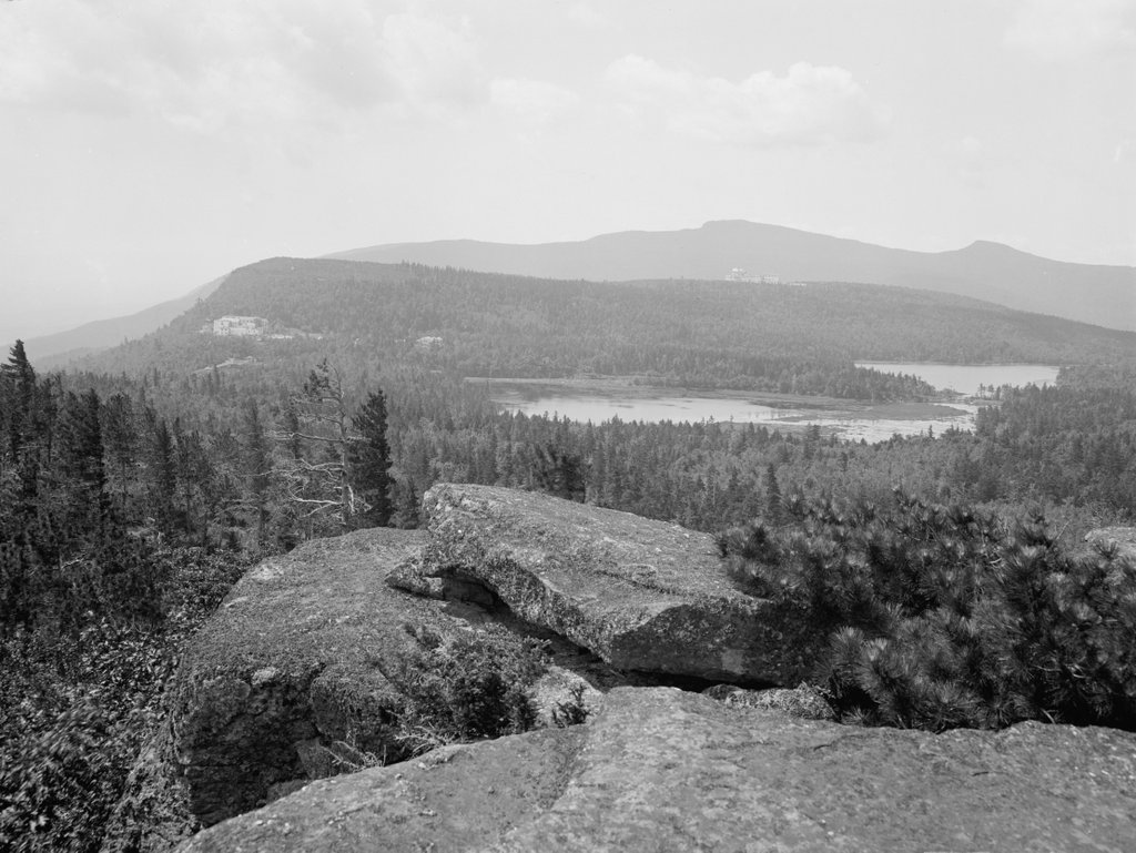
The scene around 1902. Image courtesy of the Library of Congress, Detroit Publishing Company Collection.

The scene in 2021:

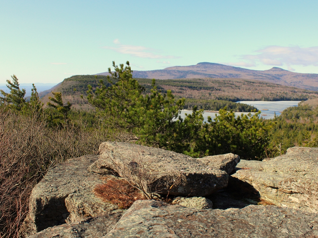
These three views show the scene looking south from Sunset Rock, an outcropping along the Catskill Escarpment just to the north of North-South Lake. The lake, which was originally two separate lakes, is visible in the center of the scene, and beyond it is Kaaterskill High Peak, which rises 3,652 feet above sea level. For many years, this was believed to be the tallest mountain in the Catskills, hence its name, but surveys later in the 19th century proved that it was significantly shorter than Slide Mountain, and today it is ranked as only the 22nd highest in the range. On the far left side is the edge of the escarpment, which drops dramatically in elevation and forms the dividing line between the Catskill Mountains and the Hudson River Valley.

The early 19th century marked the beginning of mountain tourism in the United States, and the Catskills region was one of the first areas to experience this boom. Located along the west side of the Hudson River partway between New York City and Albany, the Catskills were within easy reach, and they offered dramatic scenic views, such as this one here on Sunset Rock. In 1824, the Catskill Mountain House opened near here, on a ledge overlooking the Hudson River Valley at a site known as the Pine Orchard. This was one of the first of many mountain resorts that would be built in the northeast over the course of the 19th century, and it drew many visitors here to enjoy the scenery of the Catskills.

Among the early visitors to the Mountain House was Thomas Cole, a young English-born painter who had immigrated to the United States as a teenager in 1818. He came here for the first time during the summer of 1825, and this visit would prove to have a transformative effect not only on Cole himself, but on the history of American art. He subsequently returned to his studio, where he painted five landscapes of the Catskills and Hudson River Valley, including his first major work, Lake with Dead Trees. These works helped to establish Cole as a prominent landscape painter, and they also marked the beginning of what would come to be known as the Hudson River School, a 19th century American art movement that emphasized dramatic landscapes of the country’s natural beauty.

Thomas Cole eventually relocated to the town of Catskill, where he lived and had his studio. He returned to the Mountain House area many times, but over the years he also expanded his works beyond the Hudson River area, with scenery of Europe, New England, and allegorical landscapes that did not depict a specific location. However, later in his career he painted one last grand landscape from up in the Catskills, shown here in this post. Titled A View of the Two Lakes and Mountain House, Catskill Mountains, Morning, it shows the scene from Sunset Rock, with the Mountain House in the distance on the left side of the painting. As was typical for Cole’s works, it highlights the grandeur of the natural environment. In contrast to the expansive scenery, the only signs of human presence are the small figure in the foreground and the distant hotel, both of which are surrounded by the wilderness.

Nearly 60 years after Thomas Cole painted this view, a photographer captured the same scene with a camera, as shown in the second image. As shown in the photo, remarkably little had changed here since Cole’s visit, and the Catskills remained a popular tourist destination. The Catskill Mountain House was still standing on the left side, although by this point it had been joined by a rival, the Hotel Kaaterskill, which is visible directly below the summit of Kaaterskill High Peak in the 1902 photo. It had been built in 1881, and it stood atop South Mountain, which was about a mile to the southwest of the Mountain House and several hundred feet higher in elevation.

The Hotel Kaaterskill was built by Philadelphia lawyer George Harding, whose motivations evidently had more to do with spite than any other considerations. As the story goes, Harding had visited the Mountain House during the summer of 1880, and during one meal he requested fried chicken for his daughter. However, the kitchen refused to prepare fried chicken since it was not on the menu, and Harding ended up in an argument with owner Charles Beach, who told him he could build his own hotel if he wanted fried chicken. Harding did exactly that, and his Hotel Kaaterskill opened less than a year later. After several expansions over the next few years, it grew to 1,200 guest rooms, and it was said to have been the largest mountain hotel in the world, along with the largest wood-frame hotel in the world.

Mountaintop resorts such as the Mountain House and the Hotel Kaaterskill had enjoyed a heyday during the 19th century, but by the early 20th century the preferences of travelers had begun to change. Part of this was because of the automobile, which opened up new travel opportunities beyond what was accessible by rail. The buildings themselves were also aging, and they were particularly susceptible to fire, given their elevated locations and wood-frame construction. Such was the case with the Hotel Kaaterskill, which was completely destroyed by a massive fire in 1924. As for the Mountain House, it had been one of the first mountaintop resorts, and it managed to outlive most of its contemporaries, but it closed in 1942 and steadily deteriorated over the next few decades. The property was eventually acquired by the state of New York in 1962, and the historic building was deliberately burned the following year.

Today, nearly two centuries after Thomas Cole first visited this area and launched an artistic movement, this scene from Sunset Rock has remained essentially unchanged. In fact, there are actually fewer signs of human activity now than in either the painting or the 1902 photograph, since both hotels are now long gone. The two lakes are now united as one, but otherwise the only hint of modernity in the 2021 photo is a power line that runs along the shoreline of the lake in the center of the photo. This area remains a popular among summer visitors, although they spend their time here in very different types of accommodations. Rather than large, opulent 19th century resort hotels, visitors instead camp at the North-South Lake Campground, which has over 200 campsites, mostly on the north side of the lake.

Rip Van Winkle House, Catskill, New York

The Rip Van Winkle House on Mountain House Road in Catskill, around 1902. Image courtesy of the Library of Congress, Detroit Publishing Company Collection.

The scene in 2021:

The northeastern United States is home to a number of different mountain ranges that form the northern portion of the Appalachians. Colonial-era settlers knew of these mountains, but generally did not place much emphasis on them. Instead, these mountains were often seen through purely practical terms, as poor farmland, barriers to transportation, and places of refuge for wild animals. However, these attitudes began to change by the early 19th century, and many Americans began to appreciate mountains for their untamed natural beauty, in contrast to the rapidly-growing industrial cities of the northeast.

Writers and artists of the period also drew inspiration from the mountains, particularly the White Mountains of New Hampshire and the Catskills here in New York. One of these early works was “Rip Van Winkle,” an 1819 short story by Washington Irving. Set in the pre-revolutionary period, it tells the story of Rip, who goes for a hike in the Catskills to escape his nagging wife. While in the mountains, he encounters the ghosts of Henry Hudson’s crew, who offer him liquor. He drinks and falls into a deep sleep, only to awaken 20 years later. Upon returning home, he finds that his wife is dead and society has been transformed by the American Revolution.

In the story, the narrator describes the place where Rip falls asleep as being “a hollow, like a small amphitheatre, surrounded by perpendicular precipices, over the brinks of which impending trees shot their branches, so that you only caught glimpses of the azure sky and the bright evening cloud.” Irving had never actually been to the Catskills when he wrote the story, so the setting was not based on any specific location, but it did not take long for at least one enterprising individual to capitalize on the story’s fame.

In 1824, the Catskill Mountain House was built on a ledge along the Catskill Escarpment, overlooking the Hudson River Valley. Travelers reached it by way of a carriage road that connected it to the town of Catskill. Along the way, the road passed through this ravine, where it made a U-shaped turn and crossed this brook before heading further up the slope toward the Mountain House. The geography of this ravine resembles the one described in the story, so at some point someone opened a small cabin here, which was styled as the Rip Van Winkle House. Here, travelers could obtain refreshments for themselves and their horses on their way up the escarpment.

It seems unclear as to exactly when the Rip Van Winkle House opened here, and some sources  cite dates in the 1830s or 1840s. However, there was some sort of a structure here as early as 1826, according to a description published in the New-York Mirror in that year:

Two miles from the summit is a small hut, or shantey, as they are called here, whose occupant, by universal consent, bears the name of the immortal sleeper. Whether a genuine descendant or not is a point upon which I will not stake my veracity. His hut is in a singularly romantic situation; built in a deep angle of the rock, with a perpendicular ascent of fifty feet directly above him. He keeps refreshment or travellers, and is supplied with water by a spout which is laid from his window to a spring in the rock behind him.

This original “shantey” was still standing when the first photo was taken at the turn of the 20th century, but by this point it had been joined by a second building, which had been constructed in the late 1860s. This new building was a boarding house, with rates of $10 per week in 1869. It was hardly an opulent hotel, especially when compared to the much larger Catskill Mountain House two miles away, but the intent seems to have been to generate business based on this site’s purported connection to the story. At some point, the owner painted “Rip’s Rock” on a nearby boulder, claiming it to be the spot where Rip slept for 20 years, and this ravine took on the name of Sleepy Hollow, further connecting it to Washington Irving’s literature.

The Rip Van Winkle House remained in business throughout the rest of the 19th century, but it began to decline after 1892, with the opening of the Otis Elevating Railway. This funicular railway provided a direct connection to the Mountain House, eliminating the need for a long stagecoach ride up winding mountain roads. This meant far less business for the Rip Van Winkle House, which ultimately closed shortly after the first photo was taken. The buildings remained vacant for many years afterwards, before finally burning around 1918.

Today, some 120 years after the first photo was taken, the old stagecoach road is still here. Now primarily used by hikers and snowmobilers, it still follows the same route that 19th century visitors to the Mountain House would have taken up the mountain. Here at the site of the Rip Van Winkle House, the buildings have been gone for over a century, but there are still some remnants, including the stone foundations. Aside from the loss of the buildings, though, this scene is not significantly different from the first photo. This remains a quiet, secluded spot partway up the escarpment, and it is an ideal place to stop and rest alongside the stream, although perhaps not for as long as 20 years.

Middle Street, Hadley, Mass

The view looking north on Middle Street towards Russell Street in Hadley, around 1900. Image from History of Hadley (1905).

The scene in 2021:

Hadley is one of the oldest towns in western Massachusetts, having been first settled by European colonists in 1659 and incorporated as a town two years later. Its terrain is mostly flat, and it is situated on the inside of a broad curve in the Connecticut River, giving it some of the finest farmland in New England. The main settlement developed in this vicinity, with a broad town common on what is now West Street. This common was the town center during the colonial period, and it was the site of three successive meetinghouses beginning in 1670.

The third meetinghouse, which is shown here in these photos, was completed on the town common in 1808. This location was a matter of serious contention, as by the turn of the 19th century much of the town’s development had shifted east toward what is now Middle Street. Tradition ultimately prevailed, and the third meetinghouse was built on the common. However, this proved to be only temporary, because in 1841 it was relocated. The intended location was to be a compromise, located halfway between the common and Middle Street, but the movers ignored this and brought the building all the way to Middle Street, to its current location just south of Route 9.

Architecturally, this meetinghouse reflects some of the changes that were occurring in New England church designs. Prior to the late 18th century, the region’s churches tended to be plain in appearance. Many did not have steeples, and those steeples that did exist tended to rise from the ground level on the side of the building, rather than being fully incorporated into the main section of the church. This began to change with prominent architects like Charles Bulfinch, who drew inspiration from classical architecture when designing churches and other buildings. Bulfinch’s churches tended to feature a triangular pediment above the main entrance, with a steeple that rose from above the pediment, rather than from the ground.

Bulfinch does not appear to have played a hand in designing Hadley’s church, but its builder was clearly influenced by his works. It has a pediment with a steeple above it, and it also has a fanlight above the front door, and a Palladian window on the second floor. Other classically-inspired decorative elements include pilasters flanking the front entrance and dentils around the pediment. As for the steeple itself, it does not bear strong resemblance to the ones that Bulfinch designed, but the builder likely took inspiration from other 18th century New England churches. In particular, it bears a strong resemblance the steeples of churches such as Old North Church in Boston and the First Church of Christ in Wethersfield, Connecticut.

Aside from moving the church to this site, the other major event of 1841 that solidified Middle Street as the town center was the construction of a town hall here. Prior to this point, town meetings were held in the church, as was the case in most Massachusetts towns in the 18th and early 19th centuries. Massachusetts was slow to create a separation between church and state, and not until 1833 did the state outlaw the practice of taxing residents to support local churches. Here in Hadley, this soon led to a physical separation between the church and the town government, although as shown in this scene the two buildings stood side-by-side on Middle Street.

While the church features Bulfinch-inspired architecture, the design of the town hall reflects the Greek Revival style of the mid-19th century. This style was particularly popular for government and other institutional buildings of the period, as it reflected the democratic ideals of ancient Greece. The town hall is perhaps Hadley’s finest example of this style, with a large portico supported by four Doric columns, along with Doric pilasters in between the window bays on all four sides of the building.

The first photo shows Middle Street around the turn of the 20th century, looking north toward the church, the town hall, and Russell Street further in the distance. The photo also shows a house on the foreground, just to the right of the church. Based on its architecture, this house likely dated back to about the mid-18th century, but it was gone by 1903, when the current house was built on the site. This house was originally the home of Dr. Frank Smith, and it was designed by Springfield architect Guy Kirkham.

Today, the town of Hadley is significantly larger than it was when the first photo was taken more than 120 years ago. Russell Street is now Route 9, a major east-west thoroughfare that has significant commercial development thanks to Hadley’s position at the center of the Five Colleges region. Likewise, Middle Street is far from the dirt road in the first photo, and it is now Route 47. However, much of Hadley has retained its historic appearance, including its extensive farmland and its many historic buildings. Here on Middle Street, both the church and the town hall are still standing. They have seen few major exterior changes during this time, and the church is still an active congregation, while the town hall remains the seat of Hadley’s town government. Both buildings are now part of the Hadley Center Historic District, which was added to the National Register of Historic Places in 1977.

Mount Tom Railroad, Holyoke, Mass (3)

The trolley Elizur Holyoke approaching the summit on the Mount Tom Railroad, around 1905-1915. Image courtesy of the Library of Congress, Detroit Publishing Company Collection.

The scene in 2021:

The first photo shows the trolley Elizur Holyoke, one of two that operated on the Mount Tom Railroad. Together with the Rowland Thomas, these two cars formed a funicular railway; they were connected by a cable that allowed the descending car to use its weight to help pull the other one up the mountain. This cable, which is seen in the foreground in the middle of the tracks in the first photo, was not powered by a motor at the summit, but instead each car had its own motors, which drew power from overhead wires by way of a trolley pole, as shown atop the Elizur Holyoke in the photo.

The Mount Tom Railroad opened in 1897, allowing visitors to reach the newly-constructed Summit House atop the 1,200-foot Mount Tom. It was just under a mile in length, and it rose 700 feet in elevation, with an average grade of 14 percent and a maximum of 21.5 percent. Most of the route was straight, with the exception of a curve near the summit, which is shown here in this scene. The cars typically ran once every half hour, although they could be operated more frequently depending on demand. Each car could seat 84 passengers, and over the course of an average season the railroad typically carried about 75,000 people to and from the summit.

Aside from the railroad itself, this scene also offers a view of the northernmost portion of the Mount Tom Range, along with part of the Holyoke Range. Appropriately enough, the first photo shows the Elizur Holyoke directly below Mount Holyoke. Both the mountain and the trolley share the same namesake, and the mountain also lent its name to the city of Holyoke, where Mount Tom is located. Further to the left of Mount Holyoke is Mount Nonotuck, which is visible near the upper left corner of the first photo.

When the railroad and Summit House here on Mount Tom opened in 1897, both of these mountains already had long-established hotels at their summits, with the Prospect House on Mount Holyoke and the Eyrie House on Mount Nonotuck. Unlike those businesses, though, the Summit House did not offer overnight accommodations, and instead catered entirely to day visitors. In any case, the aging Eyrie House was never a major competitor to the Summit House, and it ultimately burned in 1901. As for the Prospect House, its 20th century history would largely mirror that of the Summit House, and both ultimately closed in the late 1930s amid declining business during the Great Depression.

The Summit House was demolished around 1938, and the railroad tracks were removed around the same time. Then, in 1944 the property was sold to the radio station WHYN, which built towers and buildings at the summit and converted the railroad right-of-way into a paved access road. Overall, though, this scene has not changed much, aside from the loss of the railroad tracks. The slopes of Mount Tom still look much the same as they did when the first photo was taken, as do the mountains in the distance, although some are obscured by tree growth in the present-day photo. Even the Prospect House on Mount Holyoke is still standing, and it is barely visible as a tiny white speck just to the left of the summit in both photos. Now preserved as a museum, this historic building is one of the few surviving 19th century mountaintop resorts in the northeast, having long outlived its newer competitors on Mount Nonotuck and here on Mount Tom.

Mount Tom Railroad, Holyoke, Mass (2)

The trolley Elizur Holyoke passing through a rock cut on the Mount Tom Railroad, around 1900-1910. Image courtesy of the Holyoke Public Library.

The scene in 2021:

As explained in the previous post, the Mount Tom Railroad was a nearly mile-long funicular railway that brought visitors up to the Summit House at the top of Mount Tom. It opened in 1897, and it featured two trolleys connected by a cable. When one car descended, its weight helped pull the other car up the mountain. Each car also had its own electric motors, powered by overhead wires, which provided additional power to compensate for differences in weight and energy lost to friction. Most of the rail line what a single track, aside from a short turnout at the midpoint to allow the cars to pass.

The railroad rose 700 feet in elevation, with an average grade of 14 percent and a maximum grade of 21.5 percent. The route was mostly straight, although there was a gentle curve near the summit. Along the way, this route required several rock cuts and fills, to maintain a consistent grade. The largest of these cuts is shown here in these photos, about a third of a mile below the summit station. Here, trolleys would pass between two walls of Mount Tom’s distinctive basalt traprock, with its step-like formation.

The first photo shows the trolley Elizur Holyoke, named for the early settler who became the namesake of Mount Holyoke. According to tradition, he and fellow pioneer Rowland Thomas led an expedition up the Connecticut River, with Holyoke traveling up the east side and Thomas on the west side. After reaching an area where the river passes between two mountain ranges, the two men decided to name the eastern one for Holyoke, and the western one for Thomas. Appropriately enough, the other trolley here on the railroad was named the Rowland Thomas.

The Mount Tom Railroad remained in service for about 40 years. Its operating season generally lasted from May through October, and in a typical year would average around 75,000 visitors during the season. Among the most famous of these was President William McKinley, who visited with his wife Ida in 1899 and rode up the mountain on the Elizur Holyoke. Calvin Coolidge and his future wife Grace Goodhue also rode up the railroad in the early 20th century, although with far less fanfare than McKinley had enjoyed, since Coolidge was still an obscure young Northampton lawyer at the time.

The Summit House suffered two disastrous fires, first in 1901 and again in 1929. The second was particularly devastating to the railroad, since its small, hastily-constructed replacement failed to draw the same number of visitors to the summit. This, combined with increased car ownership during the 1920s and the Great Depression of the 1930s, ultimately led to the Summit House and the railroad closing by the late 1930s. In 1938 the Summit House was dismantled, and around the same time the railroad tracks were torn up and removed.

During its many years in operation, the Mount Tom Railroad had a good safety record, and it does not appear to have had any major incidents. However, less than a decade after the railroad closed, this spot here would become the site of a deadly transportation disaster. On the night of July 9, 1946, an Army Air Corps B-17 airplane was en route from Goose Bay, Labrador to Westover Field in Chicopee. The plane had a crew of four, and it also carried 21 passengers who were returning from active duty in Greenland, including 15 Coast Guardsmen, four Army Air Corps servicemen, and two civilians. While attempting to land at the nearby airfield in the dark on a rainy night, the plane instead crashed into Mount Tom, hitting the exposed rock along this section of the railroad grade. The impact disintegrated the plane, killing all 25 men instantly and starting a large fire here. A group of people at nearby Mountain Park climbed up the railroad right-of-way, but they could not get close to the crash scene because of the intense heat, and in any case there was little that they could have done to assist at that point.

Today, more than 80 years after the railroad closed, its route is now a paved access road for the telecommunications towers that occupy the former site of the Summit House. However, there are still remnants of the old railroad along the road, including piles of discarded ties and metal support braces for the utility poles. On a more somber note, however, there are also many remnants of the B-17 crash throughout this area, including pieces of twisted metal and fragments of melted aluminum. The site of the crash is now marked by a monument that is inscribed with the names of the 25 men who died here. It is located about 100 yards in the distance, atop a rocky outcropping on the left side of the road. The monument itself is not visible in the present-day photo, but it can be reached via a short path that starts at the green bush in the distant center of the photo.

Mount Tom Railroad, Holyoke, Mass

The trolley Rowland Thomas on the Mount Tom Railroad in Holyoke, around 1905-1915. Image courtesy of the Library of Congress, Detroit Publishing Company Collection.

The scene in 2021:

The early 20th century was the heyday of electric trolleys in the United States. In the years prior to widespread car ownership, most cities and even many small towns were served by networks of trolley lines that were generally run by private companies. In order to maximize profits, these companies often built picnic groves, amusement parks, and other recreational facilities along their lines. Known as trolley parks, these generated revenue not only through admission fees, but also through increased trolley ridership on otherwise-slow weekends.

Here in Holyoke, the Holyoke Street Railway Company opened Mountain Park in the 1890s. It began as a small park at the base of Mount Tom, but it soon added amenities such as a dance hall, a restaurant, a roller coaster, and a carousel. Most significantly, though, the company also built a summit house at the top of the 1,200-foot mountain, allowing visitors to enjoy the expansive views of the Connecticut River valley. Mountaintop resorts were popular in the northeast during the late 19th and early 20th centuries, and there were already several in the vicinity of Mount Tom, including the Prospect House on Mount Holyoke and the Eyrie House on Mount Nonotuck. However, unlike those establishments, the Summit House here on Mount Tom was not a hotel. Instead, it catered to day visitors, with a restaurant, a stage, and an observatory equipped with telescopes.

To bring visitors to the Summit House, the company constructed the Mount Tom Railroad, a nearly mile-long funicular railway that rose 700 feet in elevation from Mountain Park to a station just below the summit. It had an average grade of 14 percent, with a maximum grade of 21.5 percent at its steepest section. The lower part of the route was straight, as shown here in this view looking down from the midpoint, although there was a gentle curve right before the summit station. Like most funiculars, it consisted of two cars that were connected by a cable. As one car descended, it pulled the other car up the mountain, allowing gravity to do most of the work. The cable itself was unpowered, but the cars each had their own electric motors powered by overhead wires, in order to compensate for weight differences and energy lost to friction.

The two cars were named the Rowland Thomas and Elizur Holyoke, in honor of the early colonists who became the namesakes of Mount Tom and Mount Holyoke. Each car was 36 feet long, 9 feet wide, and could seat 84 passengers. They were connected to each other by a 5,050-foot-long, 1.25-inch steel cable, which passed over a large sheave at the summit. This sheave was mounted on an A-frame that was, in turn, bolted securely into the rock. In addition, the cars maintained constant telephone connection with each other, by way of telephone lines that ran alongside the tracks just above ground level, as shown in the lower left corner of the first photo. The cars connected to these by way of brush-like shoes that ran along the top of the wires as the car moved.

Because of the steep grade of the railroad, the cars’ braking ability was of critical importance, as an uncontrolled descent would likely have had deadly consequences. To prevent this, the cars had several independent braking systems. Each car was equipped with standard trolley brakes, but the cable itself was controlled by a centrifugal governor at the summit that automatically slowed the cable once it began moving faster than 1,400 feet per minute, or about 16 miles per hour. This second feature obviously only worked if the cable remained intact, but there was yet another braking system in the event of a catastrophic failure of the cable. As shown in the first photo, a third rail ran inside the tracks next to the cable. In an emergency, the motorman could activate a lever that would cause the car to clamp on to this rail. This could also be done automatically, by a governor that was set to engage the rail once the car exceeded 1,500 feet per minute, or 17 miles per hour.

In any funicular railway, one of the other challenges is determining how the two cars will pass each other. The simplest solution is to have two parallel tracks, with each car operating on its own track at all times. However, this requires a wider right-of-way, along with significantly more materials than a single-track railway. One alternative is a three-rail funicular, in which each car has its own outside rail and shares the middle one, diverging only at a short passing section. The other option is to have one track for both cars, with a turnout at the halfway point. This requires the least amount of land and materials, but it requires a complex track arrangement at the turnout to ensure each car takes the correct path and safely crosses over the cable.

Here on Mount Tom, the railroad engineers chose the third option, as shown in the first photo. The two cars met at a passing loop, which is visible in the lower center of the photo. At first glance it looks similar to a standard railroad switch, but the key difference is that it has no moving parts. Instead, the cars and tracks are designed so that each one can only take one path, which remains the same regardless of whether the car is heading up or down the mountain. As such, the Rowland Thomas always took the tracks on the north side (the left side when viewed from this direction), while the Elizur Holyoke always took the south side.

To achieve this, the two cars had different wheel arrangements. The wheels on one side of the car had a wider tread than on the other side, which caused them to be guided along deflector rails onto the correct track. For the Rowland Thomas, these wide-tread wheels were on the left side when it was headed uphill, and for the Elizur Holyoke they were on the right side. On the same side as these wheels, each car also had an extra set of wheels that were slightly raised above the others and hung out about 15 inches from the main wheels. Because the turnout required gaps in the main rail to allow the cable to pass through, there was a short section of rail next to these gaps. As the main wheels approached the gap, the auxiliary wheels would roll along this additional rail, preventing what would otherwise be a derailment.

Work on the railroad began in March 1897, and it was completed in time for the summer season, opening on May 25. It operated throughout the summer and into the fall foliage season, before closing for the winter at the end of October. Round trip fare was 25 cents, and included the trolley ride along with use of the Summit House. The trolleys were scheduled to run twice an hour, with extra trips as needed. However, by September this schedule was insufficient to keep up with demand, as indicated by a Springfield Republican article that criticized the railroad for dangerously overcrowded trolleys.

During the early years of the railroad, perhaps its most distinguished passenger was President William McKinley, who visited Mount Tom along with his wife Ida on June 19, 1899. A number of onlookers gathered at the lower station to catch a glimpse of the president, who sat in the front seat of the Elizur Holyoke trolley for the ride up the mountain. At the summit, he and Ida were likewise greeted by a large crowd, and they spent about an hour there, where they ate a light lunch at Summit House before heading back down the mountain.

As it turned out, the McKinleys would be the first of at least two presidential couples who would travel up the Mount Tom Railroad. About five years later, a young Calvin Coolidge and Grace Goodhue visited the mountain on a date. At the time, Calvin was a lawyer in Northampton and Grace was a teacher at the Clarke School for the Deaf. While at the Summit House, he purchased a souvenir plaque of the mountain, which became the first gift he ever gave her. They subsequently married in 1905, and he went on to become governor, vice president, and then ultimately president in 1923.

In the meantime, the original Summit House only lasted for a few years before being destroyed by a fire in 1900. Its replacement opened the following year, but this too would eventually burn, in 1929. By contrast, the Mount Tom Railroad itself appears to have avoided any major incidents throughout its history. However, there were occasional breakdowns that forced passengers to walk down the mountain, and in at least one instance causing a number of people to spend the night in makeshift accommodations at the Summit House.

On July 24, 1928, at around 9:15pm, the Rowland Thomas had to stop about 150 feet from the upper station because of a broken journal on one of its axles. This likewise caused the Elizur Holyoke to stop the same distance from the lower station. The passengers on the Elizur Holyoke were able to easily return to the station, but about 50 people were  stranded at the summit. Many chose to walk down the mountain in the dark, guided by railroad employees with lanterns, but 22 remained at the Summit House overnight. Some stayed up all night, playing bridge and dancing, and most descended the mountain after sunrise, although four guests stayed at the summit until railroad service was restored later in the day. A similar incident occurred less than a month later, when a spread rail stopped the trolleys at about 9:00pm. This time, 35 people walked down in the dark, but it does not appear that anyone spent the night at the summit.

After the 1929 fire at the Summit House, the railroad quickly constructed a temporary replacement at the summit. It had intended to then build a more permanent structure, but by the early 1930s the mountain faced declining numbers of visitors. Part of this was because of the Great Depression, which began just months after the fire here. Another factor was increased car ownership among the middle class, which meant that recreational activities were no longer limited to places that people could access by trolley.

At the base of the mountain, Mountain Park would remain a popular amusement park for decades, but both the Mount Tom Railroad and the Summit House closed in the late 1930s. The temporary Summit House was dismantled for scrap metal in 1938, and around the same time the railroad tracks were taken up and removed. The rails and other metal components were presumably reused or scrapped, but the wooden ties were discarded in piles alongside the right-of-way. More than 80 years later, many of these ties are still in remarkably good condition, and a few are visible in the lower right corner of the second photo.

The railroad ultimately sold the summit area and the right-of-way to the WHYN radio station, which constructed radio towers and transmitter buildings on the site of the old Summit House. The old railroad grade was paved over, and it became an access road for the radio station. As a result, the present-day scene looks very different from the first photo, although there are still a few remnants of the old railroad, including the ties, some discarded spikes, and metal support braces for the old utility poles that once supported the electrified trolley wire.