
The view looking west toward the Burnside Bridge over Antietam Creek in Sharpsburg, Maryland, in September 1862. Photographed by Alexander Gardner. Image courtesy of the Library of Congress, Civil War Glass Negatives and Related Prints collection.

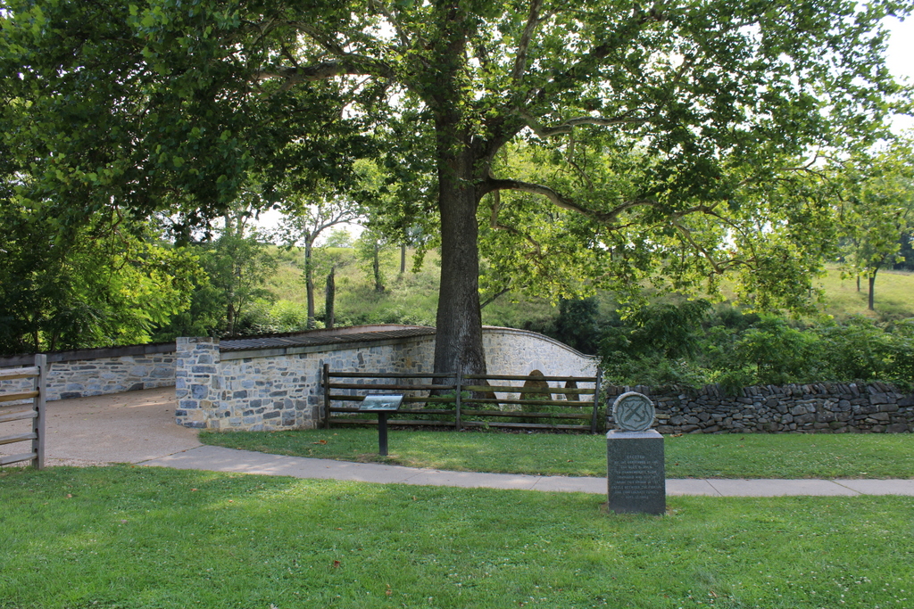
The scene in 2021:
The previous posts have featured some of the most distinctive landmarks on the Antietam battlefield, including the Dunker Church and the Bloody Lane. However, probably the single most iconic landmark at Antietam is this stone arch bridge, which came to be known as Burnside Bridge after the battle. In addition to photographs such as the first one here, the bridge has also featured prominently in numerous paintings of the battle, and even on the reverse of a commemorative coin issues by the U.S. Mint in 1937.
This bridge had been built in 1836 to connect Sharpsburg and the nearby town of Rohrersville. Prior to the battle it was generally known as the Lower Bridge, and it crossed Antietam Creek about a mile to the southeast of the center of Sharpsburg. It was constructed of local limestone, with three arches that spanned the creek.
This previously obscure rural bridge became famous for the events of September 17, 1862, when the Confederate Army of Northern Virginia under Robert E. Lee clashed with the Union Army of the Potomac under George B. McClellan. It was part of Lee’s first large-scale offensive campaign, when he invaded western Maryland as part of an effort to weaken northern morale. Upon reaching Sharpsburg, he set up a defensive position line near the town, and his right flank was positioned here in the vicinity of the Lower Bridge, on the high ground on the opposite side of the bridge in these photos.
Despite having a significantly larger army than Lee, McClellan believed that the opposite was true, and he exercised extreme caution in his attack. He did little to coordinate the movements of his different corps commanders, so it resulted in a piecemeal assault that negated the Union’s significant strength in numbers. The fighting began early in the morning, with an attack on the Confederate left flank near the Dunker Church. After this stalled, the battle shifted to a sunken road that became known as the Bloody Lane. There, after hours of fighting, the Union finally dislodged the Confederates from their makeshift trench, but the heavy losses had made the perpetually risk-averse McClellan unwilling to take the initiative and make an aggressive pursuit.
In the meantime, the southernmost part of the Union line was the IX Corps, under the command of General Ambrose Burnside. He was positioned a little to the east of the Lower Bridge, across the river from the right flank of the Confederates. This portion of the Confederate army was potentially vulnerable, with so many men fighting further north against the attacks on the left flank. However, Burnside did not receive orders from McClellan until around 10:00 a.m. Burnside then used a portion of his corps to find a river crossing downstream to outflank the Confederates, while also making several ineffective charges at the bridge itself.
Despite having a significant numerical advantage, with over 4,000 Union soldiers compared to just 500 Confederate defenders, the Confederates held off Burnside’s corps throughout the morning and into the early afternoon. In the process, the Confederates suffered about 120 casualties, while also inflicting about 500 Union casualties before Burnside finally took the bridge around 1:00 p.m. But, it would take another two hours for Burnside to move his men across the bridge and prepare for a final attack on the Confederate line.
The many delays throughout the battle, combined with McClellan’s ineffective coordination of his generals’ movements, prevented what could have otherwise been a decisive blow against Lee’s army. There were also many who questioned Burnside’s decision to waste time trying to take the bridge, rather than simply having his men wade across the relatively shallow creek. Ultimately, these delays meant that Burnside’s attack on the Confederate flank was countered by the arrival of A. P. Hill at 3:30 with fresh Confederate reinforcements. The final portion of the battle was fought between Hill and Burnside on the hill beyond the bridge, eventually drawing to an inconclusive end around 5:30 p.m.
That evening, Lee withdrew his army and made his way back to Virginia. In abandoning his invasion, it made the Battle of Antietam a strategic victory for the Union, although McClellan had missed the opportunity to make it one of the greatest Union triumphs of the war. He also failed to pursue Lee’s fleeing army, and this decision, combined with his ineffectiveness at Antietam, ultimately led President Lincoln to dismiss him as commander of the Army of the Potomac in early November. And, despite the questionable decisions that Ambrose Burnside had made here at this bridge, Lincoln picked him to replace McClellan. Burnside’s time as commander would prove to be short lived, though, because he was in turn dismissed after his own debacle at the Battle of Fredericksburg in December.
The first photo here in this post was taken only days after the battle. The photographer, Alexander Gardner, arrived at the battlefield on September 19, and he spent the next few days documenting the carnage here. He took a number of photographs of the bridge, which had survived the battle relatively unscathed despite being at the epicenter of intense fighting for several hours. In fact, at first glance the photo does not seem to give the immediate impression that a major battle had just been fought there.
However, on closer inspection, the photo offers clues about what happened here. On the bridge itself, many of the wooden boards are missing from the tops of the walls on either side of the walkway. While some of these may have been damaged in the battle, many of them were removed after the battle and repurposed as makeshift grave markers. In the foreground of the first photo, running along the stone wall to the right of the bridge, is a row of temporary graves, each of which is marked by a board from the bridge. These graves had likely been freshly dug shortly before the photo was taken, and many of the graves are topped by large mounds of dirt.
Following the battle, the bridge reverted to its original use, and this continued well into the 20th century and into the age of automobiles. It finally closed to vehicular traffic in 1966, when a bypass was constructed. More recently, the bridge underwent a major restoration after a portion of one of the walls collapsed into the creek. This project involved resetting the stones and repointing the masonry, and the work was completed in the spring of 2017.
Today, the bridge is part of the Antietam National Battlefield, which is run by the National Park Service. It is one of the best-preserved Civil War battlefields, and the quiet riverbanks here at the Burnside Bridge are a must-see for any visitors. The graves from the first photo have since been relocated, but otherwise this scene looks largely the same as in the first photo, aside from additions such as monuments to the regiments who fought here. Among these is a small monument in the foreground to the 51st Pennsylvania Volunteer Infantry, which was one of the units responsible for taking the bridge. However, perhaps the most remarkable feature in the present-day scene is the large sycamore tree that towers over the bridge in the center of the photo. This is the same tree that was growing next to the bridge during the battle, as shown in the first photo, and it stands as the most famous “witness tree” here on the Antietam battlefield.