Highland Light, Truro, Mass

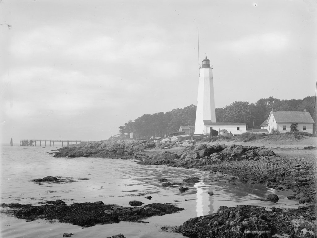
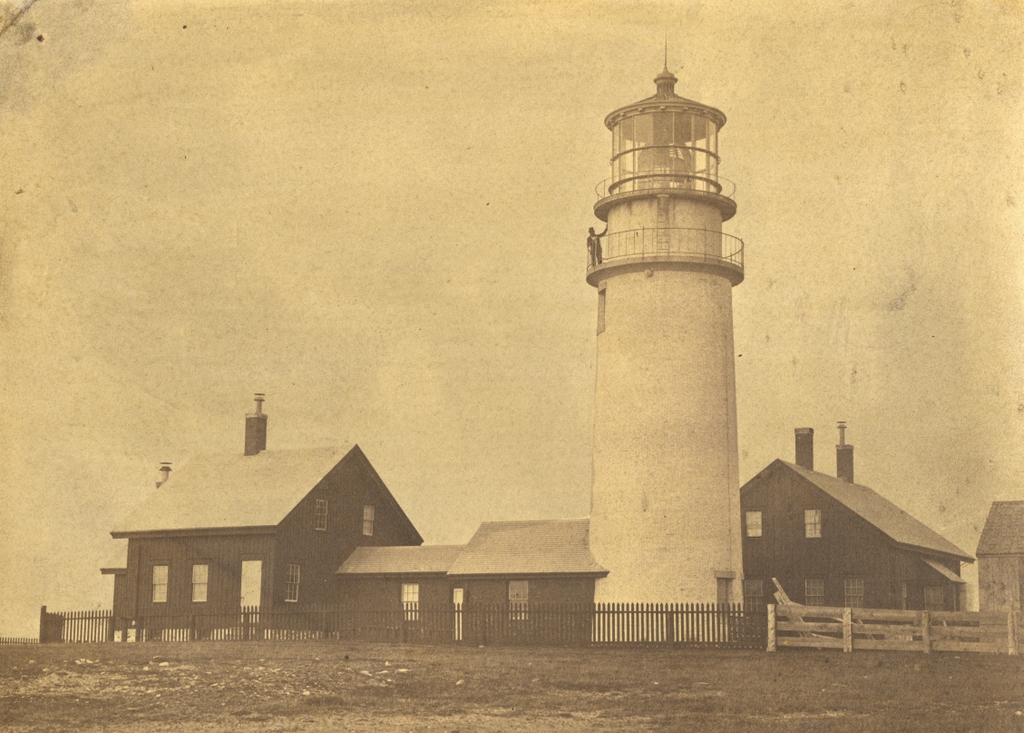
Highland Light, also known as Cape Cod Light, in Truro, Mass, on February 14, 1859. Image courtesy of the National Archives.

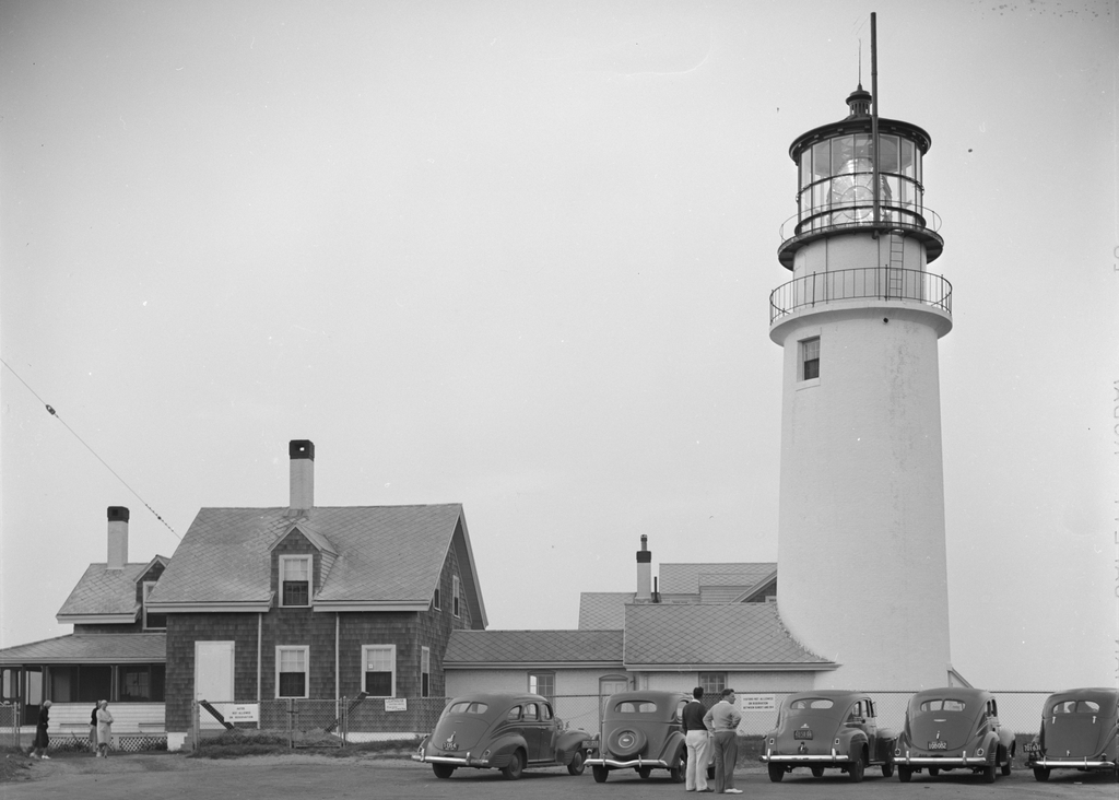
The lighthouse around 1935-1942. Image courtesy of the Library of Congress, FSA/OWI Collection.
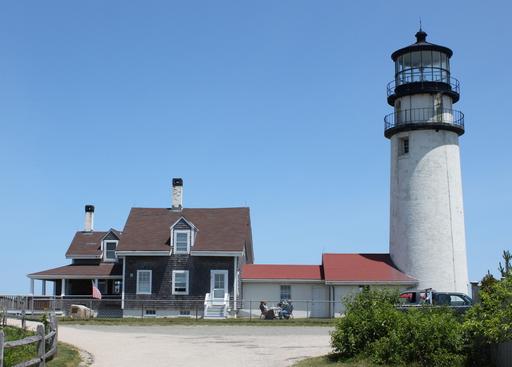
The scene in 2014:

Formed by glaciers at the end of the last ice age, Cape Cod is a long, sandy peninsula on the eastern edge of Massachusetts. It extends outward into the Atlantic Ocean with a hook-like shape that bears resemblance to a flexed arm, and beyond its coastline lies a variety of ever-shifting shoals and sandbars. In the four centuries since European colonization of the area, these attributes have made Cape Cod a significant hazard to navigation, and its shores have been the site of numerous shipwrecks over the years.

The first recorded shipwreck on Cape Cod occurred even before permanent European settlement in the area, when an unknown French ship ran aground sometime around 1617. Many more would follow over the years, including the notorious pirate Samuel “Black Sam” Bellamy, who died 1717 after his ship was wrecked near what is now Marconi Beach in Wellfleet. However, it would be many decades before the first lighthouse was built on Cape Cod to warn mariners away from the treacherous shoreline.

Finally, in 1796, at the behest of a group of Boston merchants, Congress appropriated $8,000 for the construction of the first lighthouse on Cape Cod. The site that was chosen for the lighthouse was here in North Truro, atop the 125-foot cliffs that gave the Highlands area its name. The government purchased ten acres of land, plus a right-of-way, from local resident Isaac Small for $110, and they subsequently hired him as the first keeper of the light, with a salary of $150.

The lighthouse was completed in 1797. It was octagonal in shape and built of wood, and it stood 45 feet tall. It featured a whale oil lantern, and it was evidently the first lighthouse in the country to use an eclipser, which gave it a flashing appearance to distinguish it from Boston Light. Aside from the tower, the light station also included the keeper’s house, a barn, and an oil shed.

The eclipser proved to be unreliable, and the tower itself also had its own problems, with an 1811 report describing it as having been “wretchedly constructed.” Part of the problem was that the tower was too high, so around 1812 it was lowered, and a new lantern was installed atop it. Following these modifications, this lighthouse would remain in service until 1831, when it was replaced by a new 35-foot brick tower.

Like its predecessor, though, the second lighthouse here proved to be similarly deficient in its construction. It was built by Winslow Lewis, a contractor who built many lighthouses along the east coast. However, his works were generally better known for their low costs than for the quality of their construction, and the upper portion of the new lighthouse had to be rebuilt less than a decade later. This part of the project was done by Lewis’s nephew, I. W. P. Lewis, who was by all accounts a far more competent engineer than his uncle.

Despite these improvements, the second tower ultimately proved to be short-lived. It is perhaps most famous as the lighthouse that author Henry David Thoreau visited several times during his visits to Cape Cod in the 1840s and 1850s. He included a chapter on the lighthouse in his book Cape Cod, including an account of how he put his surveying skills to use here and calculated that the cliff was 123 feet above sea level. He also estimated the rate of erosion here, and rather presciently predicted that “erelong, the light-house must be moved.”

Highland Light would ultimately have to be moved, although it would take 140 years before this was necessary, and it was a different lighthouse than the one that Thoreau saw. His last visit to Highland Light occurred in June 1857, and he noted in his journal that “A new lighthouse was built some twenty-five years ago. They are now building another on the same spot.” This lighthouse that he saw under construction was completed later in 1857, and it is the one that is shown here in these three photos.

The new lighthouse was a far more substantial than its two predecessors, standing 66 feet high, with brick walls more than three feet thick at the base. It was equipped with a new French-made Fresnel lens, replacing the 15 Argand lamps and silver-plated reflectors that had illuminated the previous lighthouse. The Fresnel lens cost $30,000, which was twice the cost of constructing the lighthouse itself, and it required a larger crew to maintain. As a result, the one lighthouse keeper here was joined by two assistant keepers. They lived here in two new houses that were connected to the tower by covered walkways. The head keeper lived in the house to the north of the lighthouse, on the left side of this scene, and the assistant keepers lived in the other house, which is visible just beyond the tower in the first two photos.

The first photo was taken less than two years after the new lighthouse was completed. It shows a man, presumably one of the keepers, standing on the lower balcony of the tower. He was probably one of the three keepers listed here in the 1860 census. The head keeper at the time was 55-year-old John Kenney, who lived here with his wife Jane. The first assistant, Hugh Hopkins, was 59, and he lived here with his wife Sarah along with their granddaughter Eliza Knowles and Sarah’s mother Abigail Smith. The second assistant, Thomas Kenney, was the youngest of the three at 50, and his family here included his wife Sarah and their daughters Mary and Elizabeth.

Despite the presence of the lighthouse, shipwrecks continued to occur here along the northeastern shoreline of Cape Cod. During the 19th century there were at least 60 recorded shipwrecks in Truro, many of which were lost with most if not all of their crews. In some cases, multiple ships would be wrecked during a single storm. A snowstorm on December 26, 1872 claimed two sailing vessels, the Peruvian and the Francis, with very different outcomes for the crews. The Peruvian sank with all hands, while the entire crew of the Francis was rescued by volunteers in a whaleboat, although the captain died of an illness several days later. Another deadly storm occurred on January 3, 1878, when 12 sailors died in three different shipwrecks.

The deadliest single shipwreck here in Truro was the Jason, a British sailing ship that was on its way to Boston from Calcutta. The Jason grounded a little north of Ballston Beach, a few miles to the south of Highland Light, during a storm on December 5, 1893. Out of a crew of 25, there was just a single survivor from the wreck. A few years later, these same shores saw the aftermath of one of the deadliest time disasters in New England history, after the passenger steamer Portland was lost off the coast of Cape Ann on November 27, 1898. There were no survivors, and some of the bodies and wreckage washed up here in Truro, despite being about 25 miles from where the ship foundered.

Lighthouse keepers here at Highland Light, as was the case elsewhere, had a variety of responsibilities, including maintaining the lighthouse and other buildings here at the facility. However, their most important duty was to ensure that the light was lit promptly at sunset, remained lit throughout the night, and was extinguished at sunrise. Each of the three keepers worked a shift during the night, with one keeper on duty until 8:00 pm, another from 8:00 to midnight, and then the third from midnight to 4:00 am. Then, at 4:00 the keeper who lit the lamp would return until sunrise.

By the late 19th century, Highland Light was illuminated by a Funck float lamp, which consisted of five concentric wicks of varying diameters. The lighthouse initially burned whale oil, but it later used animal lard and then eventually kerosene. The lamp produced about 500 candlepower of light, which was then greatly amplified by the prisms of the Fresnel lens. The original 1857 lens increased the intensity of the light roughly twentyfold, creating a fixed beam of about 10,000 candlepower. However, by the turn of the 20th century this was insufficient for the needs of maritime traffic, so in 1901 the old lens was replaced by a new first order Fresnel lens. The old lamp was retained, but the new lens further amplified its intensity to about 192,000 candlepower, or nearly 400 times the intensity of the lamp itself. The new lens also rotated, creating a flashing effect that made it much more noticeable at sea than the old fixed lens. A temporary light tower was in use here while the lenses were changed, and the new lens went into use on October 10, 1901.

The second photo was taken around 1940, as shown by the license plates on the cars in the foreground. The massive Fresnel lens is clearly visible in the lantern room, but in 1932 the old oil lamp had been replaced by a thousand-watt electric bulb. This gave the light an intensity of four million candlepower and a range of up to 45 miles, making it one of the most powerful lighthouses in the country. By this point, many American lighthouses had been automated, but Highland Light was still manned by resident keepers. However, this was far from the isolated outpost that Thoreau had visited nearly a century earlier. Automobiles had made the outer parts of the Cape far more accessible than before, and the photo shows a number of tourists here, including two cars from New York and one from Ohio. One sign on the fence indicates that the lighthouse visiting hours are from 10:00 am to noon, and then from 2:00 to 4:00 pm. Another sign advises that the grounds are closed to visitors from sunset until 9:00 am.

The head keeper at the time of the second photo was William A. Joseph. He had served here at Highland Light since the early 1920s, and he held the position of assistant keeper until 1935, when he was promoted to head keeper. By 1940 he was 52 years old, and he lived here with his wife Nellie. That year’s census lists his salary as $1,500, while the two assistant keepers earled $1,320 and $1,260. He remained here until his retirement in 1947, and he appears to have been the last civilian keeper at the lighthouse before the Coast Guard took over the operation of the light station.

Overall, despite being taken more than 80 years apart, the first two photos do not show major changes to the lighthouse or adjacent keepers’ houses. The alterations to the houses were mostly superficial, including the addition of a porch and a dormer window on the head keeper’s house, along with shingles that replaced the earlier vertical boards on the exterior of the houses. The lighthouse itself barely changed in the period between the two photos, aside from the upgraded lens and the addition of some sort of a pipe next to the lantern room.

By contrast, the second and third photos were taken less than 75 years apart, yet they show far more substantial change here at Highland Light. The old Fresnel lens only lasted a few more years after the second photo before being removed in the late 1940s and replaced by an aerobeacon. Then, in 1961 the assistant keepers’ house was demolished, and a new ranch-style duplex was built just to the southeast of the lighthouse. The lighthouse would remain actively staffed by Coast Guard keepers for several more decades after this, but it was ultimately automated in 1986 and a new aerobeacon was subsequently installed.

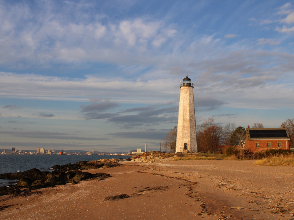
As lighthouses around the country were automated during the mid to late 20th century, this often led to the deterioration of the keeper’s houses and other associated buildings, which were typically rendered obsolete. However, here at Highland Light it was not just the keeper’s house that was endangered in the late 20th century. By the early 1990s, Thoreau’s prediction that the lighthouse would need to be moved was fast becoming a reality. The 1857 lighthouse was built on the same spot as its predecessors, which had been more than 500 feet from the cliff when the first one was completed in 1797. By the 1990s, though, the ocean’s steady erosion of the sandy cliffs had reduced this distance to just over a hundred feet.

The only real option for saving the lighthouse was to move it, but moving a 66-foot-tall, 450-ton masonry structure is no easy task, especially one that is nearly 140 years old. The lighthouse was first stabilized with a series of vertical two-by-fours that were strapped to the tower with steel wire. Then, 20 steel beams were inserted through the foundation, with two support beams laid perpendicular underneath these beams. These support beams were then slowly pushed along seven parallel roller beams. There were two sets of these roller beams, and the sets were alternated as the lighthouse moved along the beams. It took 18 days to move the lighthouse 450 feet west and 12 feet south of its original location, and the move was completed on July 29, 1996. The keeper’s house was not moved at the same time, but it was later moved and reattached to the lighthouse.

As a result of the move, the 2014 photo was taken a few hundred feet west of where the first two photos were taken, although it faces the same direction and shows the same view of the lighthouse as the other photos. The lighthouse remains an active aid to navigation, standing as both the oldest and tallest on Cape Cod. In the years since this photo was taken, the lighthouse has undergone a major restoration, including repairing the masonry, replacing or repairing corroded metal, installing a new ventilation system, and repainting the exterior. The lighthouse and keeper’s house have been closed to the public during this time, but they are expected to reopen for the upcoming 2022 season.

Five Mile Point Light, New Haven, Connecticut

The Five Mile Point Light at the entrance to New Haven Harbor, around 1900. Image courtesy of the Library of Congress, Detroit Publishing Company Collection.

The scene in 2021:

New Haven Harbor has been marked by a lighthouse since 1805, when the first one was constructed here on this site at the southeast edge of the harbor. It was commonly known as Five Mile Point Light, because of its distance from downtown New Haven. The original tower was 30 feet tall and built of wood, but by the late 1830s both it and the keeper’s house were badly deteriorated. Both buildings were replaced in 1847, and the new lighthouse was substantially larger than the older one. As shown in these two photos, it is octagonal in shape and constructed of local brownstone, and it stands 80 feet above the ground. Its design is very similar to many of the other early 19th century lighthouses in Connecticut, including New London Harbor Light, Lynde Point Light, Black Rock Harbor Light, and Falkner Island Light.

The new lighthouse was constructed by local builder Marcus Bassett, and the work evidently progressed quickly. Congress appropriated funds for it on March 3, 1847, and it was nearly completed by September, when an article appeared in the New Haven Journal, praising the new lighthouse:

New-Haven harbor during easterly storms, is the refuge of an immense number of craft, but its entrance from the east has always been difficult, if not dangerous, because the light-house cannot be seen until near the rocks upon which it stands. The government erected a new house for the keeper recently, but the new light-house, which is nearly ready for use, is the object of special admiration. Standing but a few rods from the old one, it rises in towering majesty by its side, and now may be seen in every direction where the other was wholly concealed. It will be of immense benefit to New-Haven harbor and also add to the security of the navigation of the Sound.

As was the case with most other American lighthouses of the era, Five Mile Point Light was maintained by a keeper who resided here on the property. Lighthouse keepers were primarily responsible for lighting and extinguishing the lantern, but other routine duties included maintenance and repairs to the buildings and equipment. However, because of their locations at hazardous points along shipping routes, keepers were also occasionally called upon to assist sailors in distress. Here at Five Mile Point, keeper Merritt Thompson, who served from 1853 to 1860, was often involved in such rescues, with his 1884 obituary noting that “when he was keeper of the lighthouse it was his good fortune to be instrumental in saving lives on a number of occasions when boats would be upset in the harbor,” and that “many stories are told of his daring and humanity in emergencies calling for personal risk and quick action.” 

The 1860 census shows Thompson living here at the lighthouse with his wife Julia and their six children, who ranged in age from 11 months to 14 years. However, he was subsequently dismissed from the post, and went on to work as a harbor pilot here in New Haven. An 1861 letter to the editor, published in the Columbian Register, suggested that this was a political move, and that he was replaced by a Republican partisan because of Abraham Lincoln’s electoral victory in 1860. The writer questioned the qualifications of any replacement, and observed that “the removal has caused a burst of indignation among all our citizens,” and concluded the letter with some sarcasm, saying “I trust none of our citizens will allow themselves to be capsized in the vicinity of the light house, for the next four years.”

The new lighthouse keeper was Elizur Thompson, who was not related to his predecessor. Despite this anonymous writer’s doubts about his abilities, he go on to serve here for many years, first as a keeper and later as an employee of the United States Signal Service. His family also helped maintain the lighthouse, including his wife Elizabeth and two of their sons, each of whom received assistant keeper salaries at various times over the years. He was dismissed in 1867 by the Andrew Johnson administration, for reasons that were evidently as political as his initial appointment had been, but he was subsequently reappointed in 1869, after Republican Ulysses S. Grant became president.

During the 1870 census, Elizur and Elizabeth were 61 and 59 respectively, and they lived here at the lighthouse with their 24-year-old son George and their 18-year-old daughter Ella. However, Elizabeth died a year later, and in 1877 Elizur remarried to Ellen Pierce, a widow who was about 30 years younger than him. She had a son, Burton, from her first marriage, and he was 13 years old and living with them during the 1880 census.

In the meantime, in 1873 the federal government began construction of Southwest Ledge Light, located on a rocky ledge about a mile offshore from here. Because this new lighthouse was much closer to the main shipping channel, it rendered Five Mile Point Light obsolete, and the light was deactivated after Southwest Ledge was completed in 1877. Elizur Thompson was then appointed as the first keeper of the new lighthouse, and his son Henry became the assistant keeper. He remained there for four more years, until his retirement in 1881, and Henry then became the main keeper of Southwest Ledge.

Following his retirement, Elizur and Ellen returned to the old Five Mile Point Light, where he was allowed to live, rent-free, for the rest of his life. During this time, he worked for the United States Signal Service, displaying flags from the old lighthouse to provide weather reports for passing merchant vessels. Both Elizur and Ellen faced health scars in the mid-1880s, beginning with a head injury that the elderly Elizur suffered in 1884, when he slipped and hit the back of his head on a rock while trying to launch a boat here on the beach. Then, in June 1885 Ellen underwent major surgery in New York to remove a large tumor. Newspaper reports described her as being in critical condition and doubted whether she would survive, but she ultimately recovered and returned to New Haven in early August.

Elizur carried out his duties here at the lighthouse until his death in 1897, when he was 87 years old. Ellen had taken over these responsibilities during his final illness, and after his death she was formally appointed as his successor. As described in the Morning Journal and Courier following her appointment, the signal station “has been a great boon to the sailors, since it has warned them of impending storms and furnished them the opportunity to come within the shelter of the harbor.” The article described how the weather reports arrived in downtown New Haven and were then telephoned to the lighthouse, where Ellen would hoist the appropriate flags. The article then concluded by remarking that “the task is anything but an easy one for a woman, especially in stormy weather.” She would retain this post until her death in 1901, at the age of 60.

The first photo was taken around 1900. Assuming this date is accurate, Ellen Thompson would have still been living and working here, and the tall pole atop the lighthouse was likely where she hoisted the flags. The photo also shows the keeper’s house on the right side, connected to the lighthouse by an enclosed wooden walkway. On the other side of the lighthouse, in the center of the photo, are four Civil War-era Rodman cannons that were installed here during the Spanish-American War in 1898. These obsolete guns were evidently more for show than anything else, and were likely more effective at reassuring locals than at dissuading Spanish warships. In any case, these guns were never tested in combat during the short-lived war, and within a few years they were removed and incorporated into several different local Civil War memorials.

No longer necessary for either navigational aids or civil defense measures, this area around the old lighthouse subsequently became an amusement park, known as Lighthouse Point Park. Like many other early 20th century amusement parks, it was developed by a local trolley company as a way of increasing ridership on otherwise quiet weekend trolleys. The park featured attractions such as a carousel, along with a beach and fields for athletic events. Even prominent baseball stars such as Babe Ruth and Ty Cobb made appearances here at Lighthouse Point and participated in exhibition games.

The amusement park was subsequently acquired by the city, but it began to decline after the 1920s, and most of the park buildings were demolished by the mid-20th century. The site has continued to be used as a public park, though, and it continues to be a popular destination for its beach and for other recreational activities, including its restored carousel. However, the most prominent landmark here at the park continues to be the historic lighthouse. Despite not having been used as a lighthouse for nearly 150 years, both the tower and the keeper’s house are still standing, with few major changes since the first photo was taken, aside from the loss of the covered walkway.

Lost New England Goes West: Alcatraz Island, San Francisco (2)

Another view of Alcatraz Island, taken around 1900. Image courtesy of the National Park Service.

903_1900c nps

The view in 2015:

The first photo here was taken around the same time as the one in the previous post, showing Alcatraz Island when it was being used as a military prison. At the time, the island’s inmate population was rapidly growing, and within a few years many of the Civil War-era buildings in this scene would be demolished to build modern facilities. Building 64, the large building along the water in the present-day scene, was built in 1905 to house the officers who were stationed here. In 1909, the current lighthouse was built to replace the original 1854 structure, which had been damaged in the 1906 earthquake. Around the same time, the old Alcatraz Citadel, barely visible at the top of the hill, was demolished to build the main prison building. Completed in 1912, it was later converted from a military prison into a federal civilian prison, and still stands at the top of the island today.

The only building left from the first photo is the Guardhouse on the far right. Built around 1857, it is the oldest remaining structure on the island, dating back to the time when the island was used as a defensive fortification to protect San Francisco Bay. It was also used as the island’s first prison building in the 19th century, before the island’s role as a prison was expanded and purpose-built prison structures were added. Today, more than 50 years after the last prisoner left Alcatraz, the Guardhouse and the rest of the historic buildings on the  island are administered by the National Park Service, and the island is open to the public as part of the Golden Gate National Recreation Area.

This post is part of a series of photos that I took in California this past winter. Click here to see the other posts in the “Lost New England Goes West” series.

Lost New England Goes West: Alcatraz Island, San Francisco

Alcatraz Island in San Francisco Bay, around 1902-1905. Image courtesy of the National Park Service.

902_1902-1905c nps

Alcatraz in 2015:

Alcatraz Island is located at a strategic point just inside the entrance to San Francisco Bay. The United States acquired California in 1848, and within ten years this small island had been fortified to protect the bay from any potential threats. Known as the Alcatraz Citadel, it was finished just in time for the Civil War, and although it never saw any combat during the war, its isolated location made it an ideal place to house Confederate prisoners.

After the war, the focus on Alcatraz shifted from defense to incarceration, and from 1868 to 1933 it functioned as a military prison. The first photo was taken during this era, showing a number of buildings on the island that were used to house either the inmates or the military personnel stationed there. At the top of the hill in the first photo is the Alcatraz Citadel, which was demolished a few years later to build the main prison building that stands there today. Most of the other buildings from the first photo have since been demolished, including those along the water, which were replaced by Building 64 in 1905. This large building, which was originally used to house military officers and their families, is still standing today just to the right of the center of the photo.

When the military prison closed in 1933, the property was transferred to the Department of Justice, and in 1934 it reopened as a civilian prison for the nation’s most difficult prisoners. Considered essentially escape-proof, there were never any confirmed successful escapes, although three inmates did disappear in the famous 1962 attempt. Alcatraz was expensive to maintain, though, and it closed in 1963. After the closure, the island was occupied by Native Americans for 19 months in 1969-1971, during which time several of the buildings were burned. Later, the island was acquired by the National Park Service, and is now open to the public as part of the Golden Gate National Recreation Area.

This post is part of a series of photos that I took in California this past winter. Click here to see the other posts in the “Lost New England Goes West” series.

Portland Head Light, Cape Elizabeth, Maine (3)

Another view of Portland Head Light, probably taken around the 1870s. Image courtesy of the New York Public Library.

741_1865-1883c nypl

The lighthouse in 2015:

741_2015
The first photo here was probably taken around 10-20 years before the ones in the previous two posts here and here, and it shows the tower as it appeared following its 1865 height change.  As mentioned in more detail in the first post, the lighthouse was built in 1791, but was reduced in height by 20 feet in 1812, to the spot below the lantern where a horizontal band runs around the tower.  Those 20 feet were restored in 1865, as seen in the first photo, but the tower was trimmed down again in 1883.  Just two years later, though, enough sailors complained that it was raised 20 feet yet again, with changes such as a larger lantern room at the top and  a second gallery below it.  Since 1885, it hasn’t seen very many changes, and it remains an active lighthouse as well as a popular tourist destination along the southern coast of Maine.

Portland Head Light, Cape Elizabeth, Maine (2)

Another view of Portland Head Light, taken from the north side probably around 1890. Image courtesy of the Library of Congress, Detroit Publishing Company Collection.

740_1900-1910c loc
The lighthouse in 2015:

740_2015
The angle here isn’t exact; the first photo was taken from the water, a little to the left of where the 2015 photo was taken.  The previous post explains more about the history of the lighthouse, which was built in 1791 on a rocky outcropping at the entrance to Portland Harbor.  The first view was presumably taken around the same time as the one on the other post, because it shows the old 1816 keeper’s house, which was replaced by the current one in 1891.

Being surrounded by water on three sides and facing the open ocean provides some dramatic views for visitors and photographers, and it probably also provided the inspiration for Henry Wadsworth Longfellow’s poem “The Lighthouse.”  Longfellow grew up in Portland, and the certainly seemed to be describing this lighthouse, writing in the first two stanzas:

The rocky ledge runs far into the sea,
And on its outer point, some miles away,
The Lighthouse lifts its massive masonry,
A pillar of fire by night, of cloud by day.

Even at this distance I can see the tides,
Upheaving, break unheard along its base,
A speechless wrath, that rises and subsides
In the white lip and tremor of the face.

The lighthouse would have looked a little different when Longfellow wrote the poem, though.  The keeper’s house would have been the same as the one in the first photo, but as mentioned in the previous post, its height was periodically changed throughout the 19th century, and did not assume its present-day appearance until 1885, three years after Longfellow’s death.  Today, with the old keeper’s house gone, the only thing left from Longfellow’s childhood visits is the section of the tower below the horizontal band a little below the lantern.