Carrollton Viaduct, Baltimore, Maryland

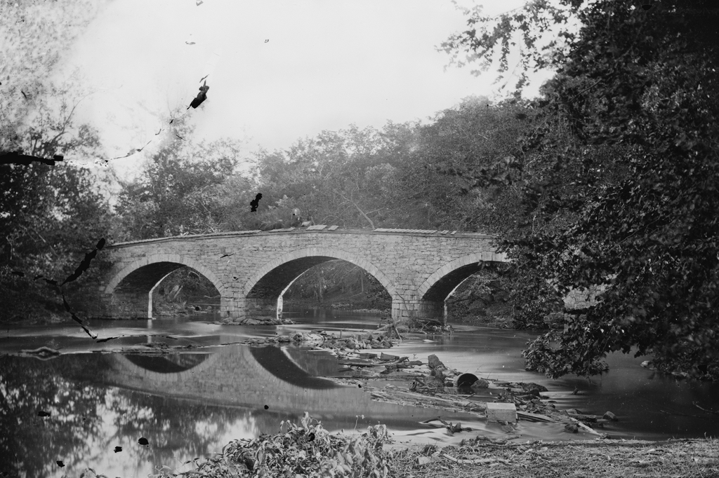
The Carrollton Viaduct over Gwynns Falls in Baltimore, around 1921. Image from the October 1921 issue of the Baltimore and Ohio Employees Magazine.
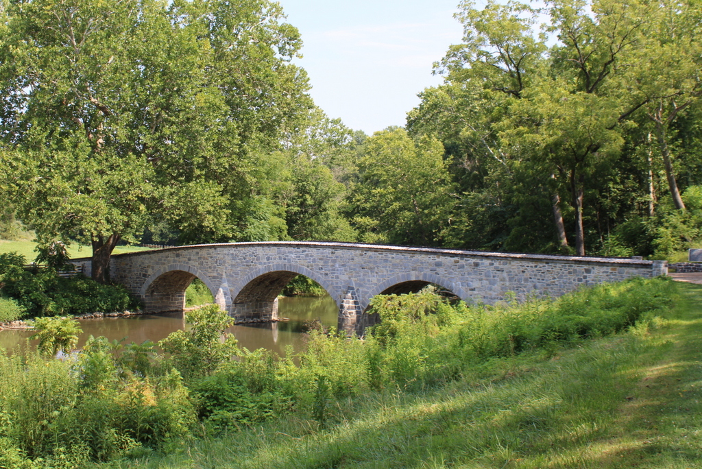
The scene in 2021:

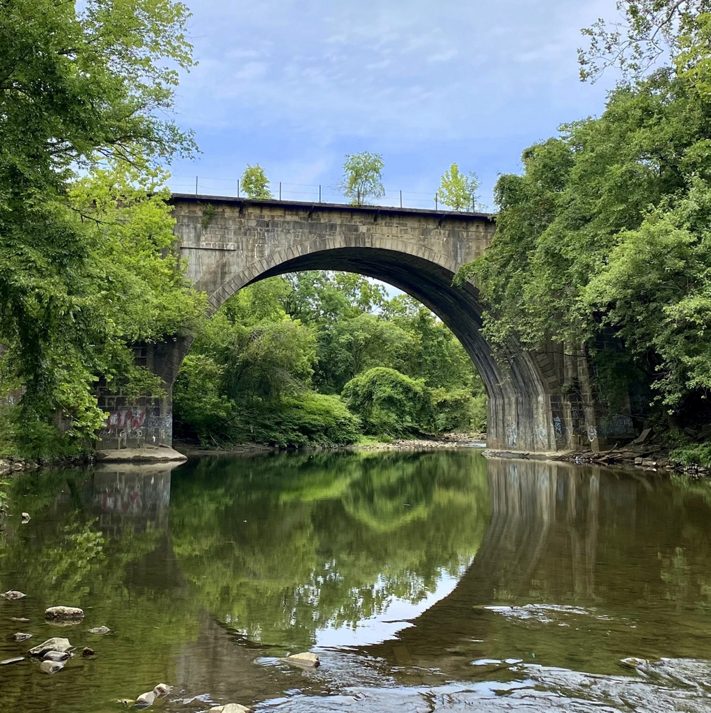
These two photos show the view of the Carrollton Viaduct from the east, where it passes over the Gwynns Falls stream. This bridge is a significant civil engineering landmark, as it was the first masonry arch railroad bridge in the United States, and today it remains in use as the country’s oldest active railroad bridge.

The bridge was constructed by the Baltimore and Ohio Railroad, which, depending on the criteria used, is often regarded as the first railroad in the United States. Prior to the 1830s, the primary means of inland transportation in the United States were turnpikes and canals. However, investors in Baltimore saw the potential of the newly-emerging railroad technology, and in 1827 they organized the Baltimore and Ohio Rail Road Company. This was not necessarily the first railroad in the country, as there were much smaller ones that predated it, but this was a far more ambitious plan, to construct a railroad westward from Baltimore, through the Appalachians, and to the Ohio River.

It would take many years before that goal would be completed, but in the meantime the railroad made significant progress here in the vicinity of Baltimore. Work on the railroad began on July 4, 1828, with a ceremony that featured Charles Carroll laying the cornerstone. Sources seem unclear as to whether that cornerstone was specifically for this bridge, or if it was at a different part of the railroad line, but either way it was a highly symbolic event. Carroll, aged 90, was the last living signer of the Declaration of Independence, so his presence provided an important link between the country’s founding principles and its new visions of industry and technological improvements.

Regardless of where the actual cornerstone ceremony occurred, this bridge would be one of the first of many engineering challenges that the new railroad would face as it worked its way westward from Baltimore. Here, the railroad had to cross over Gwynns Falls, a stream that was flanked on both sides by high embankments. Railroad superintendent Casper Wever was tasked with designing the bridge, and his initial plans called for a single 50-foot arch over the stream. However, because of concerns about flooding, this was changed to an 80-foot arch over the stream, along with a smaller 16-foot arch over a road that ran parallel to the stream on the left side of this scene.

In the end, the finished bridge was 312 feet long, and it rose 51 feet, 9 inches above the water. The work was completed in the fall of 1829, and it opened on December 21, 1829, in another ceremony that was attended by Charles Carroll. This time, he laid the final stone of the parapet, and the bridge was formally named the Carrollton Viaduct in his honor. The Baltimore Gazette And Daily Advertiser, reporting on the event the next day, provided the following account:

The Bridge over Gwynn’s Fall’s was yesterday completed by the laying of the last stone on the Eastern extremity of the South parapet. Carroll of Carrollton, our venerated fellow citizen, the last living signer of the Declaration of Independence, presided at the ceremony, and the Bridge, in pursuance of a resolution of the Board of Managers, was named after him—”The Carrollton Viaduct.” In the short & very appropriate address of Mr. Lloyd, the builder of the Bridge, to Mr. Carroll, he says that he does not ask for it a longer duration than the same of the last surviving signer; and we have no doubt that the Bridge will be found uninjured by time so long as the rocks upon which it is based shall stand. It speaks the character of the great work whose commencement it ornaments—firm as beautiful—useful as enduring.

As it turned out, Lloyd’s modest hope that his bridge would enjoy the same longevity as its namesake proved to be a considerable understatement. At the time, Carroll was 92 years old, and the first photo in this post was coincidentally taken about 92 years after the bridge was completed. By this point, the bridge was still going strong after nearly a century, even as rail traffic over the bridge had evolved from small horse-drawn trains of the 1820s, to the large steam locomotives and heavy freight cars of the 1920s.

Today, another century has gone by since the first photo was taken. The Baltimore and Ohio Railroad no longer exists, having been absorbed by other companies in a series of mergers. However, this line is still an active railroad operated by CSX Transportation, and the nearly 200-year-old stone bridge still carries modern rail traffic over Gwynns Falls. Because of its pioneering role in the early years of railroad development in the United States, the bridge was designated as a National Historic Landmark in 1971, and in 1982 it was similarly named a National Historic Civil Engineering Landmark.

Burnside Bridge, Sharpsburg, Maryland (2)

The view of the north side of the Burnside Bridge, from the west bank of Antietam Creek, in September 1862. Photographed by Alexander Gardner. Image courtesy of the Library of Congress, Civil War Glass Negatives and Related Prints collection.

The scene in 2021:

As explained in more detail in the previous post, the Burnside Bridge—or lower bridge, as it had previously been known—was the focal point of the later phase of the Battle of Antietam on September 17, 1862. Ahead of the battle, the Confederates under Robert E. Lee had taken a defensive position near the town of Sharpsburg, with a line of soldiers that extended north to south. The southern end of his line was anchored on the heights just to the west of this bridge, and this led to intense fighting for control over the bridge.

Opposing the Confederates in the vicinity of the bridge was General Ambrose Burnside, whose IX Corps was positioned to the east of here, in the distance on the left side of this scene. However, because of poor coordination on the part of the Union commander, General George B. McClellan, Burnside received no orders until around 10:00 a.m., long after the fighting had begun on the northern part of the battlefield.

Despite the bridge being defended by only 500 Confederate soldiers, it took Burnside’s 4,000-man corps several hours to take the bridge, suffering about 500 casualties in the process. The Union forces finally took the bridge around 1:00 p.m., but Burnside delayed in moving his men, and they did not all cross until around 3:00 p.m. This gave the Confederates time to gather reinforcements, and rather than striking a decisive blow at the Confederate line, Burnside’s soldiers were faced with fresh Confederate soldiers commanded by A. P. Hill. The final portion of the battle occurred on the heights to the west of the bridge, to the right of where these photos were taken, and it was largely inconclusive, with Burnside’s soldiers managing to hold the bridge but unable to gain much ground.

The bridge came to be known as Burnside Bridge in his honor, although his actions here did face criticism. Some criticized his delays in moving his corps over the bridge, while others questioned whether the Union could have simply waded across the shallow creek, rather than making a costly and time-consuming effort to seize the bridge. Nonetheless, he was subsequently promoted to command of the Army of the Potomac in November, but he was ultimately dismissed after the disastrous Battle of Fredericksburg, which likewise involved a time-consuming crossing of a waterway.

The first photo was taken only days after the battle, by prominent Civil War photographer Alexander Gardner. Today, not much has changed here in this scene. The bridge is still standing, as is one of the trees from the first photo. Barely noticeable on the far left side of the first photo is a small sycamore tree, which now towers over the bridge in the present-day scene. It is the most famous “witness tree” at Antietam, and both the tree and the bridge itself are major landmarks here at the Antietam National Battlefield.

Burnside Bridge, Sharpsburg, Maryland

The view looking west toward the Burnside Bridge over Antietam Creek in Sharpsburg, Maryland, in September 1862. Photographed by Alexander Gardner. Image courtesy of the Library of Congress, Civil War Glass Negatives and Related Prints collection.

The scene in 2021:

The previous posts have featured some of the most distinctive landmarks on the Antietam battlefield, including the Dunker Church and the Bloody Lane. However, probably the single most iconic landmark at Antietam is this stone arch bridge, which came to be known as Burnside Bridge after the battle. In addition to photographs such as the first one here, the bridge has also featured prominently in numerous paintings of the battle, and even on the reverse of a commemorative coin issues by the U.S. Mint in 1937.

This bridge had been built in 1836 to connect Sharpsburg and the nearby town of Rohrersville. Prior to the battle it was generally known as the Lower Bridge, and it crossed Antietam Creek about a mile to the southeast of the center of Sharpsburg. It was constructed of local limestone, with three arches that spanned the creek.

This previously obscure rural bridge became famous for the events of September 17, 1862, when the Confederate Army of Northern Virginia under Robert E. Lee clashed with the Union Army of the Potomac under George B. McClellan. It was part of Lee’s first large-scale offensive campaign, when he invaded western Maryland as part of an effort to weaken northern morale. Upon reaching Sharpsburg, he set up a defensive position line near the town, and his right flank was positioned here in the vicinity of the Lower Bridge, on the high ground on the opposite side of the bridge in these photos.

Despite having a significantly larger army than Lee, McClellan believed that the opposite was true, and he exercised extreme caution in his attack. He did little to coordinate the movements of his different corps commanders, so it resulted in a piecemeal assault that negated the Union’s significant strength in numbers. The fighting began early in the morning, with an attack on the Confederate left flank near the Dunker Church. After this stalled, the battle shifted to a sunken road that became known as the Bloody Lane. There, after hours of fighting, the Union finally dislodged the Confederates from their makeshift trench, but the heavy losses had made the perpetually risk-averse McClellan unwilling to take the initiative and make an aggressive pursuit.

In the meantime, the southernmost part of the Union line was the IX Corps, under the command of General Ambrose Burnside. He was positioned a little to the east of the Lower Bridge, across the river from the right flank of the Confederates. This portion of the Confederate army was potentially vulnerable, with so many men fighting further north against the attacks on the left flank. However, Burnside did not receive orders from McClellan until around 10:00 a.m. Burnside then used a portion of his corps to find a river crossing downstream to outflank the Confederates, while also making several ineffective charges at the bridge itself.

Despite having a significant numerical advantage, with over 4,000 Union soldiers compared to just 500 Confederate defenders, the Confederates held off Burnside’s corps throughout the morning and into the early afternoon. In the process, the Confederates suffered about 120 casualties, while also inflicting about 500 Union casualties before Burnside finally took the bridge around 1:00 p.m. But, it would take another two hours for Burnside to move his men across the bridge and prepare for a final attack on the Confederate line.

The many delays throughout the battle, combined with McClellan’s ineffective coordination of his generals’ movements, prevented what could have otherwise been a decisive blow against Lee’s army. There were also many who questioned Burnside’s decision to waste time trying to take the bridge, rather than simply having his men wade across the relatively shallow creek. Ultimately, these delays meant that Burnside’s attack on the Confederate flank was countered by the arrival of A. P. Hill at 3:30 with fresh Confederate reinforcements. The final portion of the battle was fought between Hill and Burnside on the hill beyond the bridge, eventually drawing to an inconclusive end around 5:30 p.m.

That evening, Lee withdrew his army and made his way back to Virginia. In abandoning his invasion, it made the Battle of Antietam a strategic victory for the Union, although McClellan had missed the opportunity to make it one of the greatest Union triumphs of the war. He also failed to pursue Lee’s fleeing army, and this decision, combined with his ineffectiveness at Antietam, ultimately led President Lincoln to dismiss him as commander of the Army of the Potomac in early November. And, despite the questionable decisions that Ambrose Burnside had made here at this bridge, Lincoln picked him to replace McClellan. Burnside’s time as commander would prove to be short lived, though, because he was in turn dismissed after his own debacle at the Battle of Fredericksburg in December.

The first photo here in this post was taken only days after the battle. The photographer, Alexander Gardner, arrived at the battlefield on September 19, and he spent the next few days documenting the carnage here. He took a number of photographs of the bridge, which had survived the battle relatively unscathed despite being at the epicenter of intense fighting for several hours. In fact, at first glance the photo does not seem to give the immediate impression that a major battle had just been fought there.

However, on closer inspection, the photo offers clues about what happened here. On the bridge itself, many of the wooden boards are missing from the tops of the walls on either side of the walkway. While some of these may have been damaged in the battle, many of them were removed after the battle and repurposed as makeshift grave markers. In the foreground of the first photo, running along the stone wall to the right of the bridge, is a row of temporary graves, each of which is marked by a board from the bridge. These graves had likely been freshly dug shortly before the photo was taken, and many of the graves are topped by large mounds of dirt.

Following the battle, the bridge reverted to its original use, and this continued well into the 20th century and into the age of automobiles. It finally closed to vehicular traffic in 1966, when a bypass was constructed. More recently, the bridge underwent a major restoration after a portion of one of the walls collapsed into the creek. This project involved resetting the stones and repointing the masonry, and the work was completed in the spring of 2017.

Today, the bridge is part of the Antietam National Battlefield, which is run by the National Park Service. It is one of the best-preserved Civil War battlefields, and the quiet riverbanks here at the Burnside Bridge are a must-see for any visitors. The graves from the first photo have since been relocated, but otherwise this scene looks largely the same as in the first photo, aside from additions such as monuments to the regiments who fought here. Among these is a small monument in the foreground to the 51st Pennsylvania Volunteer Infantry, which was one of the units responsible for taking the bridge. However, perhaps the most remarkable feature in the present-day scene is the large sycamore tree that towers over the bridge in the center of the photo. This is the same tree that was growing next to the bridge during the battle, as shown in the first photo, and it stands as the most famous “witness tree” here on the Antietam battlefield.

Bloody Lane, Sharpsburg, Maryland

Dead Confederate soldiers in the Bloody Lane at the Antietam battlefield in Sharpsburg, in September 1862. Photographed by Alexander Gardner; image courtesy of the Library of Congress, Civil War collection.

The scene in 2021:

The Battle of Antietam was fought on September 17, 1862, and it remains the bloodiest single day in the history of the U.S. military, with over 3,500 killed and over 17,000 wounded during the battle. Many of these casualties occurred here on this road, which became the main focal point of the battle during the midday period of the fighting.

At the start of the battle, the Confederates had arranged themselves in a defensive position around the town of Sharpsburg, Maryland. This was a part of General Robert E. Lee’s first major offensive campaign into northern territory, and he hoped that a successful invasion would weaken the Union’s resolve to fight. Opposing Lee was the Army of the Potomac under Union General George B. McClellan, and he began his attack on the Confederate forces in the early morning hours of September 17.

The Union attack initially concentrated on the Confederate left flank, in the vicinity of the Dunker Church. However, this advance ultimately stalled. Later in the morning, Union efforts shifted to the middle of the Confederate line. Here, Confederate soldiers under General Daniel H. Hill were positioned in the Sunken Road, a road that had been worn down by many years of traffic and weathering. This made it ideal as a trench, and Confederates also stacked up fence rails along the road as a further barricade.

The ensuing fight was some of the fiercest of the battle, and in some ways it was a preview of the trench warfare that would later appear in World War I. Despite being heavily outnumbered, Hill’s soldiers fended off repeated waves of Union assaults. Finally, in the early afternoon, Union forces managed to break through the defenses here at the Sunken Road, forcing the Confederates to fall back. However, the Union had sustained such heavy losses in the fighting that McClellan was unwilling to seize on this opportunity to strike a decisive blow at the Confederate army.

Much of this hesitancy was due to McClellan’s tendency to be overly cautious. As was often the case, he vastly overestimated the size of Lee’s army, believing that Confederate forces vastly outnumbered Union forces when in reality the opposite was true. He also failed to develop a coordinated plan of attack, instead opting for a piecemeal approach with only a small portion of his army engaged at any given time, making it easy for the outnumbered Confederates to defend against them. And, when the Union had finally gained the Sunken Road after hours of hard-fought combat, McClellan became unwilling to commit his reserve troops to an aggressive assault that he feared could lead to defeat.

In reality, the Confederates were in an extremely vulnerable state following the Sunken Road portion of the battle, and a more aggressive approach could have turned Antietam into one of the greatest Union triumphs of the war. Instead, it was nearly a draw, with the Union only able to claim victory because, at the end of the day’s fighting, Lee abandoned his position and returned south. But even then, McClellan faced criticism for failing to pursue Lee’s army and trap them in northern territory. It marked the end of his career as a general, with Lincoln dismissing him less than two months later.

In the aftermath of the battle, photographer Alexander Gardner arrived here at the scene several days later, and began capturing images of the carnage. The Civil War was the first major war to be extensively documented with photographs, which allowed the general public to see the true realities of the war. This photograph at the top of this post is one of the most iconic images of the battle, and it shows a number of dead Confederate soldiers lying alongside each other in their makeshift trench. In total, about 5,500 soldiers on both sides were killed or wounded here at the Sunken Road, which came to be known after the battle as the Bloody Lane.

Aside from Gardner’s photograph, one of the most famous descriptions of the scene here was provided by war correspondent Charles Carleton Coffin, who wrote:

The hillside was dotted with prostrate forms of men in blue, but in the sunken road, what a ghastly spectacle! The Confederates had gone down as the grass falls before the scythe. They were lying in rows, like the ties of a railroad; in heaps, like cord-wood, mingled with the splintered and scattered fence rails. The terrible volley had flamed in their faces, more deadly than the simoon of the desert. Words are inadequate to portray the scene. There were prostrate forms, that had been vigorous with resolute life, and the next moment were motionless forever, resolution and energy still lingering in the pallid cheeks, in the set teeth, the gripping hand. I recall a soldier with the cartridge between his thumb and finger, the end of the cartridge bitten off, and the paper between his teeth when the bullet pierced his heart, and the machinery of life—all the muscles and nerves—came to a standstill. A young lieutenant had fallen while to trying to rally his men; fixed determination was visible in every line of his face. His hand was still firmly grasping his sword. I counted fourteen bodies lying together, literally in a heap, amid the corn rows on the hillside. The broad green leaves were sprinkled and stained with blood.

In the years that followed, many major battlefields became sites of monuments to the soldiers who fought here. Most were dedicated in the late 19th and early 20th centuries, in order to honor the aging veterans and their fallen comrades. Here at Antietam, nearly all of the monuments are for Union states or regiments, including the one that stands in the distance on the left side of the scene. It memorializes the 132nd Pennsylvania Volunteer Infantry Regiment, which had 30 men killed, 114 wounded, and 8 missing here at Antietam, and it was dedicated here in 1904.

Today, aside from the presence of the monument, there is no visual evidence in this scene of the horrors that Alexander Gardner had captured in the first photograph. The Bloody Lane has been maintained in its wartime appearance, and the only other sign of modernity here is the observation tower, which is partially visible in the distance behind the monument. The Bloody Lane, along with the surrounding battlefield, is now owned by the National Park Service, and it is one of the major landmarks here at the Antietam National Battlefield.

Miller Farmhouse, Sharpsburg, Maryland

The Miller farmhouse in Sharpsburg, in the aftermath of the Battle of Antietam in 1862. Image courtesy of the Library of Congress, Civil War Glass Negatives and Related Prints collection.

The scene in 2021:

These two photos show the farmhouse of David R. Miller, which stands as a major landmark on the Antietam battlefield. This house was near the epicenter of some of the most intense fighting during the deadliest single-day battle in American history, yet it survived remarkably unscathed, as shown in the first photo shortly after the end of the battle.

The house was apparently built around 1800, and it was purchased by John Miller in 1844. His son David subsequently lived here, with the 1860 census showing him here with his wife Margaret and seven children. From oldest to youngest, they were: William, age 13; Harriett, age 12; Mary, age 11; Eleanor, age 10; James, age 8; Nettie, age 3; and Clarence, age 3 months. According to the slave schedules of the 1860 census, the Miller family also lived here with a 20-year-old enslaved woman.

Miller’s occupation on the census was listed as a farmer, and he owned a considerable amount of property, amounting to $13,500 in real estate and $1,200 in his personal estate. Aside from the house itself, there were a number of outbuildings here on the property, including a barn, a blacksmith shop, and a separate kitchen. In total, his property consisted of about 200 acres of farmland and woodlands, extending along both sides of the Hagerstown Pike as far south as the Dunker Church.

At the time of the census, Miller was just another rural farmer in western Maryland, but within a few years his property would achieve national attention for the bloody fighting that occurred here during the Battle of Antietam on September 17, 1862. In the process, the descriptive names of locations on his property, like the West Woods and the Cornfield would become etched into the annals of the Civil War.

The Battle of Antietam occurred as a result of Confederate General Robert E. Lee’s first attempt to invade northern territory. Following victories in Virginia in the summer of 1862, he moved his army across the Potomac and into Maryland, where he hoped to weaken northern morale and their will to fight. He fought several smaller battles, and then took up a defensive position here in the vicinity of Sharpsburg, just a little to the south of Miller’s farm.

The fighting began in the early morning hours of September 17. By this point, the Miller family had abandoned their home to seek refuge in Sharpsburg, and Union soldiers marched through the property in an attempt to attack the left flank of the Confederate line. In the process, though, they met resistance in the Miller cornfield, located just to the south of the house. Over the next few hours, the two sides would go back and forth in the cornfield, alternately gaining and losing ground, without any side making much progress.

With the cornfield becoming a stalemate, Union General Edwin Sumner attempted to flank the Confederates by moving into the West Woods. This was also part of Miller’s property, and it was located to the west of the cornfield on the other side of the Hagerstown Pike. However, as was the case in the cornfield, they faced heavy resistance in the West Woods and suffered massive casualties. Out of a force of about 5,300 men, around 2,200 were killed or wounded in just 20 minutes of fighting there. This, combined with around 8,000 killed or wounded in the cornfield, meant that Miller’s property accounted for a significant portion of the loss of life that occurred during the battle.

Over the course of the day, the fighting eventually shifted further to the south, away from Miller’s property. What remained was a scene of devastation that was perhaps best described by Union General Joseph Hooker, who later wrote:

Every stalk of corn in the northern and greater part of the field was cut as closely as could have been done with a knife, and the slain lay in rows precisely as they stood in their ranks a few moments before. It was never my fortune to witness a more bloody, dismal battle-field.

Oddly enough, however, despite being immediately to the north of this cornfield, the Miller house managed to survive the battle with minimal damage. Unlike most other photos that were taken in the immediate aftermath of the Battle of Antietam, the first photo here shows hardly any signs of the fighting that had occurred around the house. Without any other context, it would appear to be a typical 19th century photograph of a farmhouse, complete with the family posing on the front porch. Although not identified in the caption of the photograph, the five people on the porch are likely the Miller children. There is also a sixth person in the photo, seated on a stump on the far left, but this figure is too blurry to identify.

The Miller family would continue to live here for many years after the battle, before ultimately selling the property to Euromus Hoffman in the mid-1880s. The federal government established the Antietam National Battlefield Site in 1890, but it did not initially include the Miller property, which remained in private hands for the next century. Finally, in 1989 it was purchased by the Conservation Fund, and a year later it was donated to the National Park Service.

The house underwent a major restoration starting in 2008, and it has since been returned to its 1862 appearance, as shown in the present-day photo. The grounds look very different from the first photo, with very little vegetation, but overall the house looks very much the same as it did in the aftermath of the battle, and it stands as an important landmark here on the Antietam battlefield.

Confederate Dead at Dunker Church, Sharpsburg, Maryland

Bodies of Confederate soldiers in front of the Dunker Church in the aftermath of the Battle of Antietam, photographed in September 1862 by Alexander Gardner. Image courtesy of the Library of Congress, Civil War Glass Negatives and Related Prints collection.

The scene in 2021:

The first photo is one of the most iconic images from the Civil War, showing the aftermath of the Battle of Antietam. It was taken by renowned war photographer Alexander Gardner, who captured a small glimpse of the deadliest single-day battle in American history. In the foreground are dead Confederate soldiers lined up in front of an artillery limber, with a dead horse beneath the cart. An assortment of debris is scattered around the field, including a pair of shoes in the lower right side of the scene. Further in the distance is the Dunker Church, with whitewashed walls that bear the scars that the battle had inflicted two days earlier.

The Battle of Antietam was fought on September 17, 1862, between Union forces led by General George B. McClellan and Confederates led by General Robert E. Lee. It was part of Lee’s first major offensive campaign into northern territory, which was undertaken with the hopes of undermining northern morale and support for the war. After a series of smaller battles in the area, Lee took a defensive position here at Sharpsburg, Maryland. The left flank of his army was located here in this scene, in the area around the Dunker Church, and it was here that Union forces launched their attack early in the morning of the battle.

The Dunker Church had been built in 1852 as the meeting house of the German Baptist Brethren. One of the core teachings of this Christian denomination was pacifism, but ironically their church would become the scene of some of the fiercest fighting of the battle. Because of its visibility on the battlefield, Union forces used the church as a landmark to focus their attacks. Throughout the morning, the ground near the church frequently changed hands, with both sides sustaining heavy casualties without making significant progress. Over the course of the battle, the fighting eventually shifted further to the south, but not before leaving the area around the church “literally carpeted with dead and dying men,” as Confederate General Thomas “Stonewall” Jackson would later describe it.

By the end of the day, over 2,000 Union soldiers were dead and nearly 10,000 wounded, along with 1,500 Confederates dead and over 7,7000 wounded, making it the bloodiest day in the history of the American military. From a tactical perspective it was essentially a draw, but it was a strategic victory for the Union, since it forced Lee to abandon his invasion plans and return south to Virginia. However, the victorious McClellan faced heavy criticism. Despite having significantly more soldiers than Lee, McClellan failed to exploit this advantage during the battle, nor did he pursue Lee’s vulnerable army during their retreat to Virginia. This was characteristic of McClellan’s overly cautious methods, and it ultimately led to his dismissal by Abraham Lincoln on November 5.

In the meantime, the aftermath of the battle was extensively documented by photographers such as Alexander Gardner. The Civil War was the first major American conflict to be photographed, enabling the general public to see, for the first time, the harsh realities of war. Gardner arrived at Antietam two days later on September 19, and he spent the next few days photographing the battlefield, including scenes of dead soldiers scattered along roads and in fields. He took several different photographs of this scene in front of the Dunker Church, and it became one of his most memorable photographs of the war, perhaps because of the stark contrast between the white church in the background and the carnage in the foreground.

Following the battle, the church was repaired, as shown in the photograph in the previous post, which was taken by Alexander Gardner’s younger brother James at the end of the war. It remained in use as a church until 1899, but it subsequently fell into disrepair, in part because of souvenir hunters who damaged the vacant building by removing bricks from the walls. It ultimately collapsed in a windstorm in 1921, and the site eventually became a gas station, lunch counter, and souvenir shop.

In 1951, the Washington County Historical Society purchased the property, and then gave it to the National Park Service. It became part of the Antietam National Battlefield, and a replica church was reconstructed here on the original foundation in 1962, as part of the centennial of the battle. It still stands today, as shown in the 2021 photo, and it remains one of the most distinctive landmarks on the battlefield. Where the dead Confederate soldiers once rested is now a row of cannons, representing the Confederate artillery position here at this location. In the distant center, in front of the church, is a monument to the 5th, 7th, and 66th Ohio Infantry Regiments, which was dedicated here in 1903. Overall, the Antietam battlefield is one of the best-preserved of all the Civil War battlefields, and this scene is easily recognizable from the first photo, some 160 years later.