Granite Railway Incline, Quincy, Massachusetts (2)

The view looking down the Granite Railway Incline in Quincy, around 1922. Image courtesy of the Thomas Crane Public Library.

The scene in 2021:

As explained in more detail in the previous post, these two photos show the inclined plane of the Granite Railway in Quincy. Unlike the photos in that post, though, which were taken from the base looking up, these ones show the view looking down from partway up the inclined plane.

The Granite Railway was arguably the first commercial railroad in the United States. It began operations on October 7, 1826, and it consisted of horse-drawn cars that transported granite from the quarries in Quincy to the wharves on the Neponset River. From there, the granite was transported by boat to the Bunker Hill Monument, which was the project that had initially led to the construction of the railway.

The railway was expanded in 1830 with the construction of a small branch that led to the Pine Hill Quarry, located at the top of the hill behind where these photos were taken. To reach the top of the hill, civil engineer Gridley Bryant designed an 315-foot-long inclined plane that rose 84 feet in elevation. It consisted of two parallel tracks, one for empty cars ascending to the quarry and another for cars that were descending with granite blocks. The rails were made of granite topped by iron straps, and the tracks also included a cable that ran on pulleys in the center of the tracks. The cable formed an endless loop, and pulled the empty cars up to the top while also controlling the descent of the loaded cars.

Only two years after it opened, the inclined plane was the site of one of the first fatal railroad accidents in the United States. On July 25, 1832, a group of four visitors was ascending the inclined plane in an empty car when the cable failed near the summit, sending the car plummeting down the tracks. Contemporary accounts estimated that the car reached speeds of around 60 miles per hour before derailing at the base. One occupant was killed, two others were seriously injured, and the fourth walked away with minor injuries.

Aside from this accident, there do not appear to have been any other serious incidents here on the inclined plane, and it remained in use into the 20th century. In 1871, the Granite Railway was acquired by the Old Colony Railroad, which in turn became part of the New York, New Haven and Hartford in 1893. Although it was originally built for horse-drawn trains, most of the old Granite Railway was converted into a conventional railroad, as shown in the distance of the top photo. However, because the inclined plane was too steep for regular trains to use, it remained largely unchanged.

In 1901, new railroad tracks were placed atop the old granite rails, and then in 1920 it was converted for truck use, with metal channels to guide the wheels as the trucks ascended and descended. These are visible on the left side of the top photo, while the track in the center of the photo remained in its original 1830 configuration with the old granite blocks, metal strap rails, and pulleys. Then, in 1921, two obelisks were installed at the base of the incline, to commemorate its role in the early history of railroading.

At some point around the mid-20th century, the upper part of the inclined plane was removed when that part of the hillside was quarried. The landscape was further altered when the Southeast Expressway—modern-day Interstate 93—was built along the former mainline of the old Granite Railway in the 1950s. This did not directly affect the inclined plane, but it dramatically changed the view from this particular spot, as shown in the bottom photo.

The last quarry closed in 1963, and the land eventually became part of the Quincy Quarries State Reservation in 1985. This included the surviving portion of the inclined plane, which remains an important civil engineering landmark. Despite all of the changes over the years, the original granite track has remained well preserved over the years, and it still features the pulleys along with portions of the iron straps that were installed atop the granite rails.

Granite Railway Incline, Quincy, Massachusetts

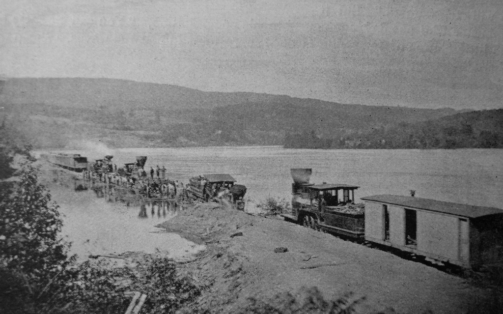
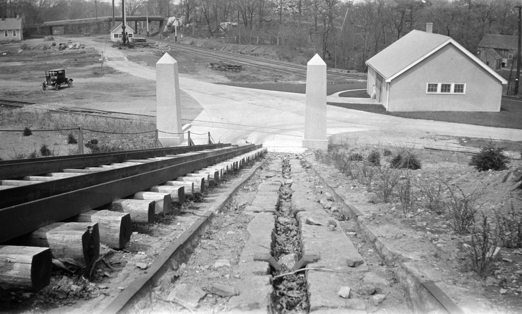
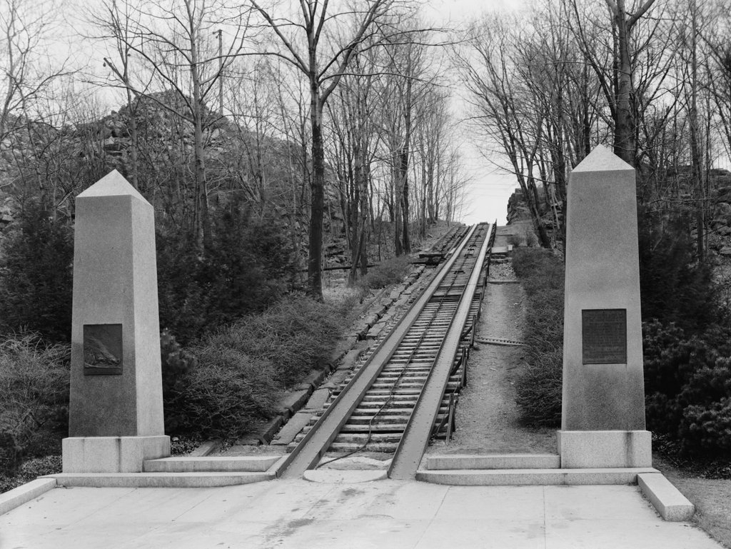
The Granite Railway Incline on Granite Rail Court in Quincy, Massachusetts, in April 1934. Image courtesy of the Library of Congress, Historic American Buildings Survey Collection.
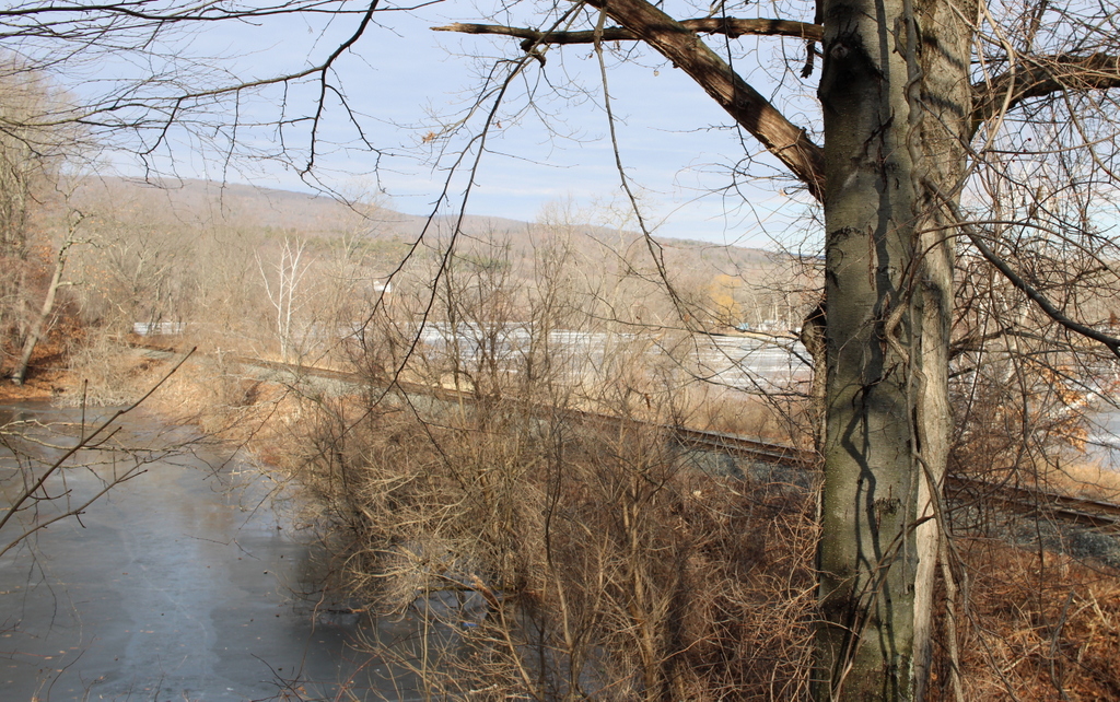
The scene in 2021:

These two photos show the Granite Railway Incline, an important civil engineering landmark from the early days of railroads. It opened in 1830 as a branch of the Granite Railway, a 3-mile-long horse-drawn railroad that is often regarded as the first commercial railroad in the United States. The railroad itself had been established four years earlier, in 1826, for the purpose of supplying granite for the construction of the Bunker Hill Monument. The original 1826 route of the railroad extended about three miles from the Quincy quarries to the wharves on the Neponset River, and from there the quarried stone was transported by boat to Charlestown.

Prior to its construction, there had been a few small railroads in Britain and the United States, and there were even some early steam locomotives that had been developed, but the long-term viability of railroads was still very much uncertain in 1826. The Erie Canal had been completed just a year earlier, and many Americans viewed long-distance canals as the future of transportation. Nonetheless, the engineer for this project, Gridley Bryant, set out to build a horse-drawn railroad. And, because railroad technology was still in its infancy, he had to essentially design it from scratch. As a result, he is credited with developing turntables and switches, among other railroad innovations. He also had to design his own rails, which were made of wood and topped with iron straps except for at road crossings, where the rails were granite and iron.

The Granite Railway opened on October 7, 1826, and over the next few years it overcame skepticism as it steadily delivered cut granite blocks to the wharves on the river. Then, in 1830 Bryant expanded the railroad with a short branch that connected it to the Pine Hill Quarry. Because of the elevation change, this involved constructing a large inclined plane up to the quarry, as shown here in these two photos. In total, it was 315 feet long, and rose 84 feet in elevation, for an average grade of nearly 27%. This is significantly steeper than a conventional railroad, and by way of comparison it is even stepper than the average grade of the Mount Washington Cog Railway, although obviously much shorter. And, because of the need for durable materials here on the slope, Bryant constructed it of granite rails with iron straps, rather than the wooden rails that were used on most of the other sections of track on the railroad.

The inclined plane was built with two parallel sets of track, one for ascending cars and one for descending ones. In the center of each track was a chain that ran on pulleys. It formed a continuous loop up and down the inclined plane, pulling the empty cars up the hill while also controlling the descent of the fully-loaded cars that were leaving the quarry. Bryant later described the operation of the inclined plane in a letter that he wrote in 1859 to Charles B. Stuart:

It had an endless chain, to which the cars were attached in ascending or descending; at the head of this inclined plane I constructed a swing platform to receive the loaded cars as they came from the quarry. This platform was balanced by weights, and had gearing attached to it in such a manner that it would always return (after having dumped) to a horizontal position, being firmly supported on the periphery of an eccentric cam. When the cars were out on the platform there was danger of their running entirely over, and I constructed a self-acting guard, that would rise above the surface of the rail upon the platform as it rose from its connection with the inclined plain, or receded out of the way when the loaded car passed on to the track; the weight of the car depressing the platform as it was lowered down.

Overall, it was an important technological innovation, but the inclined plane also became the site of one of the first fatal railroad accidents in American history. This occurred on July 25, 1832, when a group of four visitors ascended an empty car. On the way up, the chain broke, sending the car on an uncontrolled descent. The resulting derailment killed one passenger and seriously injured two others, as described in an article published in the next day’s Boston Evening Transcript:

Yesterday a party of four Gentlemen, boarders at the Tremont House, consisting of Messrs Andrew E. Belknap and John G. Gibson of this city,—Mr Thomas Backus of St Jago de Cuba, and Wm B. Bend of New York, (formerly of Baltimore) rode out to the Quincy Rail-way. Whilst ascending the inclined plane, near the Granite quarry in one of the cars, and when near the summit, the chain parted and the car descended with frightful rapidity.

The force with which it struck the resting place, at the foot of the declivity, was so great that the car and passengers were thrown by the percussion twenty feet into the air, from whence it fell down a precipice of more than thirty feet, amongst the rocks beneath.

Mr Backus was killed instantly. Mr Bend had three ribs broken, and the sinews of a leg parted. Mr Gibson’s head was fractured, jaw broke, and leg broke. Mr Belknap escaped without injury to his bones, but his body is severely bruised.

Messrs Gibson and Bend are at the Railway House, too ill to be removed. Mr Belknap has returned to the city. Mr Backus, we understand, was to be buried this afternoon at Quincy Church. The plane which they were ascending is said to be inclined at angle of nearly forty degrees; and it is supposed that when the car struck, it must have acquired a velocity of sixty miles an hour.

Aside from this accident, the inclined plane appears to have had a good safety record, and it remained in use into the 20th century. The Granite Railway was eventually acquired by the Old Colony Railroad in 1871, and most of the old track was upgraded. However, the inclined plane was too steep to operate steam trains on, so it remained in use in its original configuration until 1901, when modern rails were laid atop the granite track.

It underwent more changes in 1920, when the 1901 rails were removed and replaced by metal channels, which enabled it to be used by trucks. The top photo shows these channels, along with a pair of obelisks that were installed at the base of the inclined plane in 1921 in order to commemorate its role in the early history of railroads.

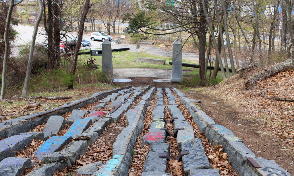
The inclined plane remained in use until the 1940s, but at some point the upper part of it was removed during quarrying operations. As a result, only the lower portion of it still exists, as shown in the bottom photo. The quarry at the top of the hill eventually closed in 1963, and in 1985 the site of the quarry was acquired by the Metropolitan District Commission.

Today, the old quarry and the inclined plane are part of the Quincy Quarries Reservation. Although significantly smaller than it had been when the top photo was taken, the inclined plane is nonetheless the best-preserved remnant of the old Granite Railway. It still features the old granite rails, some of the iron straps atop them, and the old pulleys. Because of its historic significance, the inclined plane was added to the National Register of Historic Places in 1973, and it survives as an important landmark from the early days of railroad development.

Springfield Street Railway Car House, Springfield, Massachusetts (2)

The car house of the Springfield Street Railway, seen from the corner of Main and Bond Streets in Springfield probably in 1892. Image from Picturesque Hampden (1892).

The scene in 2023:

As explained in more detail in the previous post, these two photos show one of the trolley barns that was used by the Springfield Street Railway. The top photo was probably taken right around the same time as the one in the previous post, since both photos show the same shadows in the same positions on the front of the building.

The top photo was taken shortly after the Springfield Street Railway system was electrified in the early 1890s. Prior to this time, the cars rode on rails in the streets but were pulled by horses. The switch to electric trolleys meant that the railway no longer had the expense of keeping several hundred horses, but instead the company needed facilities to store, maintain, and repair trolleys.

The building in the top photo was built sometime around the late 1880s or early 1890s, and it stood on the east side of Main Street between Carew and Bond Streets. The railway also had facilities around the corner on Bond Street and a little to the north of here on Hooker Street, both of which had much larger storage capacities than this one here on Main Street. However, during the mid-1890s this was the only one with pits beneath the tracks, meaning that every car in the system had to be rotated through here on a nightly basis for inspections.

Over time, the railway added new trolley barns, including one on the north side of Carew Street in 1897, along with a new one at Hooker Street in 1916. The old building here on the south side of Carew Street appears to have remained in use into the 20th century, but by the 1930s the trolley lines were steadily being replaced by buses, with the last trolley service ending in 1940.

The 1897 trolley barn on the north side of Carew Street is still standing, and the corner of the building is visible on the far left side of the second photo. However, the earlier trolley barn that is shown in the first photo is long gone. After the demise of the trolleys it was converted into commercial and retail use, and it stood here until December 1971, when it was destroyed by a fire. Its former location is now a gas station, as shown in the second photo.

Springfield Street Railway Car House, Springfield, Massachusetts

The car house of the Springfield Street Railway, seen from the corner of Main and Bond Streets in Springfield, probably in 1892. Image from Picturesque Hampden (1892).

The scene in 2023:

These two photos show the northeast corner of Main and Bond Streets in Springfield. When the first photo was taken, this entire block of Main Street between Bond and Carew Streets was occupied by a Springfield Street Railway car house. Also known as a trolley barn, this building was a storage and maintenance facility for trolley cars. It was one of several car houses that the railway had in the North End, which can make it difficult to trace the history of this specific building, since historical records often made references to car houses or trolley barns without precisely identifying their locations. However, this building appears to have built sometime around the late 1880s or early 1890s, around the same time that the trolley system was electrified.

The Springfield Street Railway opened in 1870, with a single line that ran on Main Street from Hooker Street to State Street, and then east on State Street as far as Oak Street, for a total length of about 2.5 miles. As was the case with other street railways of this era, its cars were pulled along the rails by horses. This had the advantage of reduced friction compared to other horse-drawn vehicles, so a single horse could pull a heavier load while also providing a more comfortable ride for passengers.

The railway proved to be popular, and it was soon expanded with lines into other city neighborhoods. By the early 1880s, the horse-drawn streetcars provided service to Winchester Park (modern-day Mason Square) via State Street, to the Armory Watershops via Maple and Central Streets, and to Mill Street via the southern part of Main Street. The railway stables were originally located at Hooker Street, but those were later supplemented with stables in a building here at the site shown in these two photos, at the southeast corner of Main and Carew Streets. However, it seems unclear whether these stables were later incorporated into the larger building in the first photo, or if the building in the photo was entirely new construction.

Although the railway was successful, it nonetheless had significant operating expenses, particularly the horses. The company eventually required a total of 280 horses for its 74 cars, and the horses outnumbered human employees (156) by almost two to one. However, an alternative emerged in the mid-1880s, with the development of electric streetcars. These cars used electric motors that drew power from overhead wires, and they were often called “trolleys” because the movement of the current collector on the wire resembled that of a fishing boat trolling lines in the water.

The first large-scale electrified streetcar system in the United States was in Richmond, which opened in 1888. The Springfield Street Railway was quick to adopt this new technology, opening its first electrified line from State Street to Sumner Avenue in Forest Park in the summer of 1890. Most other lines soon followed, and the last horse-drawn trolley—which crossed the Old Toll Bridge to West Springfield—was retired in January 1893.

The first photo was taken soon after the system was electrified, and it shows six electric trolleys in front of the car house at the southeast corner of Main and Carew Streets. Like most other early trolleys, these were generally single-truck cars, meaning that they had just one chassis, unlike the larger trolleys of the early 20th century that typically had two trucks. The trolley closest to the camera, on the far right side of the scene, helps to establish the date of the photo. The front reads “Indian Orchard,” and since the Indian Orchard line opened in 1892, the photo likely could not have been taken before then. And, since it was published in a book in 1892, the photo could not have been taken later than that year.

By this point, the company had 32.5 miles of track, with an annual ridership of over 6.3 million. For many, the trolley was a way to commute to work from the suburbs, but it was also popular for recreational excursions, especially to the more distant locations such as Forest Park and Indian Orchard. The network of trolley lines served much of the city, and also connected to the neighboring towns of West Springfield, Chicopee, and Ludlow. The company charged a flat rate fare of five cents per trip on all lines except for Ludlow, which was ten cents.

As with any change, the switch to electric trolleys did raise some issues. For some, there were general concerns about the safety of electric power and the speed of the trolleys, while other concerns focused on more specific operational issues. A September 27, 1891 article in the Springfield Republican identified some of these, including confusing schedules. A schedule for one of the lines was reprinted in the article, and it read:

State street cars leave corner Main and Carew streets for Boston road at 5.50, 6.10, 6.30, 6.50, 7.10, 7.30, 7.50, 8.10, 8.30, 8.50, 9.10 a.m. From 9:23 a.m. until 4.18 p.m. every 15 minutes. From 4.18 p.m. until 7.18 p.m., every 12 minutes. From 7.23 p.m. until 10.38 p.m., inclusive, every 15 minutes.

Such a schedule gives a good sense of the interval between cars, but it makes it more complicated to determine exact departure times, since that requires adding or subtracting increments of 12 or 15 minutes to or from the specified times. And, although not specifically mentioned in the article, the math doesn’t quite add up; the cars were supposed to leave every 15 minutes from 9:23 to 4:18, yet that timeframe is not evenly divisible by 15 minutes.

Aside from the complicated schedule, the article also explained how, in many cases, the trolleys did not consistently keep to this schedule. Several different routes, including the State Street one, originated here at the corner of Main and Carew, presumably here in this building. However, there was not always a supervisor on hand to ensure that they departed at the correct time. As explained in the article:

Some people assert that the cars are not started properly on their trips. The assistant superintendent says that he acts as car-starter, but admits that he is away from the barn a good share of the time, when, so far as his personal avowal goes, the cars take care of themselves. The transfer man, who sits on the sidewalk at the corner of Main and Carew streets and tells the conductors who have paid among the passengers, and who haven’t, says he sees the cars do not get off late, but as he never uses his watch, it is to be inferred the cars are never behind hand.

In many cases, the issue seems to have been that the cars were leaving too early, combined with the fact that the trolleys were generally able to make their trips in less time than the scheduled times. This meant that passengers who successfully deciphered the schedule and arrived at the appointed time would often discover that the trolley had left several minutes earlier. The article described how:

Now, if the conductors will only hold their cars until plump on the advertised leaving time the mechanics and wood-workers around Winchester park will be greatly pleased, for, according to these men’s testimony, the car supposed until recently to leave the upper end at 6:06 p.m. had a troublesome habit of getting off from one to three minutes early, so that the workmen are obliged to ride smutty, or hustle amazingly.

Overall, most of the issues raised in the article seemed to be relatively minor inconveniences, rather than serious safety issues. As the article observed, “[w]ith the perfection and speed and extra comfort in open cars and cushioned seats the public has grown even more exacting.” And, because it is impossible to keep everyone happy, there were simultaneously complains that the cars ran too fast and that they ran too slow; that they rang their bells too much, or not enough; and that the open cars were too cold, while the closed cars were too stuffy. The article also pointed out, rather facetiously, that “[s]ome people want the cars to run right up to their doors, and would like the conductors to carry them in, while others think it an infringement on constitutional rights if the tracks are laid through their streets.”

In the meantime, the trolley system continued to expand with new lines throughout the 1890s, reaching about 40 miles of track by 1895. All of this required a considerable amount of maintenance in order to ensure that the tracks, the overhead wires, and the trolley cars themselves were all in good condition. Much of this work occurred here in the car houses, including the one shown here in this photo. Another Springfield Republicans article, published on December 29, 1895, provided an overview of how the system was maintained, including a detailed description of the regular work that was done on the trolleys:

The company has made a practice of putting every car into the shops once every year, when it is taken all to pieces, the mechanical and electrical parts thoroughly inspected and repaired and put together as good as new. The closed cars are overhauled in the summer and the open cars in the winter and they are painted if necessary. Then there is the daily inspection. Certain men have certain cars for whose condition they are responsible. They examine their cars carefully every day and make a daily report. One man is made responsible for all the cars and he receives those reports and takes charge of the repairs. When a car is out of repair a sign “Off” is hung up on it, and if the break is serious it is sent to the shop; if not the repairs are made in the barn. The car inspectors are men who are thoroughly up in mechanical and electrical matters. When a car comes into the barn for the night there are but a few hours before it goes into use again and during these few night hours the inspectors are busy. They raise the trap doors in the floor of the car and look over the motors carefully, examining the armatures, all the wire connections, the brushes and everything else that is at all likely to get out of order. Then they go down under the car and make an equally careful observation from the outside. If you have been in the car barns you have noticed the open spaces over which the cars run. These enable the inspector to examine with grate minuteness any part of the apparatus.

The brake is the thing that is examined with the most care, for the brake has to be relied upon to save lives and property, and it is essential that it be in a state of perfection. Outside of the regular inspection of the car there is a special inspection of the brakes. One man has charge of this and he is a high-priced man. It is his duty to look at every brake each day, or rather night, for he has to make examinations while the stars shine, and once a week every car is thoroughly tested in every respect. This man has to show in writing that every car has been tested. Besides all these examinations, the machinery of the car is constantly under the observation of the motorman and conductor, who acquire a considerable knowledge of the mechanism, and there is always a man stationed at Court Square or the corner of State street to see that everything is going right. It is astonishing how quickly a difficulty can be placed. An inspector can tell from the sound of a motor not only what make it is, but whether it is in good repair. In examining the machinery they get so familiar with it that they recognize each motor as an old acquaintance. Sometimes the motors are changed about in the cars and an inspector can tell you what car a certain motor came out of.

By 1897, about five years after the first photo was taken, the railway had about 180 cars—including snowplows—that all had to be stored and maintained on a regular basis. There were three main facilities here in the North End, including the car house here on Main Street, another one nearby on the south side of Bond Street, and one on Hooker Street. According to a May 29, 1897 article in the Republican, the railway was outgrowing these car houses, which often meant that around 10 to 12 trolleys were left outdoors overnight.

At the time, the Bond Street facility had a capacity of about 75 trolleys, while Hooker Street could store about 50. Here at the Main Street car house, there was only room for about 25 cars. But, the article also noted that this was the only facility with pits below the tracks. Because part of the daily inspections involved examining beneath the trolleys, this meant that each trolley had to come through this building every night, before ultimately being moved to its overnight storage building.

This overcrowding prompted the railway to acquire more land for a new facility. In 1897, the company purchased the former Carew house, located just to the north of here on the other side of Carew Street. This house, which is partially visible in the distance behind the left-most trolley in the first photo, had been built in 1803 as the home of Joseph Carew Sr. It would remain in his family for almost a century, with his daughter Caroline Spencer living here until her death in 1895 at the age of 84. During that time, she saw her neighborhood transform from a sparsely-populated area on the outskirts of a small town, into the transit hub of a rapidly-growing city. Her death marked the end of an era here, and the house was demolished after it was purchased by the railway. In its place, the company built a new car house, which still stands today at the northeast corner of Main and Carew Streets, on the left side of the second photo.

The early 20th century would prove to be the heyday of trolleys, both in America and also here in Springfield. The book Springfield Present and Prospective, published in 1905, gave description of the street railway system, which by that point had expanded to almost 94 miles. The fleet consisted of 107 closed cars and 120 open cars, and on a typical day a total of 75 of these cars were needed in order to maintain the schedules. And, beyond just linking the suburbs to the city center, the railway had also expanded to include service between other cities in the area. The book explains how, from Springfield, trolley passengers could travel to Holyoke, Northampton, Westfield, Palmer, and Hartford without even having to make any transfers.

In 1916 the trolley system was further supported by another car house, which opened a few blocks to the north of here at the corner of Main and Hooker Streets. However, by this point automobiles were becoming affordable to middle class families, and this trend would continue into the 1920s, making public transportation less of a necessity for many people. At the same time, trolley lines around the country were steadily being replaced by buses. This was the case here in Springfield, with trolley service eventually being whittled down to just the Forest Park line. This had been the first electrified line in the system, and it would prove to be the last, with the final trolley concluding its last run— with much fanfare—in the early morning hours of June 23, 1940.

The Springfield Street Railway continued to operate under this name for many years, despite being a “railway” in name only, with buses having replaced all of the former trolley lines. It eventually merged to form the Pioneer Valley Transit Authority, which continues to provide bus service to Springfield and the other communities in the region.

Two of the former trolley barns still exist today. The one at Hooker Street is now used as a bus garage, and the one at the northeast corner of Main and Carew has been converted to other commercial uses. It is visible in the distance on the left side of the second photo, and it remains a distinctive landmark in the North End.

As for the trolley barn in the top photo, it was later converted into commercial and retail use. It stood here until it was destroyed by a fire in December 1971. The site of the building is now a gas station, and the contrast between these two photos provides a vivid illustration of the old trolleys and the newer method of transportation that replaced them.

Carrollton Viaduct, Baltimore, Maryland

The Carrollton Viaduct over Gwynns Falls in Baltimore, around 1921. Image from the October 1921 issue of the Baltimore and Ohio Employees Magazine.

The scene in 2021:

These two photos show the view of the Carrollton Viaduct from the east, where it passes over the Gwynns Falls stream. This bridge is a significant civil engineering landmark, as it was the first masonry arch railroad bridge in the United States, and today it remains in use as the country’s oldest active railroad bridge.

The bridge was constructed by the Baltimore and Ohio Railroad, which, depending on the criteria used, is often regarded as the first railroad in the United States. Prior to the 1830s, the primary means of inland transportation in the United States were turnpikes and canals. However, investors in Baltimore saw the potential of the newly-emerging railroad technology, and in 1827 they organized the Baltimore and Ohio Rail Road Company. This was not necessarily the first railroad in the country, as there were much smaller ones that predated it, but this was a far more ambitious plan, to construct a railroad westward from Baltimore, through the Appalachians, and to the Ohio River.

It would take many years before that goal would be completed, but in the meantime the railroad made significant progress here in the vicinity of Baltimore. Work on the railroad began on July 4, 1828, with a ceremony that featured Charles Carroll laying the cornerstone. Sources seem unclear as to whether that cornerstone was specifically for this bridge, or if it was at a different part of the railroad line, but either way it was a highly symbolic event. Carroll, aged 90, was the last living signer of the Declaration of Independence, so his presence provided an important link between the country’s founding principles and its new visions of industry and technological improvements.

Regardless of where the actual cornerstone ceremony occurred, this bridge would be one of the first of many engineering challenges that the new railroad would face as it worked its way westward from Baltimore. Here, the railroad had to cross over Gwynns Falls, a stream that was flanked on both sides by high embankments. Railroad superintendent Casper Wever was tasked with designing the bridge, and his initial plans called for a single 50-foot arch over the stream. However, because of concerns about flooding, this was changed to an 80-foot arch over the stream, along with a smaller 16-foot arch over a road that ran parallel to the stream on the left side of this scene.

In the end, the finished bridge was 312 feet long, and it rose 51 feet, 9 inches above the water. The work was completed in the fall of 1829, and it opened on December 21, 1829, in another ceremony that was attended by Charles Carroll. This time, he laid the final stone of the parapet, and the bridge was formally named the Carrollton Viaduct in his honor. The Baltimore Gazette And Daily Advertiser, reporting on the event the next day, provided the following account:

The Bridge over Gwynn’s Fall’s was yesterday completed by the laying of the last stone on the Eastern extremity of the South parapet. Carroll of Carrollton, our venerated fellow citizen, the last living signer of the Declaration of Independence, presided at the ceremony, and the Bridge, in pursuance of a resolution of the Board of Managers, was named after him—”The Carrollton Viaduct.” In the short & very appropriate address of Mr. Lloyd, the builder of the Bridge, to Mr. Carroll, he says that he does not ask for it a longer duration than the same of the last surviving signer; and we have no doubt that the Bridge will be found uninjured by time so long as the rocks upon which it is based shall stand. It speaks the character of the great work whose commencement it ornaments—firm as beautiful—useful as enduring.

As it turned out, Lloyd’s modest hope that his bridge would enjoy the same longevity as its namesake proved to be a considerable understatement. At the time, Carroll was 92 years old, and the first photo in this post was coincidentally taken about 92 years after the bridge was completed. By this point, the bridge was still going strong after nearly a century, even as rail traffic over the bridge had evolved from small horse-drawn trains of the 1820s, to the large steam locomotives and heavy freight cars of the 1920s.

Today, another century has gone by since the first photo was taken. The Baltimore and Ohio Railroad no longer exists, having been absorbed by other companies in a series of mergers. However, this line is still an active railroad operated by CSX Transportation, and the nearly 200-year-old stone bridge still carries modern rail traffic over Gwynns Falls. Because of its pioneering role in the early years of railroad development in the United States, the bridge was designated as a National Historic Landmark in 1971, and in 1982 it was similarly named a National Historic Civil Engineering Landmark.

Burnside Bridge, Sharpsburg, Maryland (2)

The view of the north side of the Burnside Bridge, from the west bank of Antietam Creek, in September 1862. Photographed by Alexander Gardner. Image courtesy of the Library of Congress, Civil War Glass Negatives and Related Prints collection.

The scene in 2021:

As explained in more detail in the previous post, the Burnside Bridge—or lower bridge, as it had previously been known—was the focal point of the later phase of the Battle of Antietam on September 17, 1862. Ahead of the battle, the Confederates under Robert E. Lee had taken a defensive position near the town of Sharpsburg, with a line of soldiers that extended north to south. The southern end of his line was anchored on the heights just to the west of this bridge, and this led to intense fighting for control over the bridge.

Opposing the Confederates in the vicinity of the bridge was General Ambrose Burnside, whose IX Corps was positioned to the east of here, in the distance on the left side of this scene. However, because of poor coordination on the part of the Union commander, General George B. McClellan, Burnside received no orders until around 10:00 a.m., long after the fighting had begun on the northern part of the battlefield.

Despite the bridge being defended by only 500 Confederate soldiers, it took Burnside’s 4,000-man corps several hours to take the bridge, suffering about 500 casualties in the process. The Union forces finally took the bridge around 1:00 p.m., but Burnside delayed in moving his men, and they did not all cross until around 3:00 p.m. This gave the Confederates time to gather reinforcements, and rather than striking a decisive blow at the Confederate line, Burnside’s soldiers were faced with fresh Confederate soldiers commanded by A. P. Hill. The final portion of the battle occurred on the heights to the west of the bridge, to the right of where these photos were taken, and it was largely inconclusive, with Burnside’s soldiers managing to hold the bridge but unable to gain much ground.

The bridge came to be known as Burnside Bridge in his honor, although his actions here did face criticism. Some criticized his delays in moving his corps over the bridge, while others questioned whether the Union could have simply waded across the shallow creek, rather than making a costly and time-consuming effort to seize the bridge. Nonetheless, he was subsequently promoted to command of the Army of the Potomac in November, but he was ultimately dismissed after the disastrous Battle of Fredericksburg, which likewise involved a time-consuming crossing of a waterway.

The first photo was taken only days after the battle, by prominent Civil War photographer Alexander Gardner. Today, not much has changed here in this scene. The bridge is still standing, as is one of the trees from the first photo. Barely noticeable on the far left side of the first photo is a small sycamore tree, which now towers over the bridge in the present-day scene. It is the most famous “witness tree” at Antietam, and both the tree and the bridge itself are major landmarks here at the Antietam National Battlefield.