Dunker Church, Sharpsburg, Maryland

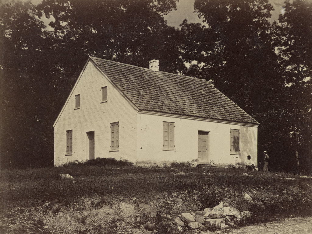
The Dunker Church near Sharpsburg, Maryland, around 1862-1865. Photo by James Gardner, courtesy of the Library of Congress, Civil War Glass Negatives and Related Prints collection.

The church in 2021:

The first photo was taken by James Gardner, and it was published in 1865 in his brother Alexander’s Photographic Sketch Book of the War. It shows the Dunker Church, which had been a major landmark during the Battle of Antietam on September 17, 1862. The original church survived the battle only to be destroyed by a windstorm in 1921, but a replica was later built on the same site, as shown in the present-day scene.

The church was built in 1852 for the German Baptist Brethren, who were also known as the “Dunkers” because of their practice of baptism by immersion. Their beliefs were related to other Anabaptist churches like the Amish and the Mennonites, and one of their core values was pacifism. In light of that, it is particularly ironic that their meeting house here would become a focal point in the bloodiest single-day battle in American history.

The Battle of Antietam was the culmination of the first major Confederate offensive campaign into Union territory. Emboldened by recent victories such as the Second Battle of Bull Run, Robert E. Lee hoped to bring the war to the north. In doing so, one of his goals was to weaken the northern morale and their willingness to fight the war. To that end, Lee marched northwest from Virginia into Maryland. Along the way, he fought battles at Harpers Ferry, South Mountain, and Crampton’s Gap, before ending up in Sharpsburg, Maryland. There, he took a defensive position just outside of the town, with his left flank positioned here in the vicinity of the Dunker Church.

The battle began early in the morning of September 17, with a Union assault on the left flank led by General Joseph Hooker. Because of its visibility on the battlefield and its location in the midst of the Confederate defenses, the church became the focal point of the Union attack. However, despite having a small numerical advantage, Union soldiers made little progress in their advance, leading to a particularly bloody scene in a corn field about a half mile to the north of the church, where both sides suffered heavy casualties.

Reflecting on the events of the battle, Confederate General Thomas “Stonewall” Jackson described the scene here, writing:

The carnage on both sides was terrific. The hottest fight seemed to center about Dunker Church, where there were no less than four charges and counter-charges. Each army had taken and retaken the ground until it was literally carpeted with dead and dying men.

Over the course of the morning, the battle shifted away from the church. Much of the fighting in the middle stages of the battle centered around the “sunken road” to the southeast of the church, and later in the day the fighting was even further south, in the vicinity of Burnside’s Bridge. Throughout this, neither side made significant progress. The fighting was over by early evening, leaving over 2,000 Union soldiers dead and nearly 10,000 wounded, compared to 1,500 Confederates killed and over 7,700 wounded.

Although both sides suffered similar losses, the Battle of Antietam is generally regarded as an important strategic victory for the Union. In the aftermath of the battle, General Lee abandoned his attempts to invade the north, and instead brought his army back to Virginia. He would eventually attempt one more large-scale invasion of the north less than a year later, but he suffered an even more decisive loss at Gettysburg in July 1863.

In the meantime, the Dunker Church sustained significant damage during the battle, from bullets as well as artillery fire. Photographs taken in the immediate aftermath show a number of holes in the roof and in the brick walls. However, this damage was soon repaired, and the church was back in use by 1864. The first photo was taken about a year later, showing the exterior of the repaired building. The photo was taken by James Gardner, the younger brother of prominent Civil War photographer Alexander Gardner, and it was published in Gardner’s Photographic Sketchbook of the War after the end of the war.

Following the war, the church continued to be one of the most important symbols of the battle, but it also continued to be used as a church until 1899, when the congregation moved to a new building. Now vacant, the old building deteriorated over the next few decades, assisted by souvenir hunters who helped themselves to bricks from the walls. In the end, the humble brick church that had survived one of the deadliest battles of the Civil War was destroyed by a windstorm in 1921.

The site of the church later became a gas station, lunch counter, and souvenir stand, but in 1951 the property was purchased by the Washington County Historical Society and then transferred to the National Park Service. It became part of the Antietam National Battlefield, and in 1962 the church was reconstructed on the original foundation as part of the centennial of the battle.

Today, despite the church being a modern reconstruction with very little original material, this scene still has largely the same appearance as it had in the 1860s. Antietam is one of the best-preserved Civil War battlefields, and the reconstructed church remains one of its most distinctive landmarks. The building is open to the public, and its design is based on what the interior of the original church would have looked like in 1862.

Maryland Heights from Harpers Ferry, West Virginia

Looking across the Potomac River toward Maryland from Harpers Ferry, around 1859. Image courtesy of the Library of Congress, Civil War Collection.

729_1859c loc

The scene in 2015:

729_2015 loc
Assuming the estimated date is correct, the first photo was probably taken within a few months before or after John Brown’s raid on the Harpers Ferry Armory.  It shows the view from the Armory looking across the Potomac River toward Maryland Heights, with the Baltimore & Ohio Railroad bridge to the right.  The Chesapeake & Ohio Canal also ran through this scene; the buildings across the river were built on either side of Lock 33.

Within a few years, much of this scene would change.  Harpers Ferry changed hands many times during the war, and during one of their retreats the Confederate forces burned the bridge, as seen in the 1861 photo in the previous post, which was taken from the opposite side of the river.  The bridge has since been replaced several times, and the current one can be seen on the far right, a little upstream of the original one.

The Chesapeake & Ohio Canal survived the war, and despite increased competition from railroads it remained in operation until 1924.  Today, the stone remains of Lock 33 are still standing, hidden from this view by the railroad bridge and the trees along the river.  All of the buildings have long since disappeared, though, except for one: the two story stone house right up against the cliff on the left side of the photo.  It was built in the winter of 1840-1841, and survived John Brown’s raid, the Civil War, and a number of floods before being gutted by a fire in the 1960s. The stone walls are still standing, though, and it is now part of the Harpers Ferry National Historical Park.

One historical curiosity in the second photo is the advertisement painted on the rocks near the center of the photo.  It reads “Mennen’s Borated Talcum Toilet Powder,” and it was painted in 1906 for railroad passengers as they traveled through here.  Although not as distinct as it once was, the controversial advertisement is still there, despite efforts in the 1960s to remove it using paint remover and carbon black.

Harpers Ferry, West Virginia

Looking across the Potomac River towards Harpers Ferry from the Maryland side of the river, around June 14, 1861. Image courtesy of the Library of Congress, Civil War Collection.

728_1861 loc

The same view in 2015:

728_2015 loc
The town of Harpers Ferry had only about 1,300 residents at the start of the Civil War, and its land area was just a half a square mile, but it became among the most contested places of the war.  It was literally located on the border of the Union and the Confederacy, changing hands eight times during the war and ending up in a different state by the time it was over.

As its name implies, this area was first settled as a ferry crossing.  Originally part of Virginia, it is located at the confluence of the Potomac and Shenandoah Rivers, and beginning in 1733 colonist Peter Stevens operated a ferry across the Potomac here, enabling settlers from Maryland and Pennsylvania to access the Shenandoah Valley of Virginia.  The town isn’t named Stevens Ferry, though, because around 1748 he sold his land and ferry to Robert Harper, who operated it until his death in 1782.

Because of its transportation connections and relatively defensible position, Harpers Ferry was one of two locations, along with Springfield, Massachusetts, selected by George Washington for federal armories.  Further transportation developments came in the 1830s: the Chesapeake & Ohio Canal (seen in the lower foreground of both photos) was completed as far as Harpers Ferry in 1833, several stagecoach lines were opened in 1834, and the Baltimore & Ohio Railroad reached the Maryland (foreground) side of the river later in 1834.  The first railroad bridge was completed in 1837, allowing a direct connection from the armory to the rapidly growing national rail network.

By 1850, this small town had grown to over 1,700 people thanks to the armory (visible along the waterfront to the right in the first photo), but before the end of the decade it would become the center of one of the major precursors to the Civil War.  In October 1859, abolitionist John Brown led a raiding party of 22 men in an attempt to capture the arsenal and start a slave rebellion.  The raid ultimately failed, and most of the raiders were either killed or were captured and executed, including John Brown, whose December 2 execution was seen as a martyrdom by many northern abolitionists.

The Civil War began just a year and a half after the raid, and Virginia’s state legislators voted to secede on April 17, 1861.  One of the state’s first objectives was to take the Harpers Ferry arsenal, which at the time was guarded by just 65 men.  Led by Lieutenant Roger Jones, they destroyed the arsenal and its 15,000 guns before evacuating the town ahead of the Confederates.  The Confederates didn’t occupy the town for long, though.  They left on June 14, and burned the Baltimore & Ohio bridge as they left.  The remains of the bridge can be seen in the foreground of the first photo, which according to the caption was “photographed immediately after its evacuation by the rebels.”

When the first photo was taken, the town was still relatively intact, but as the war progressed it became somewhat of a no man’s land.  Despite the loss of the armory, it was still a vital transportation corridor for armies on both sides, so between 1861 and 1863 it changed hands several more times.  West Virginia became a state on June 20, 1863, with Harpers Ferry citizens voting 196 to 1 to leave Virginia and join the union.  The town was briefly occupied by the Confederates in early July, but they soon evacuated for the last time and Union solders returned on July 13, finally bringing stability to Harpers Ferry for the rest of the war.

In terms of population, Harpers Ferry never fully recovered from the Civil War.  The armory never reopened, and the population has steadily fallen to less than 300 as of the 2015 census.  However, it has become a major tourist destination, with the Harpers Ferry National Historic Park now comprising much of the historic town.  Although the Chesapeake & Ohio Canal has not operated in nearly a century, there are still several railroad lines that pass through here.

One of the bridges, seen to the right in the 2015 photo, also carries the Appalachian Trail over the Potomac River on a pedestrian walkway on the left side of the bridge.  The bridge pier in the foreground is from an earlier railroad bridge that had been built on the spot of the one that was destroyed in 1861.  This bridge, in turn, was washed away in a 1936 flood, and it was never rebuilt.  Today, the modern railroad bridge, as well as trees along the river, help to hide the view of Harpers Ferry, with only a few buildings visible in the 2015 scene.

(Much of the information for this post came from “To Preserve the Evidences of a Noble Past”: An Administrative History of Harpers Ferry National Historical Park (2004).  For further reading, it and other resources are available online here at the National Park Service website.)