Ezekiel Keith House, Springfield, Massachusetts

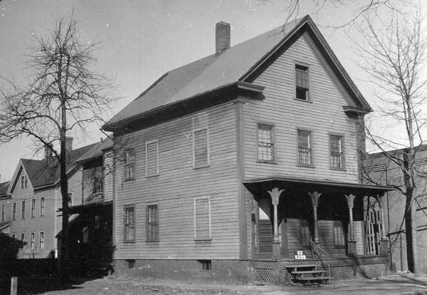
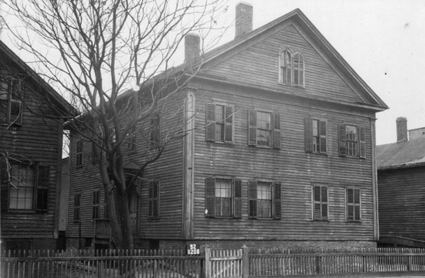
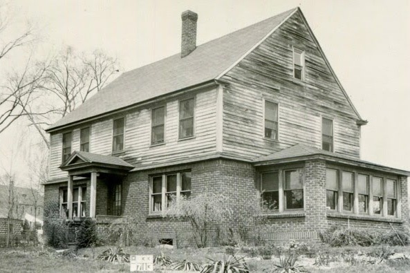
The house at 258 Mill Street in Springfield, around 1938-1939. Image courtesy of the Springfield Preservation Trust.
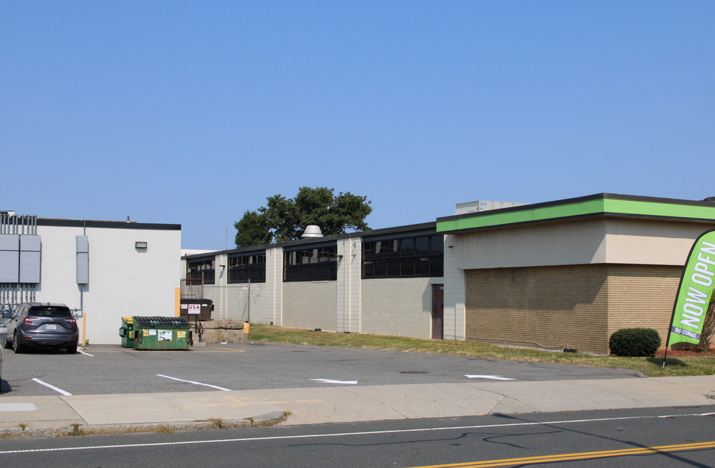
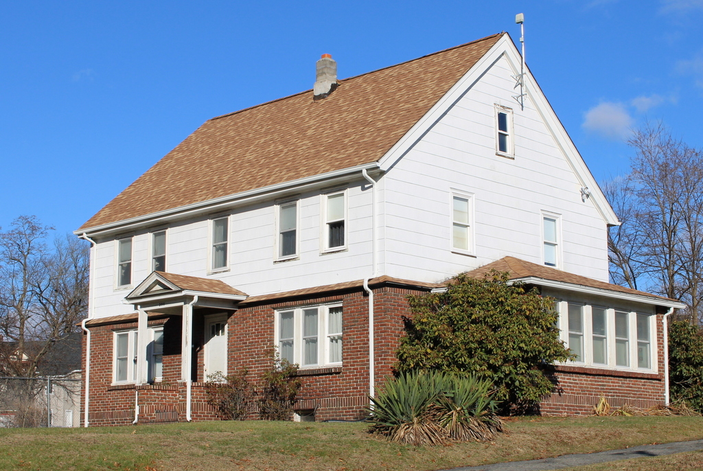
The house in 2023:

Springfield was established by colonial settlers in 1636, making it by far the oldest community in Western Massachusetts. However, unlike nearly all of the other cities and towns in the area, it does not have any surviving buildings that have been verifiably traced back to the colonial period. Most of the colonial-era houses in Springfield were demolished during a period of rapid population growth in the late 19th and early 20th centuries, and today there are only a few dozen buildings that predate 1850, with none that can be confidently dated prior to 1800.

Despite this apparent lack of early buildings, many of the older houses in Springfield have not yet been extensively researched, so it is possible that there might be at least a few 18th century homes still standing in the city. Most of the prominent colonial-era homes in Springfield were located along the Main Street corridor, which was heavily developed and redeveloped many times over the course of the 19th, 20th, and 21st centuries. As a result, there are clearly no 18th century buildings still standing in the downtown area, but it is possible that some might still exist in the outlying areas, which experienced less development pressure over the years, and where individual buildings were not necessarily as well documented by past historians, who tended to focus on the downtown area.

There are several houses in particular that warrant further research, but perhaps the single strongest contender for the title of oldest building in the city is the house shown in these two photos, which stands at the northeast corner of Mill and Knox Streets. The early history of this house has not yet been fully traced, and the interior architecture does not appear to have been studied yet, but the exterior appearance of the house seems to suggest that it was constructed at some point in the second half of the 18th century. Important clues include the spacing of the windows, the steep roof, and the slightly overhanging second story, all of which were typical for houses of that period.

The earliest documented owner of this house is Ezekiel Keith, who was shown as living here on the 1835 map of Springfield. Keith was born in Canton, Massachusetts around 1778, but he was in Springfield by 1806 when he married Elizabeth Ashley. It is possible that this house was built around the time that they were married, but based on its architecture it seems more likely that it was built a few decades earlier.

The house remained in the Keith family throughout the first half of the 19th century. Elizabeth died in 1825, and four years later Ezekiel remarried to Mary Barber. He died in 1846, but Mary outlived him by many years and apparently lived in this house until her death in 1873.

During their many decades of ownership here, the Keith family would have seen many significant changes to the surrounding area. The house is located on a hill just a few hundred feet to the north of the Mill River, near where the modern-day Mill Street crosses the river. Ezekiel’ death records indicate that he had been a farmer, so it seems unclear as to whether he was involved in any of the manufacturing that occurred along the river, but during the first half of the 19th century this section of the river developed into an important industrial center.

The Mill River is the only major source of water power that is entirely in Springfield, so a number of factories were built along its banks, including the Armory Watershops, where much of the heavy manufacturing for the U.S. Armory occurred. The Watershops were originally located on three separate sites along the river, including the Middle Watershops, which were just a little further upstream from the Keith house. Downstream of the house, on the other side of Mill Street, were the Ames Paper Mills, which had been established by former Armory superintendent David Ames.

Census records prior to 1850 do not provide much information about exactly who was living in a particular house, but starting in 1850 the census recorded the names and demographic information of every household member. Here in this house, Mary Keith was living here with a large family. Two adult children from her first marriage, John Barber and Lucia Alden, lived here, as did her stepdaughter Olive Keith. The household also included Lucia’s husband Elijah Alden, and their children Lucia, Louisa, and Joel. Elijah worked as a carpenter, while John Barber was listed as being a gunsmith, probably at the nearby Armory Watershops.

After Mary’s death in 1873, her son John continued to live here. The 1880 census shows him here with his wife Harriet and a boarder, Dr. James W. Wicker. It seems unclear as to exactly what Dr. Wicker’s relationship to the Barbers was, but John died in 1887 and three years later Dr. Wicker married Harriet. He died in 1908, and Harriet died in 1916, ending about a century of ownership by the Keith/Barber families.

The house was subsequently owned by Walter and Otillie Cowles. They were living here by about 1918, and they initially rented the house before purchasing it in the early 1920s. During the 1920 census they were both in their early 40s, and they had five children: Augusta, Walter, Norman, Charles, and Irving. The elder Walter worked as a tile setter, while his 18-year-old son Walter was listed as a “tile helper,” presumably working with with his father. Their daughter Augusta was also employed, working as a machine operator in a toy factory.

The Cowles family was still living here when the top photo was taken in the late 1930s. By this point the house had undergone some exterior changes, likely after the Cowles family purchased it. These changes included a portico at the front entrance, a small addition on the right side of the house, and the installation of brick veneer on the first floor. Given Walter’s occupation as a tile setter, it seems plausible that he would have done the brickwork himself.

At some point the house was further altered by installing artificial siding on the upper parts of the house. This may have also occurred during the Cowles family’s ownership. Walter and Otillie lived here until their deaths in the 1960s, and the house remained in the family until 1990, when it was finally sold by Walter’s estate.

Today, the house is still easily recognizable from the first photo, and even the saw palmettos in the foreground appear to be some of the same ones that were here in the 1930s. At first glance, the age of this house is somewhat difficult to tell, since the exterior is entirely covered in 20th century materials. However, it is definitely one of the oldest surviving buildings in the city, and depending on its exact construction date it might be the city’s only surviving colonial-era building.

Springfield Street Railway Car House, Springfield, Massachusetts (2)

The car house of the Springfield Street Railway, seen from the corner of Main and Bond Streets in Springfield probably in 1892. Image from Picturesque Hampden (1892).

The scene in 2023:

As explained in more detail in the previous post, these two photos show one of the trolley barns that was used by the Springfield Street Railway. The top photo was probably taken right around the same time as the one in the previous post, since both photos show the same shadows in the same positions on the front of the building.

The top photo was taken shortly after the Springfield Street Railway system was electrified in the early 1890s. Prior to this time, the cars rode on rails in the streets but were pulled by horses. The switch to electric trolleys meant that the railway no longer had the expense of keeping several hundred horses, but instead the company needed facilities to store, maintain, and repair trolleys.

The building in the top photo was built sometime around the late 1880s or early 1890s, and it stood on the east side of Main Street between Carew and Bond Streets. The railway also had facilities around the corner on Bond Street and a little to the north of here on Hooker Street, both of which had much larger storage capacities than this one here on Main Street. However, during the mid-1890s this was the only one with pits beneath the tracks, meaning that every car in the system had to be rotated through here on a nightly basis for inspections.

Over time, the railway added new trolley barns, including one on the north side of Carew Street in 1897, along with a new one at Hooker Street in 1916. The old building here on the south side of Carew Street appears to have remained in use into the 20th century, but by the 1930s the trolley lines were steadily being replaced by buses, with the last trolley service ending in 1940.

The 1897 trolley barn on the north side of Carew Street is still standing, and the corner of the building is visible on the far left side of the second photo. However, the earlier trolley barn that is shown in the first photo is long gone. After the demise of the trolleys it was converted into commercial and retail use, and it stood here until December 1971, when it was destroyed by a fire. Its former location is now a gas station, as shown in the second photo.

Springfield Street Railway Car House, Springfield, Massachusetts

The car house of the Springfield Street Railway, seen from the corner of Main and Bond Streets in Springfield, probably in 1892. Image from Picturesque Hampden (1892).

The scene in 2023:

These two photos show the northeast corner of Main and Bond Streets in Springfield. When the first photo was taken, this entire block of Main Street between Bond and Carew Streets was occupied by a Springfield Street Railway car house. Also known as a trolley barn, this building was a storage and maintenance facility for trolley cars. It was one of several car houses that the railway had in the North End, which can make it difficult to trace the history of this specific building, since historical records often made references to car houses or trolley barns without precisely identifying their locations. However, this building appears to have built sometime around the late 1880s or early 1890s, around the same time that the trolley system was electrified.

The Springfield Street Railway opened in 1870, with a single line that ran on Main Street from Hooker Street to State Street, and then east on State Street as far as Oak Street, for a total length of about 2.5 miles. As was the case with other street railways of this era, its cars were pulled along the rails by horses. This had the advantage of reduced friction compared to other horse-drawn vehicles, so a single horse could pull a heavier load while also providing a more comfortable ride for passengers.

The railway proved to be popular, and it was soon expanded with lines into other city neighborhoods. By the early 1880s, the horse-drawn streetcars provided service to Winchester Park (modern-day Mason Square) via State Street, to the Armory Watershops via Maple and Central Streets, and to Mill Street via the southern part of Main Street. The railway stables were originally located at Hooker Street, but those were later supplemented with stables in a building here at the site shown in these two photos, at the southeast corner of Main and Carew Streets. However, it seems unclear whether these stables were later incorporated into the larger building in the first photo, or if the building in the photo was entirely new construction.

Although the railway was successful, it nonetheless had significant operating expenses, particularly the horses. The company eventually required a total of 280 horses for its 74 cars, and the horses outnumbered human employees (156) by almost two to one. However, an alternative emerged in the mid-1880s, with the development of electric streetcars. These cars used electric motors that drew power from overhead wires, and they were often called “trolleys” because the movement of the current collector on the wire resembled that of a fishing boat trolling lines in the water.

The first large-scale electrified streetcar system in the United States was in Richmond, which opened in 1888. The Springfield Street Railway was quick to adopt this new technology, opening its first electrified line from State Street to Sumner Avenue in Forest Park in the summer of 1890. Most other lines soon followed, and the last horse-drawn trolley—which crossed the Old Toll Bridge to West Springfield—was retired in January 1893.

The first photo was taken soon after the system was electrified, and it shows six electric trolleys in front of the car house at the southeast corner of Main and Carew Streets. Like most other early trolleys, these were generally single-truck cars, meaning that they had just one chassis, unlike the larger trolleys of the early 20th century that typically had two trucks. The trolley closest to the camera, on the far right side of the scene, helps to establish the date of the photo. The front reads “Indian Orchard,” and since the Indian Orchard line opened in 1892, the photo likely could not have been taken before then. And, since it was published in a book in 1892, the photo could not have been taken later than that year.

By this point, the company had 32.5 miles of track, with an annual ridership of over 6.3 million. For many, the trolley was a way to commute to work from the suburbs, but it was also popular for recreational excursions, especially to the more distant locations such as Forest Park and Indian Orchard. The network of trolley lines served much of the city, and also connected to the neighboring towns of West Springfield, Chicopee, and Ludlow. The company charged a flat rate fare of five cents per trip on all lines except for Ludlow, which was ten cents.

As with any change, the switch to electric trolleys did raise some issues. For some, there were general concerns about the safety of electric power and the speed of the trolleys, while other concerns focused on more specific operational issues. A September 27, 1891 article in the Springfield Republican identified some of these, including confusing schedules. A schedule for one of the lines was reprinted in the article, and it read:

State street cars leave corner Main and Carew streets for Boston road at 5.50, 6.10, 6.30, 6.50, 7.10, 7.30, 7.50, 8.10, 8.30, 8.50, 9.10 a.m. From 9:23 a.m. until 4.18 p.m. every 15 minutes. From 4.18 p.m. until 7.18 p.m., every 12 minutes. From 7.23 p.m. until 10.38 p.m., inclusive, every 15 minutes.

Such a schedule gives a good sense of the interval between cars, but it makes it more complicated to determine exact departure times, since that requires adding or subtracting increments of 12 or 15 minutes to or from the specified times. And, although not specifically mentioned in the article, the math doesn’t quite add up; the cars were supposed to leave every 15 minutes from 9:23 to 4:18, yet that timeframe is not evenly divisible by 15 minutes.

Aside from the complicated schedule, the article also explained how, in many cases, the trolleys did not consistently keep to this schedule. Several different routes, including the State Street one, originated here at the corner of Main and Carew, presumably here in this building. However, there was not always a supervisor on hand to ensure that they departed at the correct time. As explained in the article:

Some people assert that the cars are not started properly on their trips. The assistant superintendent says that he acts as car-starter, but admits that he is away from the barn a good share of the time, when, so far as his personal avowal goes, the cars take care of themselves. The transfer man, who sits on the sidewalk at the corner of Main and Carew streets and tells the conductors who have paid among the passengers, and who haven’t, says he sees the cars do not get off late, but as he never uses his watch, it is to be inferred the cars are never behind hand.

In many cases, the issue seems to have been that the cars were leaving too early, combined with the fact that the trolleys were generally able to make their trips in less time than the scheduled times. This meant that passengers who successfully deciphered the schedule and arrived at the appointed time would often discover that the trolley had left several minutes earlier. The article described how:

Now, if the conductors will only hold their cars until plump on the advertised leaving time the mechanics and wood-workers around Winchester park will be greatly pleased, for, according to these men’s testimony, the car supposed until recently to leave the upper end at 6:06 p.m. had a troublesome habit of getting off from one to three minutes early, so that the workmen are obliged to ride smutty, or hustle amazingly.

Overall, most of the issues raised in the article seemed to be relatively minor inconveniences, rather than serious safety issues. As the article observed, “[w]ith the perfection and speed and extra comfort in open cars and cushioned seats the public has grown even more exacting.” And, because it is impossible to keep everyone happy, there were simultaneously complains that the cars ran too fast and that they ran too slow; that they rang their bells too much, or not enough; and that the open cars were too cold, while the closed cars were too stuffy. The article also pointed out, rather facetiously, that “[s]ome people want the cars to run right up to their doors, and would like the conductors to carry them in, while others think it an infringement on constitutional rights if the tracks are laid through their streets.”

In the meantime, the trolley system continued to expand with new lines throughout the 1890s, reaching about 40 miles of track by 1895. All of this required a considerable amount of maintenance in order to ensure that the tracks, the overhead wires, and the trolley cars themselves were all in good condition. Much of this work occurred here in the car houses, including the one shown here in this photo. Another Springfield Republicans article, published on December 29, 1895, provided an overview of how the system was maintained, including a detailed description of the regular work that was done on the trolleys:

The company has made a practice of putting every car into the shops once every year, when it is taken all to pieces, the mechanical and electrical parts thoroughly inspected and repaired and put together as good as new. The closed cars are overhauled in the summer and the open cars in the winter and they are painted if necessary. Then there is the daily inspection. Certain men have certain cars for whose condition they are responsible. They examine their cars carefully every day and make a daily report. One man is made responsible for all the cars and he receives those reports and takes charge of the repairs. When a car is out of repair a sign “Off” is hung up on it, and if the break is serious it is sent to the shop; if not the repairs are made in the barn. The car inspectors are men who are thoroughly up in mechanical and electrical matters. When a car comes into the barn for the night there are but a few hours before it goes into use again and during these few night hours the inspectors are busy. They raise the trap doors in the floor of the car and look over the motors carefully, examining the armatures, all the wire connections, the brushes and everything else that is at all likely to get out of order. Then they go down under the car and make an equally careful observation from the outside. If you have been in the car barns you have noticed the open spaces over which the cars run. These enable the inspector to examine with grate minuteness any part of the apparatus.

The brake is the thing that is examined with the most care, for the brake has to be relied upon to save lives and property, and it is essential that it be in a state of perfection. Outside of the regular inspection of the car there is a special inspection of the brakes. One man has charge of this and he is a high-priced man. It is his duty to look at every brake each day, or rather night, for he has to make examinations while the stars shine, and once a week every car is thoroughly tested in every respect. This man has to show in writing that every car has been tested. Besides all these examinations, the machinery of the car is constantly under the observation of the motorman and conductor, who acquire a considerable knowledge of the mechanism, and there is always a man stationed at Court Square or the corner of State street to see that everything is going right. It is astonishing how quickly a difficulty can be placed. An inspector can tell from the sound of a motor not only what make it is, but whether it is in good repair. In examining the machinery they get so familiar with it that they recognize each motor as an old acquaintance. Sometimes the motors are changed about in the cars and an inspector can tell you what car a certain motor came out of.

By 1897, about five years after the first photo was taken, the railway had about 180 cars—including snowplows—that all had to be stored and maintained on a regular basis. There were three main facilities here in the North End, including the car house here on Main Street, another one nearby on the south side of Bond Street, and one on Hooker Street. According to a May 29, 1897 article in the Republican, the railway was outgrowing these car houses, which often meant that around 10 to 12 trolleys were left outdoors overnight.

At the time, the Bond Street facility had a capacity of about 75 trolleys, while Hooker Street could store about 50. Here at the Main Street car house, there was only room for about 25 cars. But, the article also noted that this was the only facility with pits below the tracks. Because part of the daily inspections involved examining beneath the trolleys, this meant that each trolley had to come through this building every night, before ultimately being moved to its overnight storage building.

This overcrowding prompted the railway to acquire more land for a new facility. In 1897, the company purchased the former Carew house, located just to the north of here on the other side of Carew Street. This house, which is partially visible in the distance behind the left-most trolley in the first photo, had been built in 1803 as the home of Joseph Carew Sr. It would remain in his family for almost a century, with his daughter Caroline Spencer living here until her death in 1895 at the age of 84. During that time, she saw her neighborhood transform from a sparsely-populated area on the outskirts of a small town, into the transit hub of a rapidly-growing city. Her death marked the end of an era here, and the house was demolished after it was purchased by the railway. In its place, the company built a new car house, which still stands today at the northeast corner of Main and Carew Streets, on the left side of the second photo.

The early 20th century would prove to be the heyday of trolleys, both in America and also here in Springfield. The book Springfield Present and Prospective, published in 1905, gave description of the street railway system, which by that point had expanded to almost 94 miles. The fleet consisted of 107 closed cars and 120 open cars, and on a typical day a total of 75 of these cars were needed in order to maintain the schedules. And, beyond just linking the suburbs to the city center, the railway had also expanded to include service between other cities in the area. The book explains how, from Springfield, trolley passengers could travel to Holyoke, Northampton, Westfield, Palmer, and Hartford without even having to make any transfers.

In 1916 the trolley system was further supported by another car house, which opened a few blocks to the north of here at the corner of Main and Hooker Streets. However, by this point automobiles were becoming affordable to middle class families, and this trend would continue into the 1920s, making public transportation less of a necessity for many people. At the same time, trolley lines around the country were steadily being replaced by buses. This was the case here in Springfield, with trolley service eventually being whittled down to just the Forest Park line. This had been the first electrified line in the system, and it would prove to be the last, with the final trolley concluding its last run— with much fanfare—in the early morning hours of June 23, 1940.

The Springfield Street Railway continued to operate under this name for many years, despite being a “railway” in name only, with buses having replaced all of the former trolley lines. It eventually merged to form the Pioneer Valley Transit Authority, which continues to provide bus service to Springfield and the other communities in the region.

Two of the former trolley barns still exist today. The one at Hooker Street is now used as a bus garage, and the one at the northeast corner of Main and Carew has been converted to other commercial uses. It is visible in the distance on the left side of the second photo, and it remains a distinctive landmark in the North End.

As for the trolley barn in the top photo, it was later converted into commercial and retail use. It stood here until it was destroyed by a fire in December 1971. The site of the building is now a gas station, and the contrast between these two photos provides a vivid illustration of the old trolleys and the newer method of transportation that replaced them.

Springfield Cemetery, Springfield, Mass (3)

A view looking east up one of the terraces in Springfield Cemetery, around 1892. Image from Picturesque Hampden (1892).

The scene in 2020:

As explained in the previous post, Springfield Cemetery was established in 1841 as one of the first rural cemeteries in the northeast. Inspired by Mount Auburn Cemetery in Cambridge and Watertown, these types of cemeteries sought to create a pleasant, park-like atmosphere, in contrast to the older, gloomier Puritan-era graveyards in town centers. The cemetery was laid out in an area once known as Martha’s Dingle, located a little to the east of downtown Springfield. The land here consists of several steep-sided ravines, making it poorly suited for real estate development but ideal for a tranquil rural cemetery.

In developing the cemetery, some of the slopes were transformed into terraces, such as this one here. This particular view shows the view of the cemetery facing east from near its geographic center. In the foreground is the lower section, which had few interments during the 19th century, and further in the distance is the slope leading up to the upper section, which is adjacent to Pine Street. In general, the further up the hill that the gravestones are, the older they tend to be, culminating with the colonial-era stones along Pine Street, which were moved there from the old burying ground on Elm Street in 1848.

In this particular scene, most of the gravestones in the first photo date to the late 19th century, so they would have been relatively new when the photo was taken. Since then, many more burials have occurred here, but there are still some stones that are recognizable from the first photo. Near the center of the photo is a rectangular granite stone of businessman Warner C. Sturtevant (1809-1891), his wife Nancy (1811-1885), and several of their children and grandchildren. Just to the right of it, and a little closer to the foreground, is the marble stone of Samuel W. Fisher (1817-1884) and his wife Lorinda (1826-1885). In the distance beyond this stone is a large obelisk for the Merriam family, including dictionary publisher Charles Merriam (1806-1887), his wives Sophia (1808-1858) and Rachel (1824-1888), and several of their children.

Today, more than 125 years after the first photo was taken, there are now many more gravestones here in this scene, most dating to the first half of the 20th century. Among the more notable burials here in this scene are George Walter Vincent Smith (1832-1923) and his wife Belle (1845-1928), who were both prominent philanthropists and art patrons. They amassed an extensive art collection that they subsequently donated to the city as the George Walter Vincent Smith Art Museum, and they are buried here, just to the right of the tree on the left side of the scene.

Aside from the addition of more gravestones, some of the stones from the first photo are now gone, possibly having been replaced by newer monuments. Overall, though, this scene remains largely the same as it appeared in the late 19th century. Springfield Cemetery is still an active cemetery, and it continues to have the same natural, park-like appearance that its founders envisioned some 180 years ago. The city has since grown up around the cemetery, but from here it is hard to tell that these wooded ravines are right in the midst of one of the largest cities in New England.

Springfield Cemetery, Springfield, Mass (2)

A scene in Springfield Cemetery, facing the southern section of the cemetery, around 1892. Image from Picturesque Hampden (1892).

The scene in 2020:

Springfield Cemetery was established in 1841, and it was part of a trend that involved creating well-landscaped, park-like cemeteries on the outskirts of cities and towns, as opposed to the older, often gloomier Puritan-era graveyards in town centers. The first of these cemeteries was Mount Auburn Cemetery in the suburbs of Boston, which opened in 1831, and many other cities soon followed, including Springfield a decade later. Over the years, it would become the final resting place for many of the city’s prominent 19th century residents, and it remains an active cemetery today.

The cemetery is located in a ravine that was originally known as Martha’s Dingle. In transforming the area into a cemetery, the designers incorporated the natural features into the landscape by creating a series of terraces that were separated by wooded slopes. These were linked together by curving paths that followed the contours of the land. Overall, the intent was to create a place that would serve not only as a burial ground for the dead, but also as a quiet, peaceful place for the living to visit.

The view here in these two photos shows the upper section of the cemetery, facing south in the direction of Cedar Street. In the distance is the southernmost section of the cemetery, which, unlike the rest of the cemetery, lacks the winding paths and landscaped terraces. Instead, the lots here are laid out on flat ground, with few trees and with straight paths that intersect at right angles in a grid pattern. Most of the gravestones in that section date to the second half of the 19th century, and by the time the first photo was taken in the early 1890s it was already crowded with towering obelisks and other monuments.

By contrast, the slightly lower area here in the foreground was nearly devoid of gravestones when the first photo was taken. Of the two that are present near the foreground, the one in the lower center of the scene has apparently been removed or replaced, but the other one, further to the left, is still there. It features a veiled figure with an urn standing atop an Ionic column, marking the grave of James Abbe, who died in 1889 at the age of 66. He was a stove and tin merchant, and he was also a director for several local corporations, including serving as president of the Hampden Watch Company. In addition, he was a state legislator from 1876-1877, and he served as a trustee for the Springfield Cemetery Association.

Today, more than 125 years after the first photo was taken, Abbe’s gravestone is still here, although it is now mostly hidden by a tree from this angle. Otherwise, the most significant difference here is the number of gravestones in the foreground. This section was mostly empty in the early 1890s, but it now features a number of 20th century gravestones. Perhaps the most prominent person buried in this section is Horace A. Moses, a paper manufacturer and philanthropist who was one of the founders of Junior Achievement. He died in 1947, and his gravestone is the bench-like monument on the far left side of the scene.

Overall, despite the increase in gravestones, this section of Springfield Cemetery has not changed much since the late 19th century. The level upper section in the distance is mostly hidden behind trees from here, but it still looks largely the same as it did in the first photo, with rows of large monuments. By contrast, even though it has more gravestones now than in the first photo, the area in the foreground still has much more of a rural, park-like appearance, with its winding roads and mature shade trees, as shown in the present-day scene.

Josiah Gilbert Holland Gravestone, Springfield, Mass

The gravestone of author Josiah Gilbert Holland in Springfield Cemetery, around 1892. Image from Picturesque Hampden (1892).

The scene in 2020:

Josiah Gilbert Holland was a prominent author during the second half of the 19th century, writing a variety of works, including novels, poems, history books, and advice books. He was also an assistant editor of the Springfield Republican, and he was one of the founders of the magazine Scribner’s Monthly. Born in Belchertown in 1819, Holland moved to Springfield as an adult, and he spent much of his literary career here, before moving to New York in the early 1870s. He died there in 1881, but his body was returned to Springfield, where he was buried here in Springfield Cemetery.

Holland’s books are rarely read today, in part because of the overly sentimental and moralistic style of his writings. However, these same qualities made his works very popular with the general public during the Victorian era, and after his death he was memorialized here at his gravesite with a bronze bas relief sculpture by prominent sculptor Augustus Saint-Gaudens. It features a profile image of Holland, with a sprig of lily-of-the-valley behind him, and the inscription “Et Vitam Impendere Vero,” which translates to “To devote one’s life to truth.” Beneath the bas relief, the base of the monument features another inscription that reads “For the great hereafter I trust in the infinite love as it is expressed to me in the life and death of my lord and saviour Jesus Christ.”

The first photo was taken only about a decade after Holland’s burial. Since then, several more gravestones have been added to this scene, but otherwise very little has changed here. Holland himself has been largely forgotten by readers and literary scholars, but his monument has been well-preserved throughout this time, and it remains one of the most artistically-significant gravestones in Springfield.