Fort Griswold, Groton, Connecticut

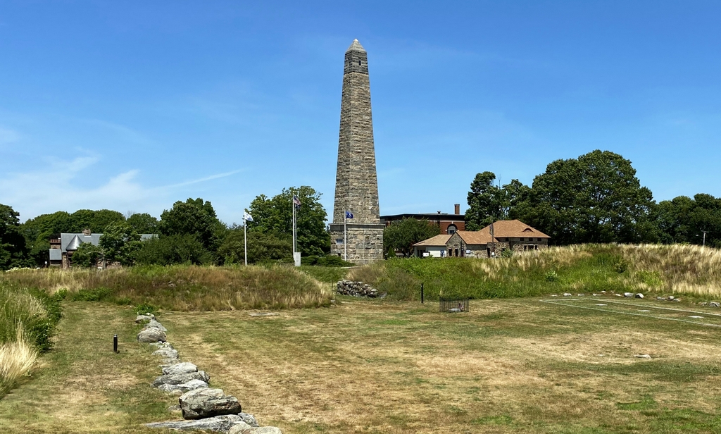
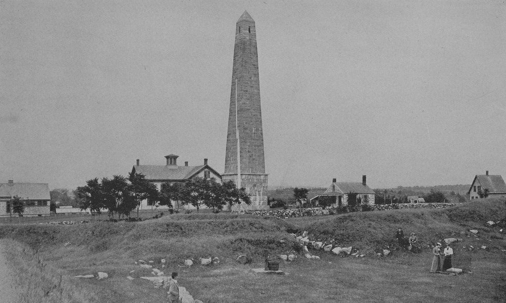
The view of Fort Griswold from the top of the Groton Monument in Groton, around 1900. Image from The Battle of Groton Heights (1903).

The scene in 2022:
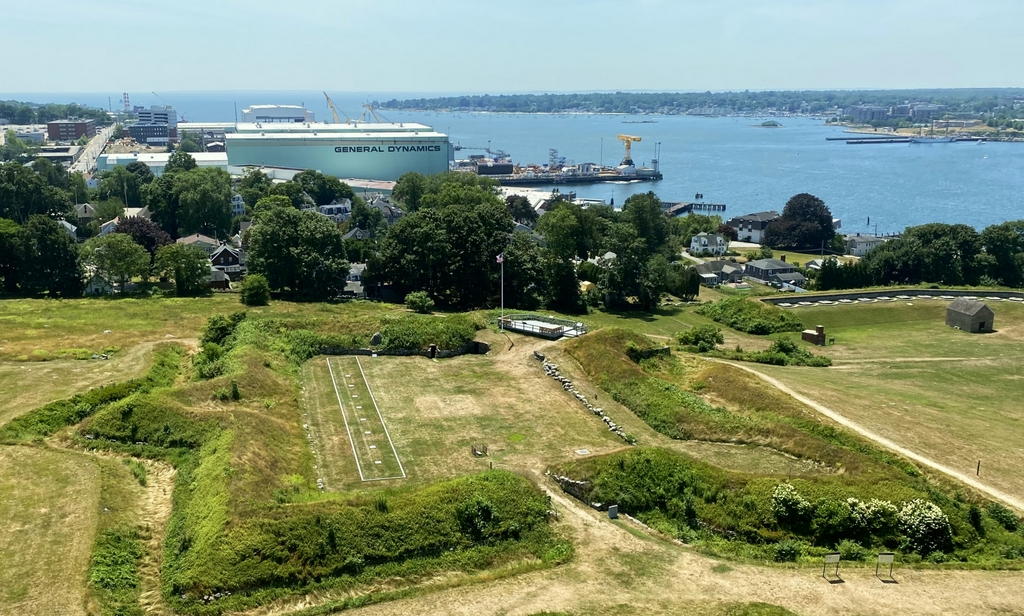
These two photos show Fort Griswold, which was built during the American Revolution on the east side of New London Harbor. Most significantly, the fort was the site of the Battle of Groton Heights on September 6, 1781. This battle is often overlooked, perhaps because it was a British victory that ultimately had little bearing on the outcome of the war. However, it was the largest battle to be fought in Connecticut during the Revolution, and it was also the last major battle in the northern states.

Fort Griswold was built between 1775 and 1778 on Groton Heights, a hill immediately to the east of New London Harbor. The site is less than a thousand feet from the water, yet it rises to about 125 feet in elevation, making it an ideal place for a fort to defend New London, which is located directly across the harbor. It was named in honor of Matthew Griswold, who was at the time the lieutenant governor and would eventually become governor of Connecticut. Aside from this fort, the harbor defenses also included Fort Trumbull in New London, which was named for Jonathan Trumbull, who served as governor from 1769 to 1784. Fort Trumbull is visible in the distance of both of these photos, across the harbor on the far right side of the scene.

Fort Griswold was laid out as a star fort, roughly pentagonal in shape, with bastions projecting outward to enable enfilading fire against attackers. The walls, which were made of stone topped with earth, were thick and relatively low, in order to protect against enemy artillery, and it was surrounded by a ditch to make it more difficult for the enemy to scale the walls. This was a typical fort design for the 18th century, although much smaller in scale than more notable ones of the era, such as Fort Ticonderoga and Fort Crown Point. The main entrance was on the north side, as shown here in the foreground of these two photos, but there was also a sally port on the south side of the fort that led to ditch connecting the fort to the lower battery. On the inside of the fort were the barracks, which were located on the east side, on the spot now marked by a large rectangular outline in the second photo.

Stephen Hempstead, who was one of the fort’s defenders during the battle, provided the following description of Fort Griswold in his subsequent account of the battle:

The fort was an oblong square, with bastions at opposite angles, its longest side fronting the river in a northwest and southeast direction. Its walls were of stone, and were ten or twelve feet high on the lower side, and surrounded by a ditch. On the wall were pickets, projecting over twelve feet; above this was a parapet with embrasures, and within a platform for the cannon, and a step to mount upon to shoot over the parapet with small arms. In the southwest bastion was a flag-staff, and in the side, near the opposite angle, was the gate, in front of which was a triangular breast-work to protect the gate; and to the right of this was a redoubt, with a three-pounder in it, which was about 120 yards from the gate. Between the fort and the river was another battery, with a covered way, but which could not be used in this attack, as the enemy appeared in a different quarter.

These defenses would be put to the test on September 6, 1781, when Benedict Arnold landed around 1,700 British soldiers here in the New London area. By this point the war in the north was winding down, and most of the focus had shifted south, where Lord Cornwallis had taken up a vulnerable position on a peninsula in Virginia. George Washington and Rochambeau had begun marching their army south in the summer of 1781, but Arnold hoped that a raid on New London would distract Washington and take pressure off of Cornwallis.

In conducting the raid, Arnold divided his force of about 1,700 men into two groups of roughly equal numbers. One group, commanded by Arnold himself, landed on the west side of the Thames River in New London. They met with minimal resistance at Fort Trumbull, which had been lightly garrisoned, and the 23 defenders who had been positioned there abandoned the fort after spiking the guns. Those defenders then crossed the harbor to join the American soldiers at Fort Griswold, which was a much more substantial fortification. In the meantime, Arnold had free reign of New London, and he burned a significant portion of it, including over 140 buildings. Adding insult to this injury was the fact that Arnold was a local, having been born and raised in nearby Norwich.

While Arnold was burning New London, the other group of about 800 British soldiers landed in Groton, on the east side of the Thames River. They were commanded by Lieutenant Colonel Edmund Eyre, who had been given the task of capturing Fort Griswold. Rather than attempting a frontal assault directly from the river, Eyre instead landed his men further to the south, at the entrance to the harbor in the distant left side of these two photos. This spot is marked by a small “4” in the first photo. This route of attack enabled him to approach the fort from the southeast, which, as noted in Stephen Hempstead’s account, rendered the lower battery ineffective against them.

According to Arnold’s post-battle report, his orders to Eyre were at least partially based on information that he had received from a Loyalist resident of New London, who informed him that the fort was only partially complete and was only defended by 20 or 30 men. However, in reality the fort had about 160 defenders, and Arnold would soon discover that it was definitely not incomplete. From a vantage point at the old burial ground in New London, Arnold surveyed the fort’s defenses, and subsequently wrote in his report that he “found it much more formidable than I expected, or than I had formed an idea of, from the information I had before received.” This led him to countermand his original orders to Eyre, but the message arrived after the battle had already started.

Prior to the battle, Eyre had demanded the unconditional surrender of the fort. With about 800 soldiers, he had a significant numerical advantage, but the fort’s commanding officer, Lieutenant Colonel William Ledyard, refused to surrender. Throughout the war, the British tended to avoid assaulting fortified, elevated American positions, likely in part because of their experiences early in the war at Bunker Hill. Ledyard may have had Bunker Hill in mind on this day, but he also believed that there were reinforcements who would arrive momentarily, so he held his position.

After the rejected surrender demand, Colonel Eyre concentrated his attack on the southwest bastion of the fort, located in the far right-hand side of the fort from the perspective of these two photos. They suffered heavy casualties in the process, including Major William Montgomery, who was impaled with a pike by Jordan Freeman, a formerly enslaved man who was subsequently killed in the battle.

According to Stephen Hempstead’s account, at one point in the battle the fort’s flagpole was shot down. The flag was quickly raised on a pike, but Hempstead believed that the British had interpreted the initial falling of the flag as a sign of surrender. This, he asserted, had given them the added motivation to get over the walls because they believed victory was at hand. It is also possible that the British may have seen the action as a feigned surrender designed to draw them into a vulnerable position. If that was the case, it may explain their subsequent actions once they breached the fort.

Regardless of exactly how the fallen flag may have influenced the British, they managed to get some of their soldiers over the walls. They then opened the gate from the inside, allowing the rest of the soldiers to enter the fort. It was at this point that Colonel Ledyard recognized that the battle was lost. Stephen Hempstead, who had been wounded by a musket ball in his left arm in the fighting right before this, described the ensuing events in his narrative:

Colonel Ledyard, seeing the enemy within the fort, gave orders to cease firing, and to throw down our arms, as the fort had surrendered. We did so, but they continued firing upon us, crossed the fort and opened the gate, when they marched in, firing in platoons upon those who were retreating to the magazine and barrack-rooms for safety. At this moment the renegade Colonel Beckwith commanding, cried out “Who commands this garrison?” Colonel Ledyard, who was standing near me, answered “I did, sir, but you do now,” at the same time stepping forward, handed him his sword with the point towards himself. At this instant I perceived a soldier in the act of bayonetting me from behind. I turned suddenly round and grasped his bayonet, endeavoring to unship it, and knock off the thrust, but in vain. Having but one hand, he succeeded in forcing it into my right hip, above the joint, and just below the abdomen, and crushed me to the ground. The first person I saw afterwards was my brave commander, a corpse by my side, having been run through the body with his own sword, by the savage renegade.

Over the years there has been debate and speculation about exactly who killed Colonel Ledyard, but American accounts of the battle generally agree on what happened next. Up to this point, only about six or seven Americans had been killed in the battle, according to Hempstead’s estimate. However, many more would be killed here in the fort after this attempted surrender. Hempstead continued by writing:

Never was a scene of more brutal wanton carnage witnessed than now took place. The enemy were still firing upon us in platoons, and in the barrack-rooms, which were continued for some minutes, when they discovered they were in danger of being blown up, by communicating fire to the powder scattered at the mouth of the magazine while delivering out cartridges; nor did it then cease in the rooms for some minutes longer. All this time the bayonet was “freely used,” even on those who were helplessly wounded and in the agonies of death. I recollect Captain William Seymour, a volunteer from Hartford, had thirteen bayonet wounds, although his knee had previously been shattered by a ball, so much so, that it was obliged to be amputated the next day. But I need not mention particular cases. I have already said that we had six killed and eighteen wounded previous to their storming our lines; eighty-five were killed in all, thirty-five mortally and dangerously wounded, and forty taken prisoners to New York, most of them slightly hurt.

Another American soldier, Rufus Avery, gave a similar account in his own description of the battle:

They killed and wounded nearly every man in the fort as quick as they could, which was done in about one minute. I expected my time to come with the rest. One mad-looking fellow put his bayonet to my side, and swore, “bejasus, he would skipper me.” I looked him very earnestly in the face and eyes, and asked for mercy and to spare my life. He attempted three times to put the bayonet in me, but I must say I believe God forbade him, for I was completely in his power, as well as others that was present with the enemy. The enemy at the same time massacred Lieut. Enoch Stanton within four or five feet of me. A platoon of about ten men marched up near where I stood, where two large outer doors to the magazine made a space wide enough for ten men to stand in one rank. They discharged their guns into the magazine among the dead and wounded, and some well ones, and some they killed and wounded.

Like Hempstead, Avery also commented on how the British became concerned that they would ignite the powder magazine. He wrote:

That platoon fell back, and another platoon came forward to discharge their guns into the outer part of the magazine, where the others did. As they made ready to fire, Capt. Bloomfield came suddenly round the corner of the magazine, and very quickly raised his sword, exclaiming, “Stop firing! You’ll send us all to hell together ! ” Their language was bad as well as their conduct. I was near him when he spoke. Bloomfield knew there must be, of course, much powder scattered about the magazine, and a great quantity deposited there, but I expect the reason it did not take fire was that there was so much human blood to put it out. They did not bayonet many after they ceased firing their guns. I was amongst them all the time, and they very soon left off killing, and then went stripping and robbing the dead and wounded, and also those that were not wounded.

As the battle came to an end, the British began taking prisoners. They also attempted to destroy the fort itself, but they were not successful. In his official report to his commanding officer, Sir Henry Clinton, Arnold described how:

A very considerable Magazine of Powder, and Barracks to contain 300 men, were found in Fort Griswold, which Captain Lemoine, of the Royal Artillery, had my positive directions to destroy. An attempt was made by him, but unfortunately failed. He had my orders to make a second attempt. The reason why it was not done Captain Lemoine will have the honor to explain to your Excellency.

Arnold’s report did not specify exactly why the first attempt failed, or why the second one was not carried out, although his tone clearly indicated frustration with Lemoine’s inaction. However, Lemoine did subsequently offer his explanation to Clinton, who indicated that he was satisfied with the reason.

Based on other accounts, the reason for the failure of the first attempt appears to have been due to interference by Americans who disrupted the trail of powder that was supposed to ignite the magazine. Another American who was present at the battle, John Hempsted, described the incident in a narrative that was somewhat less polished than Arnold’s report:

But the Enemy Intended to blow up the fort for they Stroed a train of powder from the gate to the magesean & itt burnt from the gate about half way to the magesean, and the Comunication was cut of by a mans fingers which Sean in the durt.

The Americans ultimately managed to save the fort itself, but overall they had sustained heavy losses in the battle. Different sources give somewhat different figures for the total number killed, wounded, and captured, but Stephen Hempstead’s estimates, which were quoted earlier, seem to be reasonably correct, with about 85 killed, 35 wounded, and 40 taken prisoner. The wounded figure included those who would subsequently die of their wounds, along with those who were deemed to be too injured to be taken prisoner, including Stephen Hempstead. Among the prisoners was Rufus Avery, who was subsequently transported to New York.

In his report, Benedict Arnold also stated that 85 Americans had been killed, although he also estimated that 60 were wounded (“most of them mortally”), and 70 captured. These latter two figures are likely inflated, since that would put the total number killed, wounded, and captured at 215, which was significantly higher than the total number of defenders who were present in the fort. As for the British, Arnold reported 48 killed and 145 wounded, and also noted that three of the wounded officers had since died. Other wounded British soldiers appear to have died of their wounds while making the voyage back across the Atlantic.

Based on these numbers, both sides had similar numbers of casualties, although for the Americans these represented a much higher percentage of their total force. With at least 85 dead in the battle, plus others who were mortally wounded, it meant that well over half of the fort’s defenders died during or soon after the battle. And, with nearly all of the remaining American soldiers either wounded or taken prisoner, it meant that they had a casualty rate of nearly 100%. Because of this, and because so many of the Americans were killed after they attempted to surrender, the battle is sometimes referred to as the Fort Griswold Massacre. At least one modern historian, Jerald P. Hurwitz, has even taken this a step further, declaring it to be the “Alamo of the Revolution” in his 2020 book of the same name.

For the British, the battle probably brought back memories of the Battle of Bunker Hill, which had been fought six years earlier at the start of the Revolution. Like Fort Griswold, it was a battle that they technically won, but it was largely a pyrrhic victory that involved heavy losses without gaining any significant strategic advantage. It would also prove to be their last major victory of the war. The goal of distracting Washington’s army did not succeed, and they continued on their way to Virginia despite the raid on New London and Groton.

Just 22 days after the battle here in Groton, the combined French and American armies began laying siege to General Cornwallis on the Yorktown Peninsula. This ultimately led to his surrender on October 19, 1781, which effectively ended the American Revolution. Interestingly, the total number of American and French soldiers killed in the three-week siege was about 88, which was approximately the same number who were killed here in Fort Griswold in the span of 40 minutes.

Following the was, Fort Griswold would continue to be used as a harbor defense fort for many years, although primarily in a supporting role, with Fort Trumbull becoming the main fort here in New London. Fort Griswold saw use during the War of 1812, and then in the early 1840s the lower batter was rebuilt, as shown on the right side of these photos. This work included emplacements for 20 guns, along with a powder magazine and a shot furnace. The latter was used to heat cannonballs before firing them, in order to start fires when they struck wooden warships. Both structures were built in 1843, and they are still standing today, with the magazine visible on the far right and the furnace a little to the left of it.

In the meantime, the battlefield also became the site of one of the earliest large-scale monuments to the American Revolution. In 1825, work began on a 127-foot monument just to the north of the fort. The cornerstone was laid on September 6, 1781, on the 44th anniversary of the battle, and approximately 8,000-10,000 people attended the ceremony, including 18 survivors of the battle. One of them even wore the same vest that he had worn during the battle, complete with a musket ball hole and other damage from the battle.

This event occurred less than three months after the cornerstone was laid for the more famous Bunker Hill Monument in Charlestown, Massachusetts. It had a design that was similar to the Bunker Hill Monument, although it was topped with a cupola rather than a traditional obelisk point. It was much shorter than Bunker Hill, standing at 127 feet compared to 221 feet. However, it also took much less time to build; it was completed in 1830, compared to 1843 for the Bunker Hill Monument.

The design of the Groton Monument was later modified for the centennial of the battle in 1881. The original cupola was removed, and the top of the monument was reconstructed to make it a true obelisk. This project added eight feet to the monument’s height, which now rises 135 feet above the battlefield.

The interior of the monument has a spiral staircase that leads to an observation platform with one window on each side of the monument. These windows provide expansive views of New London, the harbor, and the surrounding countryside, along with a birds-eye view of Fort Griswold, as shown in these two photos. From here, it is easy to get a sense of the layout of the fort and the topography around it, and also to visualize how the battle unfolded.

Even after the completion of the monument, the fort itself would remain an active military installation for many years. The lower battery, which had been reconstructed in the 1840s, was upgraded again around the time of the Civil War, including the installation of Rodman guns. It would ultimately continue to be used until after World War II, although for most of this time it was only lightly garrisoned, and never saw any other combat.

The site of the fort was subsequently transferred to the state, which established the Fort Griswold State Park here in 1953. Today, the park includes the fort itself, along with the monument and a small museum adjacent to it in the Monument House. Visitors can climb up the 166 steps to the top of the monument, and they can also explore the fort, which is open for self-guided tours.

Overall, the battlefield has not changed much in the 120 years or so since the first photo was taken. Although the battle is often overlooked when compared to the other major battles of the war, the site here has remained well-preserved, even as the surrounding area has been extensively developed over the years. There are now far more houses on the other side of the battlefield than there were in the first photo, and probably the most significant change is the large General Dynamics Electric Boat shipyard in the distance. This facility specializes in building nuclear-powered submarines for the U.S. Navy, so its proximity to Fort Griswold provides for an interesting contrast to the Revolutionary-era fort in the foreground.

First Church of Christ, Farmington, Connecticut

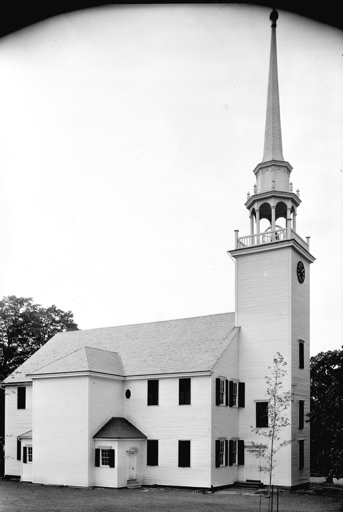
The First Church of Christ, Congregational, on Main Street in Farmington, on July 29, 1940. Image courtesy of the Library of Congress, Historic American Buildings Survey Collection.

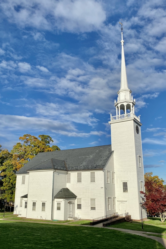
The church in 2021:

Farmington’s First Church of Christ, shown here in these two photos, stands as one of the best surviving examples of a colonial-era meetinghouse in Connecticut. It was completed in 1772, and it was designed and constructed by Judah Woodruff, a local builder who was responsible for many houses in Farmington during this period. As was the case for other meetinghouses of the era, it served as the religious, social, and political center of the town, functioning as a place not only for church services, but also for town meetings and other gatherings.

The church was established in 1652, and it occupied two earlier meetinghouses. The details of the first one are unclear, but the second one was completed in 1714, and it stood here in the vicinity of the present-day structure. This second meetinghouse was small and poorly built, and it had to serve the needs of a growing town. At the time, Farmington was significantly larger geographically, and included present-day towns such as Avon, Berlin, Bristol, Burlington, New Britain, Plainville, and Southington. Many of these places had their own parish churches by the mid-1700s, but their inhabitants still had to come here to Farmington for the town meetings.

By the late 1760s, the town had begun the process of planning for a new meetinghouse, and the construction work began in 1771, as indicated by the “July AD 1771” inscribed on one of the foundation stones. It was completed a little over a year later, and the dedication ceremony occurred on November 25, 1772. The architecture of the building is typical for colonial meetinghouses of its era, with a main entrance on the long side of the building and a steeple that is set off to the side. It would not be until the late 18th century that this trend shifted, and it became more common for meetinghouses to have main entrances on the gabled end of the building, and a steeple that rises from the roof above that entrance.

The interior of the Farmington meeting house likewise reflected colonial-era styles. The pulpit was located in the middle of the long side of the building, so that the interior was much wider than it was long, in contrast to later church designs. On the main floor were a series of box pews that were rented by families, and there were more pews on the gallery, along with rows of benches in front of them. As was the case in most colonial meetinghouses, seating reflected social status, and the more prominent families generally occupied the pews closer to the front, while young unmarried people, along with people of color, were usually in the less desirable seats in the gallery.

When the current meetinghouse was constructed, the pastor of the church was Timothy Pitkin. A 1747 graduate of Yale, Pitkin had subsequently married Temperance Clap, daughter of Yale president Thomas Clap, and then became the pastor here in Farmington in 1752. He came from a prominent Connecticut family; his father, William Pitkin, was the colonial governor from 1766 to 1769, and Timothy’s son, also named Timothy, was in the U.S. House of Representatives from 1805 to 1819. Aside from serving as pastor, Pitkin was also a benefactor of the new meetinghouse; he contributed 20 pounds toward its construction, which was a significant part of his 125 pound annual salary.

The meetinghouse was completed right around the time when Connecticut and the other colonies were dealing with questions relating to British authority. Here in Farmington, residents condemned the so-called Intolerable Acts, which Parliament had passed in response to the Boston Tea Party. At a June 1774 town meeting here, the voters of Farmington declared their opposition to “such arbitrary and tyrannical acts,” and they approved a measure to gather food and transport it to Boston to aid the beleaguered residents there.

Then, in September the town approved the purchase of stockpiles of lead, flints, and powder, and in December it indicated its support for the resolutions of the First Continental Congress. However, not everyone in the town was apparently united in their support. The town records also indicate that, at the December meeting, Matthias Loaming, and Nehemiah Royce were declared to be “Open Enemies to their country” for refusing to vote on the measure. As a result, the town voted to “withdraw all connection from them, untill they shall make Public Retraction of their Principles and Sentiments in the matters aforesaid.”

Once the Revolution started, Farmington supported the Patriot cause. At a town meeting here in March 1777, voters approved a bonus system to encourage residents to enlist in the Continental Army. Soldiers would receive five pounds upon enlistment, followed by another five pounds after completing one year of service. Then, in September the town approved providing two shirts and two pairs of stockings to those who were in the army.

Aside from approving expenditures to fight against British rule, another matter that came up here in the meetinghouse was the need to maintain decorum during worship services. In December 1772, soon after the meetinghouse opened, the town addressed the issue. As quoted in Noah Porter’s 1872 Historical Discourse on the church, the complaint was that:

[I]t is suggested by many members of this society that indecencies are practiced by the young people upon the Sabbath in time of public worship by frequently passing and repassing by one another in the galleries, and intermingling sexes to the great disturbance of many serious and well minded people.

Naturally, such scandalous behavior as unmarried people sitting with members of the opposite sex could not be tolerated here, so the town designated separate gallery staircases for men and women. However, it does not seem to have had the desired effect, because it was still an issue over 40 years later when, in a similar issue was raised in 1813. As quoted by Porter, the church declared:

that the practice of certain young gentlemen in themselves in the pews on the female side of the gallery in times of public worship is disorderly, and ought to be, and is, by this society, wholly disapproved of.

This issue was eventually resolved in the mid-1820s, when the pews in the galleries were replaced with slip pews, and young people were encouraged to sit with their families, rather than being largely unsupervised in the galleries. The old pews on the main floor were later replaced in 1836, and around this same time the original high pulpit was also removed. Another sign of changing times came in 1824, when the first stoves were installed. Prior to this time, as was typical for colonial-era meetinghouses, people would have to bring their own foot stoves if they wanted heat.

Perhaps the single most notable event in the history of this building is its involvement in the Amistad case. Farmington was one stop in the long odyssey of the survivors from La Amistad, as they traveled from Africa to Cuba to Connecticut, before ultimately returning to Africa. It began when a group of Mende people from Sierra Leone were captured and transported to Cuba. From there, 53 of them were sold in Havana and then transported on the schooner La Amistad. During this trip the Mendes, led by Cinqué, overpowered the small crew, killed the captain and cook, and forced the others to sail to Africa. However, the navigators deliberately kept the ship off course, and it was intercepted by U.S. authorities off the coast of New York City in August 1839.

This incident occurred in the midst of rising tensions in the United States surrounding the future of slavery, and it led to several important questions that the courts had to address. These included the issues of whether or not the Mendes had been legally enslaved, since the international slave trade was illegal in the United States, and also whether or not their mutiny had been a justifiable act of self defense. President Martin Van Buren, under pressure from Spanish authorities and from southern slave owners, favored returning them to Cuba. They were ultimately put on trial in Connecticut, with two different court cases in Hartford and New Haven. The court found in their favor, but the Van Buren administration appealed it to the Supreme Court, which upheld the lower court’s ruling in 1841.

With this decision, the Mendes were free, but they still had to get back home. They would end up spending much of 1841 in Farmington, where the abolitionist-minded community provided them with places to live while also working to raise money for their return trip to Africa. There were 36 survivors by the time they arrived in Farmington, with the rest having died at sea or while in prison. One more, a man named Foone, drowned while swimming in the Farmington Canal in August, but the other 35 remained here until November. Throughout this time, they regularly attended church services here in this building.

The town held a farewell service for them on November 17, here in the meetinghouse. The Reverend Joel Hawes of the First Church in Hartford preached a sermon for the occasion, based on the verse “And hath made of one blood all nations of men, for to dwell on all the face of the earth” from Acts 17:26. In his sermon, Hawes praised African culture, denounced the effects of slavery on the people of Africa, emphasized the sinfulness of racism, and reminded Christians about how all humans are a part of the same family. After the sermon, several of the Mendes spoke and sang, and then Cinqué delivered a narrative of their captivity. He spoke in his native language, and one of the other Amistad captives, Kinna, translated it into English for the crowd. They departed Farmington two days later on a canal boat, headed for New York. There, they attended another farewell service, and then boarded a ship to Sierra Leone, where they arrived in 1842.

In the years that followed, the old meetinghouse continued to stand here in the center of Farmington as an important town landmark. After 1830 it was no longer used for town meetings, a move that reflected changing attitudes surrounding the relationship between church and state, but it continued to be used by the First Church for its worship services. By the time the first photo was taken in 1940, the building was nearly 170 years old, yet its exterior had largely retained its architectural integrity.

Today, the First Church is still an active church congregation, and this building stands as a well-preserved example of a colonial-era New England meetinghouse. From this angle, there have been few changes aside from the addition of several windows and the removal of the shutters. These shutters would not have been original to the building, so they were probably removed in order to reflect its 18th century appearance. In 1972, the building was named as a contributing property in the Farmington Historic District, and then in 1975 it was individually designated as a National Historic Landmark.

Bradley Street, New London, Connecticut

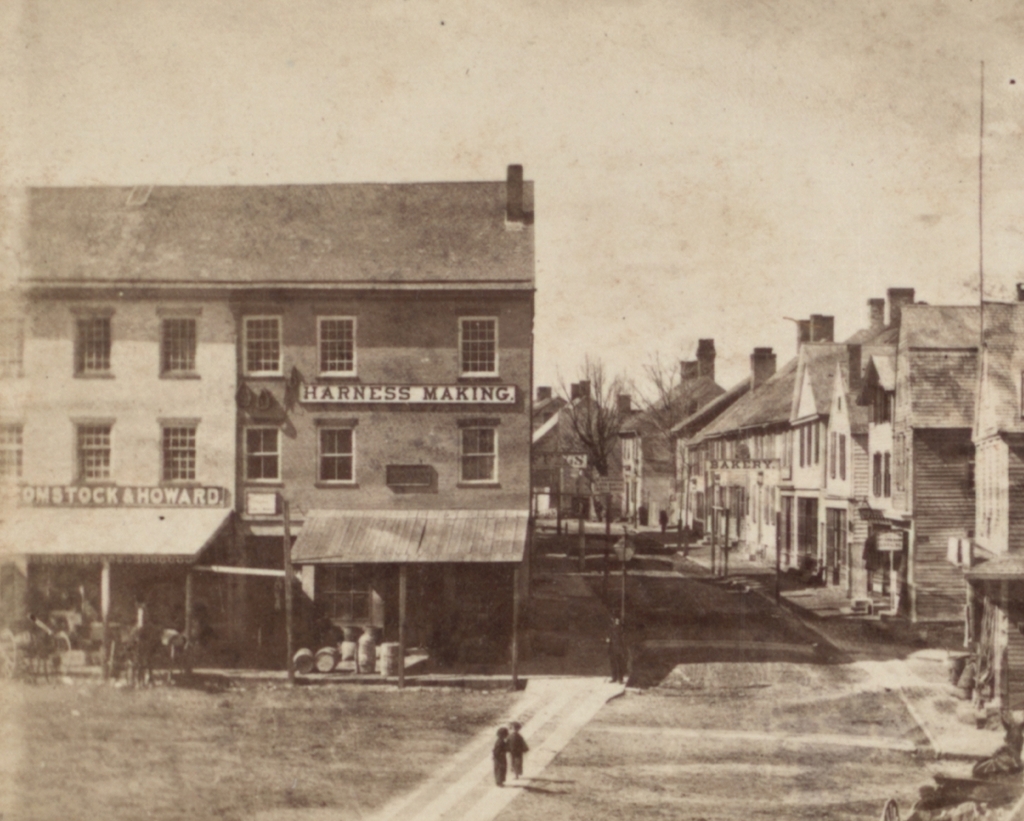
The view looking north on Bradley Street from the corner of State Street in New London, around 1868. Image courtesy of the New York Public Library.

The scene in 2021:

During the 1800s, New London was an important seaport, in particular because of its role in the whaling industry. At one point, it was second only to New Bedford in terms of number of whaling ships, which brought significant prosperity to the city. However, like other major ports, New London also had its share of crime, poverty, and vice, and perhaps no street in the city better exemplified this than Bradley Street, which is shown in the first photo around 1868.

At the time, Bradley Street began here at State Street, and it ran northward parallel to Main Street for three blocks, before ending at Federal Street. The northern end of the street was predominantly residential, but the southern end, shown here in this scene, had an assortment of commercial buildings, mostly older wood-frame structures.

There are a few signs that are visible in the first photo, advertising for businesses such as a harness maker at the corner of State Street and a bakery further down Bradley Street. However, the street was better known for its less reputable establishments, particularly its saloons and brothels. As early as the 1840s, women were convicted for running “houses of ill fame” here on Bradley Street, and the street would remain the epicenter of the city’s red light district into the early 20th century. Even Eugene O’Neill, the prominent playwright, would patronize these brothels as a young man while spending summers with his family in New London, and he made reference to one of the madams, “Mamie Burns,” in his famous play Long Day’s Journey into Night.

By the turn of the 20th century, when O’Neill would have made his visits to Bradley Street, the street was predominantly the home of working class immigrants, particularly Polish and Jewish families. However, the relatively short street also had up to 13 saloons and four brothels in operation by 1910, as outlined by Dr. Matthew Berger in a 2021 blog post.

In an effort to overcome the street’s seedy reputation, it was eventually rebranded as North Bank Street around 1921. Then, around the 1960s it became Atlantic Street, and it was about this same time that all of the older buildings on the street were demolished as part of an urban renewal project. The street was also truncated so that it now ends after just one block, rather than continuing all the way to Federal Street. The result is a streetscape that looks more or less like every other urban renewal project of the 1960s, with a parking garage on one side and a vaguely brutalist office building on the other side.

However, there is one historic building that stands in the present-day scene. On the far right side in the foreground is the Nathan Hale Schoolhouse. It was built in 1773, and the famous Revolutionary War hero taught here from 1774 to 1775. This is not its original location, though. It has been moved six times over the past 250 years, most recently in 2009 when it was brought to its current location at the corner of what had once been Bradley Street.

Ocean Bank, Stonington, Connecticut

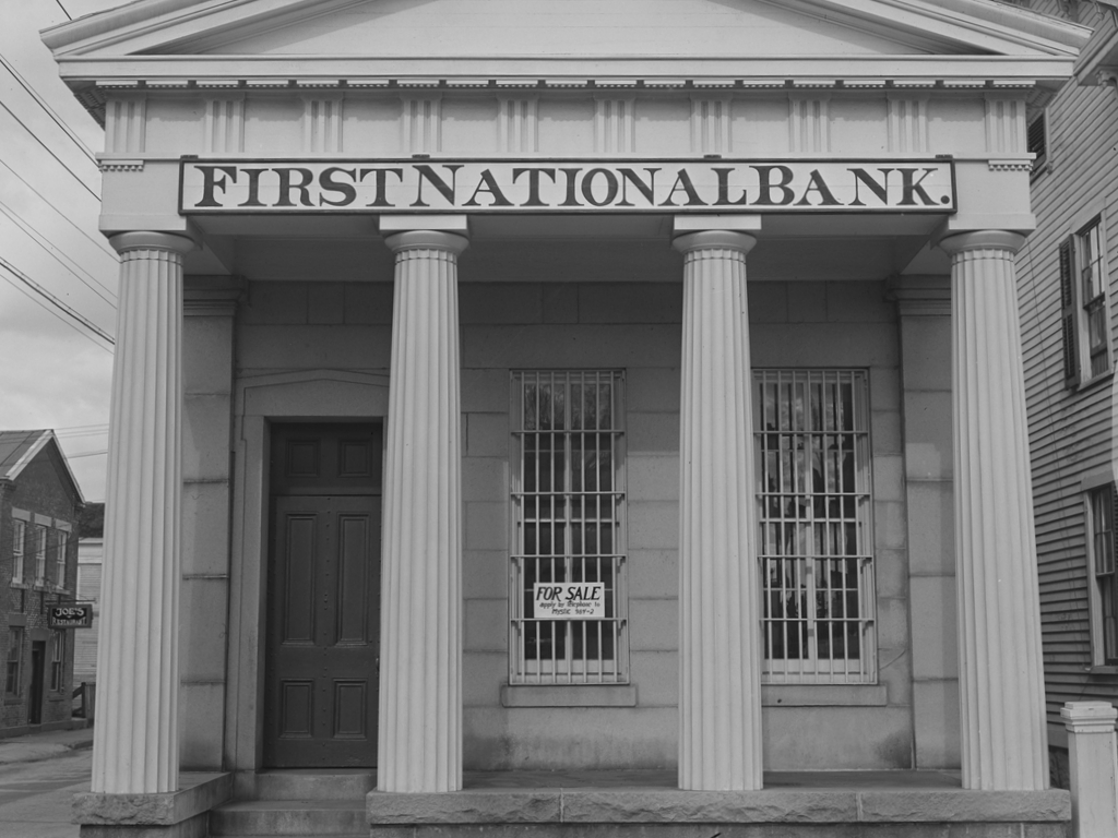
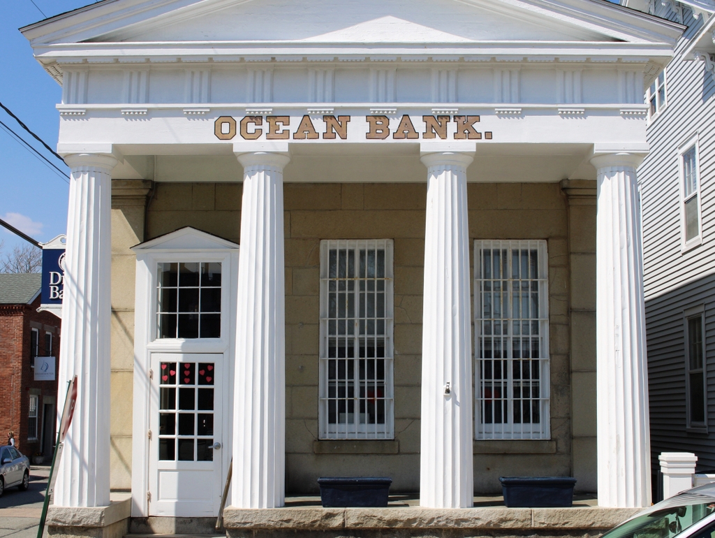
The First National Bank building, formerly the Ocean Bank, on the north side of Cannon Square in Stonington, in November 1940. Photo by Jack Delano, courtesy of the Library of Congress, FSA/OWI Collection.

The scene in 2021:

The first photo was taken in November 1940 by Jack Delano, a noted photographer who was employed by the Farm Security Administration in the late 1930s and early 1940s. In this capacity, he was part of a team of photographers who traveled around the country, documenting life in America during the Great Depression. He was in Connecticut during the fall of 1940, where he visited a number of cities and towns, including here in Stonington. His caption for this photo is simply, “A bank for sale in Stonington, Connecticut,” and he perhaps chose this subject as a way of representing the effects of the Depression on the once-prosperous whaling and fishing port.

Nearly a century before its demise in the Great Depression, the First National Bank of Stonington had its origins in 1851, with the incorporation of the Ocean Bank. This small Greek Revival bank building was constructed around this time, and the bank’s first president was Charles P. Williams, a former whaling ship captain. Williams had gained considerable wealth in the whaling industry, and he went on to further expand his fortune through real estate speculation. By the time he died in 1879, he was said to have been the wealthiest man in eastern Connecticut, with an estate valued at around $3 million.

In the meantime, the Ocean Bank became the First National Bank of Stonington in 1865, and it would remain in business here in this building for the next 75 years. However, the bank ultimately closed in February 1940, leaving the town of Stonington without any financial institutions. The bank’s president at the time, Judge J. Rodney Smith, explained in newspaper accounts that, although the bank itself was financially sound, the business conditions in town made the bank unprofitable for investors. He apparently did not cite specific reasons for this, but a likely cause was the ongoing Great Depression, along with the recent hurricane in September 1938, which battered coastal Connecticut.

As the sign in the first photo shows, the bank building was still for sale when Jack Delano took the photo some nine months after the bank closed. The building would ultimately be acquired by the Stonington Historical Society in 1942. The organization originally intended to turn the building into a museum and headquarters, but over the years it has instead been used as a rental property. Today, the historical society still owns the building, which has remained well-preserved in its 19th century appearance. It has also retained its original use as a bank, and it is currently a branch of Dime Bank, as shown on the sign on the left side in the 2021 photo.

Old Bacon Academy, Colchester, Connecticut

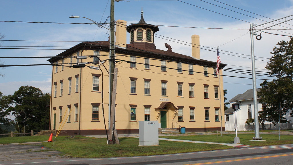
The Bacon Academy building at 84 Main Street in Colchester, around 1896. Image from Connecticut Quarterly.

The building in 2020:

Bacon Academy is one of the oldest public high schools in the United States, and the second oldest in Connecticut. It was established in 1803 following the death of Pierpont Bacon, a Colchester resident who bequeathed $35,000 to maintain a school for the town’s residents. At the time, a high school education was rare in the United States, and few towns had a high school, even here in the relatively well-educated northeast. For Bacon Academy, the main purpose was to prepare boys for college, so the school offered what was, at the time, regarded as a well-rounded education. An 1803 newspaper advertisement declared that students would “be accommodated with suitable instruction in Reading, Writing, Arithmetic, the learned Languages and Sciences.” Tuition in 1803 was $2.00 per quarter in the summer, and $2.50 per quarter in the winter.

The school opened on November 1, 1803, here in this brick, three-story Federal-style building. It is situated right in the center of Colchester, on Main Street directly opposite Norwich Avenue. Behind the school, visible in the distance on the left side of the scene, is the town’s old burying ground, which dates back to 1713. The opening of the school was widely reported in newspapers across the region, and the New York Morning Chronicle provided the following description of the building and its location:

A large and elegant brick building is erected for the accommodation of the scholars; being 75 feet in length, 34 feet in breadth, and three stories high. It is divided into a large hall, and convenient apartments for the different branches. . . . Colchester is a very healthy and pleasant town situated on the turnpike road leading from Hartford to New-London, being nearly equi-distant from each. A more eligible situation for an institution of this kind, could not have been chosen.

The first principal of the school was 31-year-old John Adams, a Connecticut native and Yale graduate who had previously taught at Plainfield Academy in New Jersey. He went on to become a prominent educator, serving here in Colchester until 1810, followed by 23 years as principal of Phillips Academy Andover. Later in life he moved west, serving from 1836 to 1843 as principal of Jacksonville Female Seminary, a school that would eventually be incorporated into Illinois College in the early 20th century.

During its first year, Bacon Academy enrolled 206 students. The majority of these were from Colchester, but 63 of them were from out of town. In its early years, the school even attracted students from out of state. Perhaps most notably, this included 11-year-old Stephen F. Austin of Missouri, whose father Moses Austin enrolled him in the school starting in the fall of 1804. Stephen Austin attended the school for the next three years, and he would eventually go on to become one of the founders of Texas and the namesake of its capital city.

Aside from Austin, Bacon Academy saw a number of its other students go on to achieve prominence in the 19th century. These included at least five future governors: William Larrabee of Iowa, Edwin D. Morgan of New York, Lyman Trumbull of Illinois, and William A. Buckingham and Morgan Bulkeley of Connecticut. With the exception of Larrabee, all of these men also served as U.S. senators, and Trumbull had a particularly distinguished career in the Senate, serving from 1855 to 1873. During this time, he co-authored the Thirteenth Amendment, which outlawed slavery. Other distinguished Bacon Academy students included Eliphalet A. Bulkeley, who became the first president of Aetna Insurance Company, and Morrison Waite, who served as chief justice of the United States from 1874 to 1888.

By the mid-1830s, the school had grown to 425 students, including 137 who were from out of town and 32 from out of state. For the first few decades, the student body consisted of white males, with a separate school here in Colchester to educate African American children. However, at least one African American, the prominent educator Prince Saunders, was associated with Bacon Academy only a few years after it opened. He ran the African American students, and he is said to have taken courses at Bacon Academy, although it does not seem clear as to whether he was formally enrolled at the school, or was taught outside of school by some of its teachers.

In any case, by the 1840s Bacon Academy was racially integrated, and it had begun to enroll female students. This period in the mid-19th century was a high point for the school, which had aspirations of becoming a top-tier college preparatory school similar to Phillips Academy. However, the school ultimately saw a decline in enrollment, in part because of this deviation from its original mission. Unable to compete with the more established private schools, by the late 19th century Bacon Academy had settled into the role of the public high school for residents of Colchester.

The first photo was taken around the mid-1890s, showing the main academy building in the foreground. On the far right side is Day Hall, an Italianate-style building that was completed in 1858 as a church hall for the adjacent First Congregational Church. By this point, the exterior of the academy had seen a few changes from its original appearance, including the door hood above the main entrance and the octagonal cupola atop the building. The photo shows shutters on the windows and a balustrade along the roof, although these may not have been original either; an 1836 engraving of the building does not show either of these features.

This building remained in use by Bacon Academy until 1962, when the school relocated to a new facility. The school subsequently moved again in 1993, to its current site a few miles to the west of here on Norwich Avenue, where Bacon Academy remains the town’s public high school nearly 220 years after it was first established. In the meantime, the old building here on Main Street is still standing, as is the neighboring Day Hall, which was acquired by the school in 1929. The exteriors of both buildings have remained well-preserved over the years, and the only noticeable difference to the academy building in this scene is the lack of shutters or balustrade. Because of its architectural and historic significance, the building was added to the National Register of Historic Places in 1982. In addition, both it and Day Hall are contributing properties in the Colchester Village Historic District, which was added to the National Register in 1994.

Judges Cave, New Haven, Connecticut

The Judges Cave on West Rock in New Haven, around 1901. Image courtesy of the Library of Congress, Detroit Publishing Company Collection.

The scene in 2024:

The immediate origins of the American Revolution can be traced back to the 1760s, when colonists began protesting taxes that were being levied on the colonies in the aftermath of the French and Indian War. However, this was hardly the first time that the colonies had defied the British crown. A century earlier, following the English Civil War and the eventual restoration of the monarchy, the colony of New Haven protected several regicides who had signed the death warrant of Charles I in 1649. This ultimately helped lead to the downfall of the colony and its merger with Connecticut in 1664, but none of the regicides were ever captured, and the incident has lived on in New England lore.

John Dixwell, William Goffe, and Edward Whalley were three military officers who had fought on the side of Parliament during the English Civil War in the 1640s. Following the defeat of the Royalists, King Charles I was captured put on trial for treason, and was found guilty of being a “tyrant, traitor, murderer and public enemy.” These three men were among the 59 commissioners who signed his death warrant, and he was subsequently beheaded on January 30, 1649.

This led to a decade-long interregnum, during which time Puritan leader Oliver Cromwell took on the title of Lord Protector of the Commonwealth of England. However, this government collapsed soon after Cromwell’s death in 1558, and in 1660 Charles II, the son of Charles I, returned from exile became king. That same year, Parliament passed the Indemnity and Oblivion Act, which pardoned most of the people who took part in the war but specifically excluded the 59 regicides and other high-ranking leaders who were connected to the trial and execution of Charles I. Over the next few years, royal officials tracked down many of these people, who were then imprisoned or executed. Even those who were already dead could not escape punishment; the bodies of Cromwell and several other dead regicides were exhumed from their graves, publicly executed, and then beheaded.

In the meantime, Dixwell, Goffe, and Whalley fled to the New World, to seek shelter among the Puritans. The exact date and location of Dixwell’s arrival is unknown, but he was presumed dead by the British and was not actively pursued by royal authorities. As for Goffe and Whalley, they arrived in Boston in July 1660, and they lived openly in Cambridge, before news of the Indemnity and Oblivion Act reached the colony in the fall. Over the next few months, the colonial leaders debated what to do about the two men. Although many were sympathetic to them and their cause, they feared the consequences to the colony if they continued to shelter them. So, on February 26, 1661 Goffe and Whalley left Cambridge for New Haven, where they arrived on March 7.

Here in New Haven, the men initially lived with the Reverend John Davenport. However, within a few months they were again in danger. News of their formal arrest warrant, dated March 5, reached New Haven around the end of April. This was soon followed by the arrival of royal officials in nearby Guilford, where they met with Governor William Leete. He managed to delay them in Guilford for several days, allowing Goffe and Whalley to quite literally take to the hills in order to escape arrest.

Goffe and Whalley spent several nights in temporary lodgings, aided by local farmers, before they were brought here to this rock formation on May 15. Although commonly referred to as Judges Cave, it is a cave in only the most generous sense of the word. In reality, it is a pile of boulders that, in a few areas, overhang enough to provide minimal shelter from the elements.  It is located high atop West Rock, a traprock ridge located about three miles northwest of the center of New Haven. At the time, this was a remote, sparsely-settled area, and they were able to live here for nearly a month without being detected.

Throughout this month, Goffe and Whalley received food every day from Richard Sperry, a local farmer who lived about a mile from here. They spent several nights at a nearby house during periods of inclement weather, but otherwise they lived here on the hill, which they named Providence Hill. In the meantime, royal officials were diligently searching for them in New Haven, offering generous rewards for their capture while also threatening Reverend Davenport for having aided them. The two regicides considered turning themselves in, in order to spare the colony any further trouble, but Governor Leete convinced them to remain in hiding. Within a few years, though, New Haven’s aid to the regicides would be a contributing factor in the demise of the colony, which was absorbed by the neighboring Connecticut colony in 1664.

According to legend, it was ultimately not royal officials who drove Goffe and Whalley from this cave, but rather a mountain lion that made an appearance at the entrance to the cave and frightened the two men. They left here on June 11, and lived at two other locations in the vicinity of West Rock for the next few months before finding more permanent lodgings at a house in Milford. They remained at this house for the next two or three years, before eventually moving to Hadley, Massachusetts, where they spent the rest of their lives in safety.

Because of the obvious need for secrecy in the movements of the regicides, there are few contemporary sources to corroborate these events. Perhaps the only primary source document was a diary that Goffe kept from 1660 to 1667, which he wrote in an easily-decipherable shorthand. This diary is now lost to history, but in the mid-1700s it was owned by Thomas Hutchinson, the royal lieutenant governor and later governor of the Province of Massachusetts Bay.

Aside from his role in colonial government, Hutchinson was also a historian, and in 1764 he published The History of the Colony of Massachusetts Bay. This book included an account of the regicides, which was based largely on Goffe’s journal. However, as a loyalist in the years leading up to the American Revolution, Hutchinson took a dim view of the regicides, and this bias is evident in much of his narrative. For example, he emphasizes the role that colonial officials had in trying to apprehend them, in an effort to portray the majority of 17th century New Englanders as having been loyal to the crown

Regardless of the biases, and the fact that it was written a century after the events happened, Hutchinson’s book provides the earliest significant account of the regicides and their flight through New England. The section relevant to their time here at Judges Cave, which is part of a lengthy footnote, reads as follows:

About that time, news came to Boston that ten of the judges were executed, and the governor received a royal mandate, dated March 5, 1660, to cause Whaley and Goffe to be secured. This greatly alarmed the country, and there is no doubt that the court were now in earnest in their endeavours to apprehend them; and to avoid all suspicion, they gave commission and instruction to two young merchants from England, Thomas Kellond and Thomas Kirk, zealous royalists, to go through the colonies, as far as Manhados, in search of them. They had friends who informed them what was doing, and they removed from Mr. Davenport’s to the house of one Jones, where they lay hid until the 11th of May, and then removed to a mill, and from thence, on the 13th, into the woods, where they met Jones and two of his companions, Sperry and Burril, who first conducted them to a place called hatchet-harbor, where they lay two nights, until a cave or hole in the side of a hill was prepared to conceal them. This hill they called Providence hill; and there they continued, from the 15th of May to the 11th of June, sometimes in the cave, and, in very tempestuous weather, in a house near to it. During this time, the messengers went through New-Haven to the Dutch settlement, from whence they returned to Boston by water. They made diligent search, and had full proof that the regicides had been seen at Mr. Davenport’s, and offered great rewards to English and Indians who should give information that they might be taken, but, by the fidelity of these three friends, they remained undiscovered.

Goffe’s journal remained in Hutchinson’s possession until 1765, when his house was ransacked by a Patriot mob in protest of the Stamp Act. The journal was either lost or destroyed in the process, making Hutchinson’s book the only surviving description of its contents. However, at least one other prominent historian, future Yale president Ezra Stiles, had the opportunity to examine the journal before its disappearance. He saw it during a 1763 visit to Hutchinson’s house, and he subsequently wrote his own history of the regicides.

Unlike Hutchinson’s description of the regicides, which fills just seven pages in his massive multi-volume history of the colony, Ezra Stiles published an entire book about their exploits in 1794. Titled A History of Three of the Judges of King Charles I, the book is over 350 pages long, and it relies heavily on oral traditions that were passed down to the descendants of the men involved in helping the regicides. Like Hutchinson’s account, Stiles’s book also has a political slant, although in the opposite direction. Writing just a decade after the American Revolution, in the midst of republican, anti-monarchical sentiment, Stiles viewed the regicides in a positive light, and he even included a chapter in which he justified their actions.

Stiles’s seemingly uncritical use of oral tradition in his book would come under criticism from later scholars, including biographer Edmund S. Morgan. Writing in his 1962 book The Gentle Puritan: A Life of Ezra Stiles, 1727-1795, Morgan asserted that it “represents Stiles at his worst. It is a tedious hodgepodge of fact and fancy, compounded mainly out of dim recollections by old men and women of things their grandfathers had told them fifty years before.” One such recollection, which relates to the Judges Cave, came from an interview with Joseph Sperry, whose grandfather Richard Sperry had aided the regicides in 1661. Stiles provided the following account in his book, including a description of this cave:

In 1785 I visited aged Mr. Joseph Sperry, then living, aged 76, a grandson of the first Richard, a son of Daniel Sperry, who died in 1751, aged 86, from whom Joseph received the whole family tradition. Daniel was the sixth son of Richard, and built a house at the south end of Sperry’s farm, in which Joseph now lives, not a half a mile west from the Cave, which Joseph shewed me. There is a notch in the mountain against Joseph’s house, through which I ascended along a very steep acclivity up to the Cave. From the south end of the mountain for three or four miles northward, there is no possible ascent or descent on the west side, but at this notch, so steep is the precipice of the rock. I found the Cave to be formed, on a base of perhaps forty feet square, by an irregular clump or pile of rocks, or huge broad pillars of stone, fifteen and twenty feet high, standing erect and elevated above the surrounding superficies of the mountain, and enveloped with trees and forest. These rocks coalescing or contiguous at top, furnished hollows or vacuities below, big enough to contain bedding and two or three persons. The apertures being closed with boughs of trees or otherwise, there might be found a well covered and convenient lodgement.

After this description of the cave and its surroundings, he wrote of what he learned from Joseph Sperry:

Here, Mr. Sperry told me, was the first lodgment of the Judges, and it has ever since gone and been known by the name of the Judges’ Cave to this day. Goffe’s Journal says, they entered this Cave the 15th of May, and continued in it till the 11th of June following—Richard Sperry daily supplied them with victuals from his house, about a mile off; sometimes carrying it himself, at other times sending it by one of his boys, tied up in cloth, ordering him to lay it on a certain stump and leave it: and when the boy went for it at night he always found the basons emptied of the provisions, and brought them home. The boy wondered at it, and used to ask his father the design of it, and he saw no body. His father only told him there was some body at work in the woods that wanted it. The sons always remembered it, and often told it to persons now living, and to Mr. Joseph Sperry particularply [sic].

They continued here till 11th of June. Mr. Joseph Sperry told me that the incident which broke them up from this Cave was this, that this mountain being a haunt for wild animals, one night as the Judges lay in bed, a panther, or catamount, putting his head into the door or aperture of the Cave, blazed his eye-balls in such a hideous manner upon them, as greatly affrighted them. One of them was so terrified by this grim and ferocious monster, her eyes and her squawling, that he took to his heels, and fled down the mountain to the Sperry’s house for safety. They thereupon considered this situation too dangerous, and quitted it. All the Sperry families have this tradition.

Aside from the events here in New Haven, the subsequent lives of Goffe and Whalley in Hadley are shrouded in mystery and legend. They lived at the home of the Reverend John Russell, but it appears that most townspeople were unaware of their identities. At some point around 1664, they were reunited with John Dixwell, the third regicide who had fled to New England. He eventually moved to New Haven, where he lived under the name John Davids until his death in 1689. Because the authorities believed that he was dead, he was able to live in relative security, and does not appear to have required the use of this cave or any other improvised shelters.

In the meantime, Edward Whalley died in Hadley around 1675 of natural causes, but Goffe lived long enough to become the subject of perhaps the most memorable regicide legend. According to tradition, at some point in either 1675 or 1676 the town of Hadley was facing an attack by Native Americans during King Philip’s War. The townspeople started panicking, but then an elderly man, identified in the legend as William Goffe, emerged and began to take charge. Some 30 years after he fought the Cavaliers on the battlefields of the English Civil War, he rallied the people and led their defense, and succeeded in saving the town. Then, as suddenly as he had appeared, the “Angel of Hadley” was gone.

As is the case for nearly all of the regicide-related stories, the first published account of the Angel of Hadley did not appear for nearly a century, until Thomas Hutchinson included it in his book in 1764. He included it at the end of his lengthy footnote on the movements of the regicides, writing:

The town of Hadley was alarmed by the Indians in 1675, in the time of publick worship, and the people were in the utmost confusion. Suddenly, a grave elderly person appeared in the midst of them. In his mien and dress he differed from the rest of the people. He not only encouraged them to defend themselves; but put himself at their head, rallied, instructed and led them on to encounter the enemy, who by this means were repulsed. As suddenly, the deliverer of Hadley disappeared. The people were left in consternation, utterly unable to account for this strange phœnomenon. It is not probable, that they were ever able to explain it. If Goffe had been then discovered, it must have come to the knowledge of those persons, who declare by their letters that they never knew what became of him.

Writing in his book 30 years after Hutchinson, Stiles repeats essentially the same account of the incident, although his wording tends to be more explicitly favorable to Goffe. Rather than describing him as “a grave elderly person,” Stiles writes of “a man of a very venerable aspect.” He copies Hutchinson’s wording by saying “the inhabitants could not account for the phœnomenon,” but then added “but considering that person as an Angel sent of God upon that special occasion for their deliverance; and for some time after said and believed that they had been delivered and saved by an Angel.”

Stiles’s romanticized description helped to solidify the idea of the “Angel of Hadley,” and by the early 19th century the story had become a part of early American folklore. In his 1823 novel Peveril of the Peak, Scottish writer Sir Walter Scott alluded to the incident, and in 1829 James Fenimore Cooper included it in his novel The Wept of Wish-ton-Wish. Nathaniel Hawthorne, who was never one to pass up a good story about the Puritans, also took inspiration from it. As a young man, he visited Judges Cave here in New Haven, and one of his early short stories, “The Gray Champion,” was loosely based on the Angel of Hadley legend. In the story, the title character is a shadowy, mysterious figure who embodies the Puritan ancestors of New England. Instead of defending a town against Native Americans, Hawthorne’s hero challenges the authoritarian rule of Edmund Andros in the 1680s. The Gray Champion disappears once the threat to the colony is over, but over the years he continues to make appearances whenever American liberty is at stake, including nearly a century later on the battlefields at Lexington and Bunker Hill.

Although Hutchinson’s and Stiles’s accounts provided plenty of material for 19th century authors, many historians began calling into question the accuracy of these tales, especially the ones that were handed down to Stiles through multi-generational hearsay. Legends such as the Angel of Hadley might very well have some basis in reality, but at this point it is difficult to sort out fact from fiction, given the inherent secrecy involved in the regicides and their activities here in New England. As for the tradition that the regicides spent a month hiding here in this rock formation, it is impossible to state with certainty that this is true. However, this belief does not seem to have been seriously questioned, and it seems plausible that this was, in fact, their hiding place during the spring of 1661.

The first photo was taken around 1901, showing the south side of the rock formation. By this point, the surrounding land was owned by the city of New Haven as part of West Rock Park. In the early 1890s a road was opened up here to the Judges Cave, and then in 1896 a plaque was installed here on the rocks. This plaque, which is visible here on the right side of the scene, commemorates the role that this site played in sheltering the regicides, and it was presented to the city by the Society of Colonial Wars. The formal dedication occurred on October 14, 1896, and it was attended by dignitaries such as Mayor Frederick B. Farnsworth, state adjutant general Edward E. Bradley, future governor Simeon E. Baldwin, and writer Charles Dudley Warner. Along with providing a short description of the regicides, the plaque features the phrase “opposition to tyrants is obedience to God,” which had apparently been inscribed on the rocks here as early as 1803.

Today, more than a century after the first photo was taken, the Judges Cave still looks essentially the same. It is still preserved as parkland, although it was acquired by the state in 1975, and it is now named West Rock Ridge State Park. The Judges Cave remains an important landmark within the park, and the only real difference between these two photos is the loss of the plaque, which was evidently stolen at some point. Its replacement is a somewhat larger plaque on the left side, although it bears the same inscription as the original one. It includes the same closing line about how “opposition to tyrants is obedience to God,” reflecting the beliefs that had led two Puritans across the Atlantic Ocean and to this secluded cave on the fringes of European settlements in the New World.