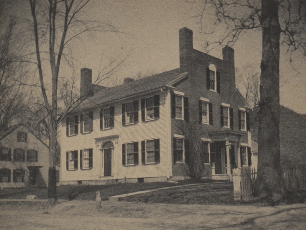
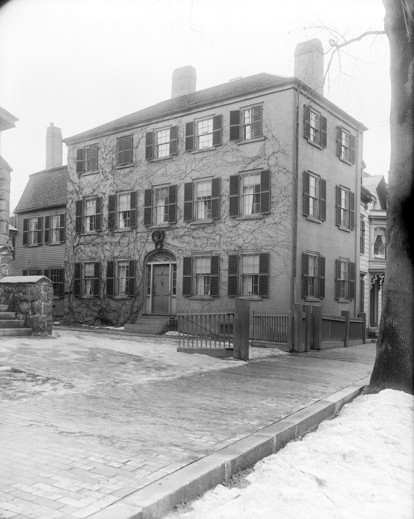
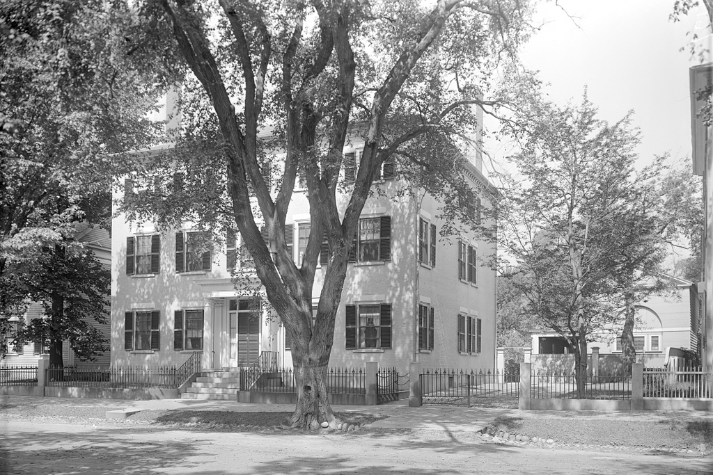
Chester Center, Chester, Massachusetts

The original town center of Chester, Massachusetts, seen looking south on modern-day Skyline Trail from the corner of Bromley Road around 1892. Image from Picturesque Hampden (1892).

The scene in 2024:

These two photos show the old town center of Chester, which was incorporated in 1765 and was originally named Murrayfield. Located in the far northwestern corner of Hampden County, Chester is one of the many hilltowns in the uplands region between the Connecticut River valley to the east and the Housatonic River valley to the west. Two of the branches of the Westfield River flow through Chester, with the West Branch in the western part of the town and the Middle Branch in the eastern section. The branches flow through narrow valleys, and in between them is a plateau of rolling hills.

It was this plateau that initially drew colonial settlers to Chester. The river valleys provided only a limited amount of potential farmland, but the hills were suitable for agriculture, particularly for raising livestock. As a result, the late 18th century development in the town was concentrated around this area on modern-day Skyline Trail, with this spot becoming the town center.

One of the first houses built here by colonists was the home of the town’s first pastor, the Reverend Aaron Bascom. Built in 1769, it is just out of view on the far left side of this scene, and it is still standing today, although it is vacant and badly deteriorated. The village here also included the town meetinghouse, along with a burial ground that is located in the distance on the left side of the road.

The population trends in Chester were consistent with what happened in many of the other hilltowns in this part of Western Massachusetts. It saw significant growth in the early 19th century, but subsequently declined in population as residents either moved west for better farmland or moved to industrial cities for greater opportunities. In Chester, the town’s population grew from 1,119 in 1790 to 1,542 in 1800, but it stagnated over the next few decades. The 1850 census marked the last time that the town ever recorded a population above 1,500, and since then it has generally fluctuated between about 1,000 and 1,400 residents.

Aside from the general decline in population during the mid-19th century, the town also saw changes in where people lived within the town. In 1841, the Western Railroad was built along the West Branch of the Westfield River. It passed through the southern and western parts of Chester, which helped to spur development in the river valley. This included the village of Chester Factories, which soon eclipsed the original town center here on what became known as Chester Hill.

The top photo was taken around 1892, showing the view looking south in the old town center. By this point the town’s population stood at about 1,300, and this was largely concentrated in the area around the railroad depot in the valley. Here on Chester Hill, the lack of population growth meant that things stayed essentially the same as they had been in the first half of the 19th century, with a handful of homes and other buildings clustered around the meeting house and burying ground.

The most prominent building in the top photo is the meetinghouse of the First Congregational Church. It was built in 1840, although it was constructed in part from timbers that had originally been used in the 1769 meetinghouse. It features a Greek Revival design, which was fashionable for church buildings of the period, and it was modeled after the meetinghouse in New Marlborough. As was often the case in small towns in Massachusetts at the time, it functioned as a house of worship but also as a space for town meetings, which were held in Chester Center through 1855, before the town meetings shifted to the settlement in the valley.

Across the street from the meetinghouse is the cemetery, with gravestones that date as far back as the 1760s. Next to the cemetery is the two-story district schoolhouse, which can be seen in the distance on the left side of the photo. It was built in 1796, and it was still in use as a school when the top photo was taken nearly a century later.

Aside from the meetinghouse and school, there are also two houses visible in the photo. On the far left side in the foreground is the Searle House, which was built in 1787 as the home of Zenas Searle. Across the street, on the far right side, is the Boies House, an elegant Federal-style house that was built in 1810 for the Rev. Bascom’s daughter Charlotte and her newlywed husband Dr. Anson Boies.

Today, more than 130 years after the top photo was taken, very little has changed in this scene, aside from the paved road in place of the dirt path. All four buildings are still standing with few alterations, and the village is a well-preserved example of a rural early 19th century town center. Along with the nearby Bascom House, these buildings are part of the Chester Center Historic District, which was added to the National Register of Historic Places in 1988.

James B. Bott House, Salem, Massachusetts

The house at 18 Chestnut Street, at the corner of Bott Street in Salem, probably around 1890-1910. Image courtesy of the Phillips Library at the Peabody Essex Museum, Frank Cousins Glass Plate Negatives Collection.

The house in 2023:

These two photos show the house at 18 Chestnut Street, which was built around 1800 or possibly earlier. It was originally owned by saddler James B. Bott, and according to the building’s Massachusetts Cultural Resource Information System (MACRIS) form, it was likely used as a multi-family residence. It had a number of occupants throughout the first half of the 19th century, but the most famous was author Nathaniel Hawthorne, who lived here with his family in 1846 and 1847 while serving as Surveyor of the the Port of Salem at the Custom House on Derby Street. This house was too small for the Hawthornes, though, and in 1847 they moved to a house on Mall Street, where Nathaniel would later write The Scarlet Letter.

The house was eventually converted into a single-family residence in the late 19th century, and the top photo was taken sometime around the turn of the 20th century. It was taken by photographer Frank Cousins, who extensively documented the historic houses of Salem and other towns in the region. As the bottom photo shows, very little has changed about this scene since then. The house is still standing, as are the other surrounding homes, and Chestnut Street as a whole survives as one of the best-preserved historic streets in New England. The Bott House, along with the other homes on Chestnut Street, is part of the Chestnut Street District, which was added to the National Register of Historic Places in 1973.

Chestnut Street, Salem, Massachusetts (2)

The view looking east on Chestnut Street from near Pickering Street in Salem, around 1890-1910. Image courtesy of the Phillips Library at the Peabody Essex Museum, Frank Cousins Glass Plate Negatives Collection.

The scene in 2023:

These two photos were taken from near the same spot as the ones in the previous post, but facing the opposite direction. This view of Chestnut Street, looking east toward Cambridge Street, features a number of early 19th century homes. Starting in the foreground on the right side is a double house at 21-23 Chestnut Street, which was built in 1814-15 for John and Henry Pickering. They were the sons of Timothy Pickering, a prominent politician who served in several different Cabinet positions, including as Secretary of State under George Washington and John Adams.

Although built for the Pickering brothers, they evidently did not own these houses for long, because each properly changed hands several times over the next few decades. By the 1830s, the house closest to the foreground, at 23 Chestnut, was owned by Robert Stone, while the adjoining house at 21 Chestnut was owned by Elisha Mack. In 1833, during President Andrew Jackson’s visit to Salem, Robert Stone hosted a reception here at his house, which Jackson attended along with Vice President Martin Van Buren, several Cabinet secretaries, and other dignitaries.

Further in the distance on the right side of the street is 19 Chestnut, which is visible in the center of both photos. This three-story, wood-frame house was built around 1805, and it was originally the home of merchant Israel Williams. Later in the 19th century it was owned by another merchant, Henry W. Peabody, and then in the early 20th century it was owned by architect William G. Rantoul.

Today, more than a century after the top photo was taken, these houses are still standing, as are the other ones further in the distance on both sides of the street. Chestnut Street survives as a well-preserved example of Federal-style architecture, and it is the centerpiece of the Chestnut Street District on the National Register of Historic Places. However, this scene is also notable because of the elm tree that still stands in the foreground. During the 19th and early 20th centuries, the street was lined with elms. Most of these were subsequently lost, likely due to hurricanes and Dutch Elm Disease, but this tree has survived, and it is still easily recognizable from its appearance in the top photo.

Chestnut Street, Salem, Massachusetts

The view looking west on Chestnut Street from the corner of Pickering Street, around 1906. Image courtesy of the Library of Congress, Detroit Publishing Company Collection.
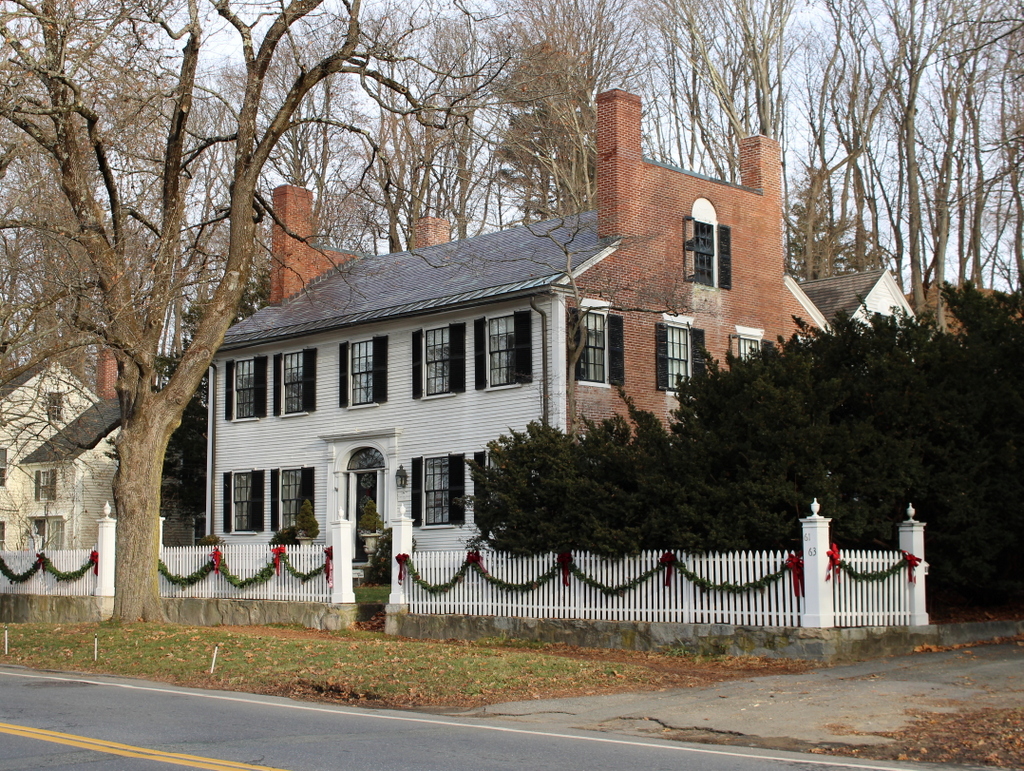
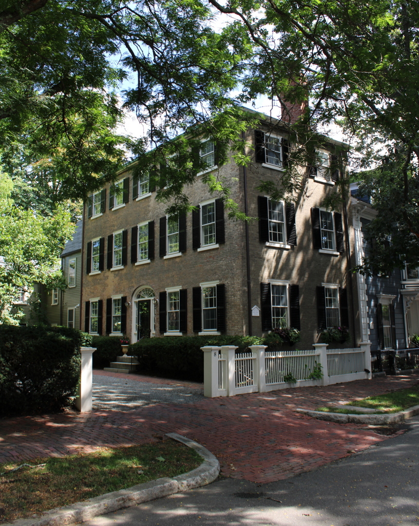
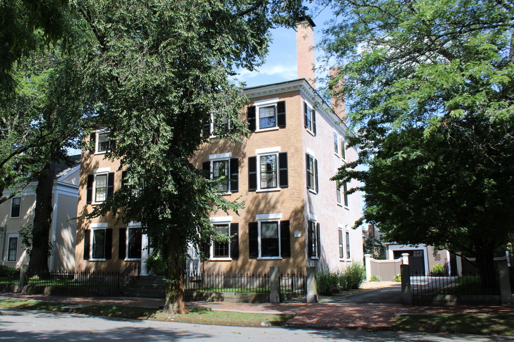
The scene in 2023:

During the late 18th and early 19th centuries, Salem was one of the most prosperous seaports in the United States. This was reflected in its architecture, which included many large, fashionable Federal-style homes that were built for merchants and other wealthy Salem residents. Many of these homes are located on the streets immediately to the west of downtown Salem, including Chestnut Street, as shown in these two photos.

Chestnut Street was laid out in 1796, and over the next few decades it was developed with stately homes. Only one house on the street is known to have been the work of prominent Salem architect Samuel McIntire, but his influence is clearly evident in the designs of the other houses here. Many of the houses are brick, although some are wood, and they are generally three stories high, have a hipped roof, and have a roughly square footprint. Most were designed as standalone single-family homes, but there are a few that were built as adjoining two-family homes.

By the time the top photo was taken at the turn of the 20th century, the street was already recognized as an important Salem landmark. Not only were the houses themselves significant, but the streetscape itself was also notable for the many elms that lined the street, creating a tunnel-like effect, as shown in the top photo.

Sadly, nearly all of the elms are gone now, likely as a result of Dutch Elm Disease. Today, the street is still lined by trees, but their lower canopies do not have the same effect that the elms once had. Despite the loss of the elms, though, not much else has changed in this scene. The tree cover makes it hard to tell, but all of the homes in the top photo are still standing. The street is one of the finest collections of Federal-style architecture anywhere in New England, and it forms the centerpiece of the Chestnut Street District, which was added to the National Register of Historic Places in 1973.


Devereux-Hoffman House, Salem, Massachusetts

The house at 26 Chestnut Street in Salem, probably around 1906-1910. Image courtesy of the Phillips Library at the Peabody Essex Museum, Frank Cousins Glass Plate Negatives Collection.

The house in 2023:

These two photos show one of the many historic early 19th century homes that line Chestnut Street in Salem. The street was laid out in 1796, and over the next few decades it was developed with large Federal-style homes for the merchants and other wealthy Salem residents. This particular house was built around 1826-1827 as the home of Humphrey and Eliza Devereux. The architect of the house is unknown, but its design is consistent with the other homes of this period on Chestnut Street, which were heavily influenced by the designs of Samuel McIntire.

Humphrey Devereux was a merchant and ship owner, and early in his career he spent time at sea, including making voyages to Europe and the East Indies. During the War of 1812, his ship was captured by the British, and he spent time as a prisoner in Bermuda. He later retired from life at sea, and instead focused on running his mercantile business from Salem.

He married his wife Eliza Dodge in 1809, and they had two children. Their son, George Humphrey Devereux, was born in 1809, and their daughter Mary Ann Cabot Devereux was born in 1812. They moved into this house around 1827, but Eliza died soon after, in 1828. Humphrey continued to live here for at least another decade, but by the 1840s he was living a few houses down the street from here, at 34 Chestnut Street.

This house was subsequently owned by another merchant, Charles Hoffman. Originally from Hamburg, Germany, he later immigrated to America, where he became one of Salem’s leading merchants in the West African trade during the mid-19th century, and he imported goods such as hides, palm oil, and nuts. He moved into this house a few years after his 1840 marriage to his second wife, Eliza King.

Charles and Eliza did not have any children, and the census records from the late 19th century show that they lived here alone except for two live-in servants. Aside from his business interests, Charles was also an amateur horticulturalist, and his house was well known for its well-maintained gardens and its greenhouses in the back of the house. He lived here until his death in 1878, but Eliza continued to live here into the early 20th century. The 1900 census shows here living here with her sister Harriet and three servants.

Eliza died in 1905, and the house was subsequently sold to Dr. James E. Simpson. He made some alterations to the house, and converted part of it into offices for his medical practice. This included adding a second entryway on the right side of the house, which served as the entrance to his offices. The top photo was taken within a few years after this work was completed.

The 1910 census shows James Simpson living here with his wife Gertrude, her mother Mary Ropes, and two servants. By 1920, the Simpsons had three servants, and the household also included James’s aunt Fannie. James lived here until his death in 1935, and Gertrude died five years later.

Overall, the house has seen few exterior changes since the top photo was taken. Its ivy-covered brick walls are still easily recognizable from the top photo, and the house stands as one of the many well-preserved Federal-style homes in this part of Salem. Along with the other houses in this area, it is now part of the Chestnut Street District, which was added to the National Register of Historic Places in 1973.

David Hoyt House, Deerfield, Massachusetts

The David Hoyt House on Old Main Street in Deerfield, on July 24, 1930. Image courtesy of the Boston Public Library; photographed by Leon Abdalian.

The house in 2023:

This house was built in 1803 near the southern end of Deerfield’s Old Main Street. It was originally the home of David Hoyt, and it was subsequently owned by several more generations of the Hoyt family, including his son Horatio Hoyt and grandson Horatio Hoyt Jr.

The house features Federal style architecture, including details such as ornate window casings and pediments above the first floor windows, along with a distinctive front doorway. Although not as large or elaborate as the Federal style homes that were being built in the coastal parts of Massachusetts during this time, the house is nonetheless a good example of this type of architecture here in the Connecticut River Valley.

The top photo was taken in 1930, and very little has changed here in nearly a century since then. Along with many other homes here in the center of Deerfield, it is now owned by Deerfield Academy, but the exterior remains nearly identical to when the top photo was taken. It is one of the many well-preserved historic homes here on Old Main Street, and it is a contributing property in the Deerfield Village Historic District, which was designated as a National Historic Landmark in 1966.