Newton and Asa Colton Houses, Longmeadow, Massachusetts

The houses at 817 and 809 Longmeadow Street in Longmeadow, looking north from the corner of Colton Place, in June 1921. Image courtesy of the Longmeadow Historical Society, Paesiello Emerson Collection.

The same scene in 2024:

As explained in the previous two posts, these houses once stood on the east side of the Longmeadow Green, and both were originally owned by the Colton family. The house in the foreground was built in 1823 as the home of Newton Colton, while the one farther in the distance was built around 1775 for Asa Colton. A third Colton house, at 797 Longmeadow Street, is also partially visible in the distance, and it is said to have been built in 1833 for Justin Colton, although it might be older than this.

The top photo was taken shortly before this scene was drastically changed. By the early 20th century, Longmeadow’s population was growing rapidly due to new suburban developments in the town, and this site was chosen for a new junior high school. To make room for the school, the two houses here in the foreground were both moved in 1921, with the Newton Colton house in the foreground being moved in July, about a month after the photo was taken.

Today, both of these houses are still standing in their new locations. The Newton Colton house was moved across the green to 870 Longmeadow Street, while the Asa Colton house was moved eastward from its original location, where it now stands at 44 Colton Place. The Justin Colton house, which did not need to be moved, is still standing here in its original location, and can be seen in the distance on the left side of the present-day photo.

The junior high school building later became Center Elementary School, and it underwent a major reconstruction in the mid-1990s. This involved completely gutting and rebuilding the interior, while leaving the exterior largely unchanged in its original 1920s Colonial Revival appearance, as shown in the present-day photo.

Longmeadow Street and Bliss Road, Longmeadow, Massachusetts

The view looking east toward the corner of Longmeadow Street and Bliss Road in Longmeadow, around 1910. Image photographed by Paesiello Emerson, courtesy of the Longmeadow Historical Society.

The same view in 2024:

These two photos show a view from the same vantage point as the ones in the previous post, just angled farther to the right. The photographer of the 1910 image, Paesiello Emerson, took the photo from the second-floor bedroom on the southeast corner of his house, at the corner of Longmeadow Street and Emerson Road. His image shows a changing landscape in Longmeadow, with an older farmhouse in the foreground and newer suburban homes in the background.

The house in the center of the top photo was apparently built sometime around the late 18th or early 19th centuries. It stood at the northeast corner of Longmeadow Street and Bliss Road, and the 1830 town map shows that it was owned by Samuel Stebbins. By the 1850s, it was owned by Sylvester Bliss, a farmer who lived here with his wife Nancy. They had four children: Hannah, Marilla, James, and Harriet. All four were living here with their parents during the 1880 census, and Bliss also employed two boys who lived and worked here. His property included about 30 acres that extended westward along the north side of Bliss Road as far as modern-day Laurel Street.

Sylvester Bliss died in 1887, and Nancy died a decade later. The top photo was taken around 1910, and the Bliss family still owned the property at this time, although they rented it to Clifford S. Kempton, a poultry farmer who was originally from Pennsylvania. During the 1910 census he was 53 years old, and he was living here with his wife Clara, their three children, and Clara’s brother Charles Breck. Their household also included 16-year-old Pearl Murphy, a Black domestic servant who was from North Carolina.

In 1913, the Bliss family sold this property to real estate developer Edwin H. Robbins. The land was then subdivided and new streets were laid out, including Belleclaire Avenue and Westmoreland Avenue. Most of the land was redeveloped with new single-family homes, but the spot here at the corner of Longmeadow Street and Bliss Road became the site of a commercial building known as the Colonnade. Rather than demolishing the old Bliss house, it was moved around the corner to a new lot on Bliss Road around 1914. However, it was destroyed by a fire just two years later. According to contemporary newspaper accounts, the fire was probably caused by defective wiring.

The Colonnade featured a variety of businesses, and early tenants included a drugstore, a grocery store, a meat market, a tailor, a shoemaker, and an automobile garage. It is still standing today, and it is visible in the center of the second photo, although its exterior has been heavily altered over the years. Aside from the construction of the Colonnade, other changes from the top photo include the demolition of the houses on the right side of Bliss Road, which can be seen in the distance on the right side of the top photo. This area on Bliss Road is now occupied by St. Mary’s Church and St. Mary’s Academy, which is partially visible on the far right side.

Longmeadow Street and Belleclaire Avenue, Longmeadow, Massachusetts

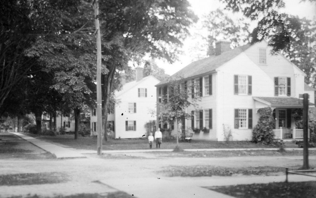
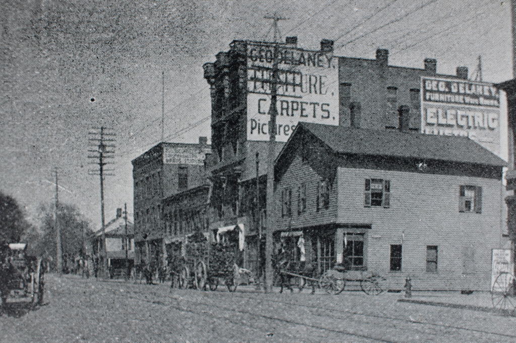
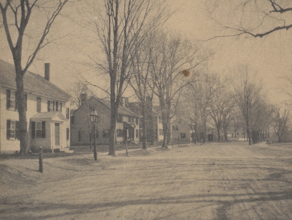
The view looking east toward the corner of Longmeadow Street and Belleclaire Avenue in Longmeadow, in January 1916. Image photographed by Paesiello Emerson, courtesy of the Longmeadow Historical Society.
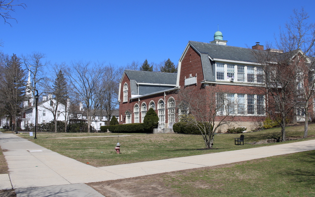
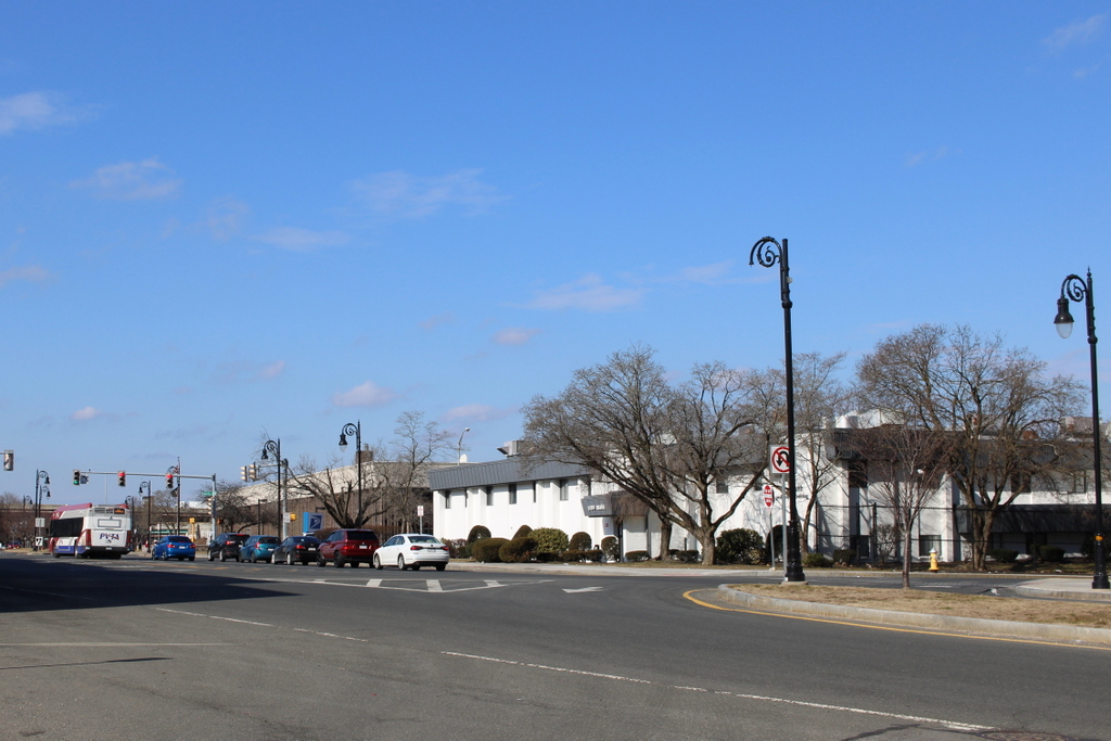
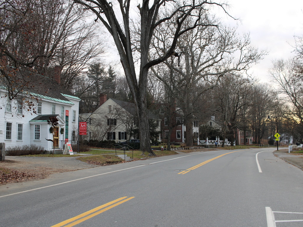
The scene in 2024:

These two photos were taken from the southeast bedroom on the second floor of the Josiah Cooley House. Built around 1760, this house stands at the corner of Longmeadow Street and Emerson Road, and during the early 20th century it was the home of Paesiello Emerson, an amateur photographer who used his camera to document life in Longmeadow.

The top photo shows some of the changes that were happening here in Longmeadow during this period. For much of its history, the town was relatively small. Most of the homes were located along Longmeadow Street, with long house lots that extended to the east and west of the street. There was minimal commercial or industrial development, and the town’s economy relied primarily on farming.

By 1900, the town had a population of just 811, but this would soon change due to the growth of Springfield, which is directly to the north of Longmeadow. A trolley line was built through the town, linking it to Springfield and also to Hartford, and it made it easy for residents to live in the town and commute into the city for work.

Over the next few decades, many of the old house lots were subdivided and developed with single-family homes. This included the land at the northeast corner of Longmeadow Street and Bliss Road, which had long been owned by the Bliss family. Around 1913, the Bliss family sold this land to Edwin H. Robbins, a real estate developer who named the subdivision “Brookline.” This was part of a strategy to market Longmeadow as Springfield’s equivalent to Brookline, which is an affluent suburb of Boston.

The Brookline subdivision consisted of homes along the north side of Bliss Road and east side of Longmeadow Street, along with the development of several new streets. Belleclaire Avenue and Westmoreland Avenue were laid out east to west, running parallel to Bliss Road. These streets were intersected by Dayton Street (later named Cross Street), Rosemore Street, and Lorenz Street, which ran north to south. From this view, Belleclaire Avenue is near the center of the photo, with Westmoreland Avenue farther in the distance on the left side.

Aside from naming it “Brookline,” Robbins also promoted this subdivision through regular advertisements in local newspapers. One such advertisement, published in the May 4, 1913 Springfield Republican, encouraged Springfield residents to move to Longmeadow, specifically to Brookline. He wrote:

You have thought that you would like to live in Longmeadow.

The reasons you had were these:

You would have every advantage you have in Springfield. Emphasis on the “every.”

You would have, in addition, all the delights of the country. These are:

  1. The pure country air, perfumed by the flowers and made vocal by the birds. Did you ever hear the birds’ May Festival?
  2. The absence of the many hideous sights and smells of the city, as well as the profanities and vulgarities you cannot help hearing.
  3. The closeness of the ties of friendships impossible anywhere but in a small community of congenial people. This is not obvious to a city dweller, but is a very real fact to the resident of a village community.

Think what these three advantages mean to growing children. You bring them up physically and morally clean, and you store their hearts with happy memories they will cherish in the strenuous days to come.

Your desire to live in Longmeadow is a true instinct. Follow it.

As to what “Brookline” is and will be, I want to say:—

1st. It has a beautiful location at the corner of Bliss Road, with a frontage of over 700 feet on Longmeadow Street, down to the Town House. It is level and high and perfectly dry, with a fine sand subsoil, and in no part underlaid with clay.

I am going to put in water, sewer, gas, electric lights. Trees now set out in the tree belts, and adequate cement sidewalks. The houses will be 100 feet apart across the streets, and I have restricted it so highly that I GUARANTEE YOU DESIRABLE NEIGHBORS, no matter how high your station in life may be.

I pledge my word to make “Brookline” the highest class development in Longmeadow. My word is good, and has been proved in my former developments, which I invite you to inspect.

Not only do I pledge my word, but I am hard at work to show the goods.

Come down and see what I am doing, as an indication of what I shall do.

BROOKLINE is where you bought melons of Mr. Kempton last year.

As indicated in the advertisement, Robbins placed deed restrictions on the lots, which were set to terminate in 1935. Some of these restrictions were fairly standard physical requirements, including setting standards for setbacks, minimum construction costs, and exterior materials. However, as implied by his guarantee of “desirable neighbors,” he also included racial and ethnic restrictions on the lots that he sold. These deeds stated that “said lot shall not be resold to a colored person a Polander or an Italian.” This was not an uncommon practice during the early 20th century, and it contributed to racial disparities between the predominantly white, high-income suburbs and the much more diverse, lower-income cities. The deed restrictions for this particular subdivision expired in 1935, but racially-based restrictions continued to be used elsewhere until 1948, when the Shelley v. Kraemer Supreme Court case ruled that they were unenforceable.

The top photo was taken in January 1916, during the early years of the subdivision’s development. Some of the houses were already built, and at least one or two on Westmoreland Avenue were under construction at the time. The photo was taken by Paesiello Emerson, from a second-floor bedroom at his house. This was one of the many photos that he took in Longmeadow during the first few decades of the 20th century, many of which showed the evolving landscape as the town evolved from an agricultural community to an affluent residential suburb.

Today, more than a century after Paesiello Emerson took the top photo, the view from the bedroom window shows a scene that is more developed, yet still recognizable from the top photo. The subdivision has long since been built out, and Belleclaire and Westmoreland Avenues are lined with early 20th century homes. Other than these houses, the only significant change in this scene is on the right side, where a small commercial property now stands at the corner of Longmeadow Street and Bliss Road. This was also constructed during the early 20th century development of the area, and it now includes a variety of commercial tenants, including a gas station and auto repair shop.

Main Street from Liberty Street, Springfield, Massachusetts

The view looking north on Main Street from the corner of Liberty Street (modern-day Frank B. Murray Street) in Springfield, around 1892. Image from Picturesque Hampden (1892).

The same scene in 2024:

These two photos show the view of Main Street from just north of the modern-day railroad arch, facing toward the North End. The scene in the top photo includes a mix of older wood-frame buildings, along with newer and larger brick commercial blocks. The largest of these was the furniture store of George Delaney, which has the large painted signs on the side of it in the top photo. According to an 1889 newspaper advertisement in the Springfield Republican, Delaney was a “Dealer in carpets, chamber suits, parlor sets, all kinds of furniture, stoves, ranges, etc., for cash or easy payments.”

The wooden building in the foreground at the corner was evidently demolished by 1920, because the city atlas shows a brick one in its place. Likewise, the two story building beyond the Delaney building was also gone by 1920. Both the Delaney building and the three-story brick building farther in the distance were still standing in the late 1930s, but everything here would ultimately be demolished by the early 1960s as part of a large-scale urban renewal project that leveled almost everything north of the railroad arch and south of Memorial Square.

Today, this scene includes a medical office building in the foreground on the right, and the main Springfield post office farther in the distance. The 1960s urban renewal project also included eliminating, rerouting, or renaming some of the streets in the area. The old Liberty Street became Frank B. Murray Street, and Ferry Street—which is located a block farther in the distance—became the new Liberty Street.

State Street, Newburyport, Massachusetts

The view looking north on State Street from the corner of Essex Street in Newburyport, around 1865-1885. Image courtesy of the New York Public Library.

The scene in 2024:

Located at the mouth of the Merrimack River in the northeastern corner of Massachusetts, Newburyport was a major seaport during the 18th and early 19th centuries. During this time, it prospered from the shipping, fishing, and shipbuilding industries. These two photos show State Street facing toward Market Square in the distance. This was the commercial hub of Newburyport, and the streets around here are lined with brick, three-story commercial buildings that primarily date to the early 19th century. This area suffered a devastating fire in 1811, and many of the buildings that are shown in these photos were built in the immediate aftermath of the fire.

During the second half of the 19th century, Newburyport’s economic prosperity began to decline. Shipping became increasingly concentrated in larger northeastern ports like Boston and New York, although Newburyport continued to be an important shipbuilding center for many years. However, as ships grew larger, and as steamships began replacing sailing vessels, Newburyport’s small harbor became inadequate. For part of the 19th century, the textile industry provided a boost to the local economy, but the city could hardly compete with the much larger water-powered industrial cities farther upstream, such as Lawrence and Lowell.

By the time the top photo was taken, Newburyport’s population stood at about 13,000 people. This was a considerable increase from earlier in the 19th century, but the city would see only very modest growth in future decades. This stagnation was a result of the economic decline of the city, but it also had the unintended effect of preserving much of Newburyport in its early 19th century appearance, as shown in the comparison between these two photos, which has nearly all of the same buildings in both photos, despite the passage of around 140-150 years.

However, Newburyport’s well-preserved downtown area was nearly lost in the 1960s, when it was the subject of a large-scale urban renewal project that would have leveled the early 19th century commercial center in favor of strip malls and parking lots. Thankfully, preservation advocates were successful in having this project scrapped, and instead the State Street area was restored in the 1970s. As a result, Newburyport’s downtown area is now a strong asset to the city, and it survives as a remarkably well-preserved example of an early 19th century New England seaport.

Lexington Road, Concord, Massachusetts

The view looking east on Lexington Road in Concord, around 1895-1905. Image courtesy of the Boston Public Library.

The scene in 2023:

These two photos show the row of historic homes that line the north side of Lexington Road, just to the east of the town center of Concord. Most of these homes have been featured in more detail in previous posts, including, starting in the foreground on the left side, the c.1752-1753 John Ball House. The next house, which does not yet have its own individual post on this site, is located at 47 Lexington Road, and it is said to have been built around 1650 as the home of Thomas Dale, although it was later enlarged in the 18th century. Beyond it is the c.1817 Captain John Adams House, and farther in the distance is the c.1720 Reuben Brown Saddler’s Shop and the c.1720 Reuben Brown House.

More than a century later, all of the houses from the top photo are still standing. A few of the trees also appear to be the same, including the elm in the foreground and the large sycamore in the distant center of the scene. Because of its level of preservation, and because of the road’s association with the Battle of Concord at the start of the American Revolution, this section of Lexington Road is part of the Concord Monument Square–Lexington Road Historic District, which was added to the National Register of Historic Places in 1977.