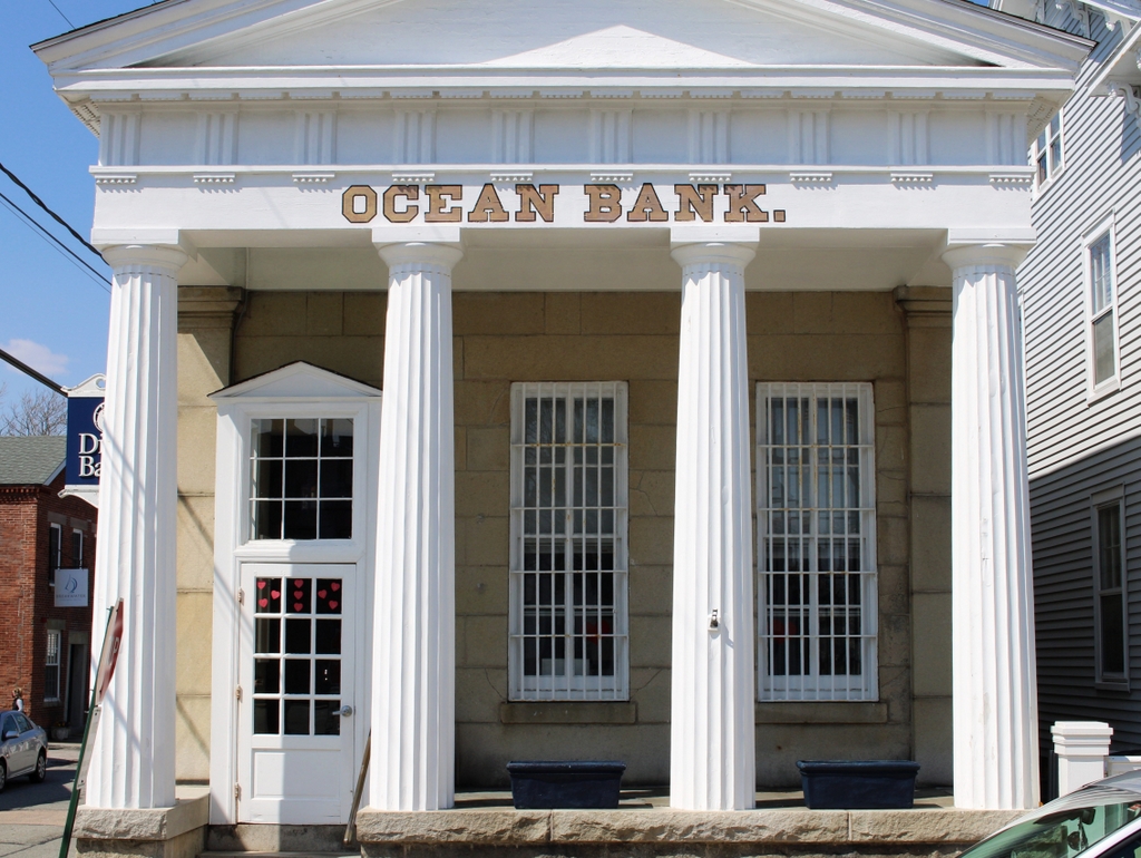
Highland Light, Truro, Mass

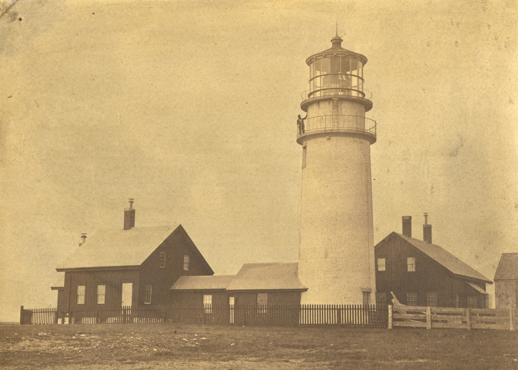
Highland Light, also known as Cape Cod Light, in Truro, Mass, on February 14, 1859. Image courtesy of the National Archives.
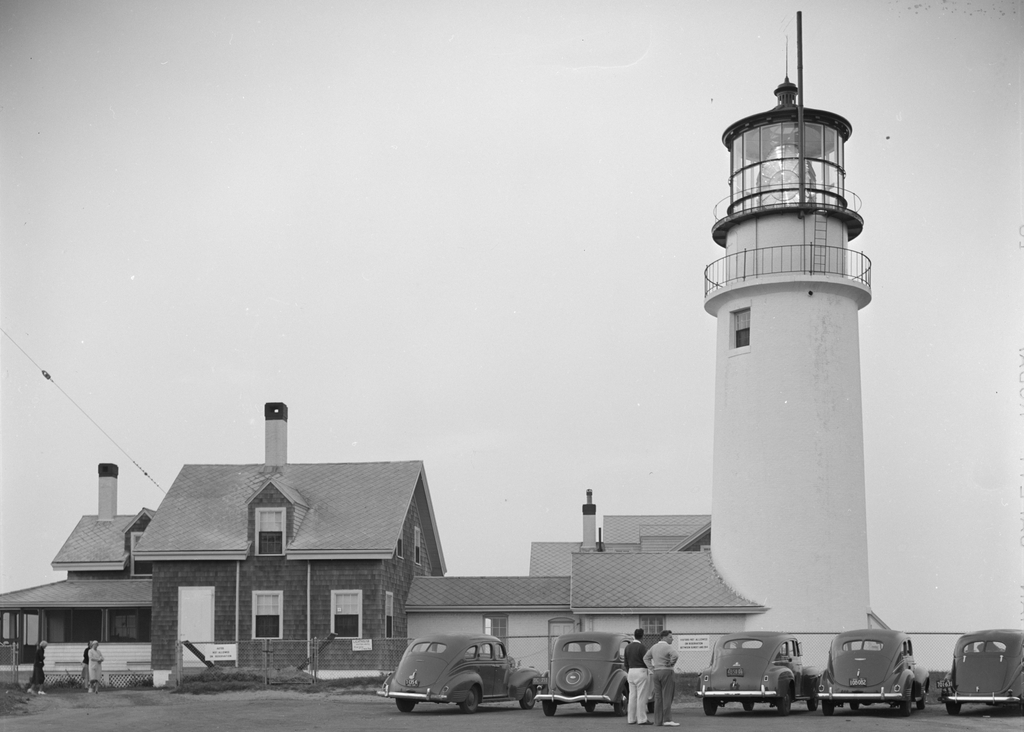
The lighthouse around 1935-1942. Image courtesy of the Library of Congress, FSA/OWI Collection.
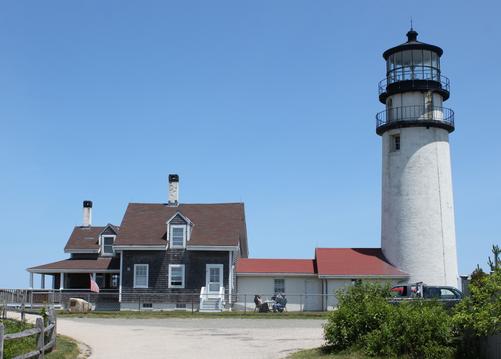
The scene in 2014:
Formed by glaciers at the end of the last ice age, Cape Cod is a long, sandy peninsula on the eastern edge of Massachusetts. It extends outward into the Atlantic Ocean with a hook-like shape that bears resemblance to a flexed arm, and beyond its coastline lies a variety of ever-shifting shoals and sandbars. In the four centuries since European colonization of the area, these attributes have made Cape Cod a significant hazard to navigation, and its shores have been the site of numerous shipwrecks over the years.

The first recorded shipwreck on Cape Cod occurred even before permanent European settlement in the area, when an unknown French ship ran aground sometime around 1617. Many more would follow over the years, including the notorious pirate Samuel “Black Sam” Bellamy, who died 1717 after his ship was wrecked near what is now Marconi Beach in Wellfleet. However, it would be many decades before the first lighthouse was built on Cape Cod to warn mariners away from the treacherous shoreline.

Finally, in 1796, at the behest of a group of Boston merchants, Congress appropriated $8,000 for the construction of the first lighthouse on Cape Cod. The site that was chosen for the lighthouse was here in North Truro, atop the 125-foot cliffs that gave the Highlands area its name. The government purchased ten acres of land, plus a right-of-way, from local resident Isaac Small for $110, and they subsequently hired him as the first keeper of the light, with a salary of $150.

The lighthouse was completed in 1797. It was octagonal in shape and built of wood, and it stood 45 feet tall. It featured a whale oil lantern, and it was evidently the first lighthouse in the country to use an eclipser, which gave it a flashing appearance to distinguish it from Boston Light. Aside from the tower, the light station also included the keeper’s house, a barn, and an oil shed.

The eclipser proved to be unreliable, and the tower itself also had its own problems, with an 1811 report describing it as having been “wretchedly constructed.” Part of the problem was that the tower was too high, so around 1812 it was lowered, and a new lantern was installed atop it. Following these modifications, this lighthouse would remain in service until 1831, when it was replaced by a new 35-foot brick tower.

Like its predecessor, though, the second lighthouse here proved to be similarly deficient in its construction. It was built by Winslow Lewis, a contractor who built many lighthouses along the east coast. However, his works were generally better known for their low costs than for the quality of their construction, and the upper portion of the new lighthouse had to be rebuilt less than a decade later. This part of the project was done by Lewis’s nephew, I. W. P. Lewis, who was by all accounts a far more competent engineer than his uncle.

Despite these improvements, the second tower ultimately proved to be short-lived. It is perhaps most famous as the lighthouse that author Henry David Thoreau visited several times during his visits to Cape Cod in the 1840s and 1850s. He included a chapter on the lighthouse in his book Cape Cod, including an account of how he put his surveying skills to use here and calculated that the cliff was 123 feet above sea level. He also estimated the rate of erosion here, and rather presciently predicted that “erelong, the light-house must be moved.”

Highland Light would ultimately have to be moved, although it would take 140 years before this was necessary, and it was a different lighthouse than the one that Thoreau saw. His last visit to Highland Light occurred in June 1857, and he noted in his journal that “A new lighthouse was built some twenty-five years ago. They are now building another on the same spot.” This lighthouse that he saw under construction was completed later in 1857, and it is the one that is shown here in these three photos.

The new lighthouse was a far more substantial than its two predecessors, standing 66 feet high, with brick walls more than three feet thick at the base. It was equipped with a new French-made Fresnel lens, replacing the 15 Argand lamps and silver-plated reflectors that had illuminated the previous lighthouse. The Fresnel lens cost $30,000, which was twice the cost of constructing the lighthouse itself, and it required a larger crew to maintain. As a result, the one lighthouse keeper here was joined by two assistant keepers. They lived here in two new houses that were connected to the tower by covered walkways. The head keeper lived in the house to the north of the lighthouse, on the left side of this scene, and the assistant keepers lived in the other house, which is visible just beyond the tower in the first two photos.

The first photo was taken less than two years after the new lighthouse was completed. It shows a man, presumably one of the keepers, standing on the lower balcony of the tower. He was probably one of the three keepers listed here in the 1860 census. The head keeper at the time was 55-year-old John Kenney, who lived here with his wife Jane. The first assistant, Hugh Hopkins, was 59, and he lived here with his wife Sarah along with their granddaughter Eliza Knowles and Sarah’s mother Abigail Smith. The second assistant, Thomas Kenney, was the youngest of the three at 50, and his family here included his wife Sarah and their daughters Mary and Elizabeth.

Despite the presence of the lighthouse, shipwrecks continued to occur here along the northeastern shoreline of Cape Cod. During the 19th century there were at least 60 recorded shipwrecks in Truro, many of which were lost with most if not all of their crews. In some cases, multiple ships would be wrecked during a single storm. A snowstorm on December 26, 1872 claimed two sailing vessels, the Peruvian and the Francis, with very different outcomes for the crews. The Peruvian sank with all hands, while the entire crew of the Francis was rescued by volunteers in a whaleboat, although the captain died of an illness several days later. Another deadly storm occurred on January 3, 1878, when 12 sailors died in three different shipwrecks.

The deadliest single shipwreck here in Truro was the Jason, a British sailing ship that was on its way to Boston from Calcutta. The Jason grounded a little north of Ballston Beach, a few miles to the south of Highland Light, during a storm on December 5, 1893. Out of a crew of 25, there was just a single survivor from the wreck. A few years later, these same shores saw the aftermath of one of the deadliest time disasters in New England history, after the passenger steamer Portland was lost off the coast of Cape Ann on November 27, 1898. There were no survivors, and some of the bodies and wreckage washed up here in Truro, despite being about 25 miles from where the ship foundered.

Lighthouse keepers here at Highland Light, as was the case elsewhere, had a variety of responsibilities, including maintaining the lighthouse and other buildings here at the facility. However, their most important duty was to ensure that the light was lit promptly at sunset, remained lit throughout the night, and was extinguished at sunrise. Each of the three keepers worked a shift during the night, with one keeper on duty until 8:00 pm, another from 8:00 to midnight, and then the third from midnight to 4:00 am. Then, at 4:00 the keeper who lit the lamp would return until sunrise.

By the late 19th century, Highland Light was illuminated by a Funck float lamp, which consisted of five concentric wicks of varying diameters. The lighthouse initially burned whale oil, but it later used animal lard and then eventually kerosene. The lamp produced about 500 candlepower of light, which was then greatly amplified by the prisms of the Fresnel lens. The original 1857 lens increased the intensity of the light roughly twentyfold, creating a fixed beam of about 10,000 candlepower. However, by the turn of the 20th century this was insufficient for the needs of maritime traffic, so in 1901 the old lens was replaced by a new first order Fresnel lens. The old lamp was retained, but the new lens further amplified its intensity to about 192,000 candlepower, or nearly 400 times the intensity of the lamp itself. The new lens also rotated, creating a flashing effect that made it much more noticeable at sea than the old fixed lens. A temporary light tower was in use here while the lenses were changed, and the new lens went into use on October 10, 1901.

The second photo was taken around 1940, as shown by the license plates on the cars in the foreground. The massive Fresnel lens is clearly visible in the lantern room, but in 1932 the old oil lamp had been replaced by a thousand-watt electric bulb. This gave the light an intensity of four million candlepower and a range of up to 45 miles, making it one of the most powerful lighthouses in the country. By this point, many American lighthouses had been automated, but Highland Light was still manned by resident keepers. However, this was far from the isolated outpost that Thoreau had visited nearly a century earlier. Automobiles had made the outer parts of the Cape far more accessible than before, and the photo shows a number of tourists here, including two cars from New York and one from Ohio. One sign on the fence indicates that the lighthouse visiting hours are from 10:00 am to noon, and then from 2:00 to 4:00 pm. Another sign advises that the grounds are closed to visitors from sunset until 9:00 am.

The head keeper at the time of the second photo was William A. Joseph. He had served here at Highland Light since the early 1920s, and he held the position of assistant keeper until 1935, when he was promoted to head keeper. By 1940 he was 52 years old, and he lived here with his wife Nellie. That year’s census lists his salary as $1,500, while the two assistant keepers earled $1,320 and $1,260. He remained here until his retirement in 1947, and he appears to have been the last civilian keeper at the lighthouse before the Coast Guard took over the operation of the light station.

Overall, despite being taken more than 80 years apart, the first two photos do not show major changes to the lighthouse or adjacent keepers’ houses. The alterations to the houses were mostly superficial, including the addition of a porch and a dormer window on the head keeper’s house, along with shingles that replaced the earlier vertical boards on the exterior of the houses. The lighthouse itself barely changed in the period between the two photos, aside from the upgraded lens and the addition of some sort of a pipe next to the lantern room.

By contrast, the second and third photos were taken less than 75 years apart, yet they show far more substantial change here at Highland Light. The old Fresnel lens only lasted a few more years after the second photo before being removed in the late 1940s and replaced by an aerobeacon. Then, in 1961 the assistant keepers’ house was demolished, and a new ranch-style duplex was built just to the southeast of the lighthouse. The lighthouse would remain actively staffed by Coast Guard keepers for several more decades after this, but it was ultimately automated in 1986 and a new aerobeacon was subsequently installed.

As lighthouses around the country were automated during the mid to late 20th century, this often led to the deterioration of the keeper’s houses and other associated buildings, which were typically rendered obsolete. However, here at Highland Light it was not just the keeper’s house that was endangered in the late 20th century. By the early 1990s, Thoreau’s prediction that the lighthouse would need to be moved was fast becoming a reality. The 1857 lighthouse was built on the same spot as its predecessors, which had been more than 500 feet from the cliff when the first one was completed in 1797. By the 1990s, though, the ocean’s steady erosion of the sandy cliffs had reduced this distance to just over a hundred feet.

The only real option for saving the lighthouse was to move it, but moving a 66-foot-tall, 450-ton masonry structure is no easy task, especially one that is nearly 140 years old. The lighthouse was first stabilized with a series of vertical two-by-fours that were strapped to the tower with steel wire. Then, 20 steel beams were inserted through the foundation, with two support beams laid perpendicular underneath these beams. These support beams were then slowly pushed along seven parallel roller beams. There were two sets of these roller beams, and the sets were alternated as the lighthouse moved along the beams. It took 18 days to move the lighthouse 450 feet west and 12 feet south of its original location, and the move was completed on July 29, 1996. The keeper’s house was not moved at the same time, but it was later moved and reattached to the lighthouse.

As a result of the move, the 2014 photo was taken a few hundred feet west of where the first two photos were taken, although it faces the same direction and shows the same view of the lighthouse as the other photos. The lighthouse remains an active aid to navigation, standing as both the oldest and tallest on Cape Cod. In the years since this photo was taken, the lighthouse has undergone a major restoration, including repairing the masonry, replacing or repairing corroded metal, installing a new ventilation system, and repainting the exterior. The lighthouse and keeper’s house have been closed to the public during this time, but they are expected to reopen for the upcoming 2022 season.

William Tecumseh Sherman Statue, New York City (2)

The statue William Tecumseh Sherman, in Grand Army Plaza at the corner of Fifth Avenue and 59th Street in New York, in September 1942. Image courtesy of the Library of Congress, Farm Security Administration/Office of War Information Collection.

The statue in 2019:

As discussed in an earlier post, this statue was designed by prominent sculptor Augustus Saint-Gaudens and dedicated in 1903, in honor of General William Tecumseh Sherman, one of the most successful Union generals of the Civil War. The statue features Sherman seated on his horse, Ontario, while being led by the goddess Victory. She wears a laurel crown and is holding a palm frond in her left hand, both of which are classical symbols of victory. The statue stands atop a pink granite base, which was designed by architect Charles Follen McKim.

The first photo in the earlier post was taken only a few years after the statue was dedicated, but the first photo here was taken much later, in September 1942. In the interim, the statue had been moved 15 feet to the west in 1913, and then later in the 1910s it was temporarily removed from the site entirely, in order to make room for subway excavations. It was subsequently returned here by the early 1920s, and it has remained here ever since.

By the time the first photo was taken, America had been involved in World War II for less than a year. The photographer was Marjory Collins, a noted photojournalist and New York native who documented life on the home front as part of the United States Office of War Information. The only obvious clue about the war is the sailor seated on the base of the statue, but Collins likely included the photo as a way of connecting the war to past conflicts in the nation’s history.

In the nearly 80 years since the first photo was taken, the statue has undergone several restorations, including re-gilding the surface, and today it looks essentially the same as it did back then. Much of the background has also remained unchanged during this time. There are newer high-rises on the left side, but the two buildings on the right side of the first photo are still standing. On the far right side is the Metropolitan Club, built in 1893, and just to the left of it is The Pierre, a 41-story luxury hotel that opened in 1930.

Jefferson Memorial, Washington, DC

The Jefferson Memorial in Washington, DC, on April 12, 1943. Image taken by Ann Rosener, courtesy of the Library of Congress, Detroit Publishing Company Collection.

The scene in 2018:

The Jefferson Memorial is, along with the Washington Monument and Lincoln Memorial, one of the three major monuments to prominent United States presidents here in Washington, D.C. It was built on the south side of the Tidal Basin, nearly in line with the White House and the Washington Monument, and its construction was championed by Franklin D. Roosevelt, who admired Jefferson.

The design of the memorial was the work of noted architect John Russell Pope, who was also responsible for the National Archives building and the West Building of the National Gallery of Art. Like these other two buildings, Pope’s designs for the Jefferson Memorial drew heavily from classical architecture, and it features a large columned portico on the front. It bears a particularly strong resemblance to the Pantheon, with its domed rotunda behind the portico.

However, Pope never lived to see the project completed; he died in 1937, two years before the cornerstone was laid. The construction took four years, but it was completed in 1943, in the midst of World War II. The memorial was formally dedicated on April 13, 1943, just one day after the first photo was taken. This was the 200th anniversary of Jefferson’s birth, and the ceremony was attended by Franklin D. Roosevelt, who gave the dedication address.

Today, more than 75 years after the first photo was taken, essentially nothing has changed in this scene except for the size of the trees on either side of the memorial. During this time, the only significant change to the memorial has been the 19-foot statue of Jefferson in the center of the rotunda. This statue, which is not visible from this particular angle, was delayed because of wartime shortages of bronze, but it was installed in 1947, and it has stood here ever since, facing across the Tidal Basin in the direction of the White House.

Washington Monument and Reflecting Pool, Washington, DC

The view of the Washington Monument and the Reflecting Pool, seen from the steps of the Lincoln Memorial in November 1943. Image taken by Esther Bubley, courtesy of the Library of Congress, FSA/OWI Collection.

The scene in 2018:

The first photo was taken in 1943 by Esther Bubley, a noted photographer who was employed by the Office of War Information. Only 22 years old at the time, she spent much of 1943 documenting civilian life on the home front, particularly here in the Washington area. Most of the subjects in her photographs were people, but this is one of the few cityscape photographs in her collection, showing one of Washington’s most iconic views in the midst of World War II. Taken from essentially the same spot where Martin Luther King, Jr. would give his “I Have a Dream” speech 20 years later, the first photo shows the Lincoln Memorial Reflecting Pool, with the Washington Monument beyond it in the center of the scene.

This view is easily recognizable today, but upon close examination there were some differences in 1943. On the left side of the scene were the Main Navy and Munitions Buildings, a group of temporary military buildings that were constructed during World War I. They can be seen in a 1922 photo from a previous post, and they were still in use during World War II, and by this point they had been joined by newer temporary buildings, hidden from view on the right side of the scene. These buildings were constructed in order to accommodate the large numbers of government employees needed for the war effort, and the two complexes were joined by pedestrian bridges that spanned the Reflecting Pool, as seen in the first photo.

The bridges were removed soon after the end of the war, but the “temporary” buildings would remain here for several more decades. The ones on the right were finally demolished in 1964, and the ones on the left in 1970. Both sides of the Reflecting Pool became open parkland, with the left side being developed as Constitution Gardens. Otherwise, this scene has not significantly changed in the 76 years since the first photo was taken, and the only noteworthy addition is the World War II Memorial, located at the far end of the Reflecting Pool. This memorial was dedicated in 2004, on what had previously been the site of the Rainbow Pool, and it honors the Americans who were serving in the war around the same time that the first photo was taken.

Jonathan Mix House, New Haven, Connecticut

The house at 155 Elm Street in New Haven, around 1935-1942. Image courtesy of the Connecticut State Library, WPA Architectural Survey Collection.

The scene in 2018:

This section of Elm Street features a row of three historic houses that date back to the late 18th and early 19th centuries. Furthest in the distance, at the corner of Temple Street, is the brick Ralph Ingersoll House, which was built in 1829. To the left of it is the 1767 John Pierpont House, which is one of the oldest houses in New Haven, and closest to the foreground is the 1799 Jonathan Mix House. Together, these three homes are among the few survivors of Quality Row, a term that was once given to the many fine mansions that lined Elm Street along the northern end of the New Haven Green.

Jonathan Mix, the original owner of the house in the foreground, was a New Haven native who was born in 1753. He served in the American Revolution, and spent time as a prisoner of war on the notorious British prison ship Jersey, before returning to New Haven at the end of the war. He and his wife Anna raised a large family, with ten children who were born between 1778 and 1797, at least one of whom died young. Anna died in 1799 at the age of 40, and the following year Jonathan married his second wife, Elizabeth, with whom he had one child.

This house was evidently built around the time of his second marriage, but it does not seem clear how long Jonathan Mix actually lived here. One Mix family genealogy from 1886 indicates that he “lived in the house on Elm street . . . now occupied by Dr. Carmalt” [175 Elm Street], and that he “built the house now owned by Eli W. Blake” [here at 155 Elm Street]. This probably suggests that Mix lived at present-day 175 Elm Street until around 1799, and then moved into this house upon its completion. However, he would not remain in New Haven for much longer, because in 1808 he relocated to New York, where he died in 1817.

As mentioned in the description from the Mix genealogy, this house was later owned by Eli Whitney Blake. He was a nephew of inventor Eli Whitney, but Blake was also a noted inventor in his own right, with innovations such as a mortise lock and a stone-crushing machine. The latter was a particularly important contribution to 19th century America, because it enabled the construction of paved roads. Blake also had connections to the Mix family, which may have been how he acquired this house. His older brother, Elihu Blake, married Jonathan Mix’s youngest child, Adeline, and one of their children was William Phipps Blake, a prominent geologist who also wrote the 1886 Mix genealogy book.

The 1870 census shows Blake living here with his wife Eliza and their son George. His occupation was listed as “Inventor of the Stone Crusher,” but at the time he was also involved with Blake Brothers, a hardware manufacturing company in the New Haven neighborhood of Westville. Among their many products was an early corkscrew, which had been invented by his brother Philos. By this point, Eli was a fairly wealthy man, and the 1870 census values his real estate at $20,000, plus a personal estate of $10,000, for a net worth equivalent to about $600,000 today.

Eliza died in 1876, and Eli continued to live in this house until his death in 1886, at the age of 91. The house was subsequently owned by his daughter Mary, who lived here with her husband George Bushnell, a Congregationalist minister. He died in 1898, but Mary was still here during the 1900 census. She lived until 1916, but in 1901 she sold the property to the Graduate Club, a New Haven social club that had been founded in 1892.

The first photo was taken sometime in the late 1930s or early 1940s, as part of a WPA survey to document historic buildings across Connecticut. Not much has changed since then, and all three of these historic Elm Street homes are still standing. The other two homes are owned by Yale, but the Jonathan Mix House continues to be used as the clubhouse for the Graduate Club, although the organization was renamed the Elm City Club following a 2012 merger with the Quinnipiack Club.

Ralph Ingersoll House, New Haven, Connecticut

The house at 143 Elm Street, at the corner of Temple Street in New Haven, around 1935-1942. Image courtesy of the Connecticut State Library, WPA Architectural Survey Collection.

The house in 2018:

The north side of the New Haven Green was once known as Quality Row, for the many elegant homes that lined Elm Street. All of the houses along the eastern half of the Green, on the block between Temple and Church Streets, were demolished by the early 20th century, but several survive here on the western half, including this mansion. It was built in 1829 as the home of attorney and politician Ralph I. Ingersoll, and it was designed by Ithiel Town and Alexander Jackson Davis, two prominent architects of the early 20th century.

Ralph Ingersoll came from a prominent family that included his father, Jonathan Ingersoll, who served as lieutenant governor of Connecticut from 1816 to 1823. Ralph would also go on to become a leader in state politics, serving as speaker of the Connecticut House of Representatives from 1824 to 1825. He then served four terms in Congress, from 1825 to 1833. At the time, Connecticut did not have separate Congressional districts, so Ingersoll and the other five representatives were elected at-large by the entire state. From 1830 to 1831, he was simultaneously the mayor of New Haven, and he was later appointed U. S. Minister to Russia, serving from 1846 to 1848. During his time as a congressman, Ingersoll also received a prominent visitor to his home in 1833, when President Andrew Jackson came here during a visit to New Haven.

Ralph Ingersoll and his wife Margaret lived here together for over 40 years, and two of their sons would also go on to have successful political careers. The oldest, Colin, was elected to two terms in the U. S. House from 1851 to 1855, and his brother Charles served as governor of Connecticut from 1873 to 1877. The 1870 census, taken two years before Ralph’s death, shows him living here along with Margaret, their daughter Grace, and three servants. His real estate holdings were valued at $57,000, along with a personal estate of $12,000, for a net worth equivalent to nearly $1.4 million today.

Charles Ingersoll inherited this house from his father, and he lived here during his time as governor. The 1900 census shows him widowed and living here with his sister Grace, his children Justine and Francis, daughter-in-law Lucy, three servants, and a nurse. He remained here until his death in 1903, and the house was subsequently owned by Ingersoll family relative Frank H. Whittemore. He was a physician, and this building served as both his house and his office. His son, E. Reed Whittemore, was also a physician, and he also practiced medicine here with his father.

In 1919, Yale University purchased the house, thanks to a gift of $100,000 from Harriet Williams in memory of her son, Earl Trumbull Williams,. He was a 1910 graduate of Yale, and went on to serve as a lieutenant in the army during World War I. However, in 1918 he was killed by a falling tree while on leave from his post at Camp Devens in Massachusetts. This house became the Earl Trumbull Williams Memorial, and it was initially used to house the Yale University Press.

The first photo was taken several decades later, in the late 1930s or early 1940s. By this point it was still occupied by Yale University Press, which would remain here until 1959. Over the years, the exterior of the house has remained well-preserved – even the two trees in front are still standing from the first photo – and it is still owned by Yale. Today, it is used for offices, and it was recently used as the temporary home of Dwight Hall, a community service organization that was located here while its building was undergoing renovations in 2017-2018.