
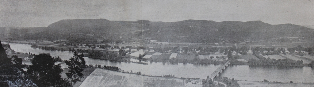
A panoramic view looking east from South Sugarloaf Mountain in Deerfield, toward Mount Toby in Sunderland, around 1891. Image from Picturesque Franklin (1891).
The scene in 2021:

These two photos were not taken from the exact same spot, as shown by the different angles of the bridges in the lower right, but they show the same general view of the Connecticut River, the town of Sunderland, and Mount Toby in the distance. Both were taken from near the summit of South Sugarloaf Mountain, a relatively small hill that forms the southern end of the Pocumtuck Range, which is part of the larger Metacomet Ridge. Sugarloaf is best known for its dramatic views of the valley to the south, but this eastern view is also offers impressive scenery.
South Sugarloaf is often referred to simply as Sugarloaf Mountain, although it is the smaller of the two summits that comprise the mountain. However, the northern peak, while nearly 200 feet higher in elevation, has only limited views from the summit, and is rarely visited. By contrast, the southern peak has long been a popular tourist destination. Rising to an elevation of 610 feet, it is about 500 feet higher than the Connecticut River, which passes just a third of a mile from the summit.
The first photo was likely taken from the Summit House, which was built here in 1864. These types of mountaintop hotels were popular in the northeast during the second half of the 19th century, and several others were located on nearby summits on the Metacomet Ridge, including the Prospect House on Mount Holyoke and the Eyrie House on Mount Nonotuck. Even Mount Toby briefly had a tower and hotel at the summit, but the buildings burned in 1882. This was a common fate for summit houses, given their isolated locations far above water sources, and the summit house on Sugarloaf Mountain would eventually be destroyed by a fire in 1966.
Mount Toby, which towers in the distance beyond the town of Sunderland, is geologically related to Sugarloaf Mountain. It is the highest peak on the Metacomet Ridge, and at 1,269 feet it is more than twice the height of South Sugarloaf. However, as the photos show, the mountain is not a single peak. Its rugged landscape has many different summits, the highest of which is on the northern side, on the far left side of both photos.
The mountain is said to be named for Elnathan Toby, supposedly the first white settler to climb it. In the 19th century, though, the prominent geologist Edward Hitchcock criticized this rather bland name. Hitchcock, who would later serve as president of Amherst College, published a report on the state’s geology in 1841. In it, he included Mount Toby, along with Sugarloaf and a number of other peaks, as part of a list of “uncouth and vulgar names” for Massachusetts mountains. Hitchcock tended to prefer Native American names, and he succeeded in renaming several peaks, including Hilliard’s Knob, which was renamed Mount Norwottuck in a large mountaintop ceremony in 1846. He made a similar attempt on Mount Toby three years later, naming it Mettawompe in honor of the Native American chief who had sold the surrounding land to white settlers. However, unlike Norwottuck, this name didn’t stick, apparently because of local opposition among Sunderland residents, and the mountain has continued to be known as Mount Toby.
Aside from the ill-fated attempts to operate a summit house on Mount Toby during the 19th century, the mountain has remained largely undeveloped, and today it looks essentially the same as it did when the first photo was taken around 1891. The town of Sunderland has also retained much of its rural appearance, and many of the houses along Main Street are still standing, as is the 1836 First Congregational Church, which is visible on the right side of both photos. Another town landmark in this scene is the Buttonball Tree. Although not identifiable from this distance, it stands near the center of the scene in both photos, about a quarter mile north of the church. With a girth of over 25 feet, this sycamore tree is one of the widest trees in the region, and it is estimated to be over 350 years old. Overall, probably the only easily-noticeable difference in these photos is the bridge over the Connecticut River. The one in the first photo was built in 1877, and it spanned the river until 1936, when a bridge further upstream was washed away in a flood and crashed into this bridge.
In the meantime, here on South Sugarloaf, the mountain continues to offer some of the finest mountaintop views in the state. It is now part of the Mount Sugarloaf State Reservation, and there is an auto road to the summit, along with several short hiking trails. In place of the 19th century summit house, the mountain is now topped by an observation tower with several different levels of platforms.