First Church of Christ, Farmington, Connecticut

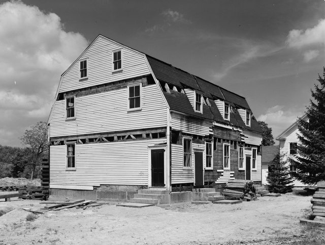
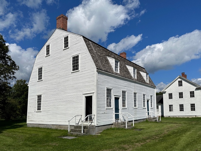
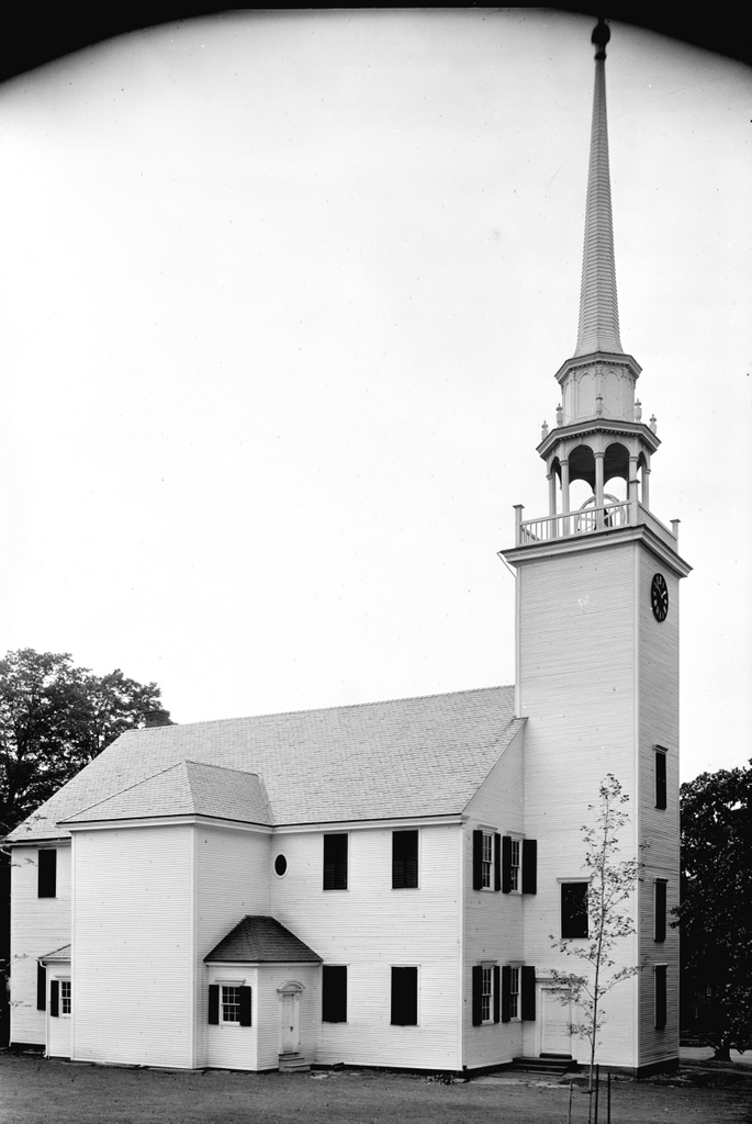
The First Church of Christ, Congregational, on Main Street in Farmington, on July 29, 1940. Image courtesy of the Library of Congress, Historic American Buildings Survey Collection.
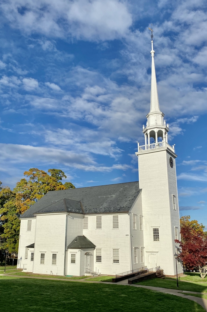
The church in 2021:

Farmington’s First Church of Christ, shown here in these two photos, stands as one of the best surviving examples of a colonial-era meetinghouse in Connecticut. It was completed in 1772, and it was designed and constructed by Judah Woodruff, a local builder who was responsible for many houses in Farmington during this period. As was the case for other meetinghouses of the era, it served as the religious, social, and political center of the town, functioning as a place not only for church services, but also for town meetings and other gatherings.

The church was established in 1652, and it occupied two earlier meetinghouses. The details of the first one are unclear, but the second one was completed in 1714, and it stood here in the vicinity of the present-day structure. This second meetinghouse was small and poorly built, and it had to serve the needs of a growing town. At the time, Farmington was significantly larger geographically, and included present-day towns such as Avon, Berlin, Bristol, Burlington, New Britain, Plainville, and Southington. Many of these places had their own parish churches by the mid-1700s, but their inhabitants still had to come here to Farmington for the town meetings.

By the late 1760s, the town had begun the process of planning for a new meetinghouse, and the construction work began in 1771, as indicated by the “July AD 1771” inscribed on one of the foundation stones. It was completed a little over a year later, and the dedication ceremony occurred on November 25, 1772. The architecture of the building is typical for colonial meetinghouses of its era, with a main entrance on the long side of the building and a steeple that is set off to the side. It would not be until the late 18th century that this trend shifted, and it became more common for meetinghouses to have main entrances on the gabled end of the building, and a steeple that rises from the roof above that entrance.

The interior of the Farmington meeting house likewise reflected colonial-era styles. The pulpit was located in the middle of the long side of the building, so that the interior was much wider than it was long, in contrast to later church designs. On the main floor were a series of box pews that were rented by families, and there were more pews on the gallery, along with rows of benches in front of them. As was the case in most colonial meetinghouses, seating reflected social status, and the more prominent families generally occupied the pews closer to the front, while young unmarried people, along with people of color, were usually in the less desirable seats in the gallery.

When the current meetinghouse was constructed, the pastor of the church was Timothy Pitkin. A 1747 graduate of Yale, Pitkin had subsequently married Temperance Clap, daughter of Yale president Thomas Clap, and then became the pastor here in Farmington in 1752. He came from a prominent Connecticut family; his father, William Pitkin, was the colonial governor from 1766 to 1769, and Timothy’s son, also named Timothy, was in the U.S. House of Representatives from 1805 to 1819. Aside from serving as pastor, Pitkin was also a benefactor of the new meetinghouse; he contributed 20 pounds toward its construction, which was a significant part of his 125 pound annual salary.

The meetinghouse was completed right around the time when Connecticut and the other colonies were dealing with questions relating to British authority. Here in Farmington, residents condemned the so-called Intolerable Acts, which Parliament had passed in response to the Boston Tea Party. At a June 1774 town meeting here, the voters of Farmington declared their opposition to “such arbitrary and tyrannical acts,” and they approved a measure to gather food and transport it to Boston to aid the beleaguered residents there.

Then, in September the town approved the purchase of stockpiles of lead, flints, and powder, and in December it indicated its support for the resolutions of the First Continental Congress. However, not everyone in the town was apparently united in their support. The town records also indicate that, at the December meeting, Matthias Loaming, and Nehemiah Royce were declared to be “Open Enemies to their country” for refusing to vote on the measure. As a result, the town voted to “withdraw all connection from them, untill they shall make Public Retraction of their Principles and Sentiments in the matters aforesaid.”

Once the Revolution started, Farmington supported the Patriot cause. At a town meeting here in March 1777, voters approved a bonus system to encourage residents to enlist in the Continental Army. Soldiers would receive five pounds upon enlistment, followed by another five pounds after completing one year of service. Then, in September the town approved providing two shirts and two pairs of stockings to those who were in the army.

Aside from approving expenditures to fight against British rule, another matter that came up here in the meetinghouse was the need to maintain decorum during worship services. In December 1772, soon after the meetinghouse opened, the town addressed the issue. As quoted in Noah Porter’s 1872 Historical Discourse on the church, the complaint was that:

[I]t is suggested by many members of this society that indecencies are practiced by the young people upon the Sabbath in time of public worship by frequently passing and repassing by one another in the galleries, and intermingling sexes to the great disturbance of many serious and well minded people.

Naturally, such scandalous behavior as unmarried people sitting with members of the opposite sex could not be tolerated here, so the town designated separate gallery staircases for men and women. However, it does not seem to have had the desired effect, because it was still an issue over 40 years later when, in a similar issue was raised in 1813. As quoted by Porter, the church declared:

that the practice of certain young gentlemen in themselves in the pews on the female side of the gallery in times of public worship is disorderly, and ought to be, and is, by this society, wholly disapproved of.

This issue was eventually resolved in the mid-1820s, when the pews in the galleries were replaced with slip pews, and young people were encouraged to sit with their families, rather than being largely unsupervised in the galleries. The old pews on the main floor were later replaced in 1836, and around this same time the original high pulpit was also removed. Another sign of changing times came in 1824, when the first stoves were installed. Prior to this time, as was typical for colonial-era meetinghouses, people would have to bring their own foot stoves if they wanted heat.

Perhaps the single most notable event in the history of this building is its involvement in the Amistad case. Farmington was one stop in the long odyssey of the survivors from La Amistad, as they traveled from Africa to Cuba to Connecticut, before ultimately returning to Africa. It began when a group of Mende people from Sierra Leone were captured and transported to Cuba. From there, 53 of them were sold in Havana and then transported on the schooner La Amistad. During this trip the Mendes, led by Cinqué, overpowered the small crew, killed the captain and cook, and forced the others to sail to Africa. However, the navigators deliberately kept the ship off course, and it was intercepted by U.S. authorities off the coast of New York City in August 1839.

This incident occurred in the midst of rising tensions in the United States surrounding the future of slavery, and it led to several important questions that the courts had to address. These included the issues of whether or not the Mendes had been legally enslaved, since the international slave trade was illegal in the United States, and also whether or not their mutiny had been a justifiable act of self defense. President Martin Van Buren, under pressure from Spanish authorities and from southern slave owners, favored returning them to Cuba. They were ultimately put on trial in Connecticut, with two different court cases in Hartford and New Haven. The court found in their favor, but the Van Buren administration appealed it to the Supreme Court, which upheld the lower court’s ruling in 1841.

With this decision, the Mendes were free, but they still had to get back home. They would end up spending much of 1841 in Farmington, where the abolitionist-minded community provided them with places to live while also working to raise money for their return trip to Africa. There were 36 survivors by the time they arrived in Farmington, with the rest having died at sea or while in prison. One more, a man named Foone, drowned while swimming in the Farmington Canal in August, but the other 35 remained here until November. Throughout this time, they regularly attended church services here in this building.

The town held a farewell service for them on November 17, here in the meetinghouse. The Reverend Joel Hawes of the First Church in Hartford preached a sermon for the occasion, based on the verse “And hath made of one blood all nations of men, for to dwell on all the face of the earth” from Acts 17:26. In his sermon, Hawes praised African culture, denounced the effects of slavery on the people of Africa, emphasized the sinfulness of racism, and reminded Christians about how all humans are a part of the same family. After the sermon, several of the Mendes spoke and sang, and then Cinqué delivered a narrative of their captivity. He spoke in his native language, and one of the other Amistad captives, Kinna, translated it into English for the crowd. They departed Farmington two days later on a canal boat, headed for New York. There, they attended another farewell service, and then boarded a ship to Sierra Leone, where they arrived in 1842.

In the years that followed, the old meetinghouse continued to stand here in the center of Farmington as an important town landmark. After 1830 it was no longer used for town meetings, a move that reflected changing attitudes surrounding the relationship between church and state, but it continued to be used by the First Church for its worship services. By the time the first photo was taken in 1940, the building was nearly 170 years old, yet its exterior had largely retained its architectural integrity.

Today, the First Church is still an active church congregation, and this building stands as a well-preserved example of a colonial-era New England meetinghouse. From this angle, there have been few changes aside from the addition of several windows and the removal of the shutters. These shutters would not have been original to the building, so they were probably removed in order to reflect its 18th century appearance. In 1972, the building was named as a contributing property in the Farmington Historic District, and then in 1975 it was individually designated as a National Historic Landmark.

Confederate Dead at Dunker Church, Sharpsburg, Maryland

Bodies of Confederate soldiers in front of the Dunker Church in the aftermath of the Battle of Antietam, photographed in September 1862 by Alexander Gardner. Image courtesy of the Library of Congress, Civil War Glass Negatives and Related Prints collection.

The scene in 2021:

The first photo is one of the most iconic images from the Civil War, showing the aftermath of the Battle of Antietam. It was taken by renowned war photographer Alexander Gardner, who captured a small glimpse of the deadliest single-day battle in American history. In the foreground are dead Confederate soldiers lined up in front of an artillery limber, with a dead horse beneath the cart. An assortment of debris is scattered around the field, including a pair of shoes in the lower right side of the scene. Further in the distance is the Dunker Church, with whitewashed walls that bear the scars that the battle had inflicted two days earlier.

The Battle of Antietam was fought on September 17, 1862, between Union forces led by General George B. McClellan and Confederates led by General Robert E. Lee. It was part of Lee’s first major offensive campaign into northern territory, which was undertaken with the hopes of undermining northern morale and support for the war. After a series of smaller battles in the area, Lee took a defensive position here at Sharpsburg, Maryland. The left flank of his army was located here in this scene, in the area around the Dunker Church, and it was here that Union forces launched their attack early in the morning of the battle.

The Dunker Church had been built in 1852 as the meeting house of the German Baptist Brethren. One of the core teachings of this Christian denomination was pacifism, but ironically their church would become the scene of some of the fiercest fighting of the battle. Because of its visibility on the battlefield, Union forces used the church as a landmark to focus their attacks. Throughout the morning, the ground near the church frequently changed hands, with both sides sustaining heavy casualties without making significant progress. Over the course of the battle, the fighting eventually shifted further to the south, but not before leaving the area around the church “literally carpeted with dead and dying men,” as Confederate General Thomas “Stonewall” Jackson would later describe it.

By the end of the day, over 2,000 Union soldiers were dead and nearly 10,000 wounded, along with 1,500 Confederates dead and over 7,7000 wounded, making it the bloodiest day in the history of the American military. From a tactical perspective it was essentially a draw, but it was a strategic victory for the Union, since it forced Lee to abandon his invasion plans and return south to Virginia. However, the victorious McClellan faced heavy criticism. Despite having significantly more soldiers than Lee, McClellan failed to exploit this advantage during the battle, nor did he pursue Lee’s vulnerable army during their retreat to Virginia. This was characteristic of McClellan’s overly cautious methods, and it ultimately led to his dismissal by Abraham Lincoln on November 5.

In the meantime, the aftermath of the battle was extensively documented by photographers such as Alexander Gardner. The Civil War was the first major American conflict to be photographed, enabling the general public to see, for the first time, the harsh realities of war. Gardner arrived at Antietam two days later on September 19, and he spent the next few days photographing the battlefield, including scenes of dead soldiers scattered along roads and in fields. He took several different photographs of this scene in front of the Dunker Church, and it became one of his most memorable photographs of the war, perhaps because of the stark contrast between the white church in the background and the carnage in the foreground.

Following the battle, the church was repaired, as shown in the photograph in the previous post, which was taken by Alexander Gardner’s younger brother James at the end of the war. It remained in use as a church until 1899, but it subsequently fell into disrepair, in part because of souvenir hunters who damaged the vacant building by removing bricks from the walls. It ultimately collapsed in a windstorm in 1921, and the site eventually became a gas station, lunch counter, and souvenir shop.

In 1951, the Washington County Historical Society purchased the property, and then gave it to the National Park Service. It became part of the Antietam National Battlefield, and a replica church was reconstructed here on the original foundation in 1962, as part of the centennial of the battle. It still stands today, as shown in the 2021 photo, and it remains one of the most distinctive landmarks on the battlefield. Where the dead Confederate soldiers once rested is now a row of cannons, representing the Confederate artillery position here at this location. In the distant center, in front of the church, is a monument to the 5th, 7th, and 66th Ohio Infantry Regiments, which was dedicated here in 1903. Overall, the Antietam battlefield is one of the best-preserved of all the Civil War battlefields, and this scene is easily recognizable from the first photo, some 160 years later.

Dunker Church, Sharpsburg, Maryland

The Dunker Church near Sharpsburg, Maryland, around 1862-1865. Photo by James Gardner, courtesy of the Library of Congress, Civil War Glass Negatives and Related Prints collection.

The church in 2021:

The first photo was taken by James Gardner, and it was published in 1865 in his brother Alexander’s Photographic Sketch Book of the War. It shows the Dunker Church, which had been a major landmark during the Battle of Antietam on September 17, 1862. The original church survived the battle only to be destroyed by a windstorm in 1921, but a replica was later built on the same site, as shown in the present-day scene.

The church was built in 1852 for the German Baptist Brethren, who were also known as the “Dunkers” because of their practice of baptism by immersion. Their beliefs were related to other Anabaptist churches like the Amish and the Mennonites, and one of their core values was pacifism. In light of that, it is particularly ironic that their meeting house here would become a focal point in the bloodiest single-day battle in American history.

The Battle of Antietam was the culmination of the first major Confederate offensive campaign into Union territory. Emboldened by recent victories such as the Second Battle of Bull Run, Robert E. Lee hoped to bring the war to the north. In doing so, one of his goals was to weaken the northern morale and their willingness to fight the war. To that end, Lee marched northwest from Virginia into Maryland. Along the way, he fought battles at Harpers Ferry, South Mountain, and Crampton’s Gap, before ending up in Sharpsburg, Maryland. There, he took a defensive position just outside of the town, with his left flank positioned here in the vicinity of the Dunker Church.

The battle began early in the morning of September 17, with a Union assault on the left flank led by General Joseph Hooker. Because of its visibility on the battlefield and its location in the midst of the Confederate defenses, the church became the focal point of the Union attack. However, despite having a small numerical advantage, Union soldiers made little progress in their advance, leading to a particularly bloody scene in a corn field about a half mile to the north of the church, where both sides suffered heavy casualties.

Reflecting on the events of the battle, Confederate General Thomas “Stonewall” Jackson described the scene here, writing:

The carnage on both sides was terrific. The hottest fight seemed to center about Dunker Church, where there were no less than four charges and counter-charges. Each army had taken and retaken the ground until it was literally carpeted with dead and dying men.

Over the course of the morning, the battle shifted away from the church. Much of the fighting in the middle stages of the battle centered around the “sunken road” to the southeast of the church, and later in the day the fighting was even further south, in the vicinity of Burnside’s Bridge. Throughout this, neither side made significant progress. The fighting was over by early evening, leaving over 2,000 Union soldiers dead and nearly 10,000 wounded, compared to 1,500 Confederates killed and over 7,700 wounded.

Although both sides suffered similar losses, the Battle of Antietam is generally regarded as an important strategic victory for the Union. In the aftermath of the battle, General Lee abandoned his attempts to invade the north, and instead brought his army back to Virginia. He would eventually attempt one more large-scale invasion of the north less than a year later, but he suffered an even more decisive loss at Gettysburg in July 1863.

In the meantime, the Dunker Church sustained significant damage during the battle, from bullets as well as artillery fire. Photographs taken in the immediate aftermath show a number of holes in the roof and in the brick walls. However, this damage was soon repaired, and the church was back in use by 1864. The first photo was taken about a year later, showing the exterior of the repaired building. The photo was taken by James Gardner, the younger brother of prominent Civil War photographer Alexander Gardner, and it was published in Gardner’s Photographic Sketchbook of the War after the end of the war.

Following the war, the church continued to be one of the most important symbols of the battle, but it also continued to be used as a church until 1899, when the congregation moved to a new building. Now vacant, the old building deteriorated over the next few decades, assisted by souvenir hunters who helped themselves to bricks from the walls. In the end, the humble brick church that had survived one of the deadliest battles of the Civil War was destroyed by a windstorm in 1921.

The site of the church later became a gas station, lunch counter, and souvenir stand, but in 1951 the property was purchased by the Washington County Historical Society and then transferred to the National Park Service. It became part of the Antietam National Battlefield, and in 1962 the church was reconstructed on the original foundation as part of the centennial of the battle.

Today, despite the church being a modern reconstruction with very little original material, this scene still has largely the same appearance as it had in the 1860s. Antietam is one of the best-preserved Civil War battlefields, and the reconstructed church remains one of its most distinctive landmarks. The building is open to the public, and its design is based on what the interior of the original church would have looked like in 1862.

King’s Chapel Burying Ground, Boston

The scene in the King’s Chapel Burying Ground in Boston, around the 1920s. Image courtesy of the Boston Public Library.

The scene in 2021:

King’s Chapel Burying Ground is the oldest cemetery in Boston, dating back to the very beginning of the European colonization of the area. According to tradition, the first burial here was Isaac Johnson, one of the wealthiest and most influential of the original settlers of the Massachusetts Bay Colony. He had extensive landholdings, but he died in September 1630, only a few months after his arrival in the New World. As the story goes, Johnson was buried on his property in Boston, and as other people died in the coming months and years, they were likewise buried here.

In reality, there is no contemporary evidence to indicate that Johnson was even buried in Boston, let alone in this specific plot of land. The earliest account of this story was written nearly 50 years after the fact, in the diary of Judge Samuel Sewall. But, one way or another, this site became a burial ground very early in Boston’s history, although the exact date is uncertain. It would remain the town’s only cemetery until 1659, when Copp’s Hill Burying Ground was established in the North End.

There are no surviving gravestones from the early burials here. The oldest is dated 1658, for William Paddy, although this stone had an interesting history. Paddy was presumably buried here at King’s Chapel, but the gravestone itself was discovered buried under the street next to the Old State House in 1830. It seems highly unlikely that Paddy would have been buried there, and there were no human remains in the vicinity, so the stone was probably removed from the burying ground at some point, perhaps in the 1700s, and repurposed as something else. In any case, it was safely returned here after its discovery in 1830, and has remained here ever since.

Gravestones became more common here during the late 1600s and early 1700s, often with highly ornate, intricate carvings decorated with images of skulls and other symbols of death. Perhaps most notable among them is the gravestone of Joseph Tapping, a large slate stone that stands at the entrance to the graveyard. It is dated 1678, and it features a scroll pediment at the top, and beneath it is a large hourglass atop a winged skull. Beneath the skull is a striking image of a skeleton, likely symbolizing death, trying to extinguish a candle while Father Time tries to restrain him. Another notable gravestone is that of Elizabeth Pain, dated 1704. It likewise features a skull and hourglass, but it also has a large coat of arms carved into it. This design somewhat resembles a capital “A,” which has led some to speculate that this gravestone inspired Nathaniel Hawthorne to write The Scarlet Letter.

In the meantime, in 1688 King’s Chapel was built on the southern portion of the graveyard. It was the first Anglican church in a town that was otherwise dominated by Puritanism, and this was the only land that the church officials were able to acquire. It was originally built of wood, although it was later rebuilt with stone in 1754, as shown in these two photos. The church was not at all affiliated with the graveyard, but, because of its proximity, it came to be known as King’s Chapel Burying Ground, and the name has stuck ever since.

The graveyard continued to be used throughout the 18th and into the early 19th centuries. However, by that point Boston was growing rapidly, and the old burial grounds such as this one were becoming overcrowded and, in the minds of many, posed health risks. So, in 1831 the Mount Auburn Cemetery was established in Cambridge and Watertown, in the suburbs of Boston. In contrast to the crowded, urban setting here, this new cemetery would be laid out like a rural park. And, while the old graveyards featured gravestones with grim, Puritan-era reminders of death, Mount Auburn would have monuments that were generally more neoclassical in style.

By the time the first photo was taken around the 1920s, King’s Chapel Burying Ground had not been used as an active cemetery for many decades. And, in the meantime, many of the old gravestones had been rearranged during the 19th century, evidently to create more orderly rows of stones. As a result, the location of many of the stones no longer corresponded to the site of the remains that they were intended to mark. This practice continued after the first photo was taken, and today the arrangement of the stones is very different from a century ago, as shown in the present-day photo.

Today, King’s Chapel Burying ground is a popular stop on the Freedom Trail, and a nice summer day will find many tourists circulating through the old graveyard. None of the particularly famous gravestones are readily visible in this scene, although the obelisk in the center of the photo stands out amid the otherwise relatively small colonial-era stones. It marks the gravesite of Thomas Dawes, a builder and architect who was also a militia colonel during the American Revolution. Just beyond the obelisk is a tomb that was long believed to have been the final resting place of William Dawes Jr., Thomas’s cousin. He had been one of the riders who, along with Paul Revere, warned of the advancing British redcoats before the Battles of Lexington and Concord. However, it appears that he is actually buried at the Forest Hills Cemetery in Jamaica Plain.

Aside from the graveyard itself, a few of the surrounding buildings are still standing from the first photo. Most notably is King’s Chapel itself, which remains an active church, although it has been a Unitarian congregation—rather than Anglican—ever since the end of the American Revolution. Further in the distance, on the right side of the scene, the other survivor from the first photo is the Tremont Building. Constructed in 1895, this office building still stands at the southwest corner of Tremont and Beacon Streets, and it is currently part of the Suffolk University campus.

Bigelow Chapel, Watertown, Mass

The Bigelow Chapel at Mount Auburn Cemetery in Watertown, around 1865-1885. Image courtesy of the New York Public Library.

The scene in 2021:

As explained in an earlier post, Mount Auburn Cemetery was established in 1831 as an alternative to the small, overcrowded colonial-era burial grounds in the center of Boston. By contrast, Mount Auburn cemetery was to feature winding paths, careful landscaping, and other features that made it not only a quiet final resting place for the dead, but also a pleasant place for the living to visit.

One of the leading figures in creating and subsequently managing the cemetery was Dr. Jacob Bigelow, a physician from Boston. He was involved in the cemetery throughout its early history, including the process of designing and building a chapel here in the cemetery. Working with noted architect Gridley J. F. Bryant, Dr. Bigelow helped to design the chapel. It featured a Gothic Revival design, which was particularly popular for churches and public buildings during this period, and it was completed in 1846.

However, problems soon emerged with the chapel. The contractors had submitted a bid of $19,623 for the project, but they evidently discovered, partway through construction, that this was too low. As a result, they hired less reputable subcontractors to do some of the work, with predictable results. The most significant problem was with the stonework. They used many poor-quality stones, and many of these were not cut to the proper dimensions, which allowed water to enter between the stones. Repeated freeze-thaw cycles in the winter months soon resulted in cracks in the stones, which threatened the structural integrity of the chapel.

To fix the problem, the building had to be demolished and reconstructed, with new stones to replace the defective ones. The work was completed in 1856, resulting in a building that looked essentially the same as the original one. The first photo was probably taken within a decade or two after this, showing a large gathering in front of the main entrance to the chapel.  It would remain in use as the cemetery’s chapel until 1898, when a larger one, which was later named the Story Chapel, opened at the main entrance to the cemetery.

The older chapel, which was formally named in honor of Jacob Bigelow in 1936, then became a crematorium. It was the first of its kind in the state, and is first cremation was in 1900. Since then, the interior has been significantly renovated several times, and the building was expanded with an addition in 1970. This wing now houses the crematorium, and the old chapel continues to be used as a meeting space for various events. Overall, despite these many changes, the view of the chapel from this angle has remained largely unchanged since the first photo was taken, and it stands as an excellent example of Gothic Revival architecture.

Middle Street, Hadley, Mass

The view looking north on Middle Street towards Russell Street in Hadley, around 1900. Image from History of Hadley (1905).

The scene in 2021:

Hadley is one of the oldest towns in western Massachusetts, having been first settled by European colonists in 1659 and incorporated as a town two years later. Its terrain is mostly flat, and it is situated on the inside of a broad curve in the Connecticut River, giving it some of the finest farmland in New England. The main settlement developed in this vicinity, with a broad town common on what is now West Street. This common was the town center during the colonial period, and it was the site of three successive meetinghouses beginning in 1670.

The third meetinghouse, which is shown here in these photos, was completed on the town common in 1808. This location was a matter of serious contention, as by the turn of the 19th century much of the town’s development had shifted east toward what is now Middle Street. Tradition ultimately prevailed, and the third meetinghouse was built on the common. However, this proved to be only temporary, because in 1841 it was relocated. The intended location was to be a compromise, located halfway between the common and Middle Street, but the movers ignored this and brought the building all the way to Middle Street, to its current location just south of Route 9.

Architecturally, this meetinghouse reflects some of the changes that were occurring in New England church designs. Prior to the late 18th century, the region’s churches tended to be plain in appearance. Many did not have steeples, and those steeples that did exist tended to rise from the ground level on the side of the building, rather than being fully incorporated into the main section of the church. This began to change with prominent architects like Charles Bulfinch, who drew inspiration from classical architecture when designing churches and other buildings. Bulfinch’s churches tended to feature a triangular pediment above the main entrance, with a steeple that rose from above the pediment, rather than from the ground.

Bulfinch does not appear to have played a hand in designing Hadley’s church, but its builder was clearly influenced by his works. It has a pediment with a steeple above it, and it also has a fanlight above the front door, and a Palladian window on the second floor. Other classically-inspired decorative elements include pilasters flanking the front entrance and dentils around the pediment. As for the steeple itself, it does not bear strong resemblance to the ones that Bulfinch designed, but the builder likely took inspiration from other 18th century New England churches. In particular, it bears a strong resemblance the steeples of churches such as Old North Church in Boston and the First Church of Christ in Wethersfield, Connecticut.

Aside from moving the church to this site, the other major event of 1841 that solidified Middle Street as the town center was the construction of a town hall here. Prior to this point, town meetings were held in the church, as was the case in most Massachusetts towns in the 18th and early 19th centuries. Massachusetts was slow to create a separation between church and state, and not until 1833 did the state outlaw the practice of taxing residents to support local churches. Here in Hadley, this soon led to a physical separation between the church and the town government, although as shown in this scene the two buildings stood side-by-side on Middle Street.

While the church features Bulfinch-inspired architecture, the design of the town hall reflects the Greek Revival style of the mid-19th century. This style was particularly popular for government and other institutional buildings of the period, as it reflected the democratic ideals of ancient Greece. The town hall is perhaps Hadley’s finest example of this style, with a large portico supported by four Doric columns, along with Doric pilasters in between the window bays on all four sides of the building.

The first photo shows Middle Street around the turn of the 20th century, looking north toward the church, the town hall, and Russell Street further in the distance. The photo also shows a house on the foreground, just to the right of the church. Based on its architecture, this house likely dated back to about the mid-18th century, but it was gone by 1903, when the current house was built on the site. This house was originally the home of Dr. Frank Smith, and it was designed by Springfield architect Guy Kirkham.

Today, the town of Hadley is significantly larger than it was when the first photo was taken more than 120 years ago. Russell Street is now Route 9, a major east-west thoroughfare that has significant commercial development thanks to Hadley’s position at the center of the Five Colleges region. Likewise, Middle Street is far from the dirt road in the first photo, and it is now Route 47. However, much of Hadley has retained its historic appearance, including its extensive farmland and its many historic buildings. Here on Middle Street, both the church and the town hall are still standing. They have seen few major exterior changes during this time, and the church is still an active congregation, while the town hall remains the seat of Hadley’s town government. Both buildings are now part of the Hadley Center Historic District, which was added to the National Register of Historic Places in 1977.