
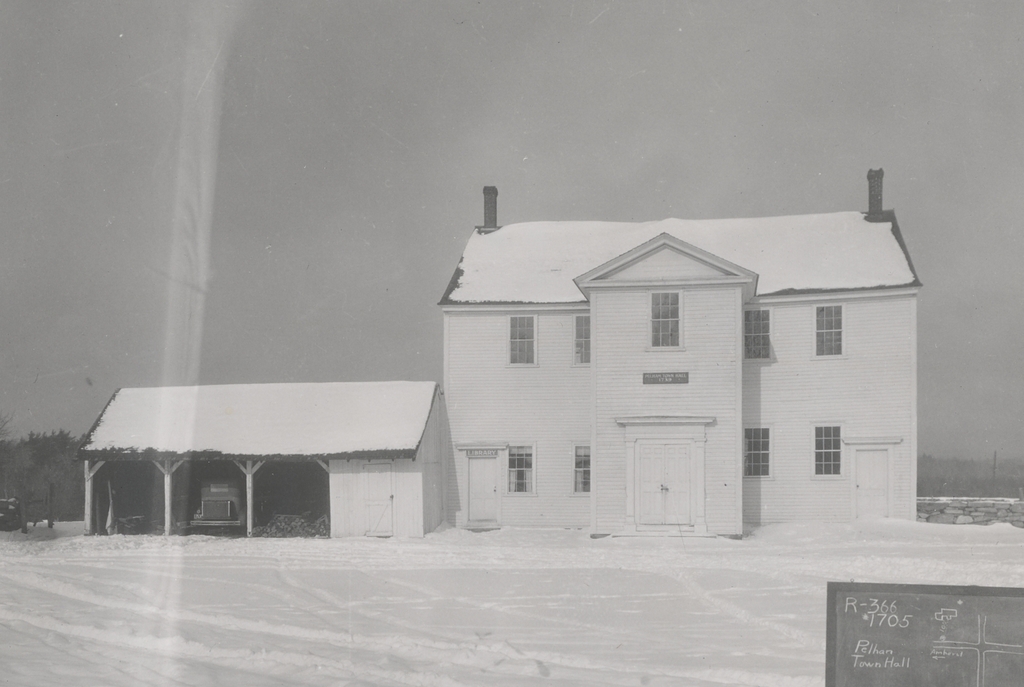
Pelham Town Hall, at the corner of Amherst Road and Route 202 in Pelham, on December 20, 1932. Image taken by Stuart D. Pike, Metropolitan District Water Supply Commission.
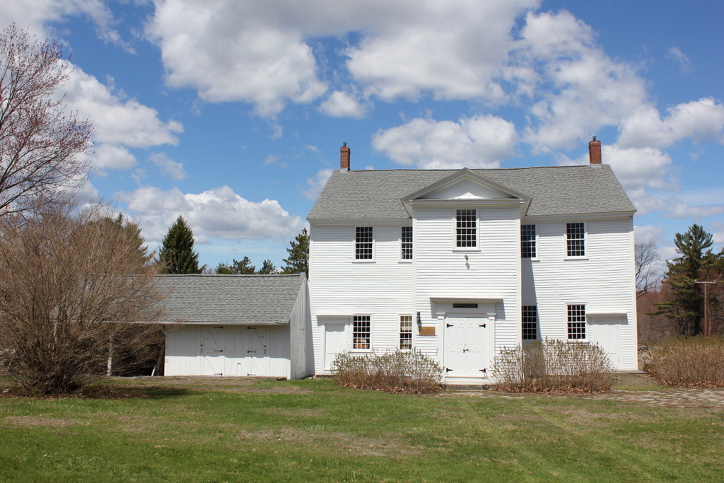
The scene in 2015:
The old town hall here in Pelham was built around 1743, the same year that Pelham was incorporated as a town, and it is said to be the oldest continuously-used town hall in the country. Built long before the idea of separation of church and state, it was also used as the town church for nearly a century, making it one of the oldest surviving church buildings in the state.
Pelham was settled 1739 by Scotch-Irish colonists. Most had been part of a group of immigrants who arrived in Boston in 1718, but they faced discrimination in the largely English Puritan town, and many subsequently moved to Worcester. However, they received similar treatment there, and by the 1730s they began looking west to what was, at the time, the frontier areas of Massachusetts.
In 1738, a group of 34 settlers purchased the land that would become Pelham from Colonel John Stoddard of Northampton. They then laid out house lots and roads, and within a few years they began construction of this meeting house here at the crest of a hill near the geographic center of town. The town hired brothers Thomas and John Dick to build it, and it may have been used for church services as early as 1741, although the entire structure was not completed until 1746.
Pelham was incorporated as a town in January 1743, and the first town meeting occurred here in this building a few months later on April 19. Among the items of business was the selection of town officials. These included five selectmen, a town clerk, and a treasurer, along with a variety of other offices, including two fence viewers, two hog reeves, and two “Officers to Prosecute ye Law Respecting Killing Deer,” which was apparently an 18th century equivalent of a game warden.
With the town government established, the next step was for the town to choose a pastor. During its first few years, the church did not have its own pastor. Instead, the weekly preaching was handled by “suppliers,” who were generally short-term itinerant pastors. One such supplier was Robert Abercrombie, a Presbyterian pastor who began preaching here as early as 1742. A native of Scotland, Abercrombie graduated from the University of Edinburgh and subsequently came to the American colonies, arriving in 1740.
In May 1743, the town selected three residents who would be responsible for consulting with other local clergymen and choosing an appropriate person to become the town’s full-time pastor. This committee subsequently recommended Abercrombie, and four other pastors submitted a letter endorsing him, including Jonathan Edwards, the prominent theologian and pastor of the church in Northampton. The letter read:
Whereas we ye Subscribers have had some considerable acquaintance with Rev. Mr. Abercrombie, Preacher of ye Gospel, and what we know of his qualification by Information and personal acquaintance, we advise ye people of God in Pelham to Invite ye sd Mr. Robert Abercrombie to settle in ye Work of ye Ministrie among them as their Pastor.
This letter was dated August 30, 1743, but the next day a group of 22 residents submitted a letter of their own, stating that they “Do protest against ye proceedings of Part of ye inhabitants of ye sd town in their calling of ye Rev. Robert Abercrombie to be their minister in sd town.” The specific reasons for their objections are unclear, but they succeeded in postponing a final decision until the following March. By that point, the opposition evidently relented, and the town extended a formal call to Abercrombie, which he accepted on March 5, 1744.
Abercrombie was ordained here on August 30, 1744, with Jonathan Edwards delivering the sermon for the occasion. Edwards is often remembered for his vivid metaphors describing sin and damnation that he employed in his famous 1741 sermon “Sinners in the Hands of an Angry God,” but his message here in Pelham lacked the same level of intense imagery. He did, however, twice warn his audience here to “fly from the wrath to come,” a phrase that he had used in the closing part of his 1741 sermon.
Edwards’s sermon for Abercrombie’s ordination was titled “The True Excellency of a Minister of the Gospel,” based on John 5:35, “He was a burning and a shining Light.—” He used this verse to explain the role of pastors, and how they are to be a shining light to their congregation, just as John the Baptist was in this particular verse. The printed version of the sermon is nearly 9,000 words long, and likely would have taken around an hour to deliver. The first three-quarters of the sermon focused on the biblical responsibilities of pastors in general, including a grim warning about how pastors who are unfaithful in their positions will suffer torment in hell that is second only to the punishment of demons themselves.
Near the end of his sermon, Edwards turned his attention to Abercrombie. To the new pastor he declared:
You have now, dear Sir, heard something of the Nature and Design of that Office to which you are this Day, in the Name of Christ, to be solemnly set apart. You are therein called to be a Light to the Souls of Men, a Lamp in God’s Temple, and a Star in the spiritual World. And you have heard wherein, in Christ’s Esteem, consists the proper Excellency of one in that Office, and how in this a Minister of the Gospel becomes like his glorious Master, and glorifies him, and is likely to be the Instrument of the Salvation and Happiness of the Souls of Men, and to receive a glorious Reward from the Hands of God. . . .
God in his Providence has brought you far from your native Land, and from your Friends and Acquaintance there; but you will have Reason notwithstanding to acknowledge the good Hand of his Providence towards you, if he is pleased to make you a burning and shining Light in this Part of his Church, and by the Influence of your Light and Heat (or rather by his divine Influence, with your Ministry) to cause this Wilderness to bud and blossom as the Rose, and give it the Excellency of Carmel and Sharon, and to cause you to shine in the midst of this People with warm and lightsome, quickening and comforting Beams, causing their Souls to flourish, rejoice and bear Fruit, like a Garden of pleasant Fruits, under the Beams of the Sun.
Edwards then concluded by speaking directly to the people of Pelham, encouraging them to pray for and support Abercrombie:
If it be, as you have heard, the proper Excellency of a Minister of the Gospel to be a burning and a shining Light, then it is your Duty earnestly to pray for your Minister that he may be filled with Divine Light, and with the Power of the Holy Ghost, to make him so. For herein you will but pray for the greatest Benefit to your selves; for if your Minister burns and shines, it will be for your Light and Life. That which has been spoken of, as it is the chief Excellency of a Minister, for it renders a Minister the greatest Blessing of any Thing in the World that ever God bestows on a People.
Likely aware of the controversy that had divided the congregation a year earlier, Edwards then warned the residents of Pelham to not act in opposition to Abercrombie, and even implied that such people did so because the light of his teachings exposed their own personal sins:
[T]ake Heed that instead of this you don’t take a Course to obscure and extinguish the Light that would shine among you, & to smother and suppress the Flame, by casting Dirt upon it; by necessitating your Minister by your Penuriousness towards him, to be envolved in worldly Care; and by discouraging his Heart by Disrespect and Unkindness. And particularly when your Minister shews himself to be a burning Light by burning with a proper Zeal against any Wickedness that may be breaking out amongst his People & manifests it by bearing a proper Testimony against it in the Preaching of the Word or by a faithful Exercise of the Discipline of God’s House, instead of taking it thankfully, and yielding to him in it, as you ought, don’t raise another Fire of a contrary Nature, against it, viz. the Fire of your unhallowed Passions, reflecting upon and reproaching him for his Faithfulness.
He then ended the sermon on a more positive note, encouraging his hearers to:
[T]hus walk as the Children of the Light, and follow your Minister wherein he is a Follower of Christ, i. e. wherein he is as a burning and shining Light. If you continue so to do, your Path will be the Path of the Just, which shines more and more to the perfect Day, and the End of your Course shall be in those blissful Regions of everlasting Light above, where you shall shine forth with your Minister, and both with Christ, as the Sun, in the Kingdom of the Heavenly Father.
As it turned out, both Edwards and Abercrombie would go on to have turbulent relationships with their respective congregations. Edwards was dismissed from the Northampton church in 1751, and Abercrombie faced similar challenges here in Pelham. For Abercrombie, the issue appears to have centered around his refusal to baptize the infant children of parents who were living in unrepentant sin. The Presbytery in Boston ultimately suspended him in 1754 and dismissed him a year later, but he and his supporters here in Pelham did not go down without a fight. Contesting the authority of the Presbytery to dismiss him, Abercrombie refused to yield his position, and he had to be physically barred from entering the meeting house to preach.
Abercrombie would remain in Pelham for the rest of his life, farming his land while occasionally supplying the pulpit for churches in other towns. He also sued the town for pay that he believed he was entitled to, and the case dragged on for four years until the courts ruled in his favor in 1759. In the meantime, the divisions within the church prevented the town from selecting his successor for nearly a decade, so the church went through a series of “suppliers” until 1763, when a Hampshire County grand jury indicted the down for its negligence in failing to obtain a pastor.
Soon after the grand jury issued this indictment, the town selected Richard Crouch Graham, a 24-year-old Yale graduate who had evidently been one of the suppliers in the early 1760s. He was ordained as the second pastor of the church, with a salary of 60 pounds. This would later be raised to 80 pounds per year, but Graham nonetheless fell deep into debt. According to a 19th century Yale biographical sketch, “his mind gave way,” presumably under the pressure from his financial situation, and he died in 1771, a few weeks before he would have turned 32, leaving a widow and four young children.
As a result, the town was again without a pastor. However, this time it only took four years before Nathaniel Merrill was ordained as the town’s third pastor in 1775, a few months after the start of the American Revolution. While church-related issues had long been divisive here in Pelham, the question of American independence prompted little controversy, with 19th century historian Josiah Gilbert Holland later describing how, “[t]he people of Pelham were on the right side in the Revolution.” Most significantly, this included a vote at a town meeting here on June 20, 1776, when the town’s residents declared “by Unanimous Vote that we are willing to Come Under Independency from under the yoke of the King of Great Brittain.” Exactly two weeks later, the Continental Congress in Philadelphia likewise unanimously approved independence from Britain.
No battles were ever fought anywhere near Pelham during the Revolution, but the war nonetheless came at an economic cost to the town’s residents. Among other problems, the war led to ruinous inflation, causing Merrill’s salary to increase from 80 pounds in 1775 to 2,500 pounds in 1780. However, despite the town steadily raising his salary, Merrill was apparently unwilling to continue to be paid in rapidly-depreciating currency, and he left his position in 1781. That same year, Daniel Shays made his first appearance on the lists of town officers, as one of four men on the town’s Committee of Safety. He would serve in that capacity and in several other town positions over the next few years, before his name came to epitomize the economic plight of rural Massachusetts farmers.
In the meantime, Merrill’s departure meant that the town’s pulpit was once again vacant, so the town again resorted to short-term suppliers. This would, in turn, lead to the most bizarre incident in the long history of this building, involving one of early America’s most notorious con artists. It all began on a spring day in 1784, when a 19-year-old, who went by the name of Reverend Davis, arrived in town with a letter from Moses Baldwin, pastor of the church in Palmer. The letter recommended Davis as a suitable supply pastor, so the town invited him to preach for the next four weeks, at a rate of five dollars per week, plus board and horsekeeping.
As the people of Pelham would later discover, though, Davis was not his real name, nor was he an ordained minister. Rather, he was Stephen Burroughs, a Dartmouth dropout whose father, Eden Burroughs, was a pastor in Hanover, New Hampshire. Prior to arriving in Pelham, he had spent time as a “doctor” on a privateering vessel out of Newburyport. He had then returned to New Hampshire, where he found work as a schoolteacher. However, he ended up in trouble for stealing a beehive, and for his relationship with a “widow” whose husband turned out to be alive and well. Burroughs subsequently left New Hampshire, but not before making off with ten of his father’s written sermons. The doctor-turned-teacher had thus reinvented himself as a pastor, and he preached several sermons here in western Massachusetts before receiving the letter of recommendation from the credulous Reverend Baldwin.
Here in Pelham, the young “Davis” proved himself to be a capable preacher, but some of the parishioners began to become suspicious of him, especially after someone noticed that he was preaching from notes that were written on old, yellowed paper. Believing that he was merely recycling someone else’s sermons, one of the leaders in the church asked him on the following Sunday to preach from a portion of a specific verse, Joshua 9:5, which reads “And old shoes and clouted upon their feet.” However, despite the obscurity of this verse, and his minimal time to prepare, Burroughs delivered a strong sermon. He spoke of shoes as a metaphor of one’s spiritual journey through the world, and how old shoes represented old sins. In particular, he railed against the sin of jealousy, evidently targeting those who had doubted him.
His sermon was convincing, and the church responded by offering to let him continue preaching here for four more months. Burroughs remained here until September 1784, and he may have been able to continue the charade much longer if not for the arrival of Joseph Huntingdon, Burroughs’s friend from Dartmouth. He stayed in Pelham for a few days, and accidentally called Burroughs by his real name several times. Then, while Burroughs was accompanying him for part of his journey home to Coventry, they saw Justus Forward, pastor of the church in the neighboring town of Belchertown. Forward had, as his guest, another clergyman who recognized Burroughs and addressed him by his real name, despite Burroughs’s insistence that his name was Davis.
Realizing at this point that his identity had been exposed, Burroughs returned to Pelham, packed his belongings, and left town in the middle of the night, taking with him a five dollar advance that he had received for the upcoming week’s sermon. The town awoke the next morning to discover their pastor gone, and word soon arrived from Belchertown that he had been an impostor.
Pursued by angry townsmen, Burroughs made his way to Rutland, Massachusetts, where he had an acquaintance. However, the Pelham men soon tracked him down, leading to a confrontation in Rutland that left one of his pursuers with a broken arm and another with a head injury. Burroughs then armed himself with a scythe snath, entered a barn, and climbed to the top of the hayloft. In the meantime, a crowd of Rutland residents gathered along with the Pelham men, and the two groups began arguing over Burroughs. Despite the outrage of the Pelhamites, the Rutlanders seemed less concerned about the accusations, arguing that Burroughs had upheld his agreement to preach for the town, even if it was under an assumed name. Regarding the five dollars that he had received for the upcoming Sunday, they proposed that Burroughs use it to treat everyone to drinks at a nearby tavern.
This compromise proved acceptable to all parties, and Burroughs’s parishioners-turned-pursuers became his drinking companions for the evening, at least until the arrival of the man who had suffered the head injury. He rekindled the hostility toward Burroughs, and the Pelhamites decided to take him prisoner. However, with the aid of sympathetic Rutlanders, he was able to escape from the tavern.
As it turned out, Burroughs’s five months in Pelham was only the beginning of what would become a long and varied career as a con artist. He was subsequently able to talk his way into another four-week preaching stint, this time in Attleboro, Massachusetts, but he soon gave up preaching and turned his attention to the more potentially-lucrative world of counterfeiting.
With the help of one of his few remaining allies in Pelham, he made the acquaintance of Glazier Wheeler, a notorious counterfeiter. Wheeler sold his counterfeit dollars at a rate of three for a dollar, and Burroughs acquired 20 of them, which be brought to Springfield and used to purchase supplies at an apothecary, including sulfuric acid and arsenic, which were evidently needed for producing more counterfeits. However, the fraud was quickly detected, and he was arrested shortly after leaving the shop. Following his conviction, he was sentenced to stand in the pillory for an hour, and then serve three years of hard labor in jail. Within a few months, Burroughs attempted to escape by setting fire to the jail, and he was subsequently transferred to the state prison on Castle Island in Boston. He managed to escape the island with several other inmates, but they were subsequently recaptured.
Burroughs was later released, but his time in prison did little to reform his ways. He became a teacher in Charlton, Massachusetts, but soon found himself back in jail after attempting to seduce several of his students. After this incident, he left Massachusetts and eventually made his way to Georgia, where he was involved in land speculation schemes. He ended up losing money in this venture, and he later headed back north, living in northern Vermont and then in Canada. In 1798 Burroughs published a memoir detailing his life up to that point, and by the early 19th century he had resumed his counterfeiting career, this time forging American banknotes from the relative safety of Canada. However, at some point he settled down, married, raised a family, converted to Catholicism, and evidently renounced his former way of living. He remained in Canada for the rest of his life, and died in Trois-Rivières, Quebec in 1840.
Meanwhile, back here in Pelham the elderly Robert Abercrombie was still living in town during Burroughs’s five months in the pulpit. He was likely well aware of the subsequent controversy, and it is easy to imagine that he may have found some satisfaction in knowing that the town that had spurned him decades earlier had been duped by a teenaged con artist. Abercrombie would remain here in Pelham for the rest of his life, until his death in 1786, when he was in his mid-70s.
In a way, Abercrombie’s death marked the end of an era for the town, and it occurred right at the beginning of what would become the greatest crisis that the town would face in the 18th century. By the mid-1780s, America had won its independence from Britain, but the states were saddled with wartime debt. With Congress lacking the authority to levy taxes, the national government had resorted to issuing paper money to fund the war. The states issued their own paper money as well, and by the early 1780s these notes circulated far below par. Among those who had received payments in paper money were the soldiers in the Continental Army, who now returned home after the war with little to show for it except for paper money that the government might never redeem for face value.
Here in Massachusetts, the state was deeply in debt. In response, the state government, which was largely controlled by wealthy eastern merchants, raised taxes that had to be repaid in hard money, not in paper currency. This included a poll tax, which was levied on all males aged 16 and older, regardless of income. The other main tax was on property, which placed a greater burden on rural landowning farmers than on the merchants, whose wealth generally consisted of stock investments rather than land. In total, these taxes amounted to about a third of a typical Massachusetts farmer’s income, payable in scarce hard money.
Making matters worse for these farmers, they also faced new demands from their creditors. In an economy with little gold or silver in circulation, they had often paid merchants with goods from their farms. However, like the state government, the merchants were also now demanding payment in hard money. For those who were in debt to these merchants, it was nearly impossible for them to repay their debts while also meeting their heavy tax burden, resulting in many farmers losing their land to foreclosure.
Here in Pelham, life was difficult for the town’s farmers even during good times. Few of the farmers here were impoverished, but few were particularly wealthy either. Farms were generally small, and the town’s hilly, rocky terrain was hardly ideal for agriculture. This, combined with the town’s history of skepticism toward authority figures—whether it was a local pastor or a British monarch—helped contribute to the small town becoming an epicenter in a rebellion that would soon reverberate throughout the country and influence the design of the national government.
Daniel Shays, for whom this rebellion would subsequently be named, was one of these struggling Pelham farmers, although he lived in a few different places before coming to the town. Born in Hopkinton in 1747, he subsequently moved west to Brookfield, then to Shutesbury, and then to Pelham. He served throughout the American Revolution, eventually becoming a captain in the Continental Army. He even received a ceremonial sword from the Marquis de Lafayette, although he later had to sell it because of his postwar financial struggles.
Although he was a newcomer in a small town of close-knit families, Shays had no trouble finding like-minded residents with whom he could share his frustrations. About a half mile from his farm was the tavern of William Conkey Sr., and this became a gathering place for him and his rebels, where they could hold drills outside the building and discuss strategy over drinks inside. Conkey was one of the supporters of the rebellion, as was the rest of his family. Other allies of Shays included several of Robert Abercrombie’s sons, and even Ebenezer Gray, the town treasurer and church deacon who had fallen for Stephen Burroughs’s fraudulent claims several years earlier.
At the start of Shays’ Rebellion, the primary objective was to prevent courts from meeting, which would in turn prevent the courts from foreclosing on any property. To that end, the first major action in Shays’ Rebellion occurred in Northampton on August 29, 1786, when a group of about 1,500 rebels marched on the county courthouse. They succeeded in closing the courthouse, and this was followed by similar efforts in other towns, including Worcester, Concord, Springfield, and Great Barrington.
During this time, there was no national army, in part because of lack of funding and also because of fears regarding standing armies in peacetime. This meant that the Continental Congress was largely powerless against insurrections such as this, leaving it up to state militias to suppress the uprisings. However, given that many members of the militia, especially in here in western Massachusetts, were either participating in the rebellion or at least sympathetic to it, the militia was not necessarily the most reliable solution. Nonetheless, General William Shepard of Westfield managed to raise a sizable militia force here in western Massachusetts, and General Benjamin Lincoln raised a privately-funded militia in the eastern part of the state.
The climatic event of Shays’ Rebellion occurred in early 1787, when Shays and the other leaders set their sights on the federal arsenal in Springfield. With no federal soldiers to protect it, Shepard took control of the facility and guarded it with more than a thousand militiamen. On January 25, Shays approached the arsenal with a similarly-sized force, and advanced despite warning shots from Shepard. He then used cannons to fire grape shot into the insurgent lines, killing four and wounding many others. Armed with little more than swords, clubs, and old muskets, Shays and his men were badly outgunned by the well-equipped militiamen, and the rebels began to retreat.
Following the attempted assault on the arsenal, Benjamin Lincoln and his 3,000-man militia marched west from Worcester in pursuit of the rebels. Shays and much of his force ended up back in Pelham, where hundreds of his men encamped here in the area around the meeting house from January 28 to February 3. From here, Shays then moved on to Petersham, where Lincoln’s militia surprised them at their encampment, took some of them prisoner, and forced the rest to scatter.
Over the next few weeks there were several minor skirmishes, mainly in the Berkshires, but by this point the rebellion was effectively over. Nearly all of the rebels were ultimately pardoned, with about four thousand men signing confessions and taking an oath of allegiance in exchange for amnesty. Only a few of the leaders were excluded from the amnesty offer, and most fled the state, including Shays, who moved to Vermont. However, even he was subsequently pardoned in 1788 by Governor John Hancock, who took a conciliatory approach to the rebels. Shays eventually moved to upstate New York, where he lived in poverty until his death in 1825.
From a military perspective, Shays’ Rebellion was a failure. However, this attempted insurrection would prove to have significant political consequences, both at the state and national level. In 1787, the state legislature responded to some of the farmers’ grievances by lowering taxes and passing debt relief measures. During that same summer, the rebellion also had an effect on the delegates at the Constitutional Convention in Philadelphia. The fact that loosely-organized, poorly-equipped farmers had nearly taken a federal arsenal, and the fact that the arsenal required a state militia to protect it, convinced many skeptics of the need for a more powerful central government. As a result, the rebellion helped influence not only the writing of the new Constitution, but also the subsequent debate over its ratification.
Throughout all of these events, the old meeting house here in the center of Pelham remained in use as both the town hall and the church. Architecturally, the building was typical of mid-18th century meeting houses, and very different from the types of churches that would come to dominate the rural New England landscape of the 19th century. On the exterior, the building was essentially devoid of any ornamentation, and it had no steeple, which gave it an appearance more like a large colonial-era house than a church.
Another difference between this building and later churches was the interior layout. Rather than having the main entrance at one of the ends, it was located here on the south side, in the middle of one of the long walls. The high pulpit, with its sounding board above it, was located directly opposite the entrance on the north side of the building, and the pews were arranged to face it. During the mid-1700s the church had 27 pews, most of which were divided between two families. As was the case in most New England churches of the period, families purchased their pews, with prices that varied depending on the location in the church.
The interiors of colonial New England meeting houses were generally spartan, with little in the way of decoration or even religious symbolism. They also frequently lacked heat, with some Puritan-minded New Englanders even taking a certain measure of pride in their ability to sit through long sermons in frigid weather. Here in Pelham, the only heat source came from the hot coals that some parishioners would bring in foot stoves, which provided a small measure of relief from the cold. Not until 1831 would this meeting house finally get a stove, some 90 years after it had first been used for religious services.
In a sense, the installation of a stove was a sign of changing times, as Massachusetts continued to shift further away from colonial-era Puritan tradition. One major step in this process occurred two years later in 1833, when the state passed the eleventh amendment to its constitution, ending government involvement in religion. When it was first written, the First Amendment provisions in the U.S. Constitution applied only to Congress, so the individual states were not prohibited from establishing religion. Most states eventually codified religious freedom in their own laws or constitutions, but Massachusetts was the last to do so. State residents continued to be taxed to support local churches until 1833, when the new amendment declared that all religious groups “shall be equally under the protection of the law.”
Here in Pelham, this new doctrine of separation of church and state was soon followed by a physical separation between the two entities. After about a century of sharing the meeting house with the town government, the church moved into a new building of its own. It was completed in 1841, and it still stands just to the west of here. In the meantime, the old meeting house retained its role as town hall, but it was moved back in 1839, onto a portion of the burying ground behind the building. Then, in 1845 it was moved again, this time about 30 feet further north. Also in 1845, the large interior space was divided into two floors, with the upper floor being used for town meetings.
Throughout the second half of the 19th century, Pelham steadily declined in population. This trend was seen throughout rural western Massachusetts towns, as residents moved to growing industrial cities or west to seek better farmland. The town’s population had reached as high as 1,278 in the 1820 census, but two years later the eastern portion of the town was split off to create the town of Prescott. By 1900, Pelham’s population had dropped to 462, having lost nearly two-thirds of its 1820 figure.
The town’s dwindling population had also shifted west during this time. With the loss of land to Prescott, the meeting house was no longer close to the geographic center of town. In addition, by the early 20th century the majority of residents lived in the western part of town, near the border of Amherst. In 1921, residents considered a proposal to begin holding town meetings in the western village, rather than here. However, tradition won out over convenience, and the proposal was defeated by a vote of 52 to 11.
Aside from its use as a venue for town meetings, this building served several other purposes. By the turn of the 20th century the first floor housed offices for the selectmen and assessors, along with the town library and a vault for storing records. Elsewhere on the first floor was the town hearse, and the rest of the floor was used as storage space. The large space in the upper floor was, in addition to the town meetings, used for a variety of plays and other public events.
Although the town had voted to continue using the old meeting house in 1921, it soon faced a far more substantial threat in the subsequent decade. The Swift River valley, which included a portion of eastern Pelham, was being eyed as a potential water source for Boston. The project, which led to the construction of Quabbin Reservoir, would require the disincorporation of four entire towns, including neighboring Prescott, along with substantial land takings from other towns. Pelham itself would be able to remain a town, but its historic center here would be affected, since it was located directly on the watershed divide.
The first photo was taken as part of a project to document all of the buildings in the affected areas. The board in the lower right corner indicates the building’s location, along with its parcel number and other identifying information. Nearly all of the buildings that were photographed were eventually purchased by the state or taken by eminent domain, and were subsequently demolished in order to make way for the reservoir. However, both the town hall and the neighboring church were spared, although nearly all of the buildings to the east of here on the other side of US Route 202 were taken by the state.
Many of the places related to Shays’ Rebellion, including the site of Conkey’s Tavern and the farm that belonged Daniel Shays, were in the section of Pelham that later became Prescott. These sites were, in turn, taken as part of the formation of the reservoir. Neither the house site nor the presumed tavern site are underwater, but they are off-limits to the public on what is now known as the Prescott Peninsula. There is a certain amount of irony here, given that Shays and his fellow townsmen had taken up arms against the state to prevent the loss of their farms, only to have the state take that entire section of their town some 150 years later.
Today, the Pelham Town Hall is one of few remaining buildings with a direct connection to Shays’ Rebellion. It is also one of the oldest surviving church buildings in western Massachusetts. The old meeting house in South Hadley is a few years older, but it has been altered almost beyond recognition, so this one in Pelham is probably the oldest one that has retained much of its original appearance. Because of its historic significance, both the town hall and the adjacent church were designated as contributing properties in the Pelham Town Hall Historic District, which was added to the National Register of Historic Places in 1971.
More than 80 years after the first photo was taken, very little has changed here in this scene. The building is not used as frequently as it had been in the past, though. The town offices are now located about a quarter mile to the west of here, and since 1968 most of the town meetings are held at the elementary school in the west village. However, the town continues to hold at least one meeting here in the building each year, maintaining its distinction as the purported oldest continuously-used town hall in the country. This unbroken streak, dating back more than 275 years, has withstood church feuds, the American Revolution, an impostor preacher, and a large-scale rebellion, and the town even managed to maintain the tradition during the COVID-19 pandemic, with a brief pro forma meeting here in October 2020.
