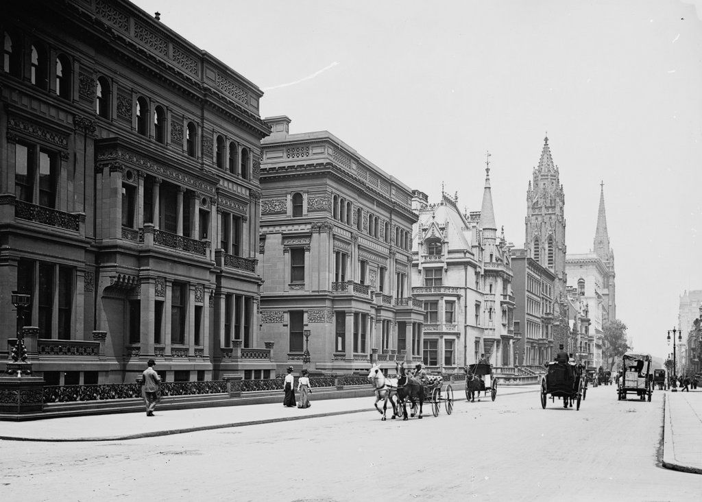
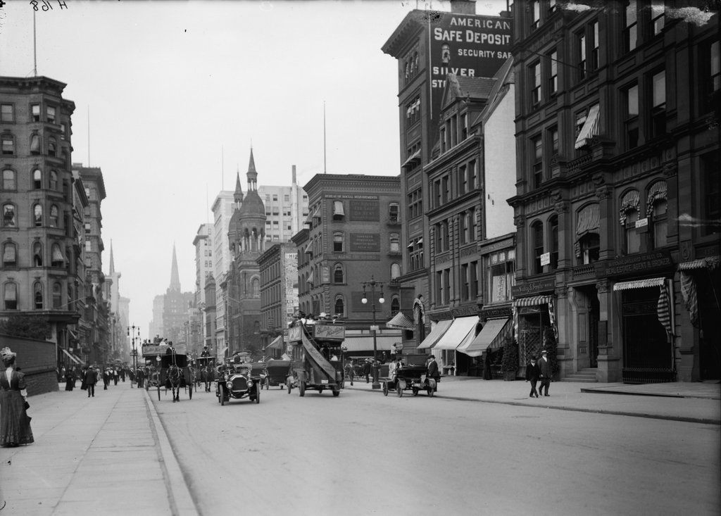
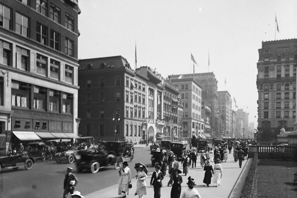
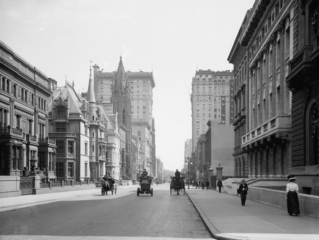
Fifth Avenue from 33rd Street, New York City

Looking north on Fifth Avenue from 33rd Street, around 1905-1920. Image courtesy of the Library of Congress, Detroit Publishing Company Collection.

917_1905-1920 loc

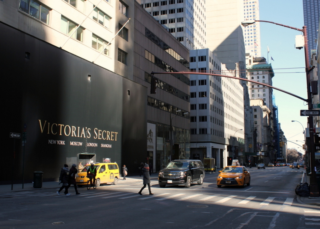
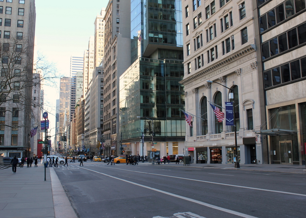
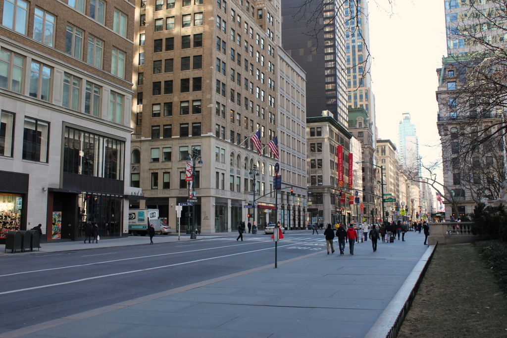
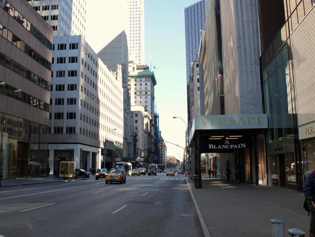
Fifth Avenue in 2016:

917_2016
Notice the extremely wide sidewalks in the first photo. Fifth Avenue was originally designed to have a 40-foot roadway with 30-foot sidewalks on either side, but this changed in 1908, shortly after the first photo was taken. To accommodate the growing automobile traffic on the street, it was widened to 55 feet, and the wide sidewalks were trimmed down. Despite over a century of change, though, there are a remarkable number of buildings that have survived from the first photo, especially on the left side. When the first photo was taken, this section of Fifth Avenue had just recently become a major commercial area, and as a result most of the buildings were new at the time.

Perhaps most surprising from the first photo is that the Knickerbocker Trust Company Building – the short building with columns in the center of the photo – is technically still standing, although it has long since been altered way beyond recognition. It was built in 1904 at the corner of Fifth Avenue and 34th Street as the headquarters of one of the nation’s largest banks, but soon after the bank inadvertently played a major role in causing the Panic of 1907. This banking crisis occurred around the time that the first photo was taken, after the Knickerbocker president, Charles T. Barney, attempted to corner the market in copper using the bank’s money. The plan failed, and in the days before FDIC-insured deposits, account holders rushed to the bank to withdraw their money as other banks announced that they would no longer accept checks from Knickerbocker accounts. Ultimately, the bank survived, although Barney was forced to resign and he committed suicide soon after. As for the building, it was significantly changed in 1921 with the addition of ten stories on top of it, and in 1958 the facade was altered to its current appearance, removing any exterior elements from the original structure.

Despite the number of surviving buildings from the first photo, there are several notable ones that have since been demolished. In the distance, at the corner of 37th Street, is the steeple of Brick Presbyterian Church, which was built in 1858 when this area was still largely residential, and it stood there until 1937. Probably the most famous building from the first photo, though, is the Waldorf-Astoria Hotel, on the left side in between 33rd and 34th Streets. This massive hotel is only partially visible in this view, and it stood here until 1929, when it was demolished to build the Empire State Building, which now stands on the site.

Astor Hall, New York Public Library, New York City

Astor Hall, at the entrance to the main branch of the New York Public Library, around 1911-1920. Image courtesy of the Library of Congress, Detroit Publishing Company Collection.

916_1910-1920 loc

The scene in 2016:

916_2016
Like the photo McGraw Rotunda in the previous post, this early photo of Astor Hall was probably taken around the time that the main branch of the New York Public Library opened in 1911. This marble entryway is named for the prominent Astor family. Upon his death in 1848, John Jacob Astor, the family patriarch, left funds to establish the Astor Library, a free public library that was later merged to form the New York Public Library system in 1895. The present-day main branch was built several years later, and not much has changed in this scene in the century since the first photo was taken, but the marble walls now bear the names of various benefactors of the library, including, appropriately, several generations of the Astor family at the top of the list.

McGraw Rotunda, New York Public Library, New York City

The McGraw Rotunda on the third floor of the New York Public Library Main Branch, around 1911-1920. Image courtesy of the Library of Congress, Detroit Publishing Company Collection.

915_1911-1920 loc

The scene in 2016:New York Public LibraryN

915_2016
The main branch of the New York Public Library, located at the corner of Fifth Avenue and 42nd Street, was completed in 1911, and the first photo was probably taken soon after, as it is part of a series of photos that the Detroit Publishing Company took to show the interior of the new building. The rotunda includes walnut paneling and a valuted ceiling, and the present-day photo also shows the murals that were added after the first photo was taken. Located on the walls and on the ceiling, the murals are entitled “The Story of the Recorded Word,” and were painted in 1937 by Edward Laning. One of them depicts Johannes Gutenberg holding a page from his famous Bible, which was the first book to have been printed using movable type. Appropriately, the McGraw Rotunda is also home to the New York Public Library’s copy of the Gutenberg Bible, which can be seen in the center of the 2016 photo. It was the first Gutenberg Bible in the United States, when James Lenox brought it here in 1847, and today it is one of only 49 existing copies in the world.

Lost New England Goes West: Venice, California

Looking east on Windward Avenue in Venice, around 1912. Image courtesy of the Library of Congress, Detroit Publishing Company Collection.

912_1900-1915 loc

The scene in 2015:

912_2015
Venice was founded in 1905 as a beach resort town just west of Los Angeles. Its developer, tobacco company owner Abbott Kinney, envisioned it as the “Venice of America,” complete with canals, gondolas, and Venetian-style architecture. Among the architectural features in the first photo are the arcades, or arches, along all of the buildings here on Windward Avenue. The building on the left at the corner is the Hotel St. Mark, which was built in 1905, and beyond it are a number of other matching buildings. On the right side, many of the buildings are not yet completed, with a row of columns marking where arches would eventually be built.

When the first photo was taken, Venice had already become a popular tourist destination. The white sign in front of the hotel advertises some of the city’s attractions, including the aquarium on the pier (admission 10 cents), the scenic railway, gondolas and boats on the canals, and the Venice Plunge, which was a heated indoor salt-water pool on one of the piers.

The city was successful in attracting tourists, but politically it was unable to support itself, so in 1926 the residents voted to be annexed by Los Angeles. This brought some major changes, which included filling in most of the canals and building roads on top of them. Venice’s decline continued during and after the Great Depression, and by the 1950s it was in serious decay. The piers were demolished by the 1960s, as were many of the historic buildings here along Windward Avenue and elsewhere in Venice.

Today, Venice is known for its unique countercultural aspects, including artists, street performers, and an inordinate number of medicinal marijuana dispensaries. A number of small shops now occupy the space where the Hotel St. Mark once stood, but a few of the buildings from the first photo still remain, including the one in the center of the photo and another further down Windward Avenue. Over the years, Venice has been used as a filming location for many movies and television shows, several of which feature this particular view here. The opening scene of Orson Welles’s 1958 film Touch of Evil shows the St. Mark a few years before its demolition, and a 2003 episode of Gilmore Girls includes several scenes from this section of Windward Avenue.

This post is part of a series of photos that I took in California this past winter. Click here to see the other posts in the “Lost New England Goes West” series.

Lost New England Goes West: Pismo Beach, California

The view looking north along the shore at Pismo Beach, California, around 1906. Image courtesy of the Library of Congress, Panoramic Photographs Collection.

910_1906c loc

Pismo Beach in 2015:

910_2015

I couldn’t perfectly recreate the first photo, since it was taken a thousand feet or so in the air, but the second photo shows roughly the same view from the ground. The 1906 photo was taken by George R. Lawrence, an early pioneer of aerial photography. He developed what he called a “captive airship,” which was a kite-supported camera that could take pictures up to 2,000 feet in the air, all while being controlled remotely from the ground. In many ways, Lawrence’s invention was an early version of a drone, and like modern-day drones, it was seen as a potential surveillance tool for the military. However, it was also commercially valuable, as demonstrated by Lawrence’s most famous photo, which was taken in the aftermath of the 1906 San Francisco earthquake. He sold prints of this image for $125 each (over $3,000 today), earning around $15,000 from it, or close to $400,000 in 2016.

While he was in California, though, San Francisco wasn’t his only job. Hoping to promote tourism to their new resort, the El Pizmo Beach Company hired Lawrence to photograph Pismo Beach, especially their El Pizmo Inn in the lower right of the photo. The inn included the “Tent City,” which consisted of several block of tents that measured 14 feet by 18 feet and could be rented for $6 per week. Entertainment at the resort included the dance pavilion, which is the building in the lower center of the photo with the cylindrical-shaped roof.

In the 109 years between the two photographs, not much is left from the original image. The hills in the distance have not changed much,but Pismo Beach itself has become the resort city that the 1906 owners of the El Pismo Beach Company probably hoped it would be. In the years after the aerial photo was taken, the tent city continued to grow, attracting many visitors from San Francisco who sought warmer temperatures in the southern part of the state. By the early 1930s, most of the tents were replaced with more permanent cottages, and the dance pavilion burned down in 1945. There are few landmarks left to identify the original image, although, as a point of reference, the pier in the distance on the left side of the 2015 photo is at about the same spot where the dance pavilion once stood.

This post is part of a series of photos that I took in California this past winter. Click here to see the other posts in the “Lost New England Goes West” series.

Lost New England Goes West: Old Saint Mary’s Cathedral, San Francisco

Old Saint Mary’s Cathedral at the corner of California Street and Grant Avenue in San Francisco, around 1856. Image courtesy of the DeGolyer Library, Southern Methodist University.

897_1856c smu

The church around 1866. Image courtesy of the Library of Congress, Lawrence & Houseworth Collection.

897_1866c loc

The church in 2015:

897_2015
As mentioned in earlier posts, San Francisco of the 1850s was very different from just a decade earlier. When gold was discovered in California in 1848, its population was just a thousand, but by the early 1850s it had jumped to over 30,000, and was rapidly growing. To accommodate the number of Catholics, the city’s first cathedral was built here in 1854, and the building has stood here ever since. At the time, it was located near the fringes of the city, near Chinatown and some of the notorious red light districts, which explains the “Son, Observe the Time and Fly from Evil” inscription just below the clock.

The first photo was taken before the steeple was completed, but by the early 1860s the church looked essentially the same as it does today. It served as the cathedral for the Archdiocese of San Francisco until 1891, and since then it has been a parish church. In 1906, it was one of the few buildings in the area to survive the earthquake, which did no serious structural damage to it. However, the earthquake started fires that gutted the building, so today the only original part of the church is the brick exterior.

The surrounding Chinatown neighborhood was rebuilt after the fires, and today it is home to the largest Chinese population in the world outside of Asia. This section of Grant Avenue in particular is a major tourist attraction, and Old Saint Mary’s Cathedral remains both an active church and also a major landmark that dates back to the city’s early years as a Gold Rush town.

This post is part of a series of photos that I took in California this past winter. Click here to see the other posts in the “Lost New England Goes West” series.