Lost New England Goes West: Santa Monica, California (1)

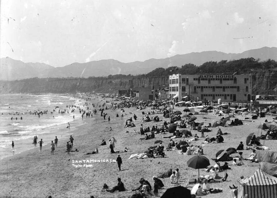
Looking north from the Santa Monica Pier in Santa Monica, California, around 1905. Image courtesy of the University of Southern California Libraries and the California Historical Society.
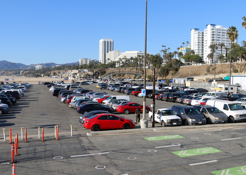
913_1905c usc

The view in 2015:

913_2015
These views shows Santa Monica looking north from the pier along the Palisades, the steep cliffs separating the city from the beach below. When the first photo was taken over a century ago, Santa Monica had already become a popular beach resort.. At the time, the area above the Palisades was still sparsely developed, but there were number of amenities along the beach, including a bath house that offered visitors the option of swimming in a heated indoor pool rather than the relatively cool ocean. The beach was crowded on this particular day in 1905, with the attire of the visitors reflecting the styles of the time, including men in dark suits and straw hats, women in long white dresses, and swimmers dressed in nearly full-body bathing suits.

Today, not much is left from the original photo except for the Palisades. Even the beach itself has been extensively altered and widened, and a large parking lot now sits on this spot. In the distance, hidden from view, the Pacific Coast Highway now runs along the bottom of the Palisades, beneath the modern hotels and condominium buildings that now line Ocean Avenue on the top of the cliffs.

This post is part of a series of photos that I took in California this past winter. Click here to see the other posts in the “Lost New England Goes West” series.

Lost New England Goes West: Pismo Beach, California

The view looking north along the shore at Pismo Beach, California, around 1906. Image courtesy of the Library of Congress, Panoramic Photographs Collection.

910_1906c loc

Pismo Beach in 2015:

910_2015

I couldn’t perfectly recreate the first photo, since it was taken a thousand feet or so in the air, but the second photo shows roughly the same view from the ground. The 1906 photo was taken by George R. Lawrence, an early pioneer of aerial photography. He developed what he called a “captive airship,” which was a kite-supported camera that could take pictures up to 2,000 feet in the air, all while being controlled remotely from the ground. In many ways, Lawrence’s invention was an early version of a drone, and like modern-day drones, it was seen as a potential surveillance tool for the military. However, it was also commercially valuable, as demonstrated by Lawrence’s most famous photo, which was taken in the aftermath of the 1906 San Francisco earthquake. He sold prints of this image for $125 each (over $3,000 today), earning around $15,000 from it, or close to $400,000 in 2016.

While he was in California, though, San Francisco wasn’t his only job. Hoping to promote tourism to their new resort, the El Pizmo Beach Company hired Lawrence to photograph Pismo Beach, especially their El Pizmo Inn in the lower right of the photo. The inn included the “Tent City,” which consisted of several block of tents that measured 14 feet by 18 feet and could be rented for $6 per week. Entertainment at the resort included the dance pavilion, which is the building in the lower center of the photo with the cylindrical-shaped roof.

In the 109 years between the two photographs, not much is left from the original image. The hills in the distance have not changed much,but Pismo Beach itself has become the resort city that the 1906 owners of the El Pismo Beach Company probably hoped it would be. In the years after the aerial photo was taken, the tent city continued to grow, attracting many visitors from San Francisco who sought warmer temperatures in the southern part of the state. By the early 1930s, most of the tents were replaced with more permanent cottages, and the dance pavilion burned down in 1945. There are few landmarks left to identify the original image, although, as a point of reference, the pier in the distance on the left side of the 2015 photo is at about the same spot where the dance pavilion once stood.

This post is part of a series of photos that I took in California this past winter. Click here to see the other posts in the “Lost New England Goes West” series.

Lost New England Goes West: Alcatraz Island, San Francisco (2)

Another view of Alcatraz Island, taken around 1900. Image courtesy of the National Park Service.

903_1900c nps

The view in 2015:

The first photo here was taken around the same time as the one in the previous post, showing Alcatraz Island when it was being used as a military prison. At the time, the island’s inmate population was rapidly growing, and within a few years many of the Civil War-era buildings in this scene would be demolished to build modern facilities. Building 64, the large building along the water in the present-day scene, was built in 1905 to house the officers who were stationed here. In 1909, the current lighthouse was built to replace the original 1854 structure, which had been damaged in the 1906 earthquake. Around the same time, the old Alcatraz Citadel, barely visible at the top of the hill, was demolished to build the main prison building. Completed in 1912, it was later converted from a military prison into a federal civilian prison, and still stands at the top of the island today.

The only building left from the first photo is the Guardhouse on the far right. Built around 1857, it is the oldest remaining structure on the island, dating back to the time when the island was used as a defensive fortification to protect San Francisco Bay. It was also used as the island’s first prison building in the 19th century, before the island’s role as a prison was expanded and purpose-built prison structures were added. Today, more than 50 years after the last prisoner left Alcatraz, the Guardhouse and the rest of the historic buildings on the  island are administered by the National Park Service, and the island is open to the public as part of the Golden Gate National Recreation Area.

This post is part of a series of photos that I took in California this past winter. Click here to see the other posts in the “Lost New England Goes West” series.

Lost New England Goes West: Alcatraz Island, San Francisco

Alcatraz Island in San Francisco Bay, around 1902-1905. Image courtesy of the National Park Service.

902_1902-1905c nps

Alcatraz in 2015:

Alcatraz Island is located at a strategic point just inside the entrance to San Francisco Bay. The United States acquired California in 1848, and within ten years this small island had been fortified to protect the bay from any potential threats. Known as the Alcatraz Citadel, it was finished just in time for the Civil War, and although it never saw any combat during the war, its isolated location made it an ideal place to house Confederate prisoners.

After the war, the focus on Alcatraz shifted from defense to incarceration, and from 1868 to 1933 it functioned as a military prison. The first photo was taken during this era, showing a number of buildings on the island that were used to house either the inmates or the military personnel stationed there. At the top of the hill in the first photo is the Alcatraz Citadel, which was demolished a few years later to build the main prison building that stands there today. Most of the other buildings from the first photo have since been demolished, including those along the water, which were replaced by Building 64 in 1905. This large building, which was originally used to house military officers and their families, is still standing today just to the right of the center of the photo.

When the military prison closed in 1933, the property was transferred to the Department of Justice, and in 1934 it reopened as a civilian prison for the nation’s most difficult prisoners. Considered essentially escape-proof, there were never any confirmed successful escapes, although three inmates did disappear in the famous 1962 attempt. Alcatraz was expensive to maintain, though, and it closed in 1963. After the closure, the island was occupied by Native Americans for 19 months in 1969-1971, during which time several of the buildings were burned. Later, the island was acquired by the National Park Service, and is now open to the public as part of the Golden Gate National Recreation Area.

This post is part of a series of photos that I took in California this past winter. Click here to see the other posts in the “Lost New England Goes West” series.

Lost New England Goes West: Old Saint Mary’s Cathedral, San Francisco (3)

Another view of the Old Saint Mary’s Cathedral, taken looking down California Street, around 1900. Image courtesy of the Library of Congress, Historic American Buildings Survey Collection.

900_1900c loc

The view in 2015:

900_2015
The first photo shows California Street just a few years before nearly this entire scene was destroyed in the 1906 earthquake. The most prominent building in the first photo is the Old Saint Mary’s Cathedral, and this is also the only building that survives to the present day. As seen in the previous post, though, not much is left of the original building. It was completely gutted in the fires, and today only the exterior walls are left from the 1854 church. The city around the church has obviously changed; in the distance are the skyscrapers of the Financial District, and in the foreground is Grant Avenue, part of the city’s Chinatown neighborhood.

The only other feature that both photos have in common is the cable cars. One of San Francisco’s most recognizable symbols, the cable car line on California Street was established in 1878. Although more expensive to operate than conventional electric trolleys, cable cars remained in use for many years because of the city’s many hills, which are far too steep for a trolley. Rather than relying on overhead wires for power, cable cars are literally pulled up the hills on a continuously-moving 1.25 inch steel cable. To stop the car, the operators simply disengage from the cable and reconnect when they are ready to continue uphill. The technology has not changed much since the first photo, but the major difference is that today’s cable cars are primarily tourist attractions rather than as a significant part of the city’s public transit system.

This post is part of a series of photos that I took in California this past winter. Click here to see the other posts in the “Lost New England Goes West” series.

Lost New England Goes West: Old Saint Mary’s Cathedral, San Francisco (2)

Old Saint Mary’s Cathedral, at the corner of California Street and Grant Avenue, in the aftermath of the April 18, 1906 earthquake and fires. Image courtesy of the Library of Congress, Historic American Buildings Survey Collection.

899_1906c loc

The church in 2015:

899_2015
As mentioned in an earlier post, this church was built in 1854 as the first Catholic cathedral in San Francisco. The archdiocese moved to a new building in 1891, but Saint Mary’s remained a parish church. In 1906, though, the building burned in the earthquake that destroyed much of the city. The first photo shows the church after the fire, with interior was completely gutted. The stained glass windows were gone, and the heat of the fire even melted the bells and the marble altar.

However, the brick walls withstood both the earthquake itself and the fires, and the church reopened in 1909 with a new interior. Over a century later, it remains an active congregation, and it is a prominent landmark in the middle of San Francisco’s Chinatown neighborhood.

This post is part of a series of photos that I took in California this past winter. Click here to see the other posts in the “Lost New England Goes West” series.