Put’s Bridge, Springfield Mass

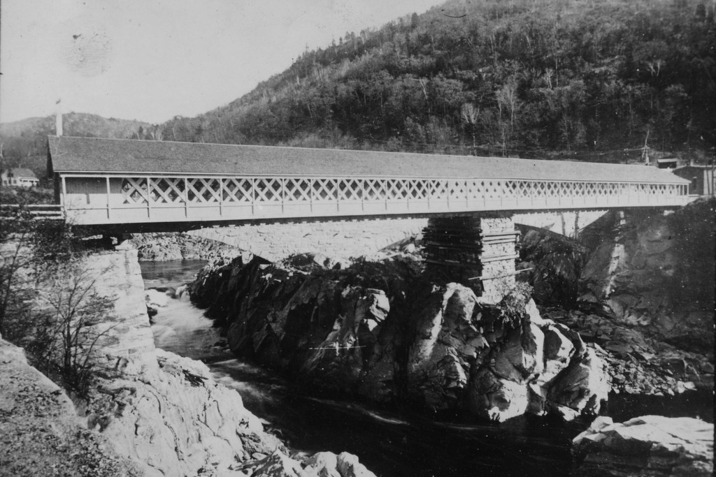
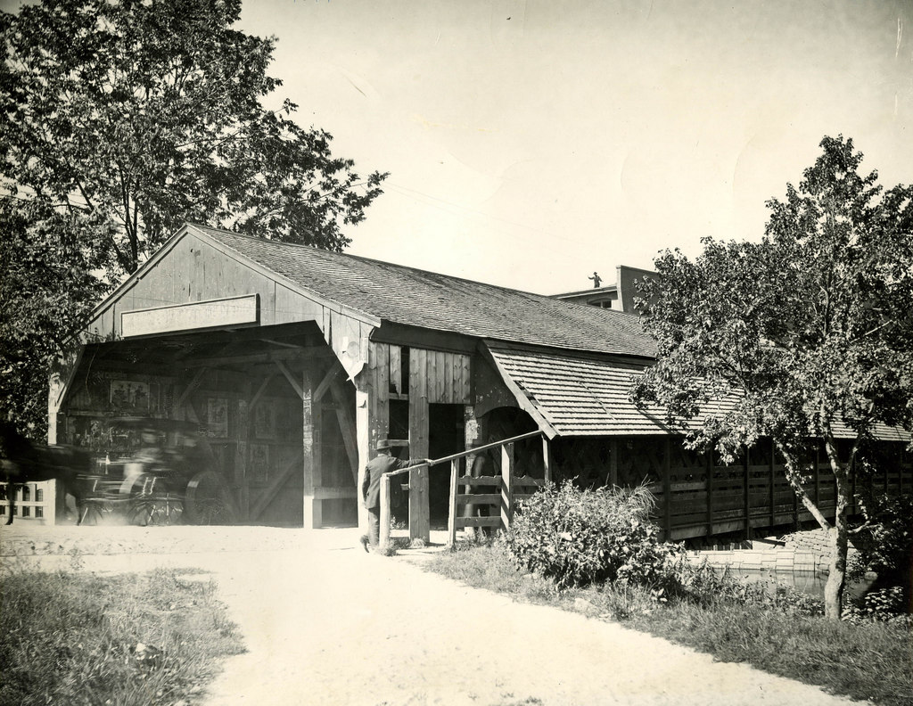
The old covered bridge across the Chicopee River from Springfield to Ludlow, taken from the Springfield side in 1897. Photo courtesy of the Hubbard Memorial Library.

473_1897 hubbardmemlib

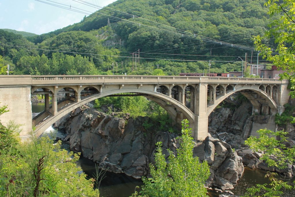
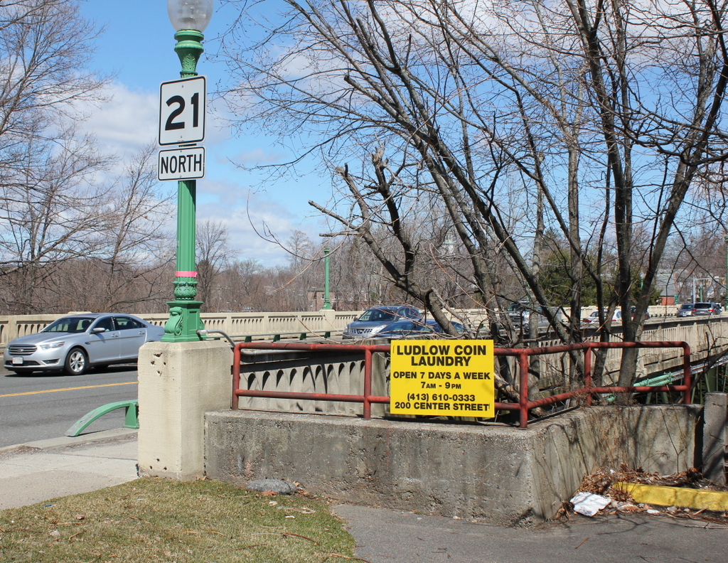
The present-day bridge in 2015:

473_2015

Alternately called Putts Bridge, this spot at Wallamanumps Falls on the Chicopee River has long been the site of a bridge connecting Springfield and Ludlow.  The early accounts are somewhat vague, but the first bridge was built in either the late 1780s or early 1790s.  Either way, a bridge was definitely here by 1794; prior to that, Ludlow’s 500 or so residents would have to get to and from Springfield by fording the river, a task that I can’t image was particularly pleasant or safe.  The bridge was constructed by Eli Putnam, hence the name Put’s bridge.  However, bridges here didn’t seem to have much of a lifespan; in the next 30 years, three additional bridges would have to be constructed on this site.

The 1822 bridge must have been different, because it lasted until this 1897 photograph.  By this point, though, the 75 year old bridge was starting to show its age, and the next year it was replaced with a new iron bridge.  However, the replacement didn’t even last half as long as its predecessor before it was replaced by the current bridge in 1930.  Today, this concrete and steel bridge carries Route 21 across the river, and it still serves as the primary connection from Ludlow to Springfield.  The one difference in the location of these two photos is that the covered bridge was at a substantially lower elevation, so the 1897 photo would’ve actually been taken partway down the hill toward the river.  I could’ve recreated the scene from here, but I chose this location since it represents what the surface of bridge today looks like, rather than just the underside of it.

Tucker Toll Bridge, Bellows Falls, Vermont (2)

Another view of the Tucker Toll Bridge, from the downstream side, probably around 1900 Image courtesy of the Rockingham Free Public Library.

The bridge in 2018:

This is another view of the bridge across the Connecticut River at Bellows Falls, seen from the Vermont side facing upstream.  As explained in this post, this was the site of the first bridge across the Connecticut River when a primitive bridge was built across here in 1785.  The bridge in the 1907 photo was the second on the site, and opened in 1840.  This bridge, known as the Tucker Toll Bridge, was replaced by the current concrete arch bridge, the Vilas Bridge, in 1930.  However, the bridge has been closed since 2009, and as of 2018 it is unknown what will happen to it.

This angle gives a good view of the gorge at Bellows Falls, where the Connecticut River drops 52 feet through a narrow gorge.  It was originally known as the Great Falls, and an early stagecoach line that ran through here advertised that passengers would be able to “view one of the most stupendous works of Nature.”  Today, much of the river’s water is diverted into a power canal just above the falls, so it isn’t as dramatic as it would have been to an 18th century traveler, but it is still an impressive view looking down from the top of the gorge.

Tucker Toll Bridge, Bellows Falls, Vermont (1)

The Tucker Toll Bridge over the Connecticut River at Bellows Falls, Vermont, around 1900-1910. Image courtesy of the Library of Congress, Detroit Publishing Company Collection.

Vermont

The scene in 2014:

418_2014

As mentioned in this post, Bellows Falls became a major transportation and industrial center in the region during the 19th century because of its location on the Connecticut River.  As seen in these photos, the river drops 52 feet in elevation through a narrow gorge, making it an ideal site for hydroelectrically-powered industries, but also a strategic location to build a bridge.  Further south, the river was much wider and bridge-building viewed as almost impossible; one man reportedly commented on the idea in Springfield, Mass. around 1800, saying, “Gentlemen, you might as well undertake to bridge the Atlantic Ocean.”

However, here in Bellows Falls the width of the river and the rocky outcroppings meant a shorter bridge and no need to build piers in the river.  As a result, the first bridge across any part of the Connecticut River opened on this spot in 1785, connecting New Hampshire and Vermont and facilitating trade from New Hampshire to Montreal and other northern destinations.  At the time, Vermont was actually an independent nation, which I suppose technically made the first bridge an international border crossing.

The construction of the bridge was authorized by the state of New Hampshire, who also set the tolls for travelers; in 1804, the tolls ranged from three cents for a person on foot, to 30 cents for a four wheel carriage with four horses.  Upon completion, the Massachusetts Spy gave a glowing review of the bridge, writing:

“We hear from Walpole, state of New Hampshire, that Colonel Enoch Hale hath erected a bridge across the Connecticut River on the Great Falls, at his own expense.  This bridge is thought to exceed any ever built in America in strength, elegance, and public utility, as it is the direct way from Boston through New Hampshire and Vermont to Canada, and will exceedingly accommodate the public travel to almost any part of the state of Vermont.”

The 1907 book History of the Town of Rockingham Vermont provides this depiction of the bridge, viewed from about the same spot as the two photographs:

Picture1

This first bridge was uncovered, which meant the wood deck and structure was exposed to the elements, so by 1840 it was in need of replacement.  The new bridge, which is the same one in the first photo here, was built directly over the old one, about 15 feet above it, which allowed the old bridge to continue to be used even as its replacement was being built.  The 1840 bridge became known as the Tucker Toll Bridge, named after the family who owned it for many years.  It remained in the hands of private owners until 1904, when the towns of Rockingham and Walpole purchased it and made it free for travel.  This bridge was, in turn, replaced by the current concrete arch bridge in 1930.  However, it has deteriorated over the years, and was closed in 2009 because of safety concerns.  At this point, it remains to be seen what will happen to the bridge.