Aftermath of 1869 Flood, Brattleboro, Vermont

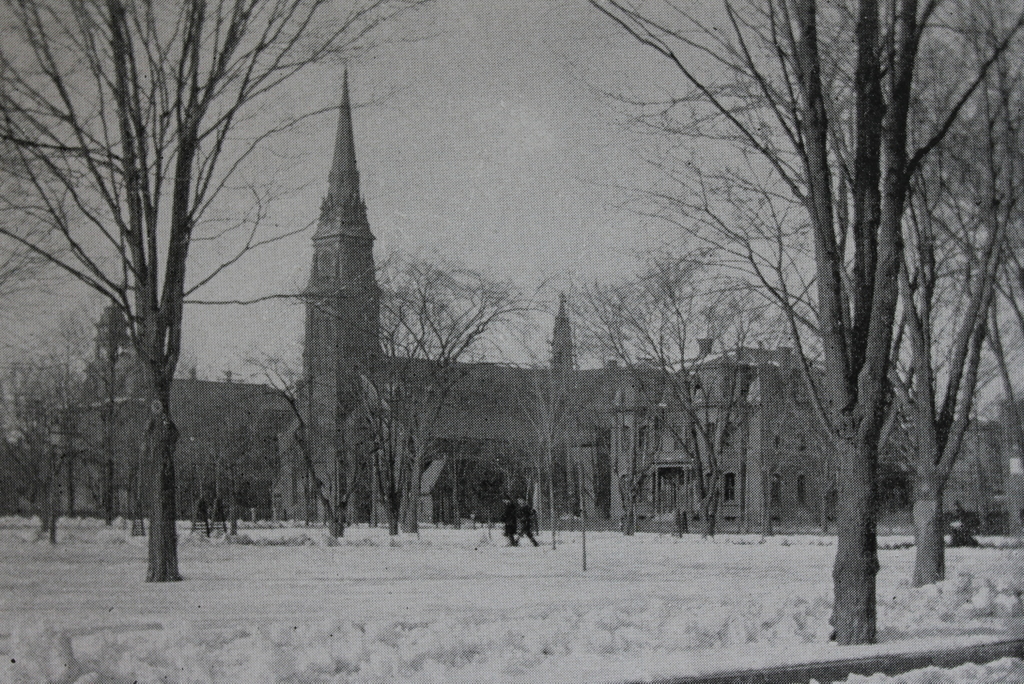
The scene looking north on Main Street from the Whetstone Brook in Brattleboro, apparently in the aftermath of the October 4, 1869 flood. Image courtesy of the New York Public Library.
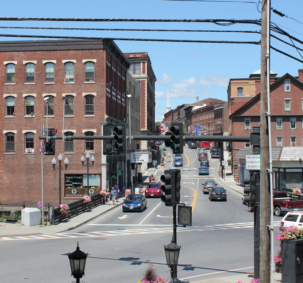
The scene in 2017:

The first photo is undated with no caption, but it almost certainly shows the aftermath of the October 4, 1869 flood, which was among the most disastrous floods in the history of Brattleboro. The town has always been vulnerable to flooding, given its location on the banks of the Connecticut River, but the majority of the damage in this particular flood was caused by the small but fast-moving Whetstone Brook, which passes through downtown Brattleboro in the foreground of this scene. Originating in the hills to the west of here, the Whetstone provided the water power for many of Brattleboro’s early industries. However, this proximity to the brook also made these factories vulnerable to flooding, which could come with little warning.

Although rapid changes in the water level were not uncommon, the October 1869 floodwaters were higher than any in recorded history up to that point, and came after 36 hours of heavy rainfall. The flooding began shortly after 11:00 on the morning of October 4, and initially the primary concern was removing goods from the basements of homes and businesses on Flat Street, which runs along the north side of the brook. However, within ten minutes the water level had risen to the point where the focus shifted from saving property to saving lives. The book Annals of Brattleboro, 1681-1895 provides a detailed description of the subsequent events:

John L. Ray’s livery stable floor was completely covered with water. Many ready and willing hands were there to seize his horses by the bridle and lead them to a place of safety; all his buggies and horses were taken to high ground on Main Street. So suddenly did the waters spring upon the workmen in the blacksmith shop of Mr. Hall, that the floor was afloat and the workmen were obliged to break through a back door and climb up a stone wall and take shelter upon Elliot Street. A frame workshop just beyond the smithy was washed from its foundation and swung completely around. Mr. Dunklee, occupying the first house on the right-hand side of Flat Street, had just begun to gather up his things on the first floor of his tenement when he was obliged to call for help for the rescue of himself, wife and two other females. Help was promptly given him by Mr. John Rogers of the Revere House, who did yeoman’s service and saved them, although they were all pretty well drenched. In the next house resided Mr. Frank Holding, whose wife had been for four weeks dangerously ill with typhoid fever; their lower floor was completely inundated. Ropes and boats were procured by the spectators, who numbered hundreds, and after much peril and great exertion, the family were taken alive. The house of Willard Frost, on the lower side of the street, was in a peculiarly exposed situation. Fences were broken down by the ferocity of the current, the woodshed was veered around, the barn was shaken on its foundation, and inevitable destruction seemed imminent. The house was occupied by the female members of Mr. Frost’s family together with Mr. Eugene Frost, Mr. Wells Frost and his mother. They all went to the upper chamber of the house and there made signals of distress from the windows to the assembled multitude on Elliot Street. The rapid current which eddied and whirled around the house on all sides made it next to impossible for a boat to live in the waters. Several attempts were made to reach the house, but without success and these people suffered agonies untold for many minutes, until at last the timbers which had floated between the buildings formed a raft, on which they safely passed to the shore.

The large dam at B. M. Buddington’s gristmill was washed away, and the tannery which stood below was demolished and two thousand hides taken down the stream. Spenser & Douglas’s shop was entirely swept away and the road all along ruined. The bridge near the old woolen factory went down, on which two ladies had stood a moment before, barely escaping with their lives. The swollen stream then swept over Frost meadow reaching Estey & Company’s organ factory, doing no damage to the buildings, but carrying off thousands of feet of lumber and tearing up the road badly. On the south side of the brook, Woodcock & Vinton’s canal for about two hundred rods was torn out and one of the buildings and some paper injured. The flood swept away in a moment, Dwinell’s furniture shop with all its contents, furniture, tools, stock and account books, the Main Street bridge, A. F. Boynton’s shoe shop, office of I. K. Allen, lumber dealer, and Boyd’s fish market. Several men were in the market, among them the proprietor – he felt the building tremble and singing out “Run for your lives,” quickly he followed his flying guests. He sprang out of the door, turned around to look and saw nothing but a mass of water where a second before had stood his place of business. On the other side the planing mill of Smith & Coffin was cleaned out of its machinery, tools, etc.; the machine shop of Ferdinand Tyler was struck by the timbers and a part of the underpinning knocked away, the sawmill near the bridge and the foundry below were swept into the Connecticut with all their contents.

Nearly all of the bridges across the Whetstone Brook were destroyed by the flood, including the one here on Main Street. The first photo shows a large ditch where the bridge had once been, with wreckage strewn across the scene. The flood caused an estimated $300,000 in damage, equivalent to about $5.6 million today, and also killed two people. One of the victims was Adolph Friedrich, a Prussian immigrant sho left behind a wife and five young children. Twelve years earlier, Friedrich had survived the sinking of the treasure ship S.S. Central America, which was lost in a hurricane off the coast of the Carolinas. He had been returning from the gold fields of California, but he lost his fortune in the shipwreck. He eventually made his way to Brattleboro, where he found work at the Estey Organ Company. Friedrich was working there when the flood hit, and was swept downstream on a raft of boards. He was last seen going over the waterfall near the Main Street bridge, and his skeletal remains were later discovered on a riverbank. The other victim of the flood was Kittie Barrett, a 16 year old girl who had been watching debris float by at the tannery. She was killed when the upstream dam broke, and her body was recovered about a quarter mile downstream.

Today, nearly 150 years after this disastrous flood, this scene has remained remarkably unchanged. Some of the old buildings, particularly on the left side of the street, were replaced in the late 19th or early 20th centuries, but overall the area retains a similar scale in both photos. The right side, though, has been well-preserved, and a number of the buildings from the first photo are still there. The most noticeable of these is the Van Doorn Block on the far right, with its large, pedimented gable. Built in 1850, the brick building survived the 1869 flood and still stands, with few noticeable changes over the years. Further up the street, other survivors from the first photo include the Devens, Exchange, and Cutler Blocks, which were built in the early 1840s and form a continuous facade from 85 to 97 Main Street. Even further in the distance, near the center of the scene, are several other mid-19th century buildings that are still standing. Today, all of these buildings form part of the Brattleboro Downtown Historic District, which was added to the National Register of Historic Places in 1983.

Connecticut River, Brattleboro, Vermont

The view of Brattleboro, Vermont, seen looking northwest from the bridge over the Connecticut River, around 1894. Image from Picturesque Brattleboro (1894).

The scene in 2017:

These two photos were actually taken in Hinsdale, New Hampshire, since the state line runs along the western side of the Connecticut River. However, the subject of the photos is Brattleboro, a town that developed along the banks of the river during the 19th century. Located near the southeastern corner of Vermont, Brattleboro was among the earliest towns in the state, and was settled soon after the conclusion of the French and Indian War, when French invasions from Quebec were no longer a threat. Its location along the Connecticut River made Brattleboro an important center for both trade and manufacturing, and by the middle of the 19th century it was rapidly growing as a mill town.

Many of the buildings in downtown Brattleboro date back to this period, and some of these are visible in these two photos. The left side of the first photo shows the rear of the buildings on the east side of Main Street, most of which are still standing today, although hidden by trees in the 2017 photo. Further in the distance, on the far left of both photos, is the tower of the Brooks House, a large hotel that was built in 1871 at the corner of Main and High Streets. Two other landmarks in this scene include the steeple of the 1870 First Baptist Church in the center, and the steeple of the 1842 Centre Congregational Church on the right side.

Today, this scene has not significantly changed, more than 120 years after the first photo was taken. The Connecticut River appears somewhat higher in the present-day view, perhaps a consequence of the 1908 construction of the Vernon Dam, which is located a few miles downstream of here. Overall, though, Brattleboro has remained well-preserved over the years, with many historic commercial buildings still lining both sides of Main Street. Most of the buildings here in this scene are now part of the Brattleboro Downtown Historic District, which was added to the National Register of Historic Places in 1983.

Wells Fountain, Brattleboro, Vermont

The Wells Fountain, at the corner of Putney Road and Linden Street in Brattleboro, around 1905. Image courtesy of the Library of Congress, Detroit Publishing Company Collection.

The scene in 2017:

The Wells Fountain has been a feature here in the center of Brattleboro since 1890, when it was given to the town by William Henry Wells, a New York businessman who had grown up in Brattleboro. The fountain was originally located about 20 feet from here, but it was moved to its current site in 1906. The first photo appears to have been taken shortly before this move, because the photo shows it closer to the street than it is now, so the original location was probably on the far left side of the present-day photo.

The fountain was the the work of William Rutherford Mead, a noted architect who, like Wells, was a Brattleboro native who moved to New York as an adult. Mead was a cousin of President Rutherford B. Hayes, whose family also had roots in Brattleboro, and he was a partner in the prominent architectural firm of McKim, Mead & White. Mead did not have the same architectural genius of his two partners, Charles Follen McKim and Stanford White, and he designed few works on his own. Instead, his talents were as an office manager, serving as a stable, practical-minded counterbalance to the more fanciful McKim and White. Under his leadership, the firm became one of the country’s leading architects of the late 19th and early 20th century, with commissions such as the Boston Public Library, the Rhode Island State House, and Penn Station, along with many other public buildings and Gilded Age mansions.

The original location of the fountain marked the spot where Mead’s older brother, Larkin Mead, had created an eight-foot-high snow sculpture in 1856. The Recording Angel, as it was called, stood here for about two weeks, and the subsequent publicity helped to launch his career as prominent sculptor. He would later go on to design works such as the statue atop the Vermont State House, a statue of Ethan Allen in the United States Capitol, and the statues on Abraham Lincoln’s tomb. He died in Florence, Italy in 1910, and his grave was topped with a replica of his original Recording Angel sculpture.

Today, the Wells Fountain still stands here at the corner of Linden Street and Putney Road, although its surroundings have changed significantly. The trolley tracks in the foreground of the first photo are long gone, as are many of the surrounding buildings. The land just up the hill behind the fountain was once privately owned, with a house that once stood just out of view to the right. However, this land is now a small public park in front of the courthouse, and part of the foundation of the old house can still be seen on the far right side of the present-day photo.

William B. Howard Memorial Fountain, Wales, Mass

The fountain at the corner of Main Street and Haynes Hill Road in Wales, around 1892. Image from Picturesque Hampden (1892).

The scene in 2025:

This fountain has been located here on Main Street in Wales since 1887, when it was donated to the town by William B. Howard. Born in Wales in 1832, Howard later moved west to Chicago, where he became a successful contractor. He was responsible for the construction of a number of railroads and bridges, but he was also involved in several other major projects, including the construction of the Indiana State House and the New Croton Aqueduct. Howard often returned to Wales as a summer visitor, where he stayed at the home of Myles Needham, and in 1887 he gave this fountain to the town as a gift. It was made of granite quarried from nearby Monson, and the design of the fountain is essentially identical to one in Monson, which now stands in front of Memorial Hall.

The top photo shows the fountain as it appeared shortly after it was installed at this site. Just beyond it to the left is a house that once served as the parsonage for the Wales Methodist Church. According to the state’s MACRIS database of historic buildings, the house may have been built around 1850, and at the time it was owned by a William Thompson. However, in 1858 the house was sold to the church, which used it as its parsonage until around the turn of the 20th century. The house subsequently reverted to a private residence, but it is still standing today, as is the fountain in the foreground.

Park Street from Adams Street, Holyoke, Mass

Looking north on Park Street from the corner of Adams Street in Holyoke, around 1892. Image from Picturesque Hampden (1892).

The scene in 2017:

This view shows the scene from Adams Street, looking north toward the triangular park between Park Street (now Clemente Street) on the left and South East Street on the right. Here, the street grid of the South Holyoke neighborhood, which runs parallel to the Third Level Canal, meets the street grid of the rest of the city. This formed a small wedge of land in the center of the photo, just south of Sargeant Street, as well as a larger one just beyond it, in the block between Sargeant and Hamilton Streets. Originally known as Hamilton Park, and later the Hamilton Street Park, this was the largest open space in the neighborhood, and the first photo shows a mix of wood-frame and brick buildings on either side of the street. Further in the distance, in the center of the photo, is the Hamilton Street School, located on part of the triangle between Hamilton, Park, and South East Streets.

When the first photo was taken, this neighborhood was predominantly French-Canadian, although there was also a considerable German population as well. The 1900 census, which was done only a few years after the first photo was taken, gives some interesting insight into this neighborhood. For example, the house on the right was owned by August Ruppert, a 46-year-old German immigrant who ran a grocery store in the first floor of the building. He had immigrated to the United States in 1882, followed a year later by his wife Mary and their two young children, Richard and Annie. They had a third child, Emma, several years years later, and by 1900 they were living here in this house, with Richard working as a plumber and Annie as a weaver in a woolen mill. The census also shows On Wo living right next door at 282 Park Street. A Chinese immigrant, he was about 38 years old, and he worked as a laundryman, probably in the second storefront on the right side of the photo.

Today, nothing is left from the first photo except for the park and the streets themselves. Even then, they have undergone changes, with the Hamilton Street Park becoming Carlos Vega Park in 2012, and Park Street becoming Clemente Street. A 1911 city atlas shows over 40 buildings in this two-block section of Park and South East Streets, but today there are only five, with overgrown vacant lots comprising most of the streetscape. The present-day photo shows the effect that the loss of manufacturing jobs has had on Holyoke, and similar scenes can be found in other once-thriving neighborhoods in the city.

St. Jerome’s Church, Holyoke, Mass

St. Jerome’s Church and Rectory on Hampden Street in Holyoke, around 1892. Image from Picturesque Hampden (1892).

The scene in 2017:

During the mid-19th century, Holyoke was developed into a major industrial center. Many factories were built along the city’s network of canals, and were powered by water from the Connecticut River, which drops 58 feet at the falls between Holyoke and South Hadley. The factories led to a dramatic population growth, particularly with immigrant groups such as the Irish and the French Canadians, who came to Holyoke in search of work, and this led to an abundance of Catholic churches to serve these two predominantly Roman Catholic communities.

The first of these Catholic churches was St. Jerome’s Church, which was established in 1856. The church building, seen here in the center of both photos, was constructed two years later, diagonally opposite Hampden Park at the corner of Hampden and Chestnut Streets. It features a brick, Gothic Revival-style design and, like many other Catholic churches of the era, was designed by prominent Irish-born architect Patrick Keely.

As the Catholic population of Holyoke continued to grow, a number of additional buildings were added around St. Jerome’s Church. The St. Jerome Institute was established as a school for boys in 1872, and was located in a building just to the left of the church, on the far left side of the first photo. Then, in 1879, a Second Empire-style church rectory was built to the right of the church, on the opposite side of Chestnut Street, and is visible on the right side of both photos. Other buildings constructed during this time included the Sisters of Notre Dame Convent (1870), the Convent of the Sisters of Providence  (1886), and the School of the Immaculate Conception (1883), all of which were located across Hampden Street opposite the church, just out of view to the left.

St. Jerome’s Church was significantly damaged by a fire in 1934 that left only the exterior brick walls still standing. However, the building was reconstructed a year later, and it remains in use today as an active Roman Catholic parish. Most of the other 19th century buildings nearby are still standing, aside from the St. Jerome Institute, which was demolished in the late 20th century. Today, these remaining buildings, including St. Jerome’s Church, now form part of the Hampden Park Historic District, which was added to the National Register of Historic Places in 2012.