Copp’s Hill Burying Ground, Boston

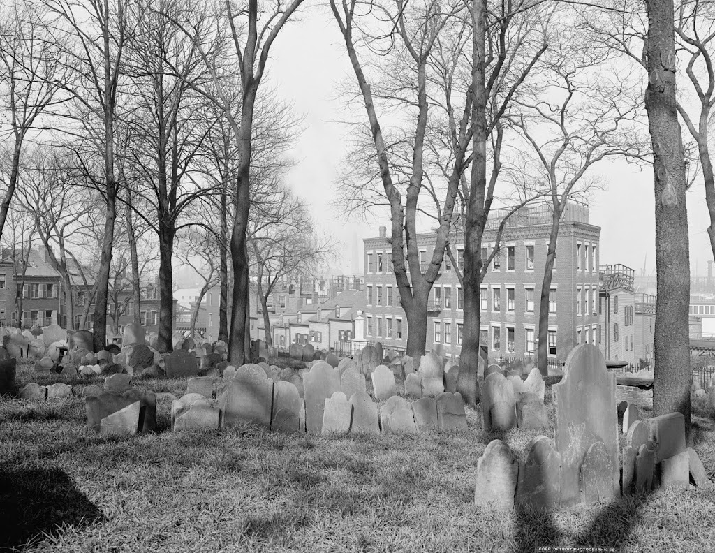
Copps Hill Burying Ground, around 1904. Image courtesy of the Library of Congress, Detroit Publishing Company Collection.

Cemeteries

The cemetery in 2014:

267_2014

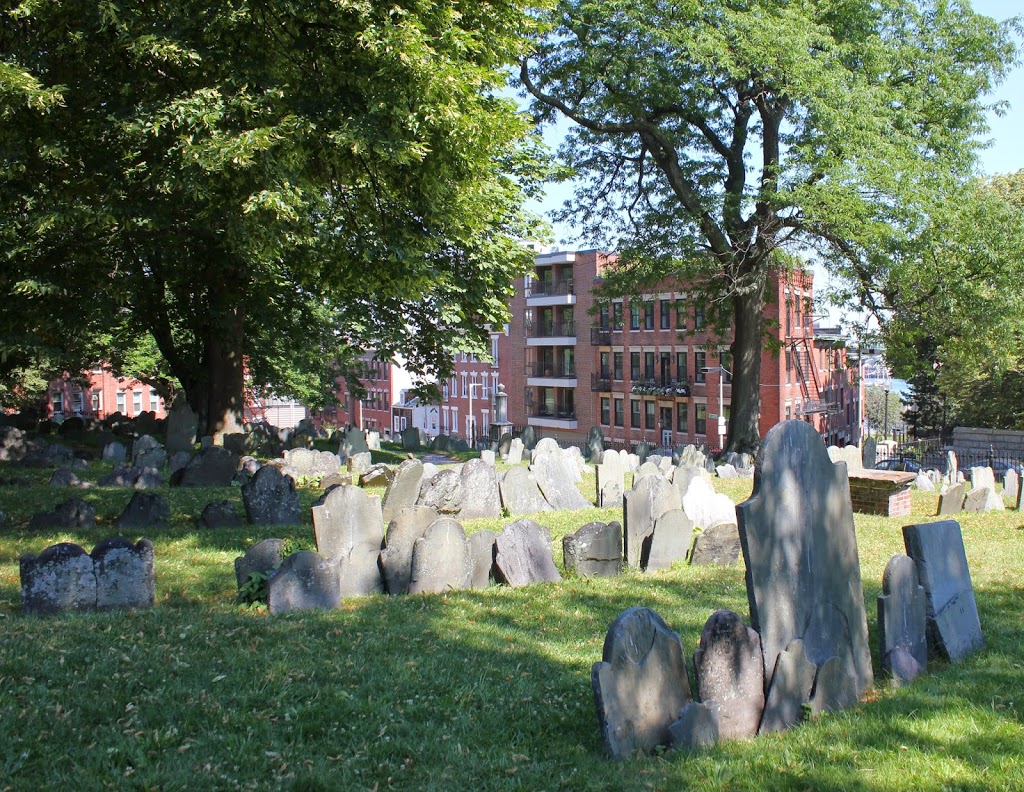
It’s almost a little eerie to see how little the cemetery has changed in the past 110 years.  Many of the headstones are even still tilted the same way as they were in 1904, and a few of the trees are still there; the tall, skinny tree in the 1904 photo just to the left of the corner of the building in right-center appears to be the same one that is there today.

The cemetery is located just up the hill from Old North Church, and is a stop on the Freedom Trail in Boston’s North End.  Although it doesn’t have as many famous interments as the Granary Burying Ground, there are still some notable people buried here, including Puritan ministers Increase and Cotton Mather, and Edmund Hartt, a shipbuilder whose most famous work, the USS Constitution, still sits right across the harbor from here.

Boston Molasses Disaster (4)

The remains of the molasses storage tank following the Boston Molasses Disaster in 1919. Image courtesy of the Boston Public Library.

237_1919-bpl

The same view in 2014:

237_2014

The storage tank that was responsible for the January 15, 1919 Boston Molasses Disaster had been hastily constructed in 1915.  At the time, World War I was ongoing in Europe, and although the United States remained officially neutral, American companies were supplying munitions and other items to Europe.  One important product was industrial alcohol, and the increased demand led the Purity Distilling Company to quickly build a 50 foot tall and 90 foot diameter tank to store molasses, which would later be transported and distilled into alcohol.

The tank was known for its frequent leaks, but the company’s response was to paint it brown to camouflage the molasses that dripped down the side.  Often, residents would help themselves to some of the leaking sweetener, likely unaware of the danger that the tank posed.  However, on January 15, 1919, the tank burst, likely due to the internal pressure caused by the fermentation of the molasses, along with the rapid rise in air temperature from the previous day.

The resulting flood created a 25-foot wave that killed 21 people, injured around 150, and caused extensive property damage.  Today, the area has been redeveloped as a park, with the actual location of the tank being approximately where this baseball diamond is located today, at what is now known as Langone Park.  Notice the Charlestown waterfront in the distance, including the masts of the USS Constitution.

Boston Molasses Disaster (3)

The Engine 31 firehouse along Commercial Street in Boston’s North End, following the 1919 Boston Molasses Disaster.  Image courtesy of Boston Public Library.

236_1919-bpl

The scene in 2014:

236_2014

As mentioned in this post, the Engine 31 firehouse was located right next to the molasses storage tank, and was knocked off of its foundation by the 25-foot wave that resulted when the tank burst.  One firefighter, George Layhe, was trapped under the building and drowned in the molasses.  Today, the scene along the waterfront is a public park, with little evidence of its industrial past or the disaster that occurred here 95 years ago.

Boston Molasses Disaster (2)

Another view of the aftermath of the Boston Molasses Disaster of 1919. Image courtesy of Boston Public Library.

235_1919-bpl

The scene in 2014:

235_2014

Because of the properties of molasses, a flood of it is very different from a flood of water or similar liquid.  Many victims of the January 15, 1919 Boston Molasses Disaster drowned in the molasses, not necessarily because they didn’t know how to swim, but because swimming in molasses is impossible.  It also made rescue and recovery operations difficult; notice the firemen wading in knee-deep molasses, with everything around them coated in it.  In this particular scene, they are working next to a firehouse that once existed along the waterfront; it was completely swept off of its foundation by the 25-foot wave of molasses that came when the nearby storage tank burst.  One fireman at the station, George Layhe, was trapped under the building and drowned in the molasses; he was one of the 21 people killed in the accident.  Today, the site of the molasses tank and the firehouse has been turned into a public park, as seen in the 2014 photo.

Boston Molasses Disaster (1)

The view looking northwest on Commercial Street in Boston’s North End in 1919, in the aftermath of the Boston Molasses Disaster. Image courtesy of Boston Public Library.

234_1919-bpl

The same scene in 2014:

234_2014

It almost seems comical to think of a massive flood of molasses, but the Boston Molasses Disaster was actually a serious tragedy that killed 21 people and injuring about 150 others.  On January 15, 1919, a 50-foot tall tank of molasses burst along the waterfront in the North End, flooding the neighborhood with 2.3 million gallons of the thick, sticky substance.

The tank was located on the left-hand side of Commercial Street, just to the right of the photo, and along with killing or injuring a number of people, it also caused substantial property damage, sweeping buildings off their foundations as causing heavy damage to the Commercial Street elevated railway, as seen in the photo above.  Today, the elevated tracks are long gone, and most of what was once an industrial area on the right-hand side along the waterfront is now a public park.

Springfield & Connecticut River from Forest Park

The view looking toward Springfield from atop Laurel Hill in Forest Park, around 1905. Image courtesy of the Library of Congress, Detroit Publishing Company Collection.

224_1905c-loc.tif

The same view in 2014:

224_2014

While driving along Interstate 91 through the Longmeadow curve, there is a semicircular retaining wall built into the side of the hill, with a flagpole on top.  I had never paid much attention to it, but when I came across the first photo above, I wondered if that is where it was taken from.  As it turns out, this overlook is part of what is called Laurel Hill, and is the section of Forest Park where the Barney Mausoleum is built.  From the Mausoleum, it is just a short path to this overlook, which once offered views of the city of Springfield and the Connecticut River.  Today, neither the city nor the river is visible from this spot, and the small dirt road barely visible in the 1905 photo is now Interstate 91.

From a traffic perspective, this is a major bottleneck in the Springfield area.  Route 5 and I-91, which are combined in this short section, serve as the primary north-south transportation corridor in western New England, and link Springfield to Hartford and points south.  However, because of the tight fit in trying to squeeze an interstate highway between the hills on the right and the railroad tracks on the left, I-91 is reduced to just two lanes, and that, combined with the many on/off ramps and curves, makes this a common site of traffic jams and accidents.  It all looks so much more peaceful 100 years ago.