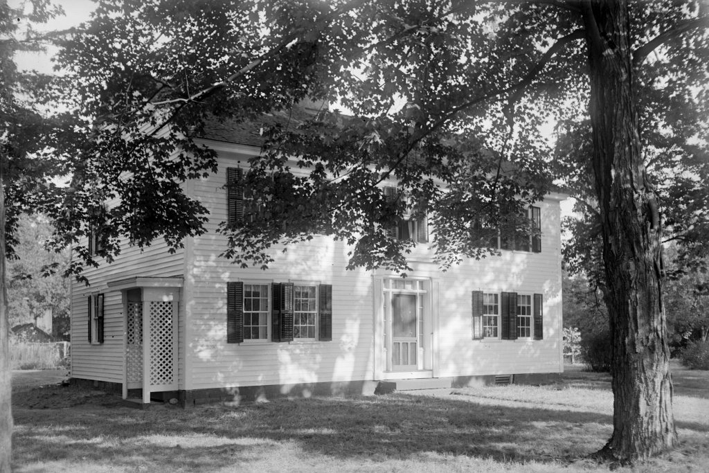
The house at the northwest corner of Longmeadow Street and Emerson Road in Longmeadow, in 1924. Image courtesy of the Longmeadow Historical Society, Paesiello Emerson Collection.
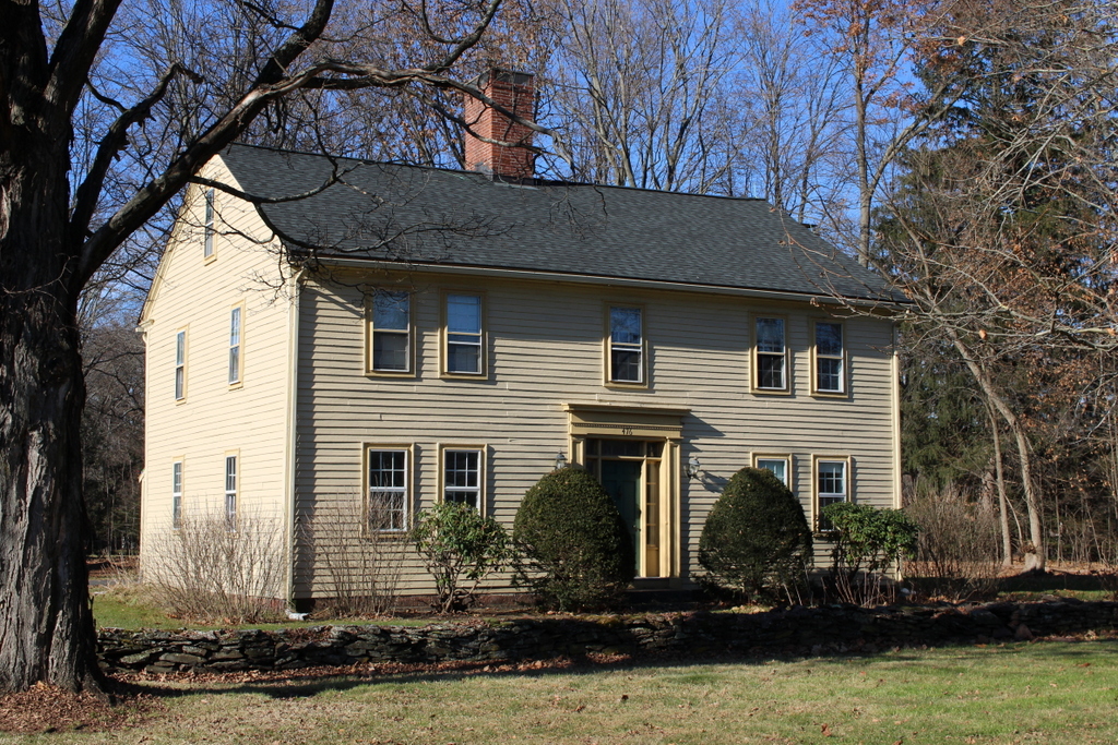
The house in 2023:
The exact date of construction for this house is uncertain, but it has been variously estimated as being anywhere from 1755 to 1775, with 1760 being the most commonly cited date. It was built by Josiah Cooley (1716-1778), but a portion of the foundation is believed to be even older, dating back to perhaps the 1710s or 1720s, when Josiah’s father Eliakim (1681-1758) built a house here on this site. The Cooley family was among the first of the European colonists to settle in the land that would become Longmeadow. Like many of these colonists, they initially settled in the meadows near the Connecticut River, but by the early 1700s they had begun to move up the hill, to modern-day Longmeadow Street.
In 1728, Eliakim Cooley’s house on this site gained attention when it was struck by lightning on May 19. Based on an account that was published in the New England Weekly Journal a little over a month later, the lightning caused considerable damage to the house while also injuring Eliakim and his daughter Griswold Cooley (1709-1764). Eliakim’s injuries were relatively minor, but Griswold never fully recovered, despite living another 36 years after the incident. According to family tradition, this long-term disability was the reason why she never married.
It seems unclear as to exactly what happened to the original house. Around 1750, Eliakim Cooley transferred his property here to his sons Josiah and Hezekiah (1720-1796), and they subsequently divided the land. Josiah received the southern part here where their father’s house stood, and Hezekiah received the northern part. According to tradition, the two brothers then built identical homes on their respective properties sometime around 1755-1760, although it does not seem clear whether Josiah’s house was a completely new structure, or whether he incorporated portions of his father’s house into his own home.
Regardless of exactly when it was built, Josiah Cooley’s house looked very different in the 18th century than it does now. It originally had a saltbox-style design, with two stories at the front of the house and one story in the back. The first floor of the house had two rooms in the front and a kitchen in the back, and there were two bedrooms on the second floor. As was often the case for New England homes of this period, it had a large central chimney, which measured about ten feet square at its base.
Josiah Cooley was a prominent local resident. At the time, Longmeadow was still a part of Springfield, but it was governed by a committee of the precinct, which functioned in much the same way as a town board of selectmen. Josiah frequently served on this committee throughout much of the 1750s and early 1760s, and he often served as an assessor as well.
Josiah Cooley had married Experience Hale (1714-1798) in 1739, probably about 20 years before he built this house. Their first child, a daughter who was also named Experience (1739-1771), was born just five months after the wedding, which likely would have raised a few eyebrows here in their small community. They had six more children: Hannah (1742-1820), Eleanor (1745-1777), Sabinah (1747-1823), Josiah (1749-1824), Rebecca (1752-1775), and Simeon (1755-1757). This was an era of large families and also high infant mortality rates, but remarkably all of their children survived to adulthood except for their youngest, Simeon, who died at the age of two.
Assuming that the 1760 date is accurate, Josiah and Experience were in their early to mid-40s when they moved into this house. All of their surviving children were likely still living here with them at the time, although their four older daughters would all get married in the 1760s and presumably left home afterwards. Their daughter Sabinah married John Keep in 1767, and one of her children was the Rev. John Keep, a prominent 19th century pastor and abolitionist who served on the board of trustees of Oberlin College for many years.
Their oldest daughter Experience died in 1771, and the Rev. Stephen Williams mentioned her death in his diary. Williams (1694-1782) served as pastor of the Longmeadow church from 1716 until his death in 1782, and he kept a detailed diary throughout this time. The Cooley family made frequent appearances in the diary, especially in the early years of his ministry, when the Cooleys, including Josiah’s father Eliakim, opposed Williams’s controversial decision to sing Psalms during Sunday worship services. By the time Experience died in 1771, more than a half century had passed since this theological dispute, but it is hard to tell whether there was any lingering animosity between Williams and the Cooleys. Either way, after Experience’s death Williams paid a visit to Josiah Cooley, presumably here at his house. His diary entry for that day, July 3, 1771, states:
this day I visitd Sergt Jos: Cooley & family (yt have lately burrd a daughtr) they appeard to take ye visitt in good part – the Lord Grant me prudence & discretion, & Grant my visitts may be profitable – & oh yt I might mySelf be Sanctifyd thro out in Spirit, Soul & Body -.
Williams would subsequently make more visits to the house in the early 1770s. By that point, both Josiah Cooley and his youngest daughter Rebecca were in declining health. On May 11, 1772, he wrote “this day I visitd Sergt Jos: Cooley, who is very low, & apprehendd to be near his End – ye Lord have mercy on him.” However, two days later Williams was more optimistic, noting that “Sergt J Cooley may yet live.” That proved to be the case, but in the meantime Rebecca fell ill, and Williams visited her on November 15, 1773. She was 21 years old at the time, but was “indeed in a Low & Languishing State (tis feard is consumptive).” His diary recorded at least three other visits, and she ultimately died on January 21, 1775, at the age of 22. In the meantime, Josiah evidently never fully recovered his health, and he died after having “been Languishing Sometime” on September 7, 1778, at the age of 61.
Josiah Cooley had written his will during his health scare back in May 1772. In it, he left one third of his land, buildings, and household furniture to his wife Experience. Most of his remaining property went to their only surviving son, who was also named Josiah. The younger Josiah would go on to live here in this house for the rest of his life, although in 1777 he gave half of his property and half of this house to his only surviving son, Josiah Jr.
Also in 1777, the younger Josiah married Abiel Bliss (1758-1830) of Wilbraham. They had eight children: Rebecca (1778-1833), John Bliss (1781-1786), Sylvia (1785-1834), Lydia (1787-1823), Lucy (1789-1869), John Bliss (1793-1858), Eliza (1799-1851), and Harriet (1802-1880). All of their children survived to adulthood with the exception of the first John Bliss. He died at the age of five, and his name was subsequently given to their other son, who was born seven years later.
Like his father, Josiah Cooley Jr. was a prominent figure in the local community. He served on the committee of the precinct from 1780 to 1783, just before Longmeadow was incorporated as a separate town in 1783. He also held a number of other town offices over the years, including variously serving as a warden, constable, tithingman, fence viewer, surveyor of highways, field howard, field driver, bull committee member, and school committee member. Throughout this time, he also served a mix of different ad hoc committees, often relating to roads, bridges, and other public works projects.
Aside from his roles in the town government, Josiah Cooley Jr. also served as a soldier during the American Revolution. On April 21, 1775, two days after the start of the war, he was a corporal in a company of Longmeadow minutemen that marched in response to the Lexington Alarm. He did not see any combat, and his service on this particular occasion only lasted for three days. However, he subsequently enlisted as a corporal on September 24, 1777 serving for 32 days in Colonel Charles Pynchon’s regiment during the Saratoga campaign.
Josiah Cooley was living here during the first federal census in 1790. However, prior to 1850 the census did not record names or demographic information about individual people within each household. Instead, only the head of the household was identified by name. The rest of the household members were identified only based on the number of people in each age range, gender, and race. In 1790, there were, including Josiah, a total of two free white males aged 16 and older, one free white male under 16, and seven free female residents. At the time, Josiah and Abiel had four daughters and no living sons, which means that there were four other people living here aside from them and their children. This probably included Josiah’s mother Experience, who was still alive in 1790 and was presumably still residing here at this house.
The next three censuses likewise showed more people living here than just Josiah, Abiel, and their children. They may have included extended family members, or perhaps hired farm hands. For example, in 1820 there was one male aged 10-15, and another aged 16-18. Based on their ages and gender, neither of them could have been Josiah and Abiel’s children.
Josiah Cooley Jr. died on February 13, 1824 at the age of 74, and his daughter Lucy subsequently inherited the house. Lucy had married Luther Colton (1787-1857) in 1809, and they had four children: Luther Woolworth (1812-1851), Francis Stebbins (1815-1815), Lucy Ann (1817-1879), and Josiah Cooley Colton (1825-1895). Francis died in infancy, but their other three children were evidently living here with them in 1830, based on the census records. The 1830 census also shows a woman aged 70 to 79 living here, which may have been Lucy’s mother Abiel. She would have been 72 at the time, although she died in July 1830, only a month after the official census enumeration date.
During Lucy and Luther Colton’s ownership, the house underwent its first major renovation. Some sources say that this occurred in 1827, while others say 1835, but given the scope of the work it is possible that it was a long-term project that took several years to complete everything. The renovations included replacing the old saltbox-style roof with a full second story, along with a two-story wing on the right side of the house. This wing is set back from the front of the main part of the house, so it is not visible from this particular angle in these two photos. The house also has a large one-story addition in the back, which may have been added during this 1820s-1830s renovation.
Aside from expanding the living space in the house, this renovation also included stylistic updates. The house was originally built with 12-over-12 windows, which were typical for homes of the colonial period. However, improvements in glassmaking technology in the early 19th century enabled larger panes, the 6-over-6 windows became the predominant style. Here in the front of the house, the original windows were removed and replaced with 6-over-6 ones, as shown in these two photos. But, many of the old windows were saved and reinstalled in the back part of the house. The shutters were also updated, with the old interior shutters being removed and replaced with exterior ones. According to an early 20th century account, some of the old interior shutters were repurposed as a cupboard.
It was also apparently during this renovation that the original front doorway was replaced with the current one. This style, with the windows above and on either side of the door, and the entablature above it, would not have been original to the house. However, it was popular during the Greek Revival era of the 1820s and 1830s, and many 18th century homes in Longmeadow were updated with doorways similar to this one during the 19th century.
The interior of the house was also updated during this time, particularly in the two front rooms. The intent seems to have been to modernize the more public areas of the house, with less of an emphasis placed on the back part of the house and the second floor. This work included removing the original wainscoting from the front rooms, which was then reinstalled in the newly-created second-floor space.
Part of the reason for these renovations was to accommodate the growing Colton family. In 1835, Luther and Lucy’s oldest son, Luther W. Colton, married Abigail R. Morris (1812-1848) of Longmeadow. The couple moved into this house with Luther’s parents, and they lived in the new wing on the north side of the house.
The older Luther Colton served as a captain in the town militia, and he also held a variety of town offices, including tithingman, surveyor of highways, fence viewer, and fire ward. However, his primary occupation appears to have been farming. In the 1850 census, he owned 30 acres of improved land and another 30 acres of unimproved land, which was collectively valued at $3,000. His livestock included 2 horses, 8 milk cows, 5 other cattle, and 3 swine, and during the previous year his farm’s agricultural output consisted of 80 bushels of rye, 150 bushels of Indian corn, 25 bushels of oats, 150 bushels of Irish potatoes, 500 pounds of butter, and 15 tons of hay.
The 1850 census was also the first to list each individual household member. At the time, Luther and Lucy were both in their early 60s, and both of their sons were also still living here. Luther W. Colton’s first wife Abigail died in 1848, and a year later he remarried to Julia Bliss (1811-1897). They were here during the 1850 census, along with his children from his first marriage, Henry (1837-1888) and Emma (1845-1869). Luther and Lucy’s younger son Josiah was also living here at the time, along with his newlywed wife Nancy Burt (1826-1895).
Luther W. Colton died in 1851 at the age of 38, but his widow Julia and his younger child Emma were still living here with Luther and Lucy during the 1855 state census. Other residents included Julia McDermott, a 23-year-old Irish immigrant who was here with two-year-old John M. McDermott, who was presumably her son. The census does not list her occupation, but she may have been a domestic servant. The other two residents in 1855 were 25-year-old Joseph H. Booth and 21-year-old Isaac W. Coomes. They appear to have been boarders, and they both worked as spectacle makers, which was one of the few industries that existed in the primarily farming community.
Just two years after the census, the elder Luther Colton died at the age of 69. Under the terms of his will, his widow Lucy received the south half of the house, along with “one half of the pantry at the north end of the kitchen. She was also granted the right to use the oven as needed, along with the wood house and cellar. Along with this, she received the south half of the house lot, the south half of the wheat field, and all of his household furniture. She was also allotted one cow, of her choosing. Luther also left bequests of $100 each for his grandchildren Henry and Emma, and the rest of his estate, including the remainder of this house, went to his only surviving son, Josiah Cooley Colton.
Josiah was not living here in the 1855 census, but he evidently returned to care for his aging mother after his father’s death. He was here in 1860, along with his wife Nancy and their children: Charles (1851-1917), Harriet (1856-1905), and Lizzie (1859-1913). The household also included his mother Lucy, along with ten-year-old Julia Gargan, whose relationship to the family seems unclear. They also employed 15-year-old Bridget McMamery, an Irish immigrant who worked and lived here as a servant. The last member of the household was 27-year-old Peter Ward, who was also from Ireland. He was listed as a “laborer,” although it does not seem clear as to whether this means he was a laborer who worked for the Colton family, or whether he worked elsewhere but boarded here at the house.
Unlike the previous generations of his family, Josiah Colton was not primarily a farmer. As was the case with many other men of his generation, he was more interested in the opportunities to be found in manufacturing. The 1860 census listed him as a button manufacturer, probably for the Newell Brothers’ Manufacturing Company here in Longmeadow. This company moved to Springfield in 1863, joining a number of other companies in the rapidly industrializing city. Josiah Colton likewise decided to relocated, and in the spring of 1869 he sold the house and 20 acres of land to Bradford W. Palmer for $4,500.
The sale marked the end of more than a century of ownership by the Cooley-Colton family, and at least five generations of the family had lived here during this span of time. The move may have also contributed to the death of Josiah’s mother Lucy, who was reportedly heartbroken about selling the house that she had lived in for nearly her entire life. She died in August 1869 at the age of 79, only a few months after the move to Springfield.
As it turned out, the Palmer family only lived here for three years, before selling it in 1872 to William G. Emerson (1806-1887). He was a carpenter, and he was originally from eastern Massachusetts, but had moved to Holyoke in 1848 to work on the construction of the dam and mills there. He later moved to Springfield, before eventually buying this house in Longmeadow. His first wife Susan had died in 1843, but he subsequently married his second wife, Lovina Fay, in 1847.
By the time Emerson purchased this house, the children from his first marriage had either died or were living on their own. However, he and Lovina had three younger children of their own: William (1849-1930), Annie (1859-1941), and Henry (1865-1943). It does not seem clear whether the younger William lived here in this house with his parents, or if he was already living on his own by 1872, but the two younger children were both living here with William and Lovina during the 1880 census.
Of all the many residents of this house over the years, perhaps none were as instrumental in preserving the house and its history as William’s daughter, Annie Emerson. She was a public school teacher, but she was also the de facto town historian here in Longmeadow, and she did extensive work with the Longmeadow Historical Society. As part of this, she produced a detailed written history of this house, which is now in the archives of the Historical Society. That document was a particularly helpful source for this post, particularly in providing dates and other specific information on major alterations to the house.
Annie’s father William died in 1887, and her mother Lovina died a decade later. By the 1900 census, Annie and her younger brother Henry were the only family members still living her. Neither of them ever married, and they both lived in this house for the rest of their lives. Henry was a farmer, specializing in raspberries and asparagus. According to his obituary, he was one of the largest growers of raspberries in western Massachusetts. Later in life, he shifted his focus to poultry and eggs, and he appears to have been the last of a long line of residents to operate a commercial farm here on the property.
In 1907, Annie and Henry were joined here by their half brother Paesiello Emerson (1832-1927). He was the eldest child from their father’s first marriage, and at the age of 75 he was significantly older than his half siblings. Originally from Hopkinton, Paesiello later lived in Spencer and Ashland. He married Nancy Hartshorn (1828-1891) in 1855, and later served in the Civil War in the 5th Massachusetts Battery, from 1863 to 1865. During this time, he was wounded in action on June 8, 1864, at the Battle of Cold Harbor. An artillery shell injured his hand, and he carried the scar from it for the rest of his life. However, he recovered from his wound, and continued to serve until the end of the war.
Paesiello Emerson’s primary occupation was as a boot maker, but later in life he took up photography as a hobby. He started around 1902, when he was about 70 years old, and by the time he moved to this house he was already an accomplished amateur photographer. Despite his age, he would continue his photography here in Longmeadow for the next two decades, eventually amassing a portfolio of about 1,500 glass plate negatives. The majority of these were taken in Longmeadow, and they are a valuable resource for studying the history of the town and its development at the turn of the 20th century. Because he lived here in this house, it was a frequent subject for his photographs, including the first one here in this post, which he took when he was about 92 years old.
Aside from photography, Paesiello Emerson’s other hobbies included travel. Even when he was well into his 70s and 80s, he was still regularly traveling to far-off destinations, including Bermuda, Panama, and California. He also regularly attended Civil War reunions, including one in Fairhaven, Massachusetts in 1927, when he was 95 years old. His family had been opposed to him attending the previous year’s reunion because of his advanced age, so this year he slipped out of the house without telling anyone, prompting the publication of missing persons articles in several newspapers. His sister Annie eventually tracked him down, leading to a follow-up article in the New Britain Herald that stated he “was well enough to sit down and find pleasure in reading newspaper accounts of his reported disappearance.”
As it turned out, that reunion would be his last, and he died a few months later in December 1927. Annie later donated his entire collection of glass plate negatives to the Longmeadow Historical Society, which has since digitized them and made them available online via the Digital Commonwealth website.
In the meantime, by the 1930 census both Annie and Henry were still living here, as was their older brother William F. Emerson. William does not appear to have moved into this house until relatively late in life. He spent most of his life in Longmeadow, including serving for many years as town clerk, and he also served a term in the Massachusetts House of Representatives in 1912. However, he lived elsewhere in town until sometime around the mid-1920s, when he moved in with his siblings here in this house. He was definitely living here by 1927, and was apparently estranged or divorced from his wife Juliet, who was living in New Jersey by 1930.
William F. Emerson died here at the house in December 1930, at the age of 81. His two younger siblings would continue to live here into the 1940s, until Annie’s death in 1941 at the age of 81, and Henry’s in 1943 at the age of 77. The youngest and last surviving of all his siblings, Henry had been only six years old when he moved into this house, and he had spent the next seven decades of his life living in this house and working in the fields behind it.
The Emerson family does not appear to have made any significant changes to the house during their 71 years of ownership, but the subsequent owners in the 1940s and 1950s both modernized and restored parts of the house. It was during this time that two bathrooms were added to the back part of the second story, and the central heating system may have also been installed around the same time. Other interior work during included restoring the wainscoting to its original location in the front rooms, along with replacing the doorknobs with the older-style door latches and hinges.
These mid-20th century renovations also included exterior work. The 19th century shutters, which appear in the first photo, were evidently removed around this time, as was the “coffin door” on the left side. At some point in the 20th century a two-car garage was built into the wing in the back of the house, in an area that had evidently once been a shed. Other changes, which likely occurred in the late 20th century, included the addition of a sunroom on the back of the house.
However, despite several major renovations in the 19th and 20th centuries, the house is still remarkably well-preserved, with a significant amount of original material. The 6-over-6 windows from the 1820s-30s renovation are still installed here, while the back of the house still has many of the original 18th century 12-over-12 windows. On the interior, the original central chimney still stands, and most of the rooms feature original wide pine boards and wood paneling. Overall, it stands as an excellent example of an 18th century colonial home, and it is one of the many historic properties that still line Longmeadow Street.