Main Street, Laconia, NH (2)

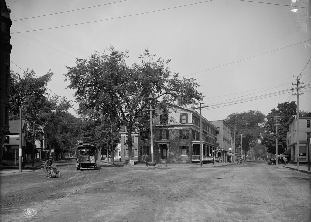
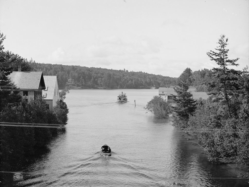
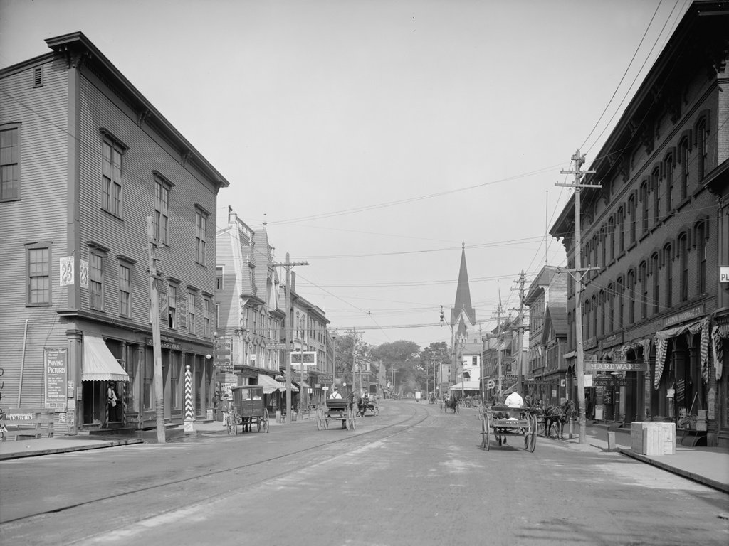
Looking north on Main Street from the bridge across the Winnipesaukee River in Laconia, probably in 1907. Image courtesy of the Library of Congress, Detroit Publishing Company Collection.

972_1900-1910 loc

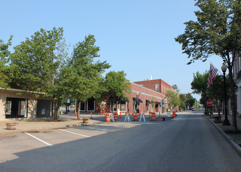
Main Street in 2016:

972_2016
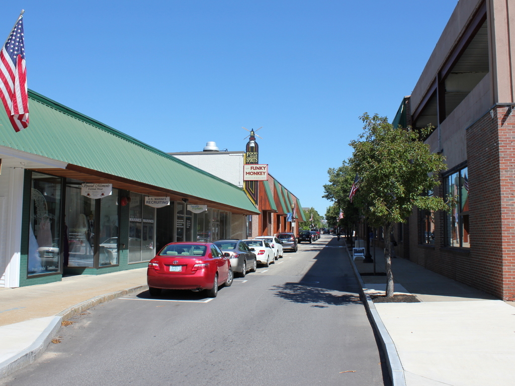
This scene is a perfect example of urban renewal gone horribly wrong. What had once been a vibrant downtown with a variety of 19th century architecture was completely leveled in the 1960s, and it was replaced with nondescript one-story commercial buildings to the left and a parking garage on the right. Even the streets themselves were dramatically changed, with bizarre traffic patterns and an extremely narrow, one-way street here that looks more like a back alley than a Main Street.

The first photo is far more interesting than the present-day scene, and it was probably taken around the same time as the one in this earlier post, which shows the same view from about 150 yards further up Main Street. Some of the downtown businesses in this view include several drugstores, hardware stores, tobacco shops, and confectioneries, along with a photographer, tailor, paint store, sporting goods store, baker, harness maker, and a horse shoer. There are several advertisements posted on the building on the left side of the photo. One of them is a poster for the Cole Bros. Circus on Tuesday, July 23, which helps to establish the 1907 date since that day was a Tuesday in 1907. Below it is a larger advertisement for Folsom Opera House, which reads: “A Genuine Treat. The most perfect Moving Pictures ever examined. All the latest and best films including the funny chase pictures and animated pantomimic dramas. Wonderful Realism.”

Most of the buildings from the first photo were still standing by the 1950s, as seen in a photo on this Weirs Beach website. However, nothing in the block between Beacon and Pleasant Streets is still standing today, and most of the buildings further in the distance are also gone, although some were demolished before the 1960s redevelopment. The Eagle Hotel at the corner of Main and Pleasant Streets was demolished in the 1930s, and the Unitarian Church across the street from it, whose steeple is visible near the center of the photo, was destroyed by a fire in 1938. At least one brick building, barely visible on the left side near the center of the photo, is still standing. Nearly 250 yards away from the camera, this is the only identifiable building left from the 1907 scene along this section of Main Street.

Main Street, Laconia, NH

Looking north on Main Street in Laconia at the intersection of Pleasant Street, probably in 1907. Image courtesy of the Library of Congress, Detroit Publishing Company Collection.

608_1908c loc

Main Street in 2015:

608_2015
As far as I can tell, only one building from the first scene survives today: the brick building on the left side of Main Street, just to the right of the center in both photos.  As was the case in many other parts of the country during the 1960s, a number of Laconia’s historic downtown buildings were destroyed as part of an urban renewal project.  However, the most prominent building in the first scene, the Eagle Hotel, was gone before then.  It enjoyed a prominent location right at the intersection of Main and Pleasant Streets, and was just a block away from the railroad station.  Around the time that the first photo was taken, it was one of Laconia’s most popular hotels (and, at $2.50 a day, one of its most expensive as well).  By the 1950s, the former hotel had been demolished and replaced by Woolworth’s, as seen in some of the pre-urban renewal photos featured on this Weirs Beach website.  Today, the site is occupied by a one story brick building with commercial storefronts.  This might be the same building that Woolworth’s was once in, but if so it has been heavily modified over the years.

Part of the urban renewal projects involved changing some of the traffic patterns in downtown Laconia.  Today, Main Street south of here (behind the photographer) is a narrow, single lane one way street that carries northbound traffic.  The buildings on the left-hand side of the street in that section extend about 40 feet closer to the center of the road than the pre-renewal buildings did.  In this scene, the road is as wide as it was a century ago, but it still has just one way northbound traffic, with angled on-street parking taking up what was once the southbound travel lane.  Pleasant Street is now one way, southbound, and any traffic on the street must circle around the former Woolworth’s site and head back north on Main Street.

Although the first scene is mostly deserted, there are a few interesting things going on.  The man on the far left appears to be a street sweeper; he is pushing what looks like a large, wheeled canvas bag while holding a broom and probably a pick.  He is looking at the ground, and it seems like he is about to walk into the path of the oncoming trolley.  The trolley has a handbill on the front, advertising for “Adrift in New York,” which would be showing at the Moulton Opera House on Tuesday, September 17.  The Library of Congress estimates that the this photo was taken in 1908, but September 17 fell on a Tuesday in 1907, so the photo was probably taken in early to mid September of that year.  Plays weren’t the only form of entertainment that was available at the Moulton Opera House, though; a sign on the sidewalk reads “Don’t Fail to See the Great Moving Pictures Tonight.”  The “moving pictures” would have been early silent films, most of which were not preserved and have long since been lost to history.  Likewise, the trolleys have been lost to history; the Laconia Street Railway shut down in 1925 amid growing competition from cars and buses.

Railroad Station, Laconia, NH

The Laconia Passenger Station, around 1900-1910. Image courtesy of the Library of Congress, Detroit Publishing Company Collection.

607_1900-1910 loc

The station in 2015:

607_2015
Because railroads were the dominant form of transportation in the second half of the 19th century, a city’s railroad station was usually the first thing that visitors saw. As such, it was important to make a good first impression, so in 1892 Laconia’s previously humble railroad station was replaced by a far larger, more impressive one.  It was designed by Bradford Gilbert, who drew heavily on the Romanesque style that had been made popular by recently-deceased architect Henry Hobson Richardson.  In fact, the Laconia station bears some resemblance to the old Union Station in Springfield, Massachusetts, which had been built three years earlier by Richardson’s successors at Shepley, Rutan and Coolidge.

The station was owned by the Boston and Maine Railroad, and it was located on the main route to Lake Winnipesaukee and the White Mountains.  However, with the decline of passenger rail by the mid 20th century, the station eventually closed.  Boston and Maine ran their last passenger train through here in January 1965, and since then the building has been used for a variety of purposes, from a police station and courthouse to offices and stores.  Today, it relatively unaltered from its appearance over a century ago, and it is listed on the National Register of Historic Places.

Paugus Bay, Weirs Beach, NH

Looking south toward Paugus Bay in Weirs Beach, from the present-day Route 3 bridge, around 1906:

588_1906c loc

Paugus Bay in 2015:

588_2015
This channel is the place where water flows out of Lake Winnipesaukee through Paugus Bay and eventually to the Merrimack River.  Originally, Paugus Bay was at a slightly lower elevation, and the channel was used by Native Americans for fishing.  They built stone weirs in a “W” shape across the channel to catch shad as they migrated from Winnipesaukee toward the ocean.  However, by the 19th century a dam was built in Lakeport, which raised Paugus Bay to the same level as Lake Winnipesaukee and flooded the old weirs.  Later on, the channel was dredged to allow navigation, effectively making Paugus Bay a part of Lake Winnipesaukee.

When the first photo was taken, this area was a popular tourist destination, and that has only increased over the years.  As seen in the two photos, the waterfront has become significantly more developed, especially on the right-hand side of the channel, which is now occupied by a number of boathouses.  I’m not sure if any of the buildings from 1906 are still around today; the ones on the left are clearly gone, but some of the boathouses in the distance on the right might survive, although it is hard to tell.  It is entirely possible that some of the cottages in the distance beyond the channel might still exist, but with the tree cover it is hard to tell from here.

Weirs Beach, NH

The shoreline of Lake Winnipesaukee at Weirs Beach, around 1906. Image courtesy of the Library of Congress, Detroit Publishing Company Collection.

587_1906c loc

The beach in 2015:

587_2015
Both of these photos were taken from Endicott Rock, a state park that features a beach and a rock that dates back to possibly the earliest European explorers to reach Lake Winnipesaukee.  When Massachusetts was first colonized, their charter defined the colony’s boundaries based on two largely unexplored rivers: the Charles, and the Merrimack.  The colony would have control over all of the land from three miles south of the southernmost bend of the Charles River, to three miles north of the northernmost bend of the Merrimack River.  Both of these rivers flow roughly southwest to northeast in present-day Massachusetts, and for the southern end this was pretty straightforward; the Charles River’s southernmost bend is in the town of Bellingham, and the current southern border of Massachusetts is roughly based on that location.

For the northern border, however, things became a little more complicated.  As it turned out, the Merrimack River does not flow primarily west to east; just to the west of Lowell it makes a sharp turn to the north, and continues almost due north, well into New Hampshire.  In 1652, Massachusetts governor John Endicott sent a group of explorers to find the source of the river.  They reached the waters of Lake Winnipesaukee here at present-day Weirs Beach, and determined it to be the headwaters of the Merrimack River.  They calculated the latitude to be 43 degrees 40′ 12″ north (which was, impressively, off by only about 4.5 miles), and carved the date, the initials of Governor Endicott, and the initials of the rest of the surveyors into a rock along the water, declaring all of the land south of that line of latitude and west of the Merrimack River to be part of Massachusetts.

Although this was an apparent windfall for Massachusetts, it caused controversy between them and New Hampshire, as this border would have given Massachusetts a sizable chunk of present-day New Hampshire.  In fact, though, the actual source of the Merrimack River is much further north, at the headwaters of the Pemigewasset River at Franconia Notch, which means if the original charter was still in effect today, New Hampshire’s iconic Old Man of the Mountain would have been in Massachusetts.  However, since neither Franconia Notch nor Lake Winnipesaukee would have been reasonable boundary locations, given the intent of the original charter, the border dispute was settled in 1740 by King George II, who declared that the border would run three miles north of the Merrimack River until Pawtucket Falls (present-day Lowell), and then a straight line to the Massachusetts-New York border.

In the ensuing years, Endicott Rock lapsed into obscurity, until it was rediscovered in the first half of the 19th century.  An enclosed structure was later built around it, and today it can still be viewed at Weirs Beach, although it is not visible in these two photos here; they were taken right near the rock, but facing away from it.  Much of Weirs Beach has changed over the years, including the beach itself, which is now much wider and sandier than in 1906.  The area saw several devastating fires over the years, including one that destroyed the S.S. Mount Washington, seen steaming away from the dock on the right-hand side.  However, the Mount Washington‘s successor can be seen in the 2015 photo, docked in the right center area, and many of the historic Veterans’ Association buildings along Lakeside Avenue survive today.

Steamboats on Lake Winnipesaukee in Weirs Beach, NH

The S.S. Lady of the Lake at Weirs Beach, around 1865. Image courtesy of the New York Public Library.

586_1865c nypl

The S.S. Mount Washington approaching the same pier around 1906. Image courtesy of the Library of Congress, Detroit Publishing Company Collection.

586_1906c loc

The M.S. Mount Washington at the same location in 2019:

Lake Winnipesaukee is the third largest lake in New England, and the second largest entirely within the region (Lake Champlain, located on the border of Vermont and New York, is larger than the next 9 largest combined).  Like Lake Champlain, Winnipesaukee has seen a number of steamboats over the years, with one of the first being the Lady of the Lake, which was completed in 1849 and is seen in the first photo.  In the days before automobiles, the easiest way to access most of the towns on the lake was by boat, and much of this traffic in the mid 19th century was carried by the Lady of the Lake.  Here in Weirs Beach, visitors arrived by train to the depot just behind the photographer, and then boarded the steamer to travel to their destination.  The glory days of the Lady of the Lake lasted until 1872, when the larger, faster S.S. Mount Washington entered service.  The older ship continued to operate in a losing battle to compete with the Mount Washington, until she was taken out of service in 1893.  Two years later, she was filled with rocks and sunk, and today the wreck is a popular dive site.

Meanwhile, the Mount Washington continued to be the preferred method of transportation around the lake until the 1920s, when larger numbers of tourists began traveling by automobile.  As a result, the ship’s owners, the Boston & Maine Railroad, sold her to a new owner, who marketed the ship as a tourist attraction instead of simply a method of transportation.  It was a success, and the ship operated until 1939, when a fire at Weirs Beach destroyed the ship, along with the dock, the railroad depot, and the boardwalk.

In 1940, the ship’s owner purchased the S.S. Chateaugay to replace the Mount Washington.  Built in 1888, the Chateaugay was a sidewheel steamboat on Lake Champlain, so transporting it to Winnipesaukee required cutting the hull into 20 pieces and shipping them by rail, where they were reassembled in Lakeport.  Only the hull itself was used; everything else, including the superstructure and even the propulsion system, was replaced.  Renamed the Mount Washington, the rebuilt ship made her first voyage on the lake in August 1940, and has been used for sightseeing cruises ever since.  Aside from the 1940 reconstruction, the ship has been altered several other times, including in 1942, when the steam engines were removed for the war effort.  After the war, the ship was fitted with diesel engines, which in turn were replaced in 2010.  The other major change happened in 1982, when the ship was cut in half and a new 20-foot section of hull was added in the middle.  Because of all of this, the 127-year-old ship bears essentially no resemblance to what she looked like when used as the Chateaugay; the photo below, courtesy of the Library of Congress, Detroit Publishing Company Collection, shows the Chateaugay plying the waters of Lake Champlain around 1910-1920:

586_1910-1920 loc same ship, but on lake champlain