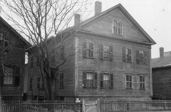
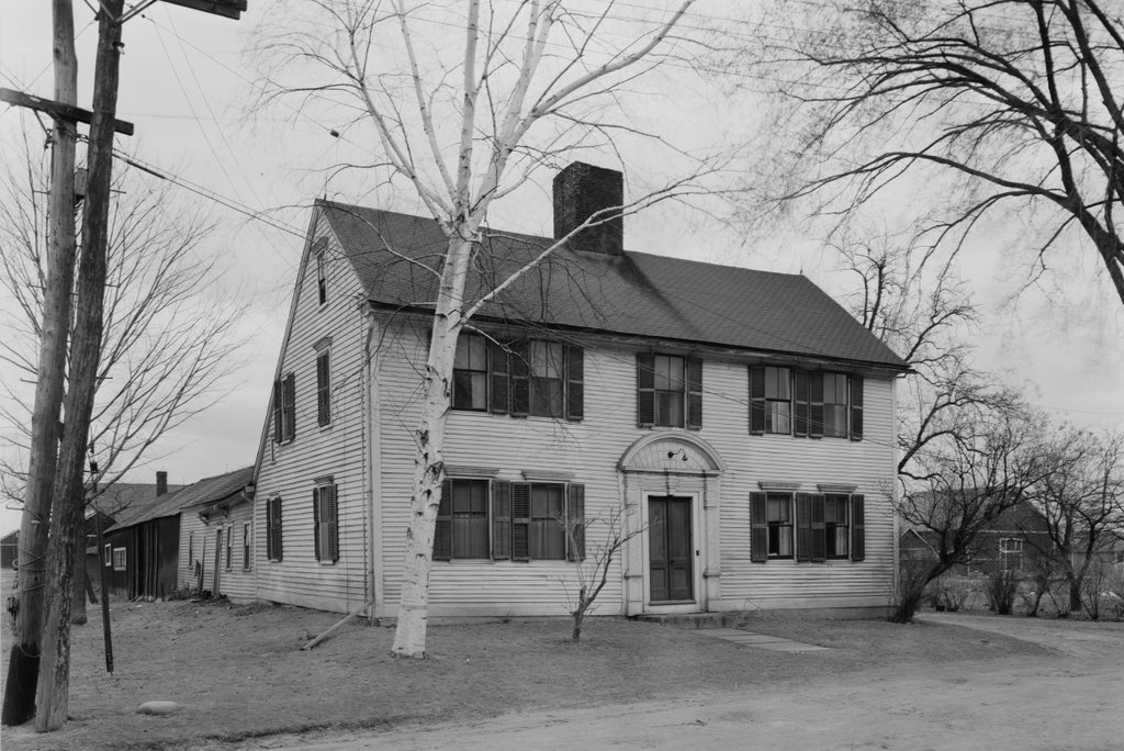
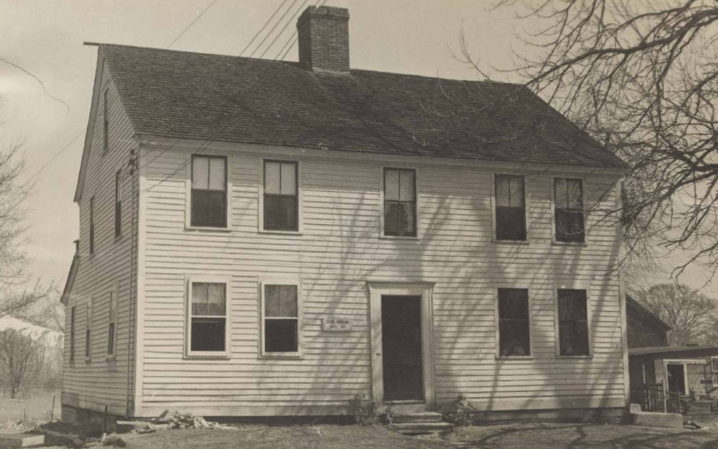
Martindale Farm, Ware, Massachusetts

The Martindale Farm in Ware (formerly Enfield), Massachusetts, on April 6, 1946. Image courtesy of the Metropolitan District Water Supply Commission, Quabbin Reservoir, Photographs of Real Estate Takings collection.

The scene in 2024:

This house, located on Webster Road in the town of Enfield, Massachusetts was built around the year 1800 by Jesse Fobes. Jesse moved to Webster Road in 1796 from Bridgewater, MA into a smaller house just north of this property. Once this home was completed, he would move his family to the much larger farm house. When Enfield became an incorporated town in 1816, Jesse would serve as one of its first Selectmen. Ownership of the farm would be passed onto Jesse’s son, Henry Fobes. Much like his father, Henry would also become a Selectmen of the town. Henry would hold onto ownership of the farm until selling it to Joel and William Martindale in 1870 for $8,000. Included in the sale of the farm was a provision that the Martindale’s would have to house and feed Henry until his death. Considering Henry lived another 15 years until dying at the age of 92 in 1885, it seems like Henry got the better end of the deal.

By the 1880s, the farm had a considerable amount of outbuildings. On the 182 acre property were a large carriage shed, garage, hen house, brooder house, three barns, and an assortment of other smaller chicken coops. Joel Martindale would officially call the farm Maple Terrace, in reference to the three terraces that lead up to the front of the house. A sketch of the farm house with its terraces and some outbuildings was even included in the 1879 book History of the Connecticut Valley in Massachusetts. Maple Terrace had become something of a local landmark by this point.

The farm would pass into the hands of Joel’s grandson, Emory Bartlett in 1917. He would drop the Maple Terrace name, and officially incorporate the farm as Martindale Farms Inc. But the glory days of the farm were farm behind at this point. Only a few years later, Emory would sell the farm to Harry Ryther in 1925 as payment for a large debt.

Because of its proximity to the Quabbin Reservoir watershed, the Massachusetts Metropolitan District Water Supply Commission purchased the house and the 182 acres it sat on from Harry Ryther in 1934 for the sum of $11,900. Two Martindale sisters were still living in the farm house when the Water Supply Commission purchased the property.

Martha and Mary Martindale were daughters of Joel Martindale, and both had lived in the house almost their entire lives. This led to debate as to whether or not the home should be torn down. The home appears to be right on the line of the watershed, so some thought the house should stay up and be used as employee housing. Others believed the home was still too close to the reservoir, and should be torn down immediately. An agreement was reached with the Water Supply Commission that allowed the Martindale sisters to live in the home until they either died or moved away. During that time, the home would also be used by Quabbin employees.

Mary Martindale would die in 1952 at the age of 77. Her sister, Martha would decide to move out of the large home into a smaller apartment in Springfield in 1955 so she could be closer to her remaining friends and family. Martha Martindale would be the last private resident to live inside the boundaries of the Quabbin Reservoir land. The home was torn down shortly after, and the landscape allowed to go wild. Building materials from the home were reported as being reused in a future home in the area.

The before photo was taken in 1946, much later than many of the Water Supply Commissions photos of old Quabbin homes. At this point, the reservoir was already fully flooded and the home was now located in the town of Ware, following the disincorporation of Enfield in 1938. Today, the terraces to the home are still clearly visible when you visit the farm. The home’s cellar hole is completely filled in, and much of the yard is overgrown with brambles and vines. The foundations for the outbuildings are easily found out of frame to the right of the photo. Walking down the old driveway leads to the foundations of the barns, as well as some stone walls. The tree to the left of the house in the before photo is almost certainly the same tree on the far left of the current photo. Other old trees can be seen today that would have been very young at the time the home was sold to the Water Supply Commission.

The Martindale Farm is one of the best and most easily accessible spots in Quabbin for history lovers. Located near the end of Webster Road through Gate 53, the old farm is located in a large clearing on the west side of the road. In the summertime, Quabbin rangers will sometimes do history programs at this location and go into greater detail on who the people were that owned this farm.

Buttolph-Williams House, Wethersfield, Connecticut (3)

The east side of the Buttolph-Williams House in Wethersfield, in August 1938. Image courtesy of the Library of Congress, Historic American Buildings Survey Collection.

The house in 2024:

These two photos show the east side of the Buttolph-Williams House. Built around 1711, the house is one of the oldest in Wethersfield, and it is one of the many historic homes that line the streets of the town center. The top photo was taken as part of the Historic American Buildings Survey in 1938, and by this point the house had undergone many alterations from its original appearance, including newer windows and clapboards, and an ell on the back of the house.

At the time that the top phot was taken, the house was the home of siblings Kate and Frank Vibert. They had grown up in the house in the late 19th century, and they lived here until their deaths in the 1940s. The house was then acquired by the Connecticut Antiquarian and Landmarks Society—now known as Connecticut Landmarks—and it was restored to its original appearance in the late 1940s. This included re-installing diamond-paned casement windows, removing the rear ell, and removing the newer clapboards that had covered the original second-story overhang.

The house was once believed to have been built in the 1690s, but subsequent research has shown that it was actually built around 1711. Either way, though, it has many of the post-medieval architectural elements that were common on 17th century New England homes, and it survives as an excellent example of a First Period House. It is still owned by Connecticut Landmarks, and it is operated as a museum by the nearby Webb-Deane-Stevens Museum.

Granite Railway Incline, Quincy, Massachusetts

The Granite Railway Incline on Granite Rail Court in Quincy, Massachusetts, in April 1934. Image courtesy of the Library of Congress, Historic American Buildings Survey Collection.

The scene in 2021:

These two photos show the Granite Railway Incline, an important civil engineering landmark from the early days of railroads. It opened in 1830 as a branch of the Granite Railway, a 3-mile-long horse-drawn railroad that is often regarded as the first commercial railroad in the United States. The railroad itself had been established four years earlier, in 1826, for the purpose of supplying granite for the construction of the Bunker Hill Monument. The original 1826 route of the railroad extended about three miles from the Quincy quarries to the wharves on the Neponset River, and from there the quarried stone was transported by boat to Charlestown.

Prior to its construction, there had been a few small railroads in Britain and the United States, and there were even some early steam locomotives that had been developed, but the long-term viability of railroads was still very much uncertain in 1826. The Erie Canal had been completed just a year earlier, and many Americans viewed long-distance canals as the future of transportation. Nonetheless, the engineer for this project, Gridley Bryant, set out to build a horse-drawn railroad. And, because railroad technology was still in its infancy, he had to essentially design it from scratch. As a result, he is credited with developing turntables and switches, among other railroad innovations. He also had to design his own rails, which were made of wood and topped with iron straps except for at road crossings, where the rails were granite and iron.

The Granite Railway opened on October 7, 1826, and over the next few years it overcame skepticism as it steadily delivered cut granite blocks to the wharves on the river. Then, in 1830 Bryant expanded the railroad with a short branch that connected it to the Pine Hill Quarry. Because of the elevation change, this involved constructing a large inclined plane up to the quarry, as shown here in these two photos. In total, it was 315 feet long, and rose 84 feet in elevation, for an average grade of nearly 27%. This is significantly steeper than a conventional railroad, and by way of comparison it is even stepper than the average grade of the Mount Washington Cog Railway, although obviously much shorter. And, because of the need for durable materials here on the slope, Bryant constructed it of granite rails with iron straps, rather than the wooden rails that were used on most of the other sections of track on the railroad.

The inclined plane was built with two parallel sets of track, one for ascending cars and one for descending ones. In the center of each track was a chain that ran on pulleys. It formed a continuous loop up and down the inclined plane, pulling the empty cars up the hill while also controlling the descent of the fully-loaded cars that were leaving the quarry. Bryant later described the operation of the inclined plane in a letter that he wrote in 1859 to Charles B. Stuart:

It had an endless chain, to which the cars were attached in ascending or descending; at the head of this inclined plane I constructed a swing platform to receive the loaded cars as they came from the quarry. This platform was balanced by weights, and had gearing attached to it in such a manner that it would always return (after having dumped) to a horizontal position, being firmly supported on the periphery of an eccentric cam. When the cars were out on the platform there was danger of their running entirely over, and I constructed a self-acting guard, that would rise above the surface of the rail upon the platform as it rose from its connection with the inclined plain, or receded out of the way when the loaded car passed on to the track; the weight of the car depressing the platform as it was lowered down.

Overall, it was an important technological innovation, but the inclined plane also became the site of one of the first fatal railroad accidents in American history. This occurred on July 25, 1832, when a group of four visitors ascended an empty car. On the way up, the chain broke, sending the car on an uncontrolled descent. The resulting derailment killed one passenger and seriously injured two others, as described in an article published in the next day’s Boston Evening Transcript:

Yesterday a party of four Gentlemen, boarders at the Tremont House, consisting of Messrs Andrew E. Belknap and John G. Gibson of this city,—Mr Thomas Backus of St Jago de Cuba, and Wm B. Bend of New York, (formerly of Baltimore) rode out to the Quincy Rail-way. Whilst ascending the inclined plane, near the Granite quarry in one of the cars, and when near the summit, the chain parted and the car descended with frightful rapidity.

The force with which it struck the resting place, at the foot of the declivity, was so great that the car and passengers were thrown by the percussion twenty feet into the air, from whence it fell down a precipice of more than thirty feet, amongst the rocks beneath.

Mr Backus was killed instantly. Mr Bend had three ribs broken, and the sinews of a leg parted. Mr Gibson’s head was fractured, jaw broke, and leg broke. Mr Belknap escaped without injury to his bones, but his body is severely bruised.

Messrs Gibson and Bend are at the Railway House, too ill to be removed. Mr Belknap has returned to the city. Mr Backus, we understand, was to be buried this afternoon at Quincy Church. The plane which they were ascending is said to be inclined at angle of nearly forty degrees; and it is supposed that when the car struck, it must have acquired a velocity of sixty miles an hour.

Aside from this accident, the inclined plane appears to have had a good safety record, and it remained in use into the 20th century. The Granite Railway was eventually acquired by the Old Colony Railroad in 1871, and most of the old track was upgraded. However, the inclined plane was too steep to operate steam trains on, so it remained in use in its original configuration until 1901, when modern rails were laid atop the granite track.

It underwent more changes in 1920, when the 1901 rails were removed and replaced by metal channels, which enabled it to be used by trucks. The top photo shows these channels, along with a pair of obelisks that were installed at the base of the inclined plane in 1921 in order to commemorate its role in the early history of railroads.

The inclined plane remained in use until the 1940s, but at some point the upper part of it was removed during quarrying operations. As a result, only the lower portion of it still exists, as shown in the bottom photo. The quarry at the top of the hill eventually closed in 1963, and in 1985 the site of the quarry was acquired by the Metropolitan District Commission.

Today, the old quarry and the inclined plane are part of the Quincy Quarries Reservation. Although significantly smaller than it had been when the top photo was taken, the inclined plane is nonetheless the best-preserved remnant of the old Granite Railway. It still features the old granite rails, some of the iron straps atop them, and the old pulleys. Because of its historic significance, the inclined plane was added to the National Register of Historic Places in 1973, and it survives as an important landmark from the early days of railroad development.

Ezekiel Keith House, Springfield, Massachusetts

The house at 258 Mill Street in Springfield, around 1938-1939. Image courtesy of the Springfield Preservation Trust.
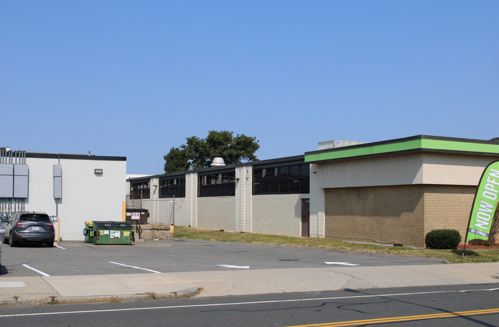
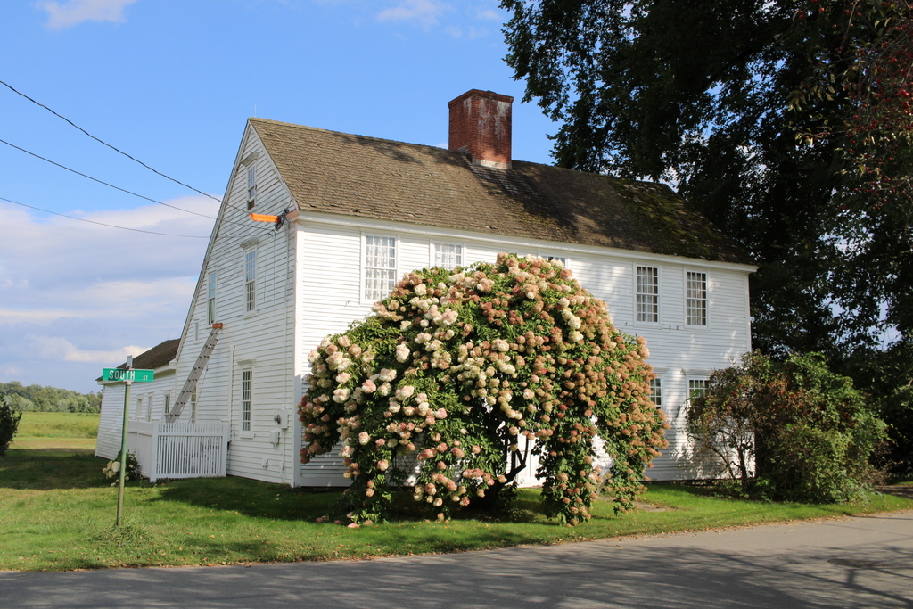
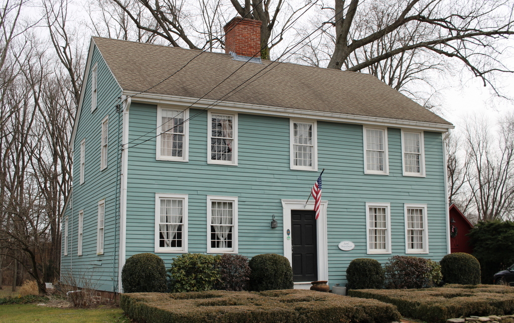
The house in 2023:

Springfield was established by colonial settlers in 1636, making it by far the oldest community in Western Massachusetts. However, unlike nearly all of the other cities and towns in the area, it does not have any surviving buildings that have been verifiably traced back to the colonial period. Most of the colonial-era houses in Springfield were demolished during a period of rapid population growth in the late 19th and early 20th centuries, and today there are only a few dozen buildings that predate 1850, with none that can be confidently dated prior to 1800.

Despite this apparent lack of early buildings, many of the older houses in Springfield have not yet been extensively researched, so it is possible that there might be at least a few 18th century homes still standing in the city. Most of the prominent colonial-era homes in Springfield were located along the Main Street corridor, which was heavily developed and redeveloped many times over the course of the 19th, 20th, and 21st centuries. As a result, there are clearly no 18th century buildings still standing in the downtown area, but it is possible that some might still exist in the outlying areas, which experienced less development pressure over the years, and where individual buildings were not necessarily as well documented by past historians, who tended to focus on the downtown area.

There are several houses in particular that warrant further research, but perhaps the single strongest contender for the title of oldest building in the city is the house shown in these two photos, which stands at the northeast corner of Mill and Knox Streets. The early history of this house has not yet been fully traced, and the interior architecture does not appear to have been studied yet, but the exterior appearance of the house seems to suggest that it was constructed at some point in the second half of the 18th century. Important clues include the spacing of the windows, the steep roof, and the slightly overhanging second story, all of which were typical for houses of that period.

The earliest documented owner of this house is Ezekiel Keith, who was shown as living here on the 1835 map of Springfield. Keith was born in Canton, Massachusetts around 1778, but he was in Springfield by 1806 when he married Elizabeth Ashley. It is possible that this house was built around the time that they were married, but based on its architecture it seems more likely that it was built a few decades earlier.

The house remained in the Keith family throughout the first half of the 19th century. Elizabeth died in 1825, and four years later Ezekiel remarried to Mary Barber. He died in 1846, but Mary outlived him by many years and apparently lived in this house until her death in 1873.

During their many decades of ownership here, the Keith family would have seen many significant changes to the surrounding area. The house is located on a hill just a few hundred feet to the north of the Mill River, near where the modern-day Mill Street crosses the river. Ezekiel’ death records indicate that he had been a farmer, so it seems unclear as to whether he was involved in any of the manufacturing that occurred along the river, but during the first half of the 19th century this section of the river developed into an important industrial center.

The Mill River is the only major source of water power that is entirely in Springfield, so a number of factories were built along its banks, including the Armory Watershops, where much of the heavy manufacturing for the U.S. Armory occurred. The Watershops were originally located on three separate sites along the river, including the Middle Watershops, which were just a little further upstream from the Keith house. Downstream of the house, on the other side of Mill Street, were the Ames Paper Mills, which had been established by former Armory superintendent David Ames.

Census records prior to 1850 do not provide much information about exactly who was living in a particular house, but starting in 1850 the census recorded the names and demographic information of every household member. Here in this house, Mary Keith was living here with a large family. Two adult children from her first marriage, John Barber and Lucia Alden, lived here, as did her stepdaughter Olive Keith. The household also included Lucia’s husband Elijah Alden, and their children Lucia, Louisa, and Joel. Elijah worked as a carpenter, while John Barber was listed as being a gunsmith, probably at the nearby Armory Watershops.

After Mary’s death in 1873, her son John continued to live here. The 1880 census shows him here with his wife Harriet and a boarder, Dr. James W. Wicker. It seems unclear as to exactly what Dr. Wicker’s relationship to the Barbers was, but John died in 1887 and three years later Dr. Wicker married Harriet. He died in 1908, and Harriet died in 1916, ending about a century of ownership by the Keith/Barber families.

The house was subsequently owned by Walter and Otillie Cowles. They were living here by about 1918, and they initially rented the house before purchasing it in the early 1920s. During the 1920 census they were both in their early 40s, and they had five children: Augusta, Walter, Norman, Charles, and Irving. The elder Walter worked as a tile setter, while his 18-year-old son Walter was listed as a “tile helper,” presumably working with with his father. Their daughter Augusta was also employed, working as a machine operator in a toy factory.

The Cowles family was still living here when the top photo was taken in the late 1930s. By this point the house had undergone some exterior changes, likely after the Cowles family purchased it. These changes included a portico at the front entrance, a small addition on the right side of the house, and the installation of brick veneer on the first floor. Given Walter’s occupation as a tile setter, it seems plausible that he would have done the brickwork himself.

At some point the house was further altered by installing artificial siding on the upper parts of the house. This may have also occurred during the Cowles family’s ownership. Walter and Otillie lived here until their deaths in the 1960s, and the house remained in the family until 1990, when it was finally sold by Walter’s estate.

Today, the house is still easily recognizable from the first photo, and even the saw palmettos in the foreground appear to be some of the same ones that were here in the 1930s. At first glance, the age of this house is somewhat difficult to tell, since the exterior is entirely covered in 20th century materials. However, it is definitely one of the oldest surviving buildings in the city, and depending on its exact construction date it might be the city’s only surviving colonial-era building.

Timothy Childs House, Deerfield, Massachusetts

The Timothy Childs House on Old Main Street in Deerfield, on July 24, 1930. Image courtesy of the Boston Public Library; photographed by Leon Abdalian.

The house in 2023:

These two photos show the Timothy Childs house, which is also commonly known as the Childs-Champney house. Based on recent dendrochronological studies, it was built in 1730, replacing an earlier house that had burned. It was originally the home of Timothy Childs and his wife Hannah Chapin, and they lived here together for about 35 years. Hannah died in 1765, and Timothy subsequently sold the house in 1767.

The next owner was John Russell, a tailor who also operated a retail liquor establishment here. The house would later change hands several more times during the late 18th century before being acquired by Elijah Williams in 1800. He was about 33 years old at the time, and he may have purchased the house with marriage in mind, because two years later he married Hannah Barnard. Elijah was a saddlemaker by trade, but he also served at various times as postmaster, register of deeds, and as a militia captain.

Elijah Williams died in 1832, but the house remained in his family for many years afterwards, with his son Samuel inheriting it, followed by Samuel’s daughter Elizabeth. However, they did not necessarily reside here throughout this time. During the early 1850s, Samuel Williams and his family were in Ohio, and they later moved to Kansas as part of the abolitionist movement to prevent Kansas from becoming a slave state.

Born in 1850 in Ohio, Elizabeth Williams went on to become perhaps the most famous owner of this house. At a time when women’s higher education was still rare, Elizabeth graduated from Vassar College in 1869, and went on to become a noted author. She wrote a number of novels and travel narratives, and her works were regularly published in national literary magazines such as Harper’s Weekly and The Century Magazine. In 1873 she married artist James Wells Champney, and in 1876 they moved to Deerfield, where James built his studio behind the house. The historic homes and streetscapes in the town subsequently became a subject for many of his paintings, but his other work included creating the illustrations for Elizabeth’s books.

This house eventually became the Champneys’ summer home, while their primary home was in New York City. They named this house “Elmwood,” and in 1886 they moved it further back from the street, to its current spot. They also added the front entryway that is shown in these two photos. This ornate doorway was originally on Alexander Hamilton’s home in New York City, but the Champneys acquired it and installed it here, providing a rather unusual contrast to an otherwise largely plain 18th century house.

James Champney died in 1903 in an elevator accident in New York City. He was in an elevator when it became stuck between two floors. Rather than waiting for the problem to be fixed, he attempted to climb down to the floor below. However, he ended up slipping through the gap between the elevator and the floor, and fell four stories to his death.

Elizabeth owned the house until 1913, when she sold it to W. Scott Keith. The Keith family owned it throughout most of the 20th century, including when the top photo was taken in 1930. At the time, the house had shutters, but these were a very recent addition. They appear to have been installed at some point in the early 20th century, because late 19th century photos of the house show it without any shutters. The top photo also shows the large elm tree next to the house, which was still standing here until at least the mid-1990s.

The house was was one of the last remaining privately-owned homes of Old Main Street, as most of the other homes are now owned by either Historic Deerfield or by Deerfield Academy. It was eventually sold to Historic Deerfield in 2018, and the organization will be using it for housing, along with holding meetings and other events here.

For more information about this house, see p. 75-78 of Family & Landscape: Deerfield Homelots from 1671 by Susan McGowan (1996).

David Hoyt House, Deerfield, Massachusetts

The David Hoyt House on Old Main Street in Deerfield, on July 24, 1930. Image courtesy of the Boston Public Library; photographed by Leon Abdalian.

The house in 2023:

This house was built in 1803 near the southern end of Deerfield’s Old Main Street. It was originally the home of David Hoyt, and it was subsequently owned by several more generations of the Hoyt family, including his son Horatio Hoyt and grandson Horatio Hoyt Jr.

The house features Federal style architecture, including details such as ornate window casings and pediments above the first floor windows, along with a distinctive front doorway. Although not as large or elaborate as the Federal style homes that were being built in the coastal parts of Massachusetts during this time, the house is nonetheless a good example of this type of architecture here in the Connecticut River Valley.

The top photo was taken in 1930, and very little has changed here in nearly a century since then. Along with many other homes here in the center of Deerfield, it is now owned by Deerfield Academy, but the exterior remains nearly identical to when the top photo was taken. It is one of the many well-preserved historic homes here on Old Main Street, and it is a contributing property in the Deerfield Village Historic District, which was designated as a National Historic Landmark in 1966.