John Adams Birthplace, Quincy, Massachusetts (3)

The birthplace of President John Adams at 133 Franklin Street in Quincy, on October 15, 1929. Image courtesy of the Boston Public Library; photographed by Leon Abdalian.

The scene in 2019:

As with the photo in the previous post, the first one here was taken in October 1929 by Leon Abdalian, an amateur photographer whose works included a number of images of historic landmarks around the Boston area. He immigrated to the United States from Armenia as a child in 1896, and for many years he worked as a conductor for the Boston Elevated Railway, while also becoming an accomplished photographer. Assuming the date is correct, he took this photograph five days after the one in the previous post, and it features a similar angle of the John Adams birthplace, except this one is shown directly facing the front of the house, and without any costumed interpreters standing out front. Incidentally, this photo was taken exactly two weeks before “Black Tuesday,” the date of the stock market crash that would lead to the Great Depression.

By the time the first photo was taken, the house was already more than 200 years old. It was built in 1722, and John Adams was born here in 1735. It remained in his family until 1940, when it was sold to the city of Quincy, along with the neighboring John Quincy Adams birthplace. Both houses are now owned by the National Park Service, and they comprise part of the Adams National Historical Park, which also includes the Peacefield mansion elsewhere in Quincy. Not much has changed here with this house except for the exterior color. It was painted in the first photo, but now has unpainted clapboards, which likely better reflects the historic appearance of the house.

John Adams Birthplace, Quincy, Massachusetts (2)

The birthplace of President John Adams at 133 Franklin Street in Quincy, on October 10, 1929. Image courtesy of the Boston Public Library; photographed by Leon Abdalian.

The scene in 2019:

As explained in more detail in an earlier post, this house was the birthplace of John Adams, the second president of the United States. The house itself was built in 1722 as the home of the president’s father, Deacon John Adams. In 1734, he married Susanna Boylston, and a year later their son John Adams was born in the east bedroom on the second floor, in the corner of the house closest to the foreground. They would have two more children, Peter and Elihu, who were born over the course of the next few years.

Peter inherited this house after their father’s death in 1761, but the younger John Adams would apparently live here until 1764, when he married Abigail Smith and moved into the house next door, where their son and future president John Quincy Adams would be born in 1767. John later purchased his birthplace from his brother in 1774 and used it as a rental property, and then in 1803 sold both houses to John Quincy Adams. The Adams family would maintain ownership of both houses into the early 20th century, although they were rented to other tenants for most of this time.

By the time the first photo was taken, the birthplace was still owned by the Adams family, but was being operated as a museum by the Adams Chapter of the Daughters of the American Revolution. The photo was taken by Leon Abdalian, a photographer who extensively documented historic buildings in and around the Boston area during the early 20th century. His caption does not provide any additional information beyond the location and date, but it seems likely that the three costumed women in the foreground were likely DAR members who worked as guides at the house museum.

Both this house and the adjacent John Quincy Adams birthplace were eventually sold to the city of Quincy in 1940. Then, in 1978 they were transferred to the National Park Service, and they became part of the Adams National Historical Park, which also includes the Peacefield mansion where John Adams lived later in his life. Throughout this time, the birthplace has been well maintained, and today the only significant difference is the lack of paint on the exterior of the house, which was likely done in order to be more historically accurate. Together, these two houses are the only surviving birthplaces of the first eight presidents, and they are also the geographically closest of any two presidential birthplaces, as they stand just 75 feet from each other.

North Main Street from Pleasant Street, Concord, New Hampshire

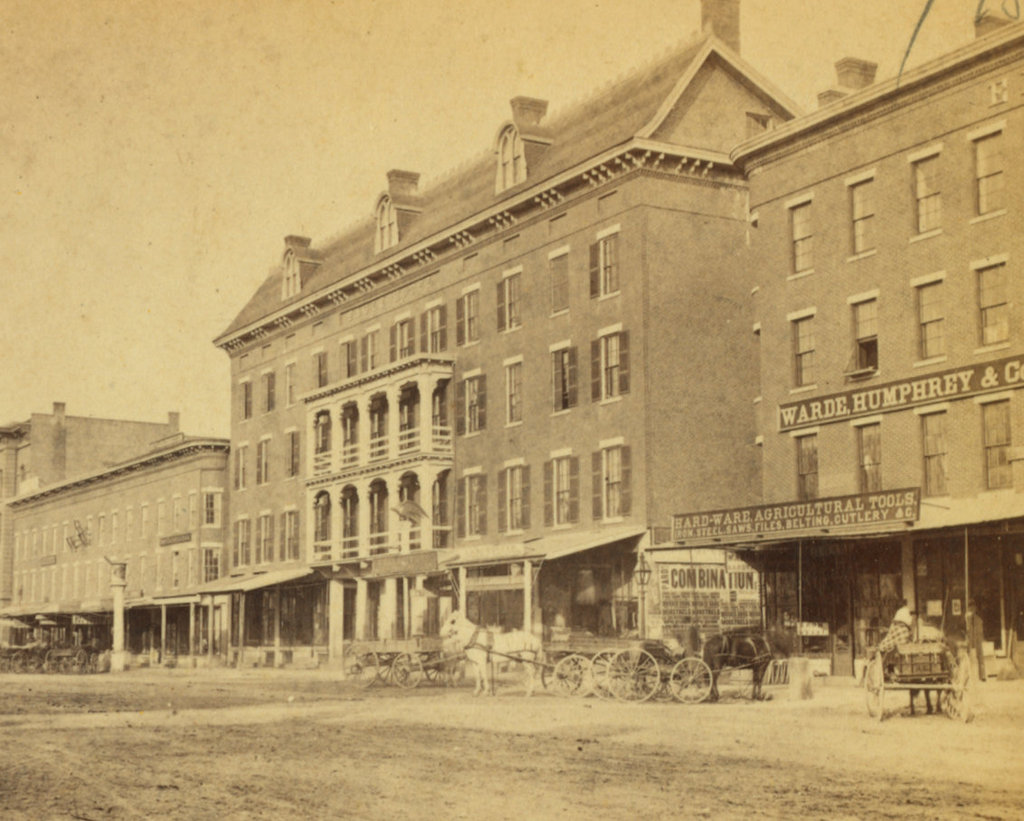
Looking north on North Main Street from the corner of Pleasant Street in Concord, New Hampshire, around 1874-1885. Image courtesy of the New York Public Library.
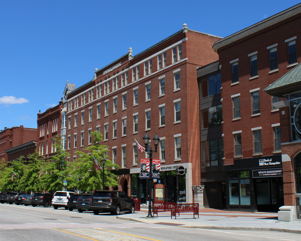
The scene in 2022:

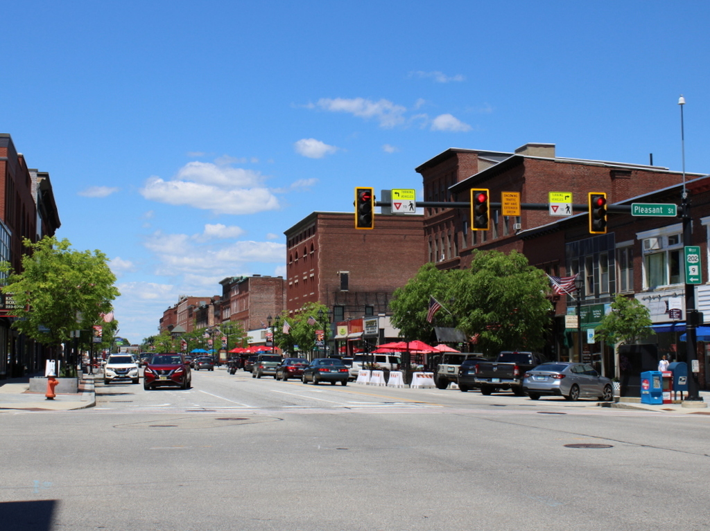
As these two photos show, much of downtown Concord has retained its historic architecture, with a number of buildings here that date back to the mid-19th century. Some have been altered over the years, but overall most of the buildings from the first photo are still standing here around 150 years later.

Starting in the foreground on the right side of the street is Moore’s Block at 4-12 North Main Street. This was built sometime around 1860, although over the years it has been altered almost beyond recognition. The main façade has been almost completely rebuilt, and today the only clue to its original appearance in this scene is the central window on the second floor, which is still topped by its granite lintel.

Beyond this building is the three-story Currier Block, which was also probably built in the 1860s, and the four-story Statesman Building, which was built around 1866-1867. The latter was originally the offices of the New Hampshire Statesman newspaper. Both buildings are still standing, and are still easily recognizable from their 19th century appearance.

On the far side of the Statesman Building is the corner of Depot Street, and then on the on the other side of the street was Bailey’s Block, which was built in 1874. Later known as Smith’s Block, it stood here until it was destroyed by a fire in 1960, and it was replaced by a one-story commercial building that now stands on the site.

Further in the distance in the first photo, with the tall windows on the upper floors, was Phenix Hall. This was an important city landmark in the second half of the 19th century, and its large auditorium served as a venue for many political gatherings, speeches, and other events. Perhaps the most notable visitor here was Abraham Lincoln, who delivered a speech here on March 1, 1860, several days after his famous Cooper Union speech in New York City. At the time, Lincoln was still a relatively obscure midwestern politician, but his speaking tour through the northeast helped to establish him as a major contender for the 1860 election.

The original Phenix Hall was destroyed by a fire in 1893, but true to its name it was soon rebuilt as the New Phenix Hall. Like its predecessor, it continued to be used as an event venue for many years, with prominent guests such as Theodore Roosevelt, who spoke here during his 1912 presidential campaign. The building was damaged by yet another fire in 1956, and was underutilized for many years during the second half of the 20th century. However, it is still standing, and is the subject of an ongoing restoration project.

On the other side of Phenix Hall, in the distant center of the first photo, is the three-story Phenix Hotel, which was built in 1857. It is difficult to tell now, but there are portions of this building that are still standing. As shown in the first photo, it originally had three stories and a flat roof, but it was later altered with the addition of a fourth story that was topped by a Mansard roof. This roof was eventually removed in 1947, and then seven years later all of the upper floors were removed, leaving only the one-story structure that stands today.

Further in the distance, the buildings become less discernable from this vantage point. However, there are a number of 19th century buildings that still stand today, including perhaps most notably the Eagle Hotel, which had been a favorite for New Hampshire politicians for many years.

Overall, the street itself could hardly be any different, with the horse-drawn carts on a rutted dirt road giving way to the cars that now pass through here on US Routes 3 and 202. However, most of the buildings from the first photo are still standing in some form or another, and the scene is still easily recognizable from the first photo. Because of this level of preservation, this section of North Main Street is now part of the Downtown Concord Historic District, which was added to the National Register of Historic Places in 2000.

Eagle Hotel, Concord, New Hampshire (2)

The Eagle Hotel on North Main Street in Concord, around the 1860s-1880s. Image courtesy of the New York Public Library.

The scene in 2022:

As explained in more detail in the previous post, the Eagle Hotel was the leading hotel in Concord during the 19th century. It opened in 1852 on the site of the earlier Eagle Coffee House, which had burned in 1851, and it remained in business for over a hundred years. Because of its location across the street from the State House, it played an important role in state politics. Many legislators stayed here when the General Court was in session, and politicians would often gather here for meetings.

Several presidents visited the hotel, including Concord resident Franklin Pierce, who lived in the hotel for several months between his election to the presidency and his inauguration in Washington. Presidents Rutherford B. Hayes and Benjamin Harrison also stopped at the hotel during visits to Concord, as did Richard Nixon on two occasions in 1954 and 1959, when he was serving as vice president.

The first photo was probably taken in either the 1860s or 1870s, and it shows the original exterior appearance of the hotel. However, the building underwent major changes in 1890. It included interior renovations, such as the installation of an elevator and a central heating plant, and it also included exterior work. The original gable roof was removed, and it was replaced by a fifth story with a flat roof. The porches on the front of the building were also removed at some point during the 19th century, although this apparently happened before the roof, because there are other photos that show the building with no porches but with the original roof.

The hotel ultimately closed in 1961, but it is still standing as one of a number of historic 19th century commercial buildings here on North Main Street. Other surviving buildings in this scene include Stickney’s Old Block at 120-132 North Main Street. This was built in 1851, replacing an earlier building that had been destroyed in the same fire as the Eagle Coffee House. A portion of the building closest to the Eagle Hotel was demolished in 1885 to build the existing New Hampshire Savings Bank building, but aside from this the remaining sections of the older building are still standing. On the other side of the Eagle Hotel is the Merchants Exchange Block, which was also built after the 1851 fire. As was the case with Stickney’s Old Block, a portion of it was later demolished, but the part visible in this scene is still here. All of these buildings, including the Eagle Hotel, are now part of the Downtown Concord Historic District, which was added to the National Register in 2000.

Fort Rodman, New Bedford, Massachusetts

Fort Rodman on Clark’s Point in New Bedford, around 1906. Photographed by Blanchard, Young & Co., courtesy of the Library of Congress.

The scene in 2022:

These two photos show the old stone fort at Ford Rodman, located on Clark’s Point at the entrance to New Bedford Harbor. Construction of the fort began in 1857, using granite from nearby Fall River and also from Sullivan, Maine, but it was still incomplete in 1861, at the outbreak of the Civil War. Concerned about the threat of marauding Confederate ships attacking the city’s whaling fleet, local officials took it upon themselves to build a small earthwork fort, which they named Fort Taber in honor of the current mayor. It was located directly to the west of the stone fort, in the distance on the left side of this scene. Fort Taber remained in use for about two years, until the stone fort was was completed enough to be usable.

As it turned out, the fort was never needed to fend off Confederate raiders, and the construction work was not completely finished before the end of the war. The work was halted, but then in the late 1800s the Army began to expand the facility by adding newer artillery batteries on the grounds near the stone fort, along with additional buildings. Although the stone fort did not officially have a name, it was often referred to as Fort Taber, since that name had been assigned to the earlier earthwork fort. However, in 1899 the entire facility was named Fort Rodman in honor of Lieutenant Colonel William Logan Rodman, the highest-ranking New Bedford native who was killed in the Civil War.

The first photo was taken soon after this, around 1906, and it shows the view of the fort from the south, facing toward the entrance to New Bedford Harbor. On the right side of the first photo is the old Clarks Point Light, a stone lighthouse tower that had been built more than a century later in 1804. It had been use until 1869, when a new lighthouse was constructed directly atop the walls of the fort. By the time the first photo was taken the lantern at the top of the tower had been removed, but the tower itself stood here until it was demolished in 1906, probably soon after the photo was taken.

Fort Rodman never saw any combat, but it remained in use as a coastal defense facility throughout World War I and World War II. It was later used as an Army Reserve site, before eventually being sold to the city of New Bedford in the 1970s. Many of the old fort buildings are gone now, and a wastewater treatment plant now occupies a portion of the grounds, but the original stone fort is still standing here. The area around it is now a public park, known as Fort Taber Park.

Old Third District Courthouse, New Bedford, Massachusetts

The building at the northeast corner of William and North Second Streets in New Bedford, around the 1870s. Image courtesy of the New Bedford Free Public Library.

The building in 2022:

This small brick and brownstone building was constructed in 1853, and it has seen a variety of uses over the years. It was originally built for the New Bedford Institution for Savings, as shown on the signage in the first photo, which was taken around 1870. The bank would remain here throughout most of the 19th century, before relocating to a different building in 1897. This building here on William Street was then converted into a courthouse, and it was used by the Third District Court of Bristol County.

As it turned out, its time as a courthouse would be relatively brief. The court left the building around 1914, and over the years it was occupied by a variety of commercial tenants, including an auto parts store by the second half of the 1900s. However, it was eventually reacquired by its original owner, the New Bedford Institution for Savings, and subsequently operated as a branch bank. The Institution for Savings would later be merged into Fleet Bank, and in 1995 Fleet donated the historic building to the Waterfront Historic Area League (WHALE), a preservation organization that was focused on revitalizing downtown New Bedford.

A few years later, WHALE in turn donated the building to the National Park Service, following the establishment of the New Bedford Whaling National Historical Park. It now serves as the park visitor center, and despite the many changes in use over the years the exterior has remained well preserved throughout all of this, as shown in these two photos. It is one of several buildings that comprise the National Historical Park, where they stand as important reminders of New Bedford’s heyday as a prosperous 19th century whaling port.