Corner of Doyers & Pell, Chinatown, New York City

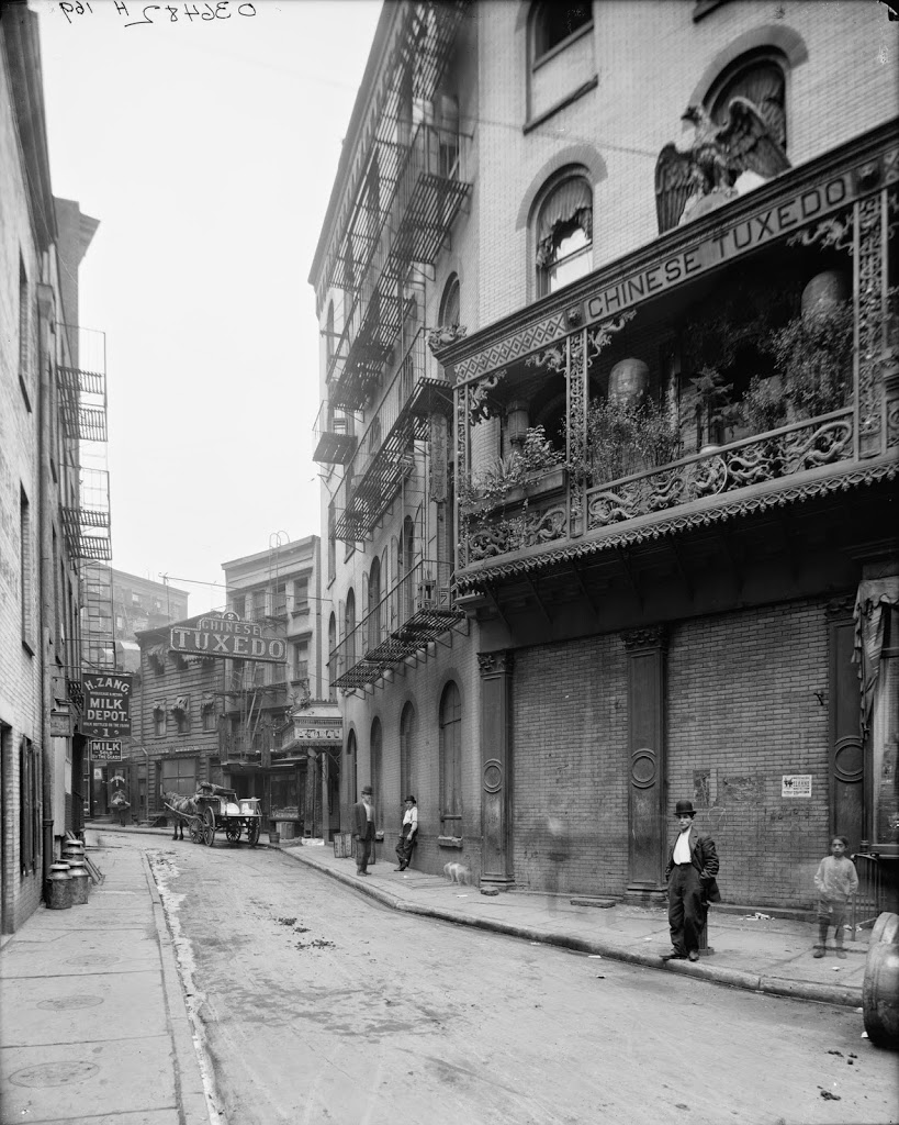
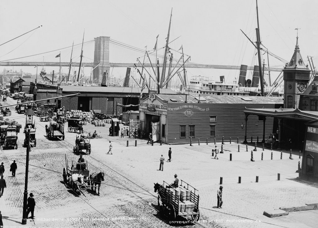
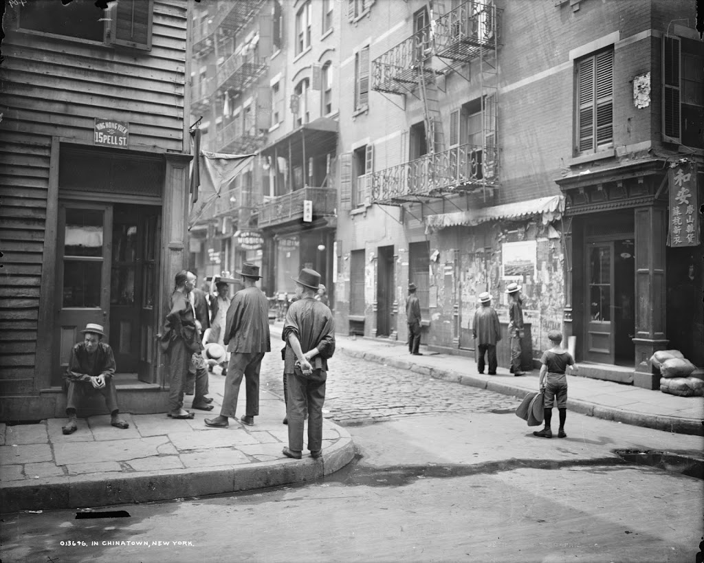
The view looking down Doyers Street from Pell Street, around 1900. Image courtesy of the Library of Congress, Detroit Publishing Company Collection.
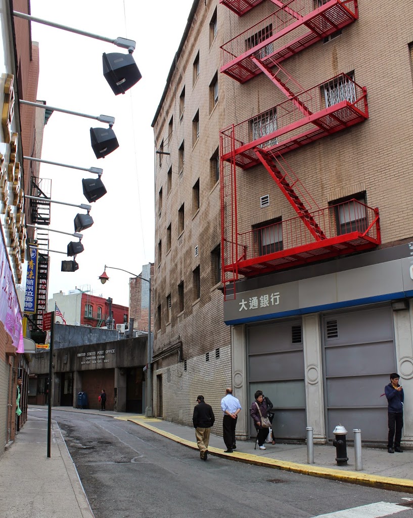
163_1900c-loc

The view in 2014:

163_2014

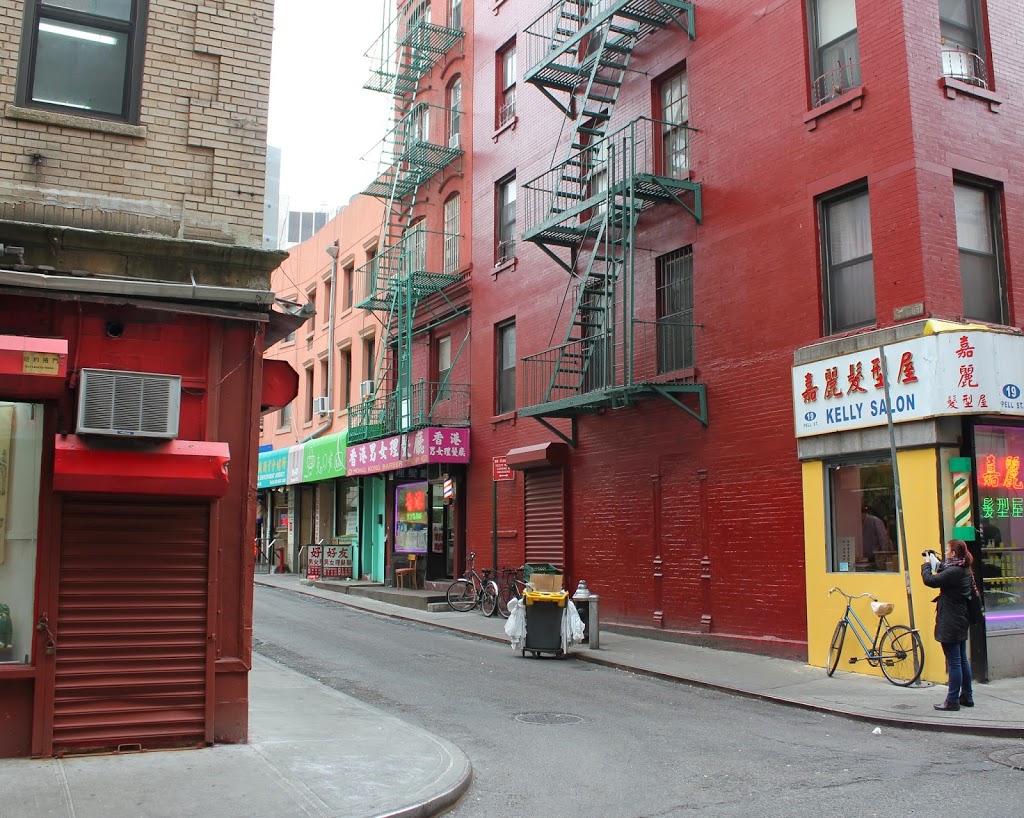
These photos show the other end of Doyers Street, 200 feet from this photo, along the narrow, winding street.  Over a century later, it is still at the heart of Chinatown, and even many of the buildings are still there, including the two on the right-hand side of the photo.  The building on the left of the 1900 photo, though, is gone, along with most other wood-frame buildings in Manhattan.

Doyers Street, Chinatown, New York City

The view looking up Doyers Street from Chatham Square, around 1900-1910. Image courtesy of the Library of Congress, Detroit Publishing Company Collection.

162_1900-1910-loc

The view in 2014:

162_2014

Doyers Street is a narrow, crooked street in the middle of Chinatown that, around the time that the first photo was taken, began to acquire the nickname of “the Bloody Angle” for the number of Chinese gang-related shootings that occurred throughout the first part of the 20th century.  The “Chinese Tuxedo” signs in the first photo are for a high-end Chinese restaurant that catered to American tastes.  Kind of like an early 20th century P.F. Chang’s, with some gang violence added into the atmosphere.

Grand Central Terminal, New York City

Grand Central Terminal, between when it opened in 1913 and around 1920. Image courtesy of the Library of Congress, Detroit Publishing Company Collection.

The same view in 2019:

Grand Central Terminal in New York City was built in 1913 on the site of a previous station, and although it is no longer the inter-city rail hub that it used to be, it is still a major part of rail transit in New York City, as seen in the 2019 nighttime photo of the concourse.  The concourse has undergone renovations and restorations along the way, which included building a staircase on the opposite end – using stone from the same quarry as the original structure – but it retains a very similar appearance, even down to the constellations on the ceiling, which can be seen in both photos.  The first photo is dated by the Library of Congress as being between 1910 and 1920, but it was likely taken around the time that it opened, to show the world for the first time what this station would look like.

South Street Docks, New York City

The view looking north along the South Street docks along the East River around 1900, with the Brooklyn Bridge in the background. Image courtesy of the Library of Congress, Detroit Publishing Company Collection.

175_1900c-loc.tif

The scene in 2014:

175_2014

There isn’t much left to remind visitors of the bustling seaport that lower Manhattan once was, and South Street itself, which was teeming with activity in 1900, is now a quiet street underneath the elevated FDR Drive (named after a person who, when the first photo was taken, was just starting his studies at Harvard).

The first photo shows the docks of the New York and Cuba Mail Steamship Company, also known as the Ward Line. They went out of business in 1954, and their docks are now home to the South Street Seaport, which owns a number of historic ships, including the Peking, the 1911 sailing ship visible in the second photo. The only actual structure from the 1900 photo that still exists today is the Brooklyn Bridge, seen in the background of both photos.

Wall Street Docks, New York City

The view of the docks at the foot of Wall Street along South Street in New York City, between 1900 and 1905. Image courtesy of the Library of Congress, Detroit Publishing Company Collection.

174_1900-1905-loc.tif

The same view in 2014:

174_2014

Located on the East River waterfront, across South Street from the foot of Wall Street, the ferry terminal at the left provided passage from Manhattan to Brooklyn. Although the importance of East River ferries decreased once the Brooklyn Bridge and subsequent bridges were completed, ferries still play a role in New York’s transportation, as seen in the 2014 photo, where the site is still being used as a ferry terminal.  The actual boats visible in the first photo are not the ferries; they belonged to the US Army Quartermaster Corps, which no longer has a base in this area.

Times Square

Times Square, as it appeared around 1905. Image courtesy of the Library of Congress, Detroit Publishing Company Collection.

130_1905c loc

The same view in 2014:

130_2014

The tall building toward the right-hand side of the 1905 photo is actually still there – it’s the Times Square Building, and was the headquarters of the New York Times in the early 20th century, hence the name “Times Square.” The New York Times hasn’t used the building in a century, but it’s still there, covered in billboards, and with the famous New Years ball at the top. Because of the building’s narrow dimensions, it’s actually more profitable to cover it in billboards and electronic signboards instead of renting it out.  Otherwise, all of the other buildings in the first picture are either gone or are completely hiding behind billboards and signs.  I think I like the 1905 photo better.