Burnside Bridge, Sharpsburg, Maryland

The view looking west toward the Burnside Bridge over Antietam Creek in Sharpsburg, Maryland, in September 1862. Photographed by Alexander Gardner. Image courtesy of the Library of Congress, Civil War Glass Negatives and Related Prints collection.

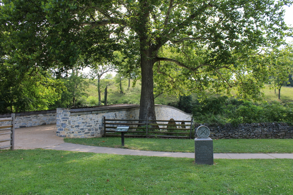
The scene in 2021:

The previous posts have featured some of the most distinctive landmarks on the Antietam battlefield, including the Dunker Church and the Bloody Lane. However, probably the single most iconic landmark at Antietam is this stone arch bridge, which came to be known as Burnside Bridge after the battle. In addition to photographs such as the first one here, the bridge has also featured prominently in numerous paintings of the battle, and even on the reverse of a commemorative coin issues by the U.S. Mint in 1937.

This bridge had been built in 1836 to connect Sharpsburg and the nearby town of Rohrersville. Prior to the battle it was generally known as the Lower Bridge, and it crossed Antietam Creek about a mile to the southeast of the center of Sharpsburg. It was constructed of local limestone, with three arches that spanned the creek.

This previously obscure rural bridge became famous for the events of September 17, 1862, when the Confederate Army of Northern Virginia under Robert E. Lee clashed with the Union Army of the Potomac under George B. McClellan. It was part of Lee’s first large-scale offensive campaign, when he invaded western Maryland as part of an effort to weaken northern morale. Upon reaching Sharpsburg, he set up a defensive position line near the town, and his right flank was positioned here in the vicinity of the Lower Bridge, on the high ground on the opposite side of the bridge in these photos.

Despite having a significantly larger army than Lee, McClellan believed that the opposite was true, and he exercised extreme caution in his attack. He did little to coordinate the movements of his different corps commanders, so it resulted in a piecemeal assault that negated the Union’s significant strength in numbers. The fighting began early in the morning, with an attack on the Confederate left flank near the Dunker Church. After this stalled, the battle shifted to a sunken road that became known as the Bloody Lane. There, after hours of fighting, the Union finally dislodged the Confederates from their makeshift trench, but the heavy losses had made the perpetually risk-averse McClellan unwilling to take the initiative and make an aggressive pursuit.

In the meantime, the southernmost part of the Union line was the IX Corps, under the command of General Ambrose Burnside. He was positioned a little to the east of the Lower Bridge, across the river from the right flank of the Confederates. This portion of the Confederate army was potentially vulnerable, with so many men fighting further north against the attacks on the left flank. However, Burnside did not receive orders from McClellan until around 10:00 a.m. Burnside then used a portion of his corps to find a river crossing downstream to outflank the Confederates, while also making several ineffective charges at the bridge itself.

Despite having a significant numerical advantage, with over 4,000 Union soldiers compared to just 500 Confederate defenders, the Confederates held off Burnside’s corps throughout the morning and into the early afternoon. In the process, the Confederates suffered about 120 casualties, while also inflicting about 500 Union casualties before Burnside finally took the bridge around 1:00 p.m. But, it would take another two hours for Burnside to move his men across the bridge and prepare for a final attack on the Confederate line.

The many delays throughout the battle, combined with McClellan’s ineffective coordination of his generals’ movements, prevented what could have otherwise been a decisive blow against Lee’s army. There were also many who questioned Burnside’s decision to waste time trying to take the bridge, rather than simply having his men wade across the relatively shallow creek. Ultimately, these delays meant that Burnside’s attack on the Confederate flank was countered by the arrival of A. P. Hill at 3:30 with fresh Confederate reinforcements. The final portion of the battle was fought between Hill and Burnside on the hill beyond the bridge, eventually drawing to an inconclusive end around 5:30 p.m.

That evening, Lee withdrew his army and made his way back to Virginia. In abandoning his invasion, it made the Battle of Antietam a strategic victory for the Union, although McClellan had missed the opportunity to make it one of the greatest Union triumphs of the war. He also failed to pursue Lee’s fleeing army, and this decision, combined with his ineffectiveness at Antietam, ultimately led President Lincoln to dismiss him as commander of the Army of the Potomac in early November. And, despite the questionable decisions that Ambrose Burnside had made here at this bridge, Lincoln picked him to replace McClellan. Burnside’s time as commander would prove to be short lived, though, because he was in turn dismissed after his own debacle at the Battle of Fredericksburg in December.

The first photo here in this post was taken only days after the battle. The photographer, Alexander Gardner, arrived at the battlefield on September 19, and he spent the next few days documenting the carnage here. He took a number of photographs of the bridge, which had survived the battle relatively unscathed despite being at the epicenter of intense fighting for several hours. In fact, at first glance the photo does not seem to give the immediate impression that a major battle had just been fought there.

However, on closer inspection, the photo offers clues about what happened here. On the bridge itself, many of the wooden boards are missing from the tops of the walls on either side of the walkway. While some of these may have been damaged in the battle, many of them were removed after the battle and repurposed as makeshift grave markers. In the foreground of the first photo, running along the stone wall to the right of the bridge, is a row of temporary graves, each of which is marked by a board from the bridge. These graves had likely been freshly dug shortly before the photo was taken, and many of the graves are topped by large mounds of dirt.

Following the battle, the bridge reverted to its original use, and this continued well into the 20th century and into the age of automobiles. It finally closed to vehicular traffic in 1966, when a bypass was constructed. More recently, the bridge underwent a major restoration after a portion of one of the walls collapsed into the creek. This project involved resetting the stones and repointing the masonry, and the work was completed in the spring of 2017.

Today, the bridge is part of the Antietam National Battlefield, which is run by the National Park Service. It is one of the best-preserved Civil War battlefields, and the quiet riverbanks here at the Burnside Bridge are a must-see for any visitors. The graves from the first photo have since been relocated, but otherwise this scene looks largely the same as in the first photo, aside from additions such as monuments to the regiments who fought here. Among these is a small monument in the foreground to the 51st Pennsylvania Volunteer Infantry, which was one of the units responsible for taking the bridge. However, perhaps the most remarkable feature in the present-day scene is the large sycamore tree that towers over the bridge in the center of the photo. This is the same tree that was growing next to the bridge during the battle, as shown in the first photo, and it stands as the most famous “witness tree” here on the Antietam battlefield.

Boston and Albany Railroad Arch Bridge, Becket, Mass

An early 20th century postcard showing the view looking east along the Boston and Albany Railroad, with a stone arch bridge on the left side and the Westfield River on the right. Image from author’s collection.
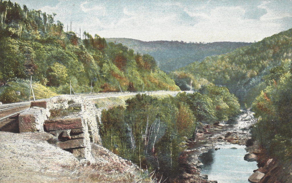
The scene in 2021:
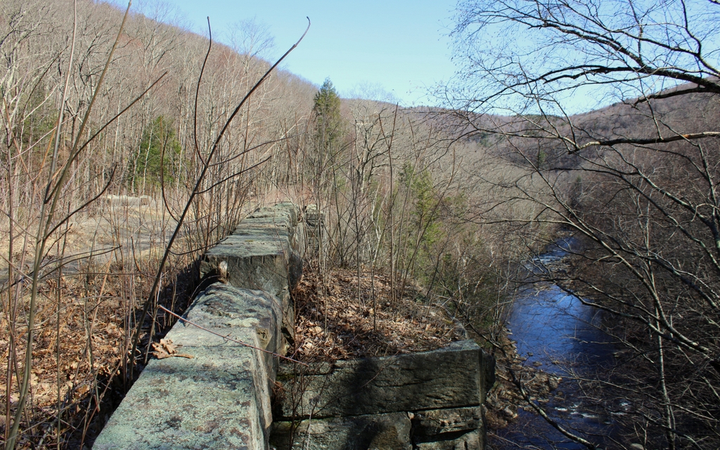
The first railroads in the United States were constructed starting in the late 1820s. These were mostly concentrated in the northeast, and they tended to be relatively short lines that linked neighboring cities. Here in New England, Boston soon emerged as an important railroad hub, and by the mid-1830s it had three different lines that radiated outward as far as Lowell, Providence, and Worcester. However, railroad investors had far more ambitious plans, including one proposal that would extended the line west of Worcester all the way to Albany.

Throughout the colonial era, and into the early 19th century, Boston had been one of the most important seaports in the present-day United States. However, as settlers moved west, and as the country acquired new territory, Boston found itself on the far eastern edge of a nation that was rapidly expanding westward. The opening of the Erie Canal in 1825 further threatened Boston by linking New York City with the Midwest, making it the primary seaport for trade with the inland regions.

As early as 1826, the Massachusetts state legislature had begun exploring the possibility of a railroad from Albany to Boston. This would prevent Boston from becoming economically isolated from the rest of the country, by providing an alternate route to the sea for goods transported along the Erie Canal. The state subsequently hired prominent civil engineer James F. Baldwin to examine potential routes through the state. The most promising was a southerly route, which would head west from Worcester through Springfield and Pittsfield before crossing into New York. This is, more or less, the route that would ultimately be opened a little over a decade later.

To achieve this goal, the Western Railroad was incorporated in 1833, although construction work did not start until 1837. The eastern half of the railroad, from Worcester to Springfield, was relatively easy to build, and it opened on October 1, 1839. However, the western portion, which crossed the mountains of the Berkshires, was a far more challenging engineering feat. By this point, railroad technology was still in its infancy, and there were still significant questions about the ability of steam locomotives to operate on steep grades. Some doubted whether a locomotive could handle grades greater than one percent (one foot of vertical rise for every hundred feet of track), and many early railroads used steam-powered inclined planes to pull trains up steep sections of the route. However, any crossing of the Berkshires would require consistent grades in excess of one percent, in some places even exceeding 1.5 percent.

To reach the divide between the Connecticut River and Housatonic River watersheds, the route of the railroad followed the Westfield River to the west of Springfield. In the town of Huntington, the river splits into three main branches, with the railroad continuing upstream along the west branch. From there, the river valley becomes increasingly narrow and winding, particularly in the last 13 miles from Chester to the watershed divide in Washington.

In order to oversee this project, the railroad hired George Washington Whistler as chief engineer. An 1819 graduate of West Point, Whistler was one of the nation’s leading civil engineers, and he was involved in the construction of many early railroads. He would go on to earn international fame from his accomplishments here on the Western Railroad, and Czar Nicholas I of Russia subsequently hired him to build the Saint Petersburg–Moscow Railway. However, Whistler’s fame would ultimately be eclipsed by his son, the prominent artist James Abbott McNeill Whistler, who was a young child living with his family in Springfield when George Washington Whistler built the Western Railroad.

For Whistler, the most difficult part of the project would be the 13 miles between Chester and Washington, where the railroad rose in elevation from 600 feet in Chester to 1,459 feet at the watershed divide. This was a serious challenge, given the concerns about the technical limitations of steam locomotives, but Whistler also had to build this railroad within the confines of a narrow, sinuous river gorge. This meant the railroad would require a series of deep rock cuts and high embankments, along with repeated crossings of the river, in order to maintain a reasonable grade. Even so, the finished railroad would have a six-mile section with an average grade of 1.51 percent, and a maximum grade of 1.57 percent.

Probably the most distinctive feature of this section of the railroad is its many bridges. The railroad crossed the river a total of 21 times in these 13 miles, and ten of these bridges were masonry arch bridges, including the one shown here in these two photos. The original intent had been to use simpler bridges with rubble masonry abutments, but these would have been vulnerable to spring flooding, so the railroad opted for more substantial arch bridges. This required excavating down to bedrock to anchor the abutments, and it also meant bringing in quarried stone from elsewhere, since the local stone proved to be of inferior quality. This was a significant expense for the railroad, as these quarried blocks—which weighed upwards of a thousand pounds each—had to be transported along rough roads to these remote work sites along the river.

Aside from the bridges, other labor-intensive work included the many cuts and fills along the railroad bed. A little to the east of the bridge in this photo, just beyond the curve in the distance, is a deep rock cut, measuring about 575 feet long and 30 to 40 feet deep. In the days before dynamite and other high explosives, this work would have been done using only black powder and hand tools such as picks and shovels. Beyond this rock cut was an embankment, with a long stone retaining wall that had to be built to keep the railroad bed from sliding off the steep cliff down to the river. A few miles to the west of the stone bridges, at the highest point of the railroad in the town of Washington, was an even larger rock cut. It was about a half mile long, and 55 feet deep at its deepest point.

All of this work, including the unanticipated need for stone arch bridges, led to significant cost overruns for the Western Railroad. In 1838, prior to the start of construction, the cost of building section of the railroad to the west of the Connecticut River was estimated at $2.1 million. The actual cost turned out to be a little over $2.5 million, including nearly $1 million just to build a 13-mile section here in the Berkshires. The single most expensive mile was just a little to the east of the scene in these photos, between mile markers 127 and 128. Within that mile, the railroad crossed the river three times on large stone arch bridges, and cost nearly $220,000. The company’s January 1841 annual report explained some of the reasons for these added expenses, quoting the engineer (presumably Whistler), who wrote about the challenges of building the railroad through this section along the Westfield River:

With the limited knowledge of the character of the stream here, at the time of the original estimate, and, judging of its effects in times of freshets, from the comparatively unstable character of the structures then existing on the turnpike, occupying almost the immediate line of the rail-road, in tolerable security, it was then judged that structures of the more ordinary kind, with common rubble masonry for bridge abutments and side walls, would give ample security to the road, and such was estimated for. But the experience in time of our personal knowledge of the effects of freshets in this stream, proved the necessity of abandoning such structures, and resorting to others of a more costly and permanent character. Stone arches of large openings were adopted, requiring masonry of a very different and superior character to support them;—rendering it necessary too to resort to great depths in search of permanent rock foundations below the bed of the stream. This was the more readily acceded to at the time, from the belief (as every appearance indicated) that materials suitable for such structures would be obtained from the rock cuts in their immediate vicinity. But soon after they were commenced, and the character of the stone exposed by the opening of the cuts, it proved entirely unfit; and the contractor was compelled to resort to quarrying and hauling the stone from a distance, and over roads almost impassible;—thus rendering it necessary to increase his prices to meet this additional cost.

The work of actually building the railroad was largely done by immigrant laborers, primarily the Irish. At one point there were several thousand workers employed here, and this is evident in the 1840 census, which was conducted in the midst of the railroad construction. In a sort of precursor to the later railroad boom towns that would follow the First Transcontinental Railroad several decades later, the town of Middlefield—located on the north side of the river—saw a particularly dramatic increase in population. From a population of 720 in 1830, Middlefield grew to 1,717 in 1840, with the census noting that 686 were from “Middlefield proper,” while the rest were counted as “extraneous population.”

These workers generally lived in temporary shantytowns along the river, and the census indicates that most were in their 20s or 30s, with few over the age of 40. The 1840 census does not provide much specific demographic information, and only the heads of the households are individually named, but the census data suggests that most of these men lived here with their families. Most of the households included both a man and a woman who were between the ages of 20 and 40, along with several young children who were generally under the age of 10. The surnames of the heads of household were overwhelmingly Irish, with Murphy being a particularly common name among the workers in Middlefield.

The arrival of so many foreign immigrants in a small, rural community was not without controversy. Early in the construction process, in the spring of 1839, the Hampshire Gazette published an article titled, “The Irish on our Public Works,” which addressed concerns about the societal impact of the Irish immigrants who were working on the railroad. The article warned that, “[i]f some measures are not taken for the education and moral reformation of the multitudes of Irish and other foreign emigrants that swarm the country, our republic will be much in danger from them.” Perhaps in response to these concerns, a few months later a resident of Middlefield began raising funds to establish three schools for the children of the laborers. It seems unclear as to whether these contributions were motivated by genuine altruism or by nativist fears about an under-educated immigrant class, but a subsequent article in the Boston Evening Transcript declared that the students were “learning rapidly, and doing credit to the labors of their benefactors.”

These workers remained here throughout the summer of 1841, and the railroad was ultimately completed in the early fall, with the final tracks laid at the rock cut in Washington on October 2, 1841. The railroad opened two days later, linking Boston and Albany. In the process, the railroad set a number of records. It was, up to that point, the longest and most expensive railroad in America, and it was also the first to be built through mountains without using steam-powered inclined planes to assist locomotives. As such, it was a significant engineering milestone, and it was enough to gain the attention of the czar, who brought Whistler to Russia as soon as his work here on the Western Railroad was finished.

However, despite the completion of the railroad, there would continue to be challenges, including a fatal accident that occurred on October 5, 1841, just a day after the line opened. The railroad originally just had one track, with occasional passing sidings for trains heading in opposite directions, including ones at Chester and Westfield. On this particular day, both the eastbound and westbound trains were given instructions to meet at Chester before proceeding. However, the eastbound conductor apparently never received this message, and was expecting to meet the other train further down the line in Westfield. This resulted in a head-on collision about four miles west of Westfield, killing the conductor of the eastbound train and one passenger, along with injuring many others. The accident was a personal tragedy for George Washington Whistler, whose niece, Caroline Bloodgood, was on the train. She was among those injured, and her young son was the one passenger who was killed in the accident.

The Western Railroad did manage to help dispel the myth that steam locomotives were unable to ascend steep grades under their own power, but the section of the railroad here in the Berkshires was nonetheless challenging for trains. Whistler had selected locomotives that were built by Ross Winans of Baltimore, a friend of his whose daughter Julia would later marry his son George. Nicknamed “crabs,” presumably because of their eight drive wheels and Maryland origins, these locomotives proved unreliable here on the Western Railroad, and the railroad ultimately resorted to custom building their own mountain locomotives at their shops in Springfield.

Despite these setbacks, the railroad overall proved to be a success, and for many years it was the only east-west railroad through the Berkshires, providing an important transportation link between Boston and the rest of the country. Although it was originally built as a single-track railroad, Whistler had wisely designed the bridges and other structures to accommodate a second track. This made the initial construction costs higher, but in the long run it saved the railroad money by making it easy to add a second track without having to reconstruct all of the bridges.

For travelers along the route, this section through the Berkshires was a highlight of their journey. The 1847 travel guide A Chart and Description of the Boston and Worcester and Western Railroads, published only six years after the railroad opened, provides the following description:

No language that we are master of could give the traveller any proper description of the wildness, the grandeur, or the obstacles surmounted in the construction of this portion of the route. The river is exceedingly crooked, and the lofty mountains, which are very steep and rugged, and of solid rock, shut down quite to the river on both sides, their sharp points shooting by each other, rendering crossings at every bend of the stream indispensable. In addition to this, the points of the hills must be cut away, and for many miles these rock cuttings and bridges follow each other in regular and rapid succession. . . . Nor does the passing traveller, hurling along as rapidly as he is, see much of the beauty of this mountain gorge. It is not until he has seen, from the base of these mighty structures of art, the passage of the cars, that their magnificence is really felt.

The Western Railroad would ultimately merge with the Boston and Worcester in 1867, forming the Boston and Albany Railroad. This company would, in turn, be leased by the New York Central starting in 1900, although this line retained the Boston and Albany name well into the 20th century. In the meantime, the railroad continued to make improvements to the route, including some changes here along the banks of the Westfield River. A few of the original bridges were replaced, including the easternmost one, which was replaced in 1866 with the current double arch bridge. The next bridge upstream from there was replaced in 1912 with the current steel deck truss girder bridge, although the original stone abutments appear to still be there, encased in poured concrete. Much further upstream, the westernmost two bridges were apparently reconstructed in 1928 after having been damaged in a flood, although it is possible that portions of the original bridges are still underneath the concrete.

However, the most significant change to this portion of the railroad occurred in 1912, when about a mile of the railroad was rerouted, including the section shown here in these two photos. The first photo was probably taken only a few years before this occurred. The postcard is undated, and does not have a postmark, but it has an undivided back, suggesting that it was printed before 1907. As part of this realignment, the railroad shifted to the south side of the river, eliminating two of the river crossings. One of the original bridges, located about 300 yards west of here, was demolished as part of this project, in order to make room for a new bridge. Three other original bridges were simply abandoned, including this one here, which is the westernmost of the three.

Today, more than a century after the railroad was rerouted, these three bridges are still standing. One of them, the easternmost, is still on land owned by the railroad, and it is directly adjacent to the active rail line, so it is not accessible to the public. However, the other two bridges, along with the 3,000-foot section of abandoned railroad right-of-way between them, are now owned by the state as part of the Walnut Hill Wildlife Management Area. The bridges are accessible by way of the Keystone Arch Bridge Trail, a 2.5-mile long trail that starts in Chester. Despite being over 180 years old, and despite not having been maintained in well over 100 years, these bridges remain in good condition, clearly fulfilling Whistler’s goal of creating bridges of “a more costly and permanent character.”

As the travel guide had indicated back in 1847, it is hard to get a sense of the scale of these bridges from the railroad. Even today, it is hard for visitors to tell just how big these bridges are while standing atop them, and photographs are likewise unable to capture the full scope of these structures. Only by climbing down to the river and looking up at the arches can a visitor fully appreciate the size of the bridges, and the work that went in to building them in the middle of a river gorge in one of the most remote areas of the state.

Of the three surviving bridges, the one here in this scene is the largest. Including the wingwalls, the structure of the bridge is over 500 feet long, the bridge deck is about 25 feet wide, and the top of the bridge rises about 75 feet above the river. The bottom of the arch is about 60 feet above the water, and the total span of the arch is 54 feet. The bridge is mostly in its original condition, although about three-quarters of the parapet stones are gone, having apparently been pushed over the edge by vandals over the years.

In 1980, this bridge was added to the National Register of Historic Places as a contributing structure in the Middlefield–Becket Stone Arch Railroad Bridge District. Then, in 2021, the two surviving stone arch bridges on public property, including this one, were designated as National Historic Landmarks as part of the Western Railroad Stone Arch Bridges and Chester Factory Village Depot district. The district is also comprised of the railroad bed in between the two bridges, including the large rock cut and stone retaining wall, along with the historic railroad station in the center of Chester, several miles to the east of here. This station is owned by the Chester Railway Station and Museum, which features an extensive collection of artifacts relating to the Western Railroad and the construction of these bridges.

For more information on the history of these bridges, the National Historic Landmark Nomination Form is an excellent resource. The Friends of the Keystone Arches also has an excellent website, with plenty of historical information and photographs, along with information about hiking to the bridges.

Mount Tom Railroad, Holyoke, Mass (3)

The trolley Elizur Holyoke approaching the summit on the Mount Tom Railroad, around 1905-1915. Image courtesy of the Library of Congress, Detroit Publishing Company Collection.

The scene in 2021:

The first photo shows the trolley Elizur Holyoke, one of two that operated on the Mount Tom Railroad. Together with the Rowland Thomas, these two cars formed a funicular railway; they were connected by a cable that allowed the descending car to use its weight to help pull the other one up the mountain. This cable, which is seen in the foreground in the middle of the tracks in the first photo, was not powered by a motor at the summit, but instead each car had its own motors, which drew power from overhead wires by way of a trolley pole, as shown atop the Elizur Holyoke in the photo.

The Mount Tom Railroad opened in 1897, allowing visitors to reach the newly-constructed Summit House atop the 1,200-foot Mount Tom. It was just under a mile in length, and it rose 700 feet in elevation, with an average grade of 14 percent and a maximum of 21.5 percent. Most of the route was straight, with the exception of a curve near the summit, which is shown here in this scene. The cars typically ran once every half hour, although they could be operated more frequently depending on demand. Each car could seat 84 passengers, and over the course of an average season the railroad typically carried about 75,000 people to and from the summit.

Aside from the railroad itself, this scene also offers a view of the northernmost portion of the Mount Tom Range, along with part of the Holyoke Range. Appropriately enough, the first photo shows the Elizur Holyoke directly below Mount Holyoke. Both the mountain and the trolley share the same namesake, and the mountain also lent its name to the city of Holyoke, where Mount Tom is located. Further to the left of Mount Holyoke is Mount Nonotuck, which is visible near the upper left corner of the first photo.

When the railroad and Summit House here on Mount Tom opened in 1897, both of these mountains already had long-established hotels at their summits, with the Prospect House on Mount Holyoke and the Eyrie House on Mount Nonotuck. Unlike those businesses, though, the Summit House did not offer overnight accommodations, and instead catered entirely to day visitors. In any case, the aging Eyrie House was never a major competitor to the Summit House, and it ultimately burned in 1901. As for the Prospect House, its 20th century history would largely mirror that of the Summit House, and both ultimately closed in the late 1930s amid declining business during the Great Depression.

The Summit House was demolished around 1938, and the railroad tracks were removed around the same time. Then, in 1944 the property was sold to the radio station WHYN, which built towers and buildings at the summit and converted the railroad right-of-way into a paved access road. Overall, though, this scene has not changed much, aside from the loss of the railroad tracks. The slopes of Mount Tom still look much the same as they did when the first photo was taken, as do the mountains in the distance, although some are obscured by tree growth in the present-day photo. Even the Prospect House on Mount Holyoke is still standing, and it is barely visible as a tiny white speck just to the left of the summit in both photos. Now preserved as a museum, this historic building is one of the few surviving 19th century mountaintop resorts in the northeast, having long outlived its newer competitors on Mount Nonotuck and here on Mount Tom.

Mount Tom Railroad, Holyoke, Mass (2)

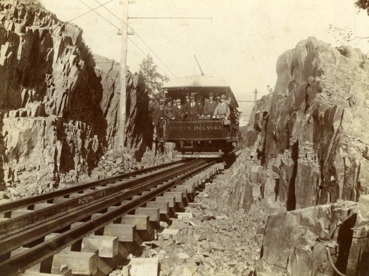
The trolley Elizur Holyoke passing through a rock cut on the Mount Tom Railroad, around 1900-1910. Image courtesy of the Holyoke Public Library.

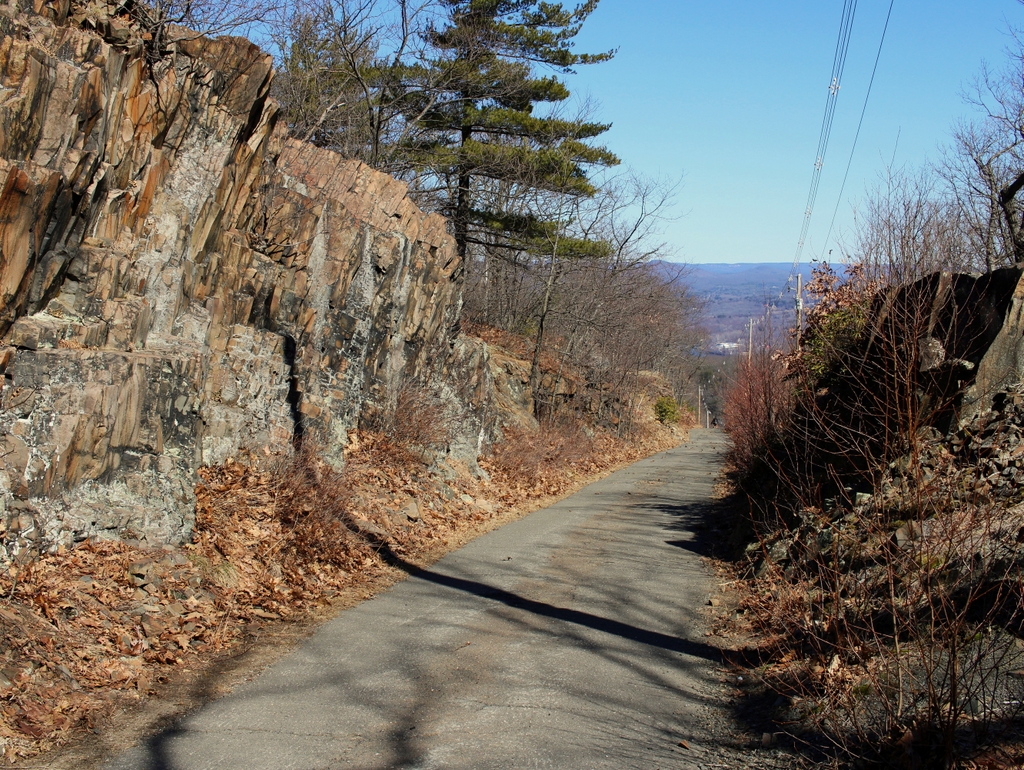
The scene in 2021:

As explained in the previous post, the Mount Tom Railroad was a nearly mile-long funicular railway that brought visitors up to the Summit House at the top of Mount Tom. It opened in 1897, and it featured two trolleys connected by a cable. When one car descended, its weight helped pull the other car up the mountain. Each car also had its own electric motors, powered by overhead wires, which provided additional power to compensate for differences in weight and energy lost to friction. Most of the rail line what a single track, aside from a short turnout at the midpoint to allow the cars to pass.

The railroad rose 700 feet in elevation, with an average grade of 14 percent and a maximum grade of 21.5 percent. The route was mostly straight, although there was a gentle curve near the summit. Along the way, this route required several rock cuts and fills, to maintain a consistent grade. The largest of these cuts is shown here in these photos, about a third of a mile below the summit station. Here, trolleys would pass between two walls of Mount Tom’s distinctive basalt traprock, with its step-like formation.

The first photo shows the trolley Elizur Holyoke, named for the early settler who became the namesake of Mount Holyoke. According to tradition, he and fellow pioneer Rowland Thomas led an expedition up the Connecticut River, with Holyoke traveling up the east side and Thomas on the west side. After reaching an area where the river passes between two mountain ranges, the two men decided to name the eastern one for Holyoke, and the western one for Thomas. Appropriately enough, the other trolley here on the railroad was named the Rowland Thomas.

The Mount Tom Railroad remained in service for about 40 years. Its operating season generally lasted from May through October, and in a typical year would average around 75,000 visitors during the season. Among the most famous of these was President William McKinley, who visited with his wife Ida in 1899 and rode up the mountain on the Elizur Holyoke. Calvin Coolidge and his future wife Grace Goodhue also rode up the railroad in the early 20th century, although with far less fanfare than McKinley had enjoyed, since Coolidge was still an obscure young Northampton lawyer at the time.

The Summit House suffered two disastrous fires, first in 1901 and again in 1929. The second was particularly devastating to the railroad, since its small, hastily-constructed replacement failed to draw the same number of visitors to the summit. This, combined with increased car ownership during the 1920s and the Great Depression of the 1930s, ultimately led to the Summit House and the railroad closing by the late 1930s. In 1938 the Summit House was dismantled, and around the same time the railroad tracks were torn up and removed.

During its many years in operation, the Mount Tom Railroad had a good safety record, and it does not appear to have had any major incidents. However, less than a decade after the railroad closed, this spot here would become the site of a deadly transportation disaster. On the night of July 9, 1946, an Army Air Corps B-17 airplane was en route from Goose Bay, Labrador to Westover Field in Chicopee. The plane had a crew of four, and it also carried 21 passengers who were returning from active duty in Greenland, including 15 Coast Guardsmen, four Army Air Corps servicemen, and two civilians. While attempting to land at the nearby airfield in the dark on a rainy night, the plane instead crashed into Mount Tom, hitting the exposed rock along this section of the railroad grade. The impact disintegrated the plane, killing all 25 men instantly and starting a large fire here. A group of people at nearby Mountain Park climbed up the railroad right-of-way, but they could not get close to the crash scene because of the intense heat, and in any case there was little that they could have done to assist at that point.

Today, more than 80 years after the railroad closed, its route is now a paved access road for the telecommunications towers that occupy the former site of the Summit House. However, there are still remnants of the old railroad along the road, including piles of discarded ties and metal support braces for the utility poles. On a more somber note, however, there are also many remnants of the B-17 crash throughout this area, including pieces of twisted metal and fragments of melted aluminum. The site of the crash is now marked by a monument that is inscribed with the names of the 25 men who died here. It is located about 100 yards in the distance, atop a rocky outcropping on the left side of the road. The monument itself is not visible in the present-day photo, but it can be reached via a short path that starts at the green bush in the distant center of the photo.

Mount Tom Railroad, Holyoke, Mass

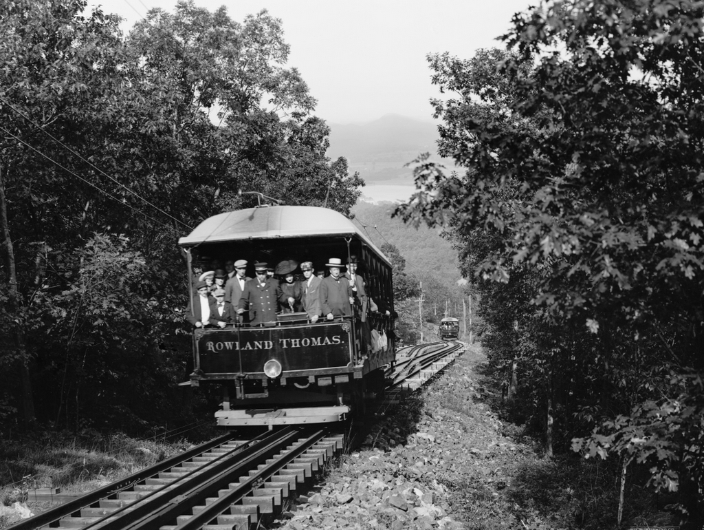
The trolley Rowland Thomas on the Mount Tom Railroad in Holyoke, around 1905-1915. Image courtesy of the Library of Congress, Detroit Publishing Company Collection.

The scene in 2021:

The early 20th century was the heyday of electric trolleys in the United States. In the years prior to widespread car ownership, most cities and even many small towns were served by networks of trolley lines that were generally run by private companies. In order to maximize profits, these companies often built picnic groves, amusement parks, and other recreational facilities along their lines. Known as trolley parks, these generated revenue not only through admission fees, but also through increased trolley ridership on otherwise-slow weekends.

Here in Holyoke, the Holyoke Street Railway Company opened Mountain Park in the 1890s. It began as a small park at the base of Mount Tom, but it soon added amenities such as a dance hall, a restaurant, a roller coaster, and a carousel. Most significantly, though, the company also built a summit house at the top of the 1,200-foot mountain, allowing visitors to enjoy the expansive views of the Connecticut River valley. Mountaintop resorts were popular in the northeast during the late 19th and early 20th centuries, and there were already several in the vicinity of Mount Tom, including the Prospect House on Mount Holyoke and the Eyrie House on Mount Nonotuck. However, unlike those establishments, the Summit House here on Mount Tom was not a hotel. Instead, it catered to day visitors, with a restaurant, a stage, and an observatory equipped with telescopes.

To bring visitors to the Summit House, the company constructed the Mount Tom Railroad, a nearly mile-long funicular railway that rose 700 feet in elevation from Mountain Park to a station just below the summit. It had an average grade of 14 percent, with a maximum grade of 21.5 percent at its steepest section. The lower part of the route was straight, as shown here in this view looking down from the midpoint, although there was a gentle curve right before the summit station. Like most funiculars, it consisted of two cars that were connected by a cable. As one car descended, it pulled the other car up the mountain, allowing gravity to do most of the work. The cable itself was unpowered, but the cars each had their own electric motors powered by overhead wires, in order to compensate for weight differences and energy lost to friction.

The two cars were named the Rowland Thomas and Elizur Holyoke, in honor of the early colonists who became the namesakes of Mount Tom and Mount Holyoke. Each car was 36 feet long, 9 feet wide, and could seat 84 passengers. They were connected to each other by a 5,050-foot-long, 1.25-inch steel cable, which passed over a large sheave at the summit. This sheave was mounted on an A-frame that was, in turn, bolted securely into the rock. In addition, the cars maintained constant telephone connection with each other, by way of telephone lines that ran alongside the tracks just above ground level, as shown in the lower left corner of the first photo. The cars connected to these by way of brush-like shoes that ran along the top of the wires as the car moved.

Because of the steep grade of the railroad, the cars’ braking ability was of critical importance, as an uncontrolled descent would likely have had deadly consequences. To prevent this, the cars had several independent braking systems. Each car was equipped with standard trolley brakes, but the cable itself was controlled by a centrifugal governor at the summit that automatically slowed the cable once it began moving faster than 1,400 feet per minute, or about 16 miles per hour. This second feature obviously only worked if the cable remained intact, but there was yet another braking system in the event of a catastrophic failure of the cable. As shown in the first photo, a third rail ran inside the tracks next to the cable. In an emergency, the motorman could activate a lever that would cause the car to clamp on to this rail. This could also be done automatically, by a governor that was set to engage the rail once the car exceeded 1,500 feet per minute, or 17 miles per hour.

In any funicular railway, one of the other challenges is determining how the two cars will pass each other. The simplest solution is to have two parallel tracks, with each car operating on its own track at all times. However, this requires a wider right-of-way, along with significantly more materials than a single-track railway. One alternative is a three-rail funicular, in which each car has its own outside rail and shares the middle one, diverging only at a short passing section. The other option is to have one track for both cars, with a turnout at the halfway point. This requires the least amount of land and materials, but it requires a complex track arrangement at the turnout to ensure each car takes the correct path and safely crosses over the cable.

Here on Mount Tom, the railroad engineers chose the third option, as shown in the first photo. The two cars met at a passing loop, which is visible in the lower center of the photo. At first glance it looks similar to a standard railroad switch, but the key difference is that it has no moving parts. Instead, the cars and tracks are designed so that each one can only take one path, which remains the same regardless of whether the car is heading up or down the mountain. As such, the Rowland Thomas always took the tracks on the north side (the left side when viewed from this direction), while the Elizur Holyoke always took the south side.

To achieve this, the two cars had different wheel arrangements. The wheels on one side of the car had a wider tread than on the other side, which caused them to be guided along deflector rails onto the correct track. For the Rowland Thomas, these wide-tread wheels were on the left side when it was headed uphill, and for the Elizur Holyoke they were on the right side. On the same side as these wheels, each car also had an extra set of wheels that were slightly raised above the others and hung out about 15 inches from the main wheels. Because the turnout required gaps in the main rail to allow the cable to pass through, there was a short section of rail next to these gaps. As the main wheels approached the gap, the auxiliary wheels would roll along this additional rail, preventing what would otherwise be a derailment.

Work on the railroad began in March 1897, and it was completed in time for the summer season, opening on May 25. It operated throughout the summer and into the fall foliage season, before closing for the winter at the end of October. Round trip fare was 25 cents, and included the trolley ride along with use of the Summit House. The trolleys were scheduled to run twice an hour, with extra trips as needed. However, by September this schedule was insufficient to keep up with demand, as indicated by a Springfield Republican article that criticized the railroad for dangerously overcrowded trolleys.

During the early years of the railroad, perhaps its most distinguished passenger was President William McKinley, who visited Mount Tom along with his wife Ida on June 19, 1899. A number of onlookers gathered at the lower station to catch a glimpse of the president, who sat in the front seat of the Elizur Holyoke trolley for the ride up the mountain. At the summit, he and Ida were likewise greeted by a large crowd, and they spent about an hour there, where they ate a light lunch at Summit House before heading back down the mountain.

As it turned out, the McKinleys would be the first of at least two presidential couples who would travel up the Mount Tom Railroad. About five years later, a young Calvin Coolidge and Grace Goodhue visited the mountain on a date. At the time, Calvin was a lawyer in Northampton and Grace was a teacher at the Clarke School for the Deaf. While at the Summit House, he purchased a souvenir plaque of the mountain, which became the first gift he ever gave her. They subsequently married in 1905, and he went on to become governor, vice president, and then ultimately president in 1923.

In the meantime, the original Summit House only lasted for a few years before being destroyed by a fire in 1900. Its replacement opened the following year, but this too would eventually burn, in 1929. By contrast, the Mount Tom Railroad itself appears to have avoided any major incidents throughout its history. However, there were occasional breakdowns that forced passengers to walk down the mountain, and in at least one instance causing a number of people to spend the night in makeshift accommodations at the Summit House.

On July 24, 1928, at around 9:15pm, the Rowland Thomas had to stop about 150 feet from the upper station because of a broken journal on one of its axles. This likewise caused the Elizur Holyoke to stop the same distance from the lower station. The passengers on the Elizur Holyoke were able to easily return to the station, but about 50 people were  stranded at the summit. Many chose to walk down the mountain in the dark, guided by railroad employees with lanterns, but 22 remained at the Summit House overnight. Some stayed up all night, playing bridge and dancing, and most descended the mountain after sunrise, although four guests stayed at the summit until railroad service was restored later in the day. A similar incident occurred less than a month later, when a spread rail stopped the trolleys at about 9:00pm. This time, 35 people walked down in the dark, but it does not appear that anyone spent the night at the summit.

After the 1929 fire at the Summit House, the railroad quickly constructed a temporary replacement at the summit. It had intended to then build a more permanent structure, but by the early 1930s the mountain faced declining numbers of visitors. Part of this was because of the Great Depression, which began just months after the fire here. Another factor was increased car ownership among the middle class, which meant that recreational activities were no longer limited to places that people could access by trolley.

At the base of the mountain, Mountain Park would remain a popular amusement park for decades, but both the Mount Tom Railroad and the Summit House closed in the late 1930s. The temporary Summit House was dismantled for scrap metal in 1938, and around the same time the railroad tracks were taken up and removed. The rails and other metal components were presumably reused or scrapped, but the wooden ties were discarded in piles alongside the right-of-way. More than 80 years later, many of these ties are still in remarkably good condition, and a few are visible in the lower right corner of the second photo.

The railroad ultimately sold the summit area and the right-of-way to the WHYN radio station, which constructed radio towers and transmitter buildings on the site of the old Summit House. The old railroad grade was paved over, and it became an access road for the radio station. As a result, the present-day scene looks very different from the first photo, although there are still a few remnants of the old railroad, including the ties, some discarded spikes, and metal support braces for the old utility poles that once supported the electrified trolley wire.

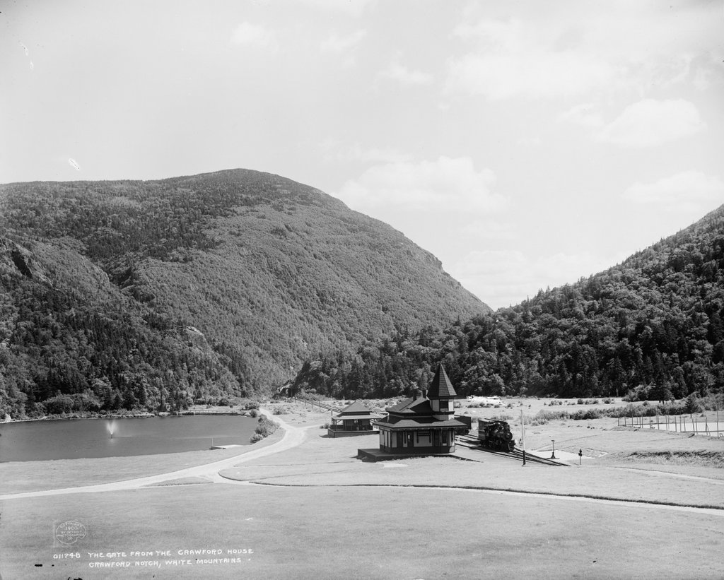
Crawford Notch, Carroll, New Hampshire

The view looking south toward Crawford Notch from the Crawford House in Carroll, New Hampshire, around 1900. Image courtesy of the Library of Congress, Detroit Publishing Company Collection.

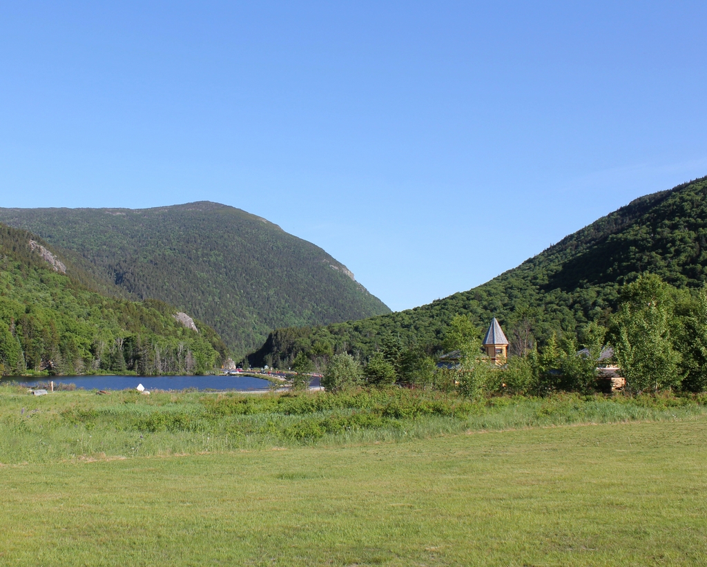
The scene in 2020:

As explained in an earlier post that shows the view from the opposite direction, Crawford Notch is an important mountain pass that, for many years, was the only east-west route through the White Mountains. The notch, which was originally barely 20 feet wide, was unknown to European colonists until 1771, when two settlers discovered it while hunting. It soon became a major transportation corridor, beginning with a rough road that was later upgraded for stagecoach travel. By the late 19th century, a railroad also ran through the notch, as shown by the tracks and station building in both photos.

Like most mountain passes, Crawford Notch forms the divide between two major rivers. In the foreground of this scene is Saco Lake, the headwaters of the Saco River. From here, the river runs through the gap in the mountains, which is known as the “gates” of Crawford Notch. The river then flows through a narrow, steep-sided gorge for several miles, and it ultimately flows through Maine and into the Atlantic Ocean a little south of Portland. On the other side of the divide is the Crawford Brook, which rises just behind where these photos were taken and flows into the Ammonoosuc River. The Ammonoosuc River then flows into the Connecticut River, which eventually reaches the ocean in Long Island Sound.

These two photos show perhaps the most dramatic view of Crawford Notch, looking south from right about the point where the two watersheds divide. From here, the relatively broad, flat valley on the north side of the notch narrows to a small opening that is flanked by steep cliffs on either side. Just to the left of the notch is a rock formation known as Elephant Head, and on the right is the eastern slope of Mount Willard. However, the most prominent landscape feature here is Mount Webster, which forms an impressive backdrop to the scene. At 3,911 feet in elevation, its summit rises two thousand feet above the floor of Crawford Notch, and it forms the southern end of the Presidential Range.

Given the amount of traffic that was funneled through Crawford Notch, the area was the site of several hotels and inns in the early 19th century. Perhaps the most famous of these was the Willey House, located about three miles south of here. In 1826, the occupants of the inn were killed in a landslide, after they fled the house in the middle of the night in an effort to escape the falling rocks and mud. Ironically, the building itself was unharmed by the landslide, and the tragic event was subsequently immortalized in paintings and literary works.

Many accounts of the tragedy made it a moral lesson about the untamed power of nature, yet it did little to dissuade visitors to Crawford Notch. If anything, it seemed to have the opposite effect, and by the mid-19th century the area was no longer simply a convenient transportation corridor; it had become a destination in its own right. Among those who benefitted from this was the Crawford family, for whom the notch is named. In 1828, just two years after the landslide, Ethan Allen Crawford built the Notch House here at the gates of Crawford Notch, and his brother Thomas subsequently ran it for many years. From here, the Crawfords offered guided tours to the summit of Mount Washington via the 8.5-mile Crawford Path, which Ethan Allen Crawford and his father Abel had cut in 1819.

The original Notch House was located in the distance of this scene, close to the actual notch. However, in the early 1850s Thomas Crawford began construction on a new hotel just to the north, located where these two photos were taken. He ran into financial difficulties and had to sell the half-finished hotel, but it was completed under new ownership. However, the building was destroyed by a fire in 1859, and was subsequently rebuilt and reopened later in the year. Known as the Crawford House, it became a popular tourist destination throughout much of the 19th and 20th centuries. It ultimately closed in 1975, and burned two years later.

When the Crawford House opened, there was no rail service through Crawford Notch. However, this changed in 1875, when the Portland & Ogdensburg Railroad opened here. This railroad was subsequently acquired by the Maine Central Railroad in 1888, and in 1891 the new owners built a Queen Anne-style station here at the Crawford House, which is visible in the foreground of both photos. The first photo shows a locomotive at the station, Maine Central No. 101, a 4-4-0 steam locomotive that was built in 1889 and scrapped in 1916.

Today, around 120 years after the first photo was taken, relatively little has changed in this scene. Right behind where the photos were taken, the Crawford House is long gone, and it is now the site of the Appalachian Mountain Club’s Highland Center. However, the view south toward the notch looks much the same as it did in 1900, including the historic railroad station, Saco Lake, and the surrounding landscape. Most of the land within Crawford Notch is now part of the Crawford Notch State Park, which was established in 1913, and the surrounding land on the mountains is part of the White Mountain National Forest, which was established in 1918.